

Located in the northeastern corner of the Malay Peninsula, Kelantan is said to translate as the Land of Lightning. An agrarian state with green paddy fields, rustic fishing villages and casuarina-lined beaches, Kelantan is home to some of the most ancient archaeological discoveries in Malaysia, including several prehistoric aboriginal settlements. The honorific name of the state is Darul Naim or the Blissful Abode. Kelantan is the only state outside of East Malaysia that does not use the term district in its second-level administrative division. Instead, the districts are named as colonies (Jajahan), or collectivities and one autonomous subdistrict. The capital, Kota Bharu, includes the royal seat of Kubang Kerian.
Kelantan is bordered by Narathiwat Province of Thailand to the north, Terengganu to the southeast, Perak to the west and Pahang to the south. To the north-east of Kelantan is the South China Sea. Due to Kelantan’s relative isolation and largely rural lifestyle, Kelantanese culture differs somewhat from Malay culture in the rest of the peninsula; this is reflected in the cuisine, arts and the unique Kelantanese Malay language, which is unintelligible even for some speakers of standard Malay.
Kelantan has diverse tropical rainforests and an equatorial climate. The state’s mountain ranges belong to the Titiwangsa Mountains, which are part of the Tenasserim Hills that span throughout southern Myanmar, southern Thailand and Peninsular Malaysia, with Mount Yong Belar being the state’s highest point.

There are several suggestions for the origin of the name Kelantan. One theory proposes that the word Kelantan comes from a modified version of the word gelam hutam, the Malay word for the cajuput, or swamp tea tree. Other theories claim that the name comes from the Malay word kilatan, which translates to shiny or glittery or kolam tanah, which means a clay pool. Kelantan was called Kalantan by the Siamese when it was under their influence.
Kelantan’s early history is not very clear, but archaeological evidence shows human settlement in prehistoric times. Early Kelantan had links to the Funan Kingdom, the Khmer Empire, Sri Vijaya, Majapahit and Siam. Around 1411, Raja Kumar, the ruler of Kelantan, became independent of Siam, and Kelantan became an important centre of trade by the end of the 15th century.
In 1499, Kelantan became a vassal state of the Malacca Sultanate. With the fall of Malacca in 1511, Kelantan was divided up and ruled by petty chieftains, paying tribute to Patani, then a powerful Malay kingdom of the eastern peninsula. By the early 17th century, most of these Kelantan chiefs had become subject to Patani. Kelantan made a political alliance with Patani during the reign of Raja Biru in 1619 for mutual trade and military interests. The Queen of Patani was deposed in 1651 by the Raja of Kelantan, starting a period of Kelantanese rule in Patani.

Around 1760, Long Yunus, an aristocratic warlord of Patani origin, succeeded in unifying the territory of present-day Kelantan and was enthroned by his father-in-law, Ku Tanang Wangsa, the Regent of Terengganu, as Yang di-Pertuan Muda or Deputy Ruler of Kelantan. Long Yunus was succeeded in 1795 by his son-in-law, Tengku Muhammad, by Sultan Mansur of Terengganu. The enthronement of Tengku Muhammad by Terengganu was opposed by Long Yunus’ sons, thus triggering a war against Terengganu by Long Muhammad, the eldest son of Long Yunus. The pro-Terengganu faction was defeated in 1800 and Long Muhammad ruled Kelantan with the new title of Sultan as Sultan Muhammad I. Later, when the new sultan died childless, it triggered another civil war among claimants to the throne. His nephew, Long Senik Mulut Merah, triumphed over his uncles and cousins and assumed the throne in 1835 as Sultan Muhammad II. Sultan Muhammad II leveraged his loose alliance with Siam to form the modern Kelantan state, centred in his new fort on the eastern bank of the Kelantan River, which became Kota Bharu in 1844.
Under the terms of the Anglo-Siamese Treaty of 1909, the Thais relinquished their claims over Kelantan, Terengganu, Kedah and Perlis to the British Empire, and Kelantan thus became one of the Unfederated Malay States with a British adviser. Kelantan was where the Japanese first landed during their invasion of Malaya, on December 8, 1941. In 1943, Kelantan was transferred by the Japanese to Thailand during World War II and became a province of Thailand. Kelantan reverted to Malaya upon the end of World War 2 in August 1945.
Kelantan became part of the Malayan Union in 1946 and then the Federation of Malaya on February 1, 1948, and together with other Malayan states, it attained independence on August 31, 1957. On September 16, 1963, Kelantan became one of the states of Malaysia.
From Kuala Krai, the conjoined streams become the Kelantan River, also known as Sungai Kelantan, a broad, mud-coloured stream that dominates the fertile coastal plains and defines the geography of the region. The Kelantan River valley is a fertile rice bowl, rich in hardwoods and rubber and lush with tropical fruits.
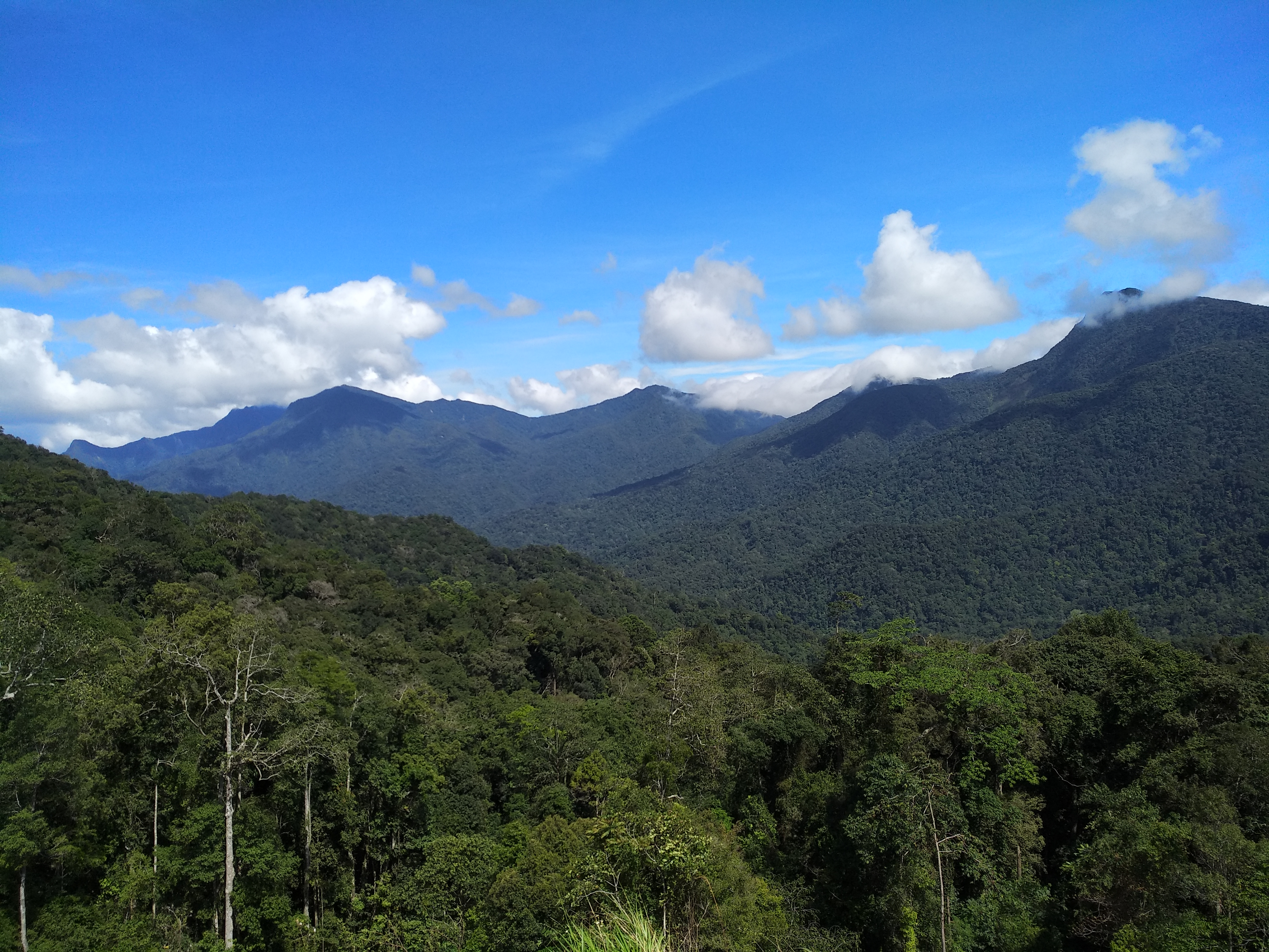
For centuries, Kelantan was all but separated from the rest of the country by the Titiwangsa Mountains, a mountain range running from north to south through the peninsula. Weeks of hard travel were required to reach Kelantan. The easy way to Kelantan was to sail around the peninsula, braving the sea and pirates. For this reason, Kelantan’s history often involves the sea and boats. Even today, many of its people are very much tied to the sea. A discussion with many coastal residents will confirm that their ancestors, as far back as they know, were of the sea.
During the 1920s, in the days of British colonial rule, a railway line was built, linking Tumpat on the state’s northern coast, through the jungles of upper Kelantan and Pahang and then on to other states. Also, between the 1920s and 1980s, trunk roads were built to link Kelantan with adjacent states.
Kelantan has a chiefly agrarian economy dominated by rice, rubber and tobacco. Fishing along its 96-kilometer coastline is also an important economic activity. Cottage industries that employ traditional skills in handicraft production, such as batik, woodcarving and songket weaving, are also evident. Logging activities are active, given the vast remaining area of forest. In recent years, tourism, especially to offshore islands, has increased in importance. Kelantan’s GDP is significantly lower than that of any other state in Malaysia.

Kota Bharu, the capital, is the major urban centre, and there are also plans to open up the southern portion of the state under an ambitious multimillion-dollar development project. The main market in the city centre is a top attraction.
Colloquially referred to as KB, Kota Bharu serves as the state capital and royal seat of Kelantan. It is situated in the northeastern part of Peninsular Malaysia and lies near the mouth of the Kelantan River. The town is home to many religious buildings and museums. The unique architecture of the old royal palaces is still occupied by the sultan and sultanah and is off-limits to visitors but viewable from the outside.
Kota Bharu means the new city or new castle or fort in Malay. Occasionally, the name of the city is written as Kota Baharu. Kota Bharu was founded during the late 19th century. Before its establishment, Kota Bharu was home to Kelantan’s Royal Palace, then established by Sultan Muhammad II of Kelantan in 1844 as Kelantan’s state capital who wanted the new state capital built in his honour. Before this, Kota Bharu was known as Kuala Kelantan. Before Kota Bharu assumed the role, the Kelantanese capital was divided into two which were Kota Kubang Labu and Kota Pengkalan Datu. During the 19th century, Kelantan was a prosperous and populous state with a population of around 30,000 to 50,000 people including a thousand Chinese. Production from within the state included gold, tin ore, black pepper, areca nut, rice, rattan, bamboo, agarwood and songket. Kota Bharu acts as an entrepot for goods due to its strategic location beside the Kelantan River.

During World War II, Pantai Sabak, about 10 km from Kota Bharu, was the initial landing point of the Japanese invasion forces on 8 December 1941, which began the Battle of Kota Bharu, the first battle of the Malayan campaign. Japanese forces captured the city and would go on to successfully engage the British in jungle warfare and ultimately capture Singapore.
The city was declared a Cultural City on 25 July 1991 by the late Sultan Ismail Petra based on two important aspects – the history of Kota Bharu and the uniqueness of its local arts and cultures. Kota Bharu was rebranded as the Islamic City, Bandar Raya Islam in Malay, by the Kelantan State Government on 1 October 2005 through its Developing With Islam or Membangun Bersama Islam policy.
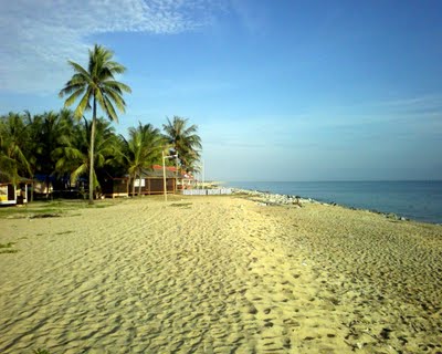
Diving in Kota Bharu is a relatively new activity. At present, only one dive shop operates in the area. Trips out to the wreck of the IJN Awazisan Maru, known locally as the Japanese Invasion Wreck are among the sites offered. This Japanese transport ship was the very first vessel to sink in the Pacific War. The wreck is a 30-minute boat journey from a jetty which is 10 minutes outside of Kota Bharu. Strong surf threatens all major beaches in the vicinity of Kota Bharu with substantial erosion. The community has been implementing wavebreakers by piling up massive amounts of boulders to protect the coastline. Regular beach activity has become impossible as visitors frequent beaches further south. In terms of tourism, the most famous beach in Kota Bharu is Pantai Cahaya Bulan. Once known as Pantai Cinta Berahi or the Beach of Passionate Love, today it is known as Pantai Cahaya Bulan or Moonlight Beach in keeping with Islamic sensibilities. Locally known as PCB, erosion events have seen the installation of a concrete breakwater, but PCB’s sandy sprawl is still worth considering for a seafood lunch. The road leading to PCB is quite pretty, especially by bicycle, and there are batik shops and workshops along the way. The Irama Bachok Beach is located within the Bachok District and is the main tourist spot for Bachok District residents and Kelantan residents in particular. The Pantai Bisikan Bayu or the Beach of Whispering Breeze is also known as Pantai Dalam Rhu. The gentle breeze at the beach produces a hushed sound that, locals say, sounds like a soothing whisper.
