
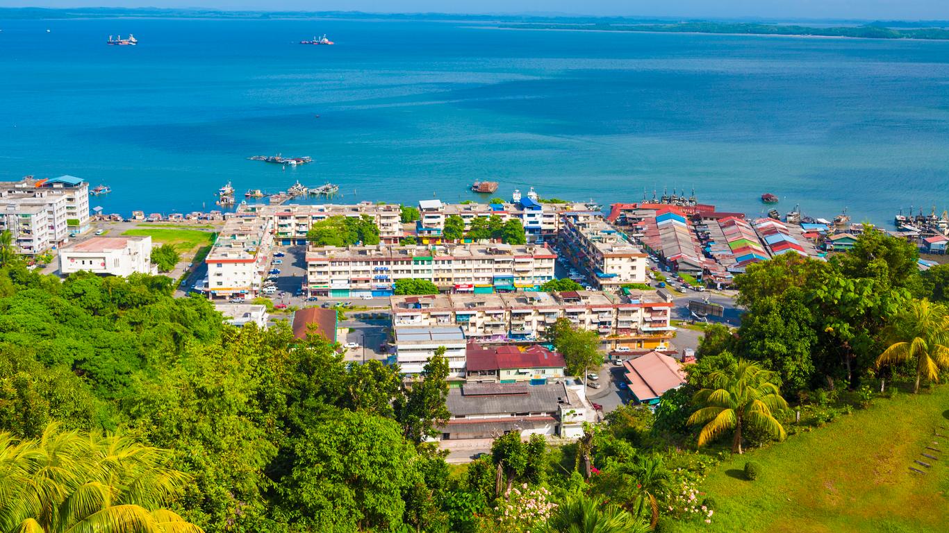
Sandakan
Formerly known at various times as Elopura, Sandakan is the second largest city in Sabah after Kota Kinabalu and is located on the Sandakan Peninsula on Sabah’s east coast.
Before the founding of Sandakan, the Sulu Archipelago was the source of dispute between Spain and the Sultanate of Sulu for economic dominance in the region. By 1864, Spain had blockaded the Sultanate’s possessions in the Sulu Archipelago. The Sultanate of Sulu awarded a German consular service ex-member a piece of land in the Sandakan Bay to seek protection from Germany. In 1878, the Sultanate sold north-eastern Borneo to an Austro-Hungarian consul who later left the territory to a British colonial merchant. The German presence in the area raised concern among the British. As a result, a protocol was signed between the British, German and Spanish to recognise Spanish sovereignty over the Sulu Archipelago, in return for the Spanish not intervening in British affairs in northern Borneo.
Sandakan began to prosper when the British North Borneo Company, BNBC started to build a new settlement in 1879, developing it into an active commercial and trading centre as well as making it the main administrative centre for North Borneo. The British also encouraged the migration of the Chinese from British Hong Kong to develop the economy of Sandakan. However, the prosperity halted when the Japanese occupied the area. As the war continued and Allied bombing started in 1944, the town was destroyed. Unable to fund the costs of the reconstruction, the administrative powers of North Borneo were handed over to the Crown Colony government. Subsequently, the administrative capital of North Borneo was moved to Jesselton.

The first European settlement was built by a Scottish arms smuggler from Glasgow named William Clark Cowie who named the settlement Sandakan, which in the Suluk language means the place that was pawned. It was soon renamed Kampong German, due to the presence of several German bases there. When another new settlement was built shortly after the previous Cowie settlement had been destroyed by a fire, it was called Elopura, meaning beautiful town by the British North Borneo Company but the locals persisted in using the old name and later it was changed back to Sandakan. Besides Elopura, it was also nicknamed Little Hong Kong due to the strong presence of ethnic Chinese migration from Hong Kong, mainly Cantonese and Hakka.
Sandakan is one of the six districts that is involved in the Eastern Sabah Security Command or ESSCOM, a dusk-to-dawn sea curfew which had been enforced since 19 July 2014 by the Malaysian government to repel attacks from militant groups in the Southern Philippines. Sandakan is located about 28 km from the international border with the Philippines.

The Kinabatangan River is one of the most prominent and accessible places in Asia to see a variety of flora and fauna. The river is home to more than 200 bird species and more than 50 mammals along with ten primate species. The significant animals are the proboscis monkey and the Bornean gibbon. The river is about 560 km long and is Malaysia’s second-longest river. The name Kinabatangan is a reference to the early Chinese trades who settled around the river mouth of the river. The word Kina is a direct reference to the Dunsun tribe of the Chinese settlers. Chinese traders had settled in the river mouth of Kinabatangan since the 7th century and used trading as a means to live their livelihood. Visitors can opt for a boat ride from Sandakan Yacht Club to the Sukau Rainforest at 1 pm. The boat ride to the lodge takes less than 3 hours and visitors can also get a glimpse into Borneo’s wildlife and natural beauty.
The Kinabatangan River basin has five different habitats: waterlogged forests, saline swamps, dry forests, freshwater swamps, and limestone forests. The distinct habitats allow wildlife to thrive and are home to several hundred species. The Kinabatangan Wildlife Sanctuary was founded in 2006 and safeguards 27,800 hectares of the area.
The river cruise is the top thing to do at Kinabatangan River. Several tour packages have different cruises at different price ranges. It’s a magical experience and visitors will be left in awe when they see the sunrise in the river. There are 3 river cruises every day and visitors can choose their ride timing according to their convenience. Timings for the River Cruises are 6 am, 4 pm and between 7 and 9 pm. The morning hours are great for visitors who want to gaze at birds while evening time is great for visitors who want to watch monkeys and crocodiles. The nighttime River Cruise ride is great for visitors who want to experience the river at night while observing the nocturnal animals.

The jungle Trek is an activity for adventure seekers only. Oxbow Lake is the prominent trekking site in this area and visitors are recommended to do planning before they begin the trek. Gomantong Cave is a bat haven and home to many swiftlets. The cave is an impressive wonder and is also a hotspot for several other animals, particularly orangutans. However, the cave is also full of cockroaches and faeces which can be disgusting for visitors. The river is one of the best spots to watch animals and birds thrive in their natural surroundings. The most prominent bird in this part is the Hornbill, which can be spotted easily. The Orangutans and wild monkeys are the more common animals found in this area.
The best time to visit Kinabatangan River would be March to September as this period foresees the least rain which can allow visitors to enjoy their trip more. This is also the best time to spot Orangutans and other forms of wildlife. The dry climate of these months allows visitors to spot more wildlife and travel more comfortably.

The Sandakan Heritage Museum is located on the 1st floor of the Wisma Warisan building, next to the Sandakan Municipal Council and is part of the Sandakan Heritage Trail. The museum showcases the pre-war and post-war history of the town—various artefacts including barter trade items, authentic office equipment in the 1920s and traditional agricultural equipment. Portraits of local leaders and early scenes of the town are prominently displayed with the most eye-catching being the large mural of Sandakan in 1935 in the museum’s hallway. The Martin and Osa Johnson Safari Museum in Chanute, Kansas, United States has relations with the museum with the digital copies of the Johnson photographs related to North Borneo are returned to the museum and the authority of Sabah Museum.
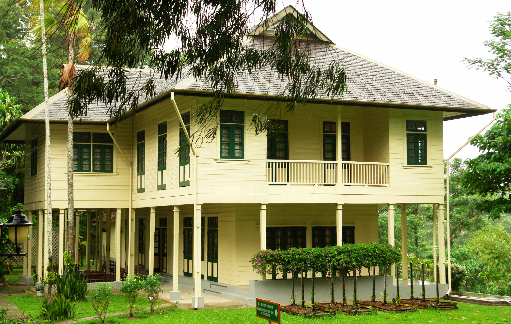
The Agnes Keith House, formerly known as the Newlands is a historic house museum named after Agnes Newton Keith, an American author known for her three autobiographical accounts of life in British North Borneo. The house was already constructed on a hill in the current site as a British colonial government quarters. In 1934, Agnes married Harry Keith, a British official forest conservation officer in Sandakan. After being destroyed in World War II, a new house was rebuilt between 1946 and 1947 on the hill of a destroyed house and became the first government permanent timber dwelling. The newly rebuilt house was renamed Newlands. Agnes lived in the house for several years before the house was owned by others. After being left unoccupied, the Sabah Museum Department together with the Federal Department of Museum and Antiquities began to collaborate in 2001 to restore the house and on 26 April 2004, it was finally opened to the public as a museum.
Agnes wrote about mysterious incidents throughout her stay where she saw a tall unrecognisable female figure apparition. The next occupant also experienced similar incidents. The house has been restored and turned into a heritage house since the restoration works in 2004. The house provides insights into life during the administration of British North Borneo and is furnished with a reproduction of colonial furniture and antiques. A gallery on the first floor tells the story of Agnes, her books and her family.
The Chartered Company Monument is a monument dedicated to the British servicemen or employees who were killed at the end of the 19th century. The monument was built by the British North Borneo Company and is part of the Sandakan Heritage Trails, a trail which connects the historic sights of Sandakan.
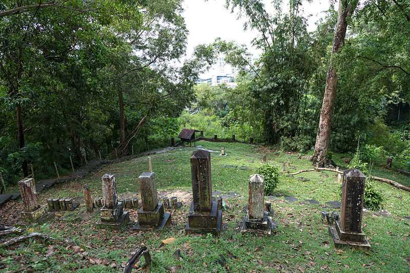
The Chinese Cemetery in Sandakan sprawls across a huge area and is regarded as one of the most fascinating burial grounds in Asia. One part of the cemetery is dedicated to the Chinese. Here, the graves follow the old feng shui principles. There is also an ancient charnel house which houses the remains of extended Chinese families. These houses depict Taoist guardian deities which protect the departed spirits from negativity. Another section of the Chinese Cemetery houses the remains of the Japanese community.

The Sandakan Japanese Cemetery is an old graveyard located on a hill about 2 km from the town’s central business district. It is a cemetery where many Japanese female prostitutes, known as Karayuki-san who came from poverty-stricken agricultural prefectures in Japan are buried. These young women were sold into slavery at a very young age years before World War II which also included recent comfort women during the war. It is part of the Sandakan Heritage Trail.

The Sandakan Massacre Memorial consists of three monuments which commemorate 30 Chinese victims, most of whom were the local elite of an underground movement executed on 27 May 1945 along with several other victims during the Japanese occupation of North Borneo. The memorial was built on the spot where the massacre took place and where the victims were buried. It is located near a Chinese cemetery on a hill above the old town centre of Sandakan. The memorial is located near the entrance to the Sandakan Chinese Cemetery. Right next to the gate, it is surrounded by a tiled square of six metres long. Link chains connected by stone pillars limit the memorial, which consists of approximately three metres high stele and two flanking memorial stones.

The Sandakan Memorial Park is a memorial site built on the former grounds of the former Sandakan camp. The site is dedicated to the prisoners in the camp who died during the Sandakan Death Marches, and to those who died during a march to Ranau. It also recognises the suffering and sacrifice of the native population. This park hosts the Sandakan Memorial Day service on August 15.
The memorial park is located about 1.5 km southwest of present-day Sandakan Airport, which occupies part of the former camp of the Australian B Force. The memorial is divided into six stations that are connected by a circular route. The excavator was used for the construction of an airport for the Japanese. During repairs, it was sabotaged by Australian prisoners of war rendering it inoperable and so it never worked again. The steam generator and other generators became the main power source for the camp. The wood-fired steam engine-powered generator was used for the lighting of the camp and its enclosure. The Great Tree is a huge specimen of a Mengarisbaumes that originally stood where the memorial obelisk is placed today. It was the dominant structure of the POW camp by its size. Shortly after the war, the tree was destroyed by a fire. A new Mengarisbaum was planted near the entrance on 25 April 2008 for the park. The Japanese also operated a food depot and kitchen with a water tank preserved in concrete. The main entrance was on the east side of the memorial park before the storage area. The road leading to the airport and to the left and right was the Mile 8 Road street from Sandakan to Ranau. It was from here, that all three marches began to Ranau. The Sandakan Commemorative Pavilion was opened on 18 March 1999 and contains a permanent exhibition about the POW camp and the death marches in both English and Malay languages.

The Sandakan War Monument is a monument established by the British to commemorate citizens who died during the Second World War. The monument is part of the Sandakan Heritage Trails, a Heritage Trail which connects all of Sandakan’s historic sights.

The William Pryer Monument is a monument in memory of the founder, William Burgess Pryer. It is part of the Sandakan Heritage Trails, a trail which connects all the historic sights in Sandakan. The monument site changed frequently. In the 1950s, the monument stood on a square that today is known as the site of the Sandakan Municipal Council. In the early 1960s, the monument was located near a field and later relocated again when Sandakan North Road was converted into a four-lane road. Its current location is on MPS Square, fronting the Municipal Council building along with other monuments such as the Chartered Company Memorial after the transformation of the site, which was a former hockey field.

St. Mary’s Cathedral or Sandakan Cathedral, is the cathedral and mother church of the Roman Catholic Diocese of Sandakan. Founded in 1883, it is the oldest church in Sandakan. During the 19th century, it was erected as a prefecture based in Labuan. In the period established in the territory of the various mission stations, including the mission of Santa Maria of Sandakan, a small town on the coast of the island of Borneo.

The Sam Sing Kung Temple, also known as the Three Saints Temple is the third oldest temple in Sandakan after the Goddess of Mercy and Tam Kung Temples. Built in 1887, the temple is part of the Sandakan Heritage Trail. The temple has undergone several recent renovations. The temple was originally established as a religious centre for Chinese migrants who had arrived from Guangdong, and the Qing Dynasty. The temple is also called the Three Saints Temple with the three saints referring to Kwan Woon Cheung, the saint of righteousness, the Goddess of Tin Hou who is worshipped by fishermen and seamen for protection, and the Min Cheong Emperor who is worshipped by hopeful students who seek success in examinations. The temple has a collection of 100 pre-printed Taoist Divination Poems. Its bronze bell was donated by the first Kapitan Cina of Sandakan, known as Fung Ming Shan who was appointed by the British rulers in 1887 to manage and oversee the Chinese community in the town.

Nestled on the Tanah Merah hill, the Puu Jih Syh Temple is the largest Chinese temple in Sandakan. The highlight is the panoramic view of the Sandakan city and the Sulu Sea from this Buddhist-Chinese temple. Kuan Yin, the Goddess of Mercy and Passion is the principal deity. The temple is adorned with shades of red and golden, while its roofs are adorned with paintings of Chinese dragons. Traditional Chinese architecture, gleaming lanterns, a huge variety of flowers, statues and Buddhist intricate works further accentuate its beauty.

The Sandakan Jamek Mosque, also known as Masjid Jamek Sheik Hasabollah At-Tohiri and was opened in 1890. It is the oldest mosque in Sandakan and part of the Sandakan Heritage Trail. The mosque was opened in 1890 by Damsah, a Muslim cloth merchant from the British Raj in present-day India. During World War II, the mosque was a hidehole for the town’s Muslim population from the Japanese. The Japanese military believed the mosque was also the hiding place for British soldiers leading them to shoot the mosque several times during the war.
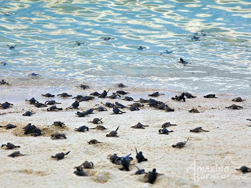
Turtle Islands Park is located within the Turtle Islands, which lie in the Sulu Sea some 3 km north of Sandakan. It consists of 3 islands – Selingaan, Little Bakkungan and Gulisaan, including the surrounding coral reefs and ocean. The Park is noted for its green turtles and hawksbill turtles which lay their eggs on the beaches of the islands. The Park covers an area of 17.4 sq km. The name Turtle Islands, however, refers to 10 islands, 3 of which are part of Turtle Islands Park of Malaysia, and 7 which belong to the Turtle Islands Wildlife Sanctuary of Tawi-Tawi province, Philippines.
Only on Selingan are there chalets for overnight visitors, and those who wish to see the turtles laying eggs must stay overnight. A curious fact of the three islands is that turtles come ashore nightly, not only during certain seasons and thus one is virtually guaranteed to see them. During the peak season in October, up to 50 turtles come ashore to lay eggs. Park rules are strictly enforced and visitors are not allowed on the beach from sunset to sunrise so as not to disturb the turtles. The eggs are collected and the visitors vacate the beach immediately so as not to scare away other turtles, which are very sensitive to movement on the beach. After the laying and collection of eggs and eventual tagging of the turtle, if it is a first-time visitor, tourists are allowed into the hatchery to observe the further work of the rangers: the transplantation of the freshly laid eggs into a man-made incubation chamber. The chamber is no different from that of the turtle: between 60 and 75 cm deep, in the sand, but within a protected hatchery to make it impossible for natural predators to dig the nests open. Since temperature determines the sex of the turtles, part of the hatchery is shaded, while the rest remains under the open sun. After the transplantation of the eggs, visitors will get turtle hatchlings—baby turtles—to release into the sea, which is also done by night to further increase their chances of survival.

Not all nests are emptied by the park rangers, but some remain undisturbed and develop naturally. By conserving the turtles, the park does not want to endanger other wildlife on the island: many animals that are natural predators of the turtles, such as monitor lizards, a crab specialising in turtle hatchlings, eagles and other birds, and marine animals such as sharks. They need the turtles for their survival. The turtle conservation programme in Sabah is the oldest in the world and has the most detailed statistics and research. Marine turtles have been around for at least 230 million years, but because of human activities, they have been brought, over the past hundred years, to the brink of extinction.
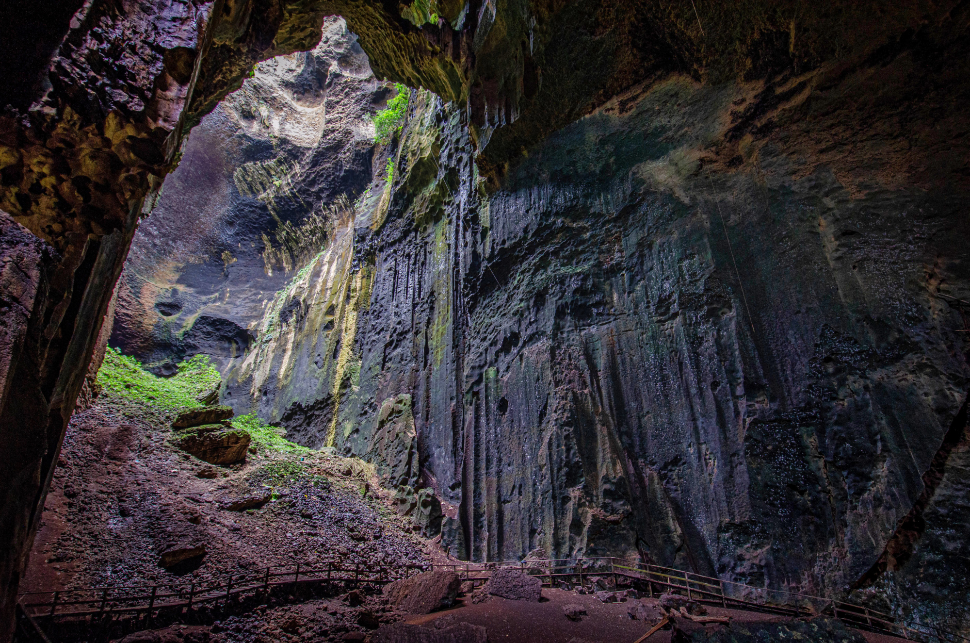
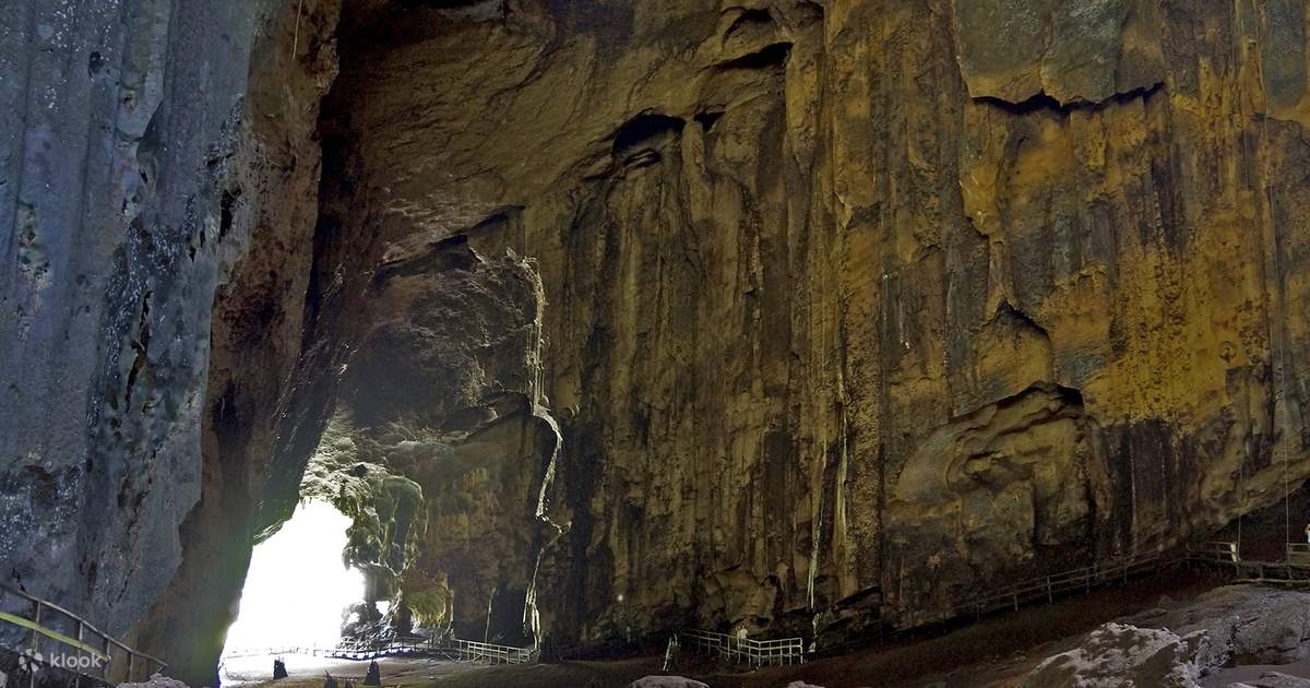
The Gomantong Caves are an intricate cave system inside Gomantong Hill and the hill is the largest limestone outcrop in the Lower Kinabatangan area. Situated in the Gomantong Forest Reserve, the caves and the surrounding area are a protected area for wildlife, especially orangutans. The limestone hill is also the only known site for the endangered land snail Plectostoma mirabile. Investigation of the guano deposits was first made in 1889 by J.H. Allard of the China Borneo Company, and the caves were first mapped by P. Orolfo in 1930. Detailed re-mapping and laser scanning of the caves was conducted in 2012 and July 2014.
The bat population is dominated by a colony of the wrinkle-lipped free-tailed bat, whose nightly exodus is a popular tourist attraction. There are also bat hawks that linger not far from the scene and prey specifically on the bats as they leave their roost.
For centuries, the caves have been renowned for their valuable edible swiftlet nests, which are harvested for bird’s nest soup. The most valuable of the nests, the white ones, can sell for very high prices. The birds’ nest collection is an ancient tradition, and the trading of these nests has been done since at least 500 AD. Twice a year, from February to April and July to September, locals with licenses climb to the roof of the caves, using only rattan ladders, ropes, and bamboo poles, and collect the nests. The first collection takes place early in the breeding season before the swiftlets lay their eggs. The birds then make another nest in which they finally lay their eggs. After the young have left the nest, the second collection is made. Care must be taken to ensure that the nests are collected only after the young swiftlets have abandoned these nests. Edible birds’ nests are protected under the Wildlife Conservation Enactment of 1997. Heavy fines and penalties are imposed on unlicensed collectors.
The main cave system is divided into two parts: the more accessible Simud Hitam or Black Cave, and the larger Simud Putih or White Cave which lies above. The names refer to the main type of nests produced by swiftlets in each cave. The cave system is home to many other animals, including massive populations of cockroaches, centipedes and bats. Outside one can see many raptors including crested serpent eagles, kingfishers, and Asian fairy-bluebirds. Access is in the form of a wooden walkway circuiting the interior.

Simud Hitam or Black Cave the more accessible of the two caves is only a few minutes walk from the entrance building and is open to the general public. It is the source of the less-valuable black saliva nests. These contain both feathers and saliva and require cleaning afterwards. Simud Putih or the White Cave is the larger of the two caves, and also the more technical; it is not open to the general public, and access requires appropriate caving equipment and experience. It is where the more valuable white saliva nests of the swiftlets are found and is reached by a steep, 30-minute climb further up the mountains. The main entrance is located above and adjacent to the main lighthole at the back of Simud Hitam.
