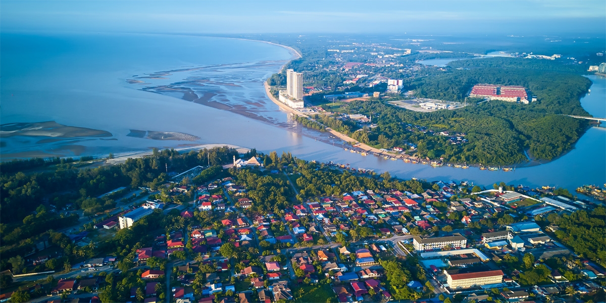
Travel Bucket List: Malaysia Part 13 – Pahang Part 3

Cherating
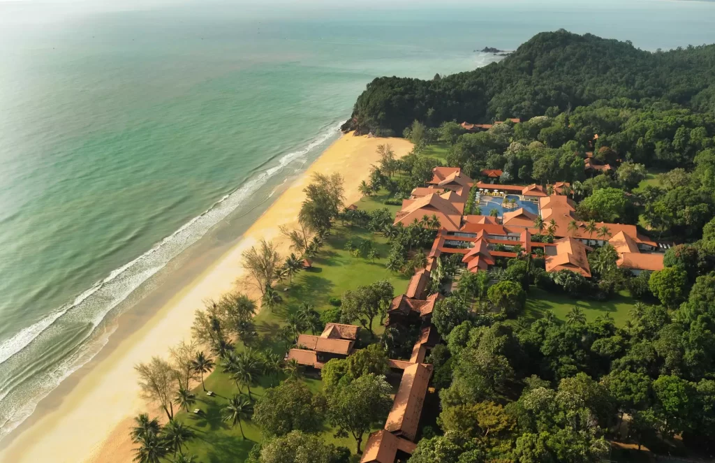
A coastal town, which is one of the wettest places in Malaysia, Cherating is famous for its beach resorts. Cherating also has the distinction of being the location of Asia’s first Club Med. This town is a Malaysian seasonal destination famous for white-sand beaches, surfing and windsurfing. Cherating’s Bay is an ideal spot for swimming most of the year, while surfing is popular during the monsoon months. Outside of the surf season, Cherating is quite empty which only adds to the appeal. The best time to visit Cherating would be the dry season, between April to October as there are heavy monsoons here that might end up disrupting the trip.

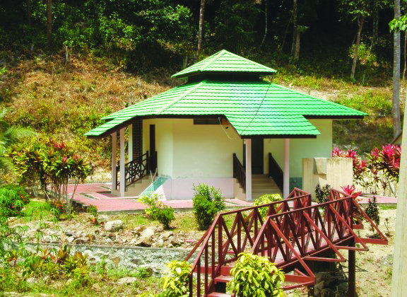
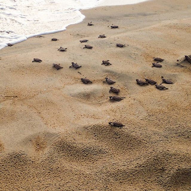
The major attraction of Cherating is the giant leatherback turtles which migrate yearly to reside on the beaches here. The showstoppers, however, are the mystical fireflies which reside on the trees along the banks of the rivers. Cherating has a cultural village which sells traditional textiles and handicrafts. There is a turtle sanctuary located on Cherating’s beaches. The turtles lay their eggs in July and August.

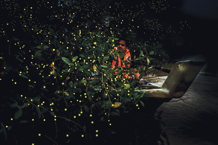
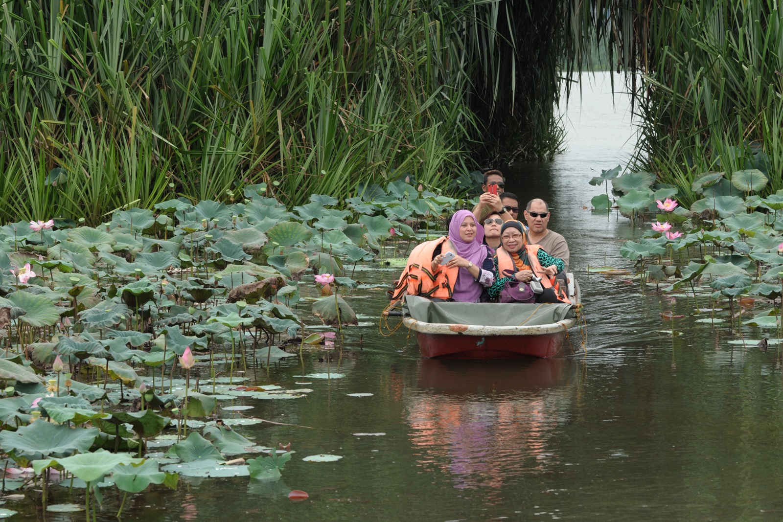
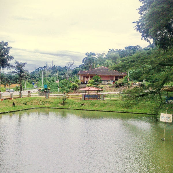
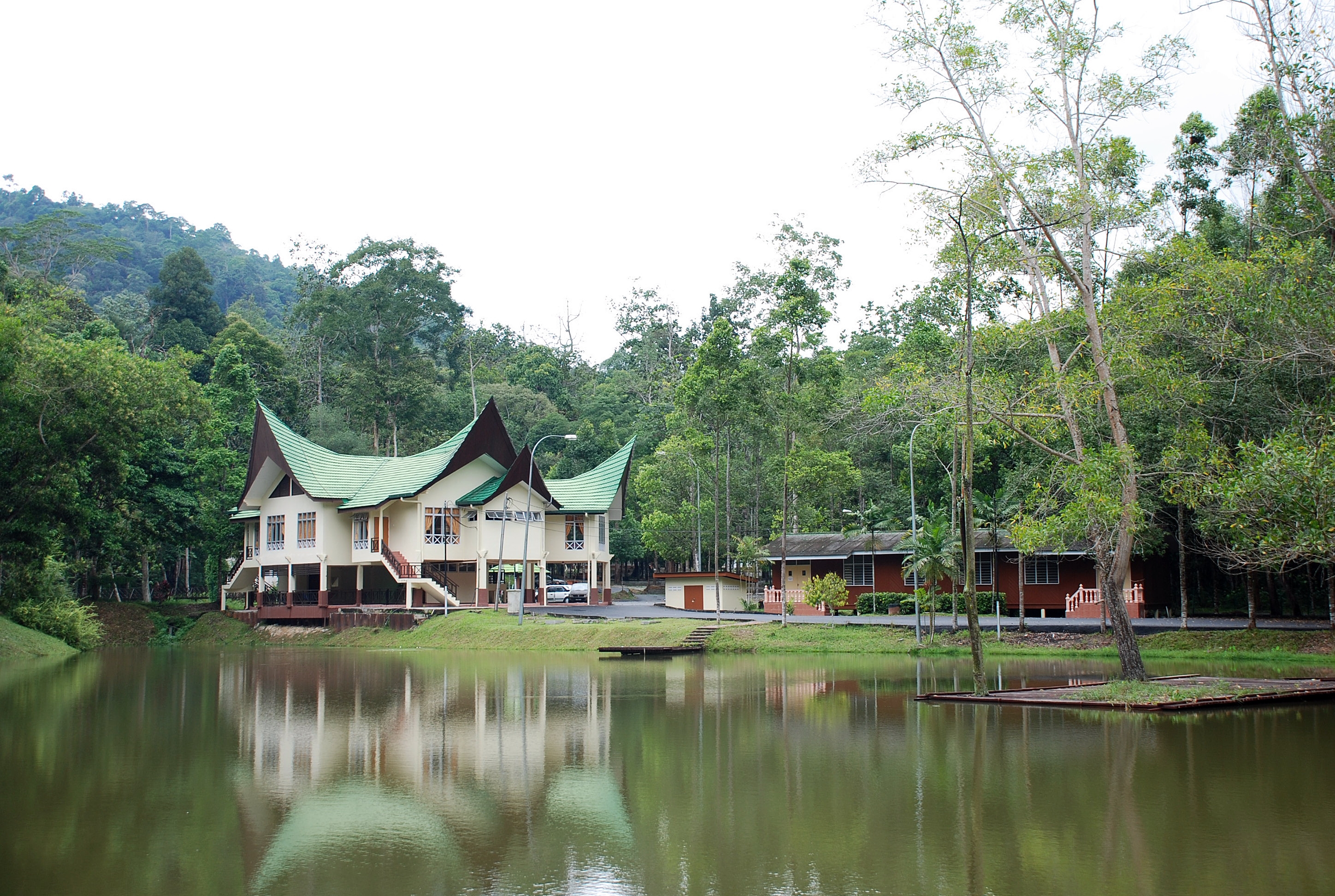
The Fireflies Tour is an hour-and-a-half-long boat tour which takes one through the waters of Cherating and explores the beauty of this popular beach town. The river cruise begins at 8 pm and has a fee of RM 35 per adult and RM 25 per child. The Malaysian Peninsula has only two natural lakes, both of which flow through Pahang and Lake Chini is one of them. It is Malaysia’s second-largest lake and is made up of a series of 12 smaller lakes. A tour of the lake takes one on a calm, serene ride through the lake with the tour guide reminiscing about the stories of the mythical dragon who lives in the lake and is the guardian of the lost city of gold which was once located underwater. The tour takes around 6.5 hours starting from any time between 8 am and 9:30 pm. The tour fee is 270 RM to 355 RM per child; and RM 520 to RM 757 per adult. An ATV ride lets one jump into one of the all-terrain vehicles and breeze through the beautiful sand beaches of Cherating. The ride fee is about RM 90 per person. At Cherating, one must not miss the opportunity to surf on the beautifully crested waves. There are many beachside surf clubs open for all which rent out surfing boards and surfing safety minikits.

At the Cherating Turtle Sanctuary, one is allowed to watch the nesting turtles and also witness the return of the ones who migrate to the east-coast every year, but only under the expert supervision of the turtle rangers of the Cherating Turtle Sanctuary. There are special areas on the shore where these giant turtles come to lay their eggs and then head back towards the sea. This process can be observed more frequently during the months from May through September ideally when the tide is hidden. Visitors can take a tour which takes between 3.5 and 4 hours to complete and is free, but if one wants to set up a tent to observe their daily behaviour, the fee is RM 30 per person. The Mangrove Cruise on the Cherating River is an hour-and-a-half-long cruise that gives one the chance to learn about the importance of mangroves in the ecosystem and the ways to protect them. Taking 90 minutes to complete, it costs RM 35 per adult and RM 25 per child.

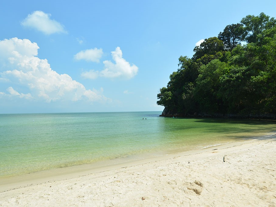
Chendor Beach is a white sand beach with shallow and clear waters that provide a beautiful picturesque destination. The well-maintained beach is just the perfect place to unwind leisurely and hang out with your friends and family, especially during the mesmerizing sunrise and sundown. The beach is well known for surfing.

Tioman Island
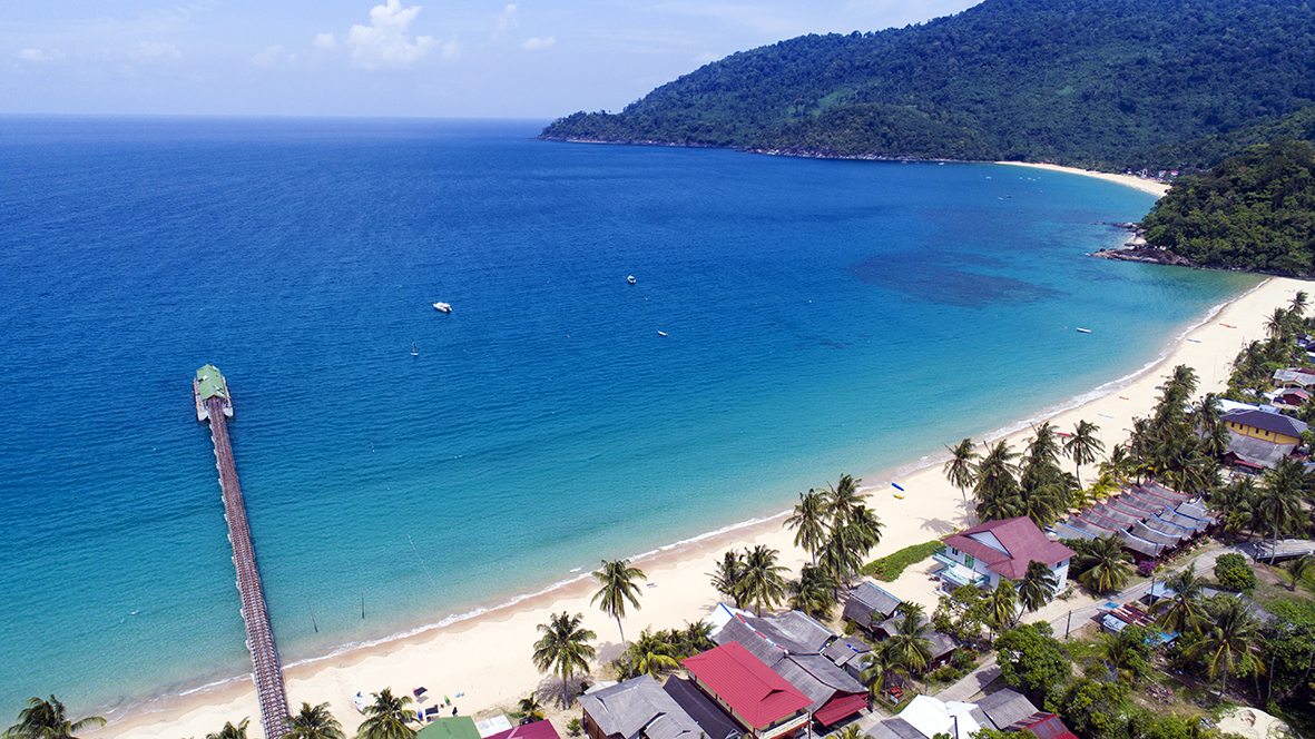
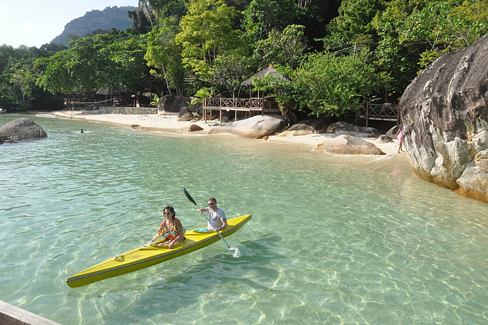
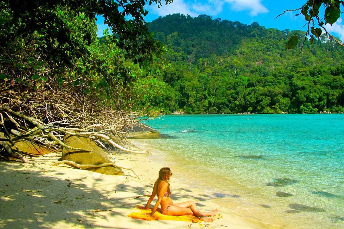
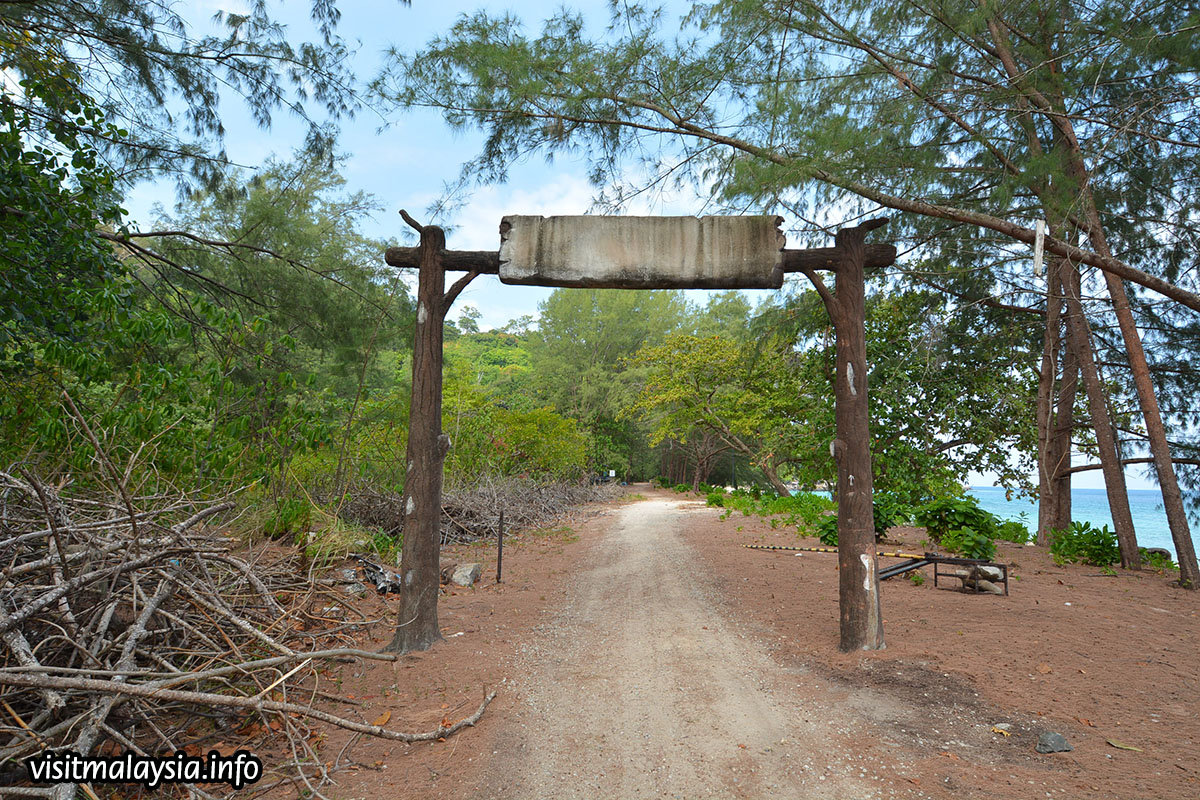
Lying about 32 km off the east coast of Malaysia, Tioman Island is 39 km long and 12 km wide and has seven villages, the largest and most populous being Kampung Tekek on the central western coast. The densely forested island is sparsely inhabited and is surrounded by numerous coral reefs, making it a popular scuba diving, snorkelling, and surfing spot. There are many resorts and chalets for tourists around the island, which has duty-free status. The island is accessed via ferry service from the coastal town of Mersing.

Tioman has been used for thousands of years by Austronesian fishermen as an essential navigation point and a source of fresh water and wood. During the past thousand years, it has played host to Chinese, Arab, and European trading ships, and often Chinese porcelain shards can be found on beaches around the island. In more recent history, Tioman played host to both the British and the Japanese navies during the Second World War. As a result, the waters around the island are littered with war remains, including HMS Repulse and HMS Prince of Wales. The island does not allow buildings to have more than three stories.

The marine area around Tioman Island and eight other nearby islands have been declared as marine parks and marine reserves. Apart from its diverse marine life, the inland rainforest area was protected in 1972 as the Pulau Tioman Wildlife Reserve. However, a large part of the original reserve was sacrificed for agricultural and touristic development in 1984; the remaining area is approximately 8,296 hectares. There are several protected species of mammals on the island, including the binturong, long-tailed macaque, slow loris, black giant squirrel, red giant flying squirrel, mouse deer, brush-tailed porcupine, and common palm civet, from a total of 45 species of mammals and 138 species of birds, including the majestic frigatebird. Tioman also has species that are endemic to its shores. The Tioman walking catfish Clarias batu can be seen on rainforest walks. The Kajang slender litter frog is only known to be found in Mount Kajang.

Tioman’s corals have been affected by a mass bleaching event in 2010 whereby the island lost a significant portion of its live coral cover. That resulted in many corals turning a dull white colour and some even fragmenting into pieces of dead coral skeleton. The 2016 bleaching event only touched on Tioman’s coral reefs, and as such, the coral has remained in good and healthy condition.

According to legend, Tioman Island is the resting place of a beautiful dragon princess. Whilst flying to visit her prince in Singapore, this beautiful maiden stopped to seek solace in the crystal-clear waters of the South China Sea. Enraptured by the charms of the place, she decided to discontinue her journey. By taking the form of an island, she pledged to offer shelter and comfort to passing travellers. Local mythology claims that the island is the embodiment of the mighty dragon Sri Gumom. The dragon was on his way to visit his sister Gunung Linga or Lingin Peak. Still, the great Sri Rama forbade the meeting, and Sri Gumom was turned into a stone and fell into the deep sea where he now remains, frozen in eternity as this beautiful island with its distinctive topography.

Like mainland Malaysia, Tioman Island has a hot and humid climate, with sunny afternoons and warm evenings but cool nights. Temperatures are usually consistent and the calm weather peppered with occasional showers and storms. The tourist season peaks between May and August, when the weather generally displays the least rainfall. The monsoon winds begin to blow in October, bringing heavy rain and strong waves till January which is the start of the surfing season. During this time, ferries run once a day, while only a few hotels will open at discounted rates. Still sparsely populated, most villages are connected by sea taxi or speedboat or jungle trail, which means visitors usually stay at their first ferry stop for the entire trip.

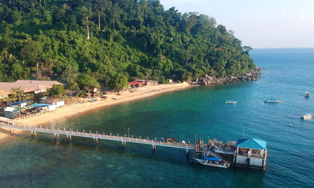
Among the seven villages, Air Batang Village, more commonly referred to as ABC Village, Juara and Kampung Tekek are the prime destinations. Kampung Telek is the administrative centre and the largest village of Tioman Island. It is the major spot connecting the island to Mersing and Tanjung Gemok through ferries. Tioman Airport is also located in Kampung Tekek. Sunbathing at Paya beach, rustic relaxation at Genting Village, surfing at Juara Beach, hiking to Asah Waterfall, snorkelling at Salang and a visit to a Marine Park Information Center is a must.

Overseas visitors to Tioman Island, are required to pay the Marine Park Fee which is RM 30. The most common way of getting to Tioman Island is by ferry from Mersing. Note that an entry fee of RM 10 known as Tioaman Toll has to be paid here. Ferries from Tanjung Gemok to Tioman Island need not pay a toll.

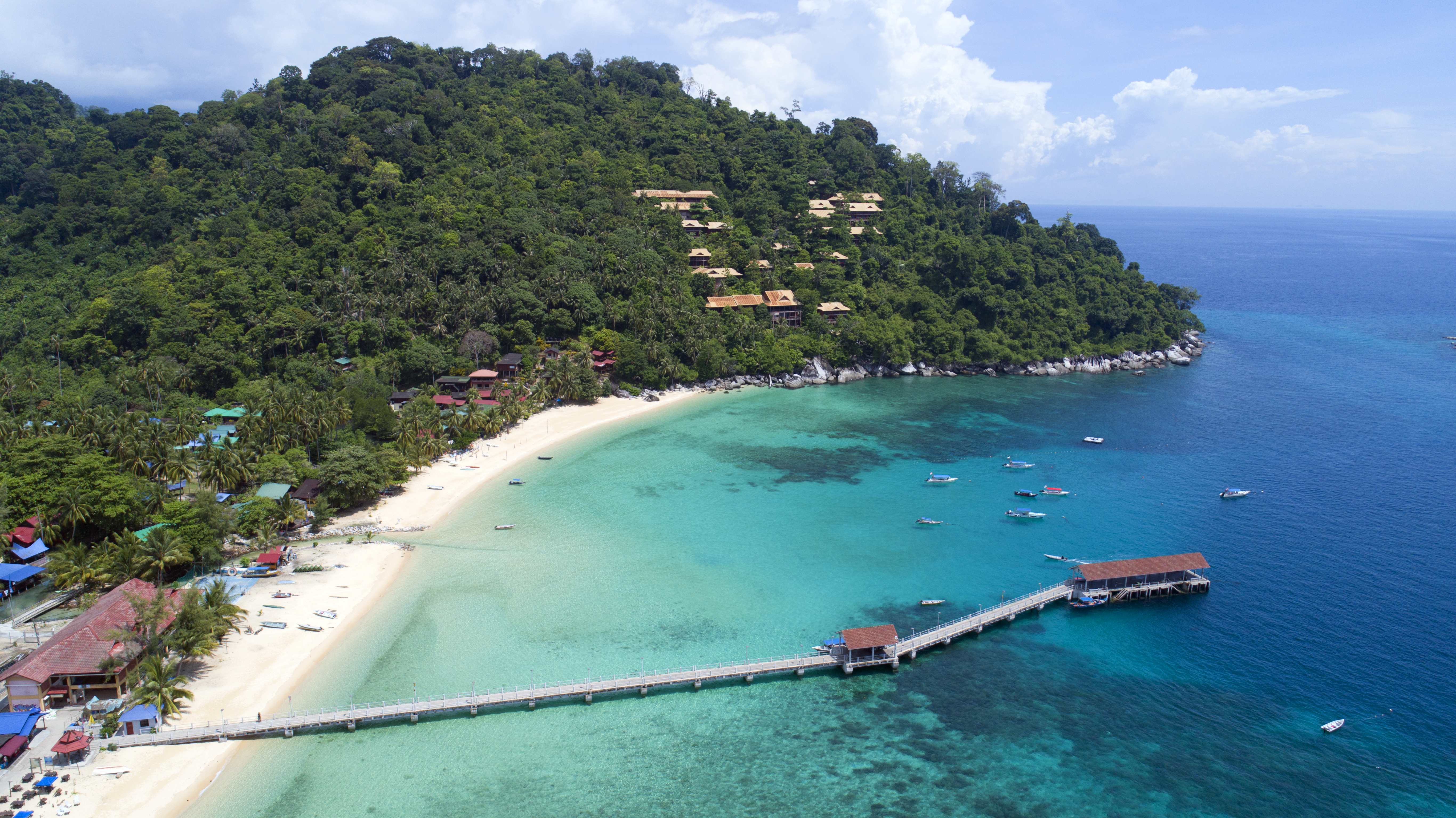
Paya is a small village with a beach on Tioman’s west coast. It’s a popular tourist spot, especially for Singaporean visitors and families, with two major resorts and a small-budget hotel providing chalet accommodation. The beach area stretches slightly more than half a km and is a beautiful expanse of fine white sand fringed by gentle seas. The deeper waters off the jetty and neighbouring Tomok Island are where living coral reefs reside for snorkelling activities, while cooling mountain streams, spectacular boulder formations and lush rainforest views occupy Paya’s hilly backyard, with a dramatic view of Gunung Kajang. The village is named after its abundance of mangrove swamps or paya in the local language. Behind the tatty wooden huts and homes along the beach, a shallow river feeds through a rich mangrove landscape, with boats parked at deeper sections under the shade of a thick forest canopy. Nature lovers will appreciate the rich rainforest scenery, with a jungle trail from Tioman Paya Resort that leads to Rock Falls, a rocky stream with small pools for swimming. At the northern end of the village, visitors can follow another trail across a moderate slope that ends at a beach, Teluk Sri Intan and then continue their journey on a gravel road to the TAT Turtle Sanctuary, before exiting out to Tekek town through Berjaya Tioman Resort. Finally, at the southern end of Paya, a partly paved jungle trail leads to Genting Village.

Genting is a large village along the west coast of Pulau Tioman, located between Paya and Nipah Village. It occupies a 1.5 km stretch of beach with a hilly backyard of lush rainforest. A favourite spot for mainland locals and Singaporean tourists, Genting has a sizeable collection of budget hotels and local restaurants clumped tightly along the beachfront. Weekends usually bustling with activity, people and karaoke music throughout the night. The sea here is moderately rocky, but the waters are clear while the large boulders give the landscape some aesthetic character. Most of the resorts offer chalet-based accommodations that spill along hill slopes from the beach.

Tekek is the largest village of Pulau Tioman, located along a 3 km coastal stretch at the island’s central west between Paya and Ayer Batang. Essentially its capital and progressively being developed into a proper town, Tekek has basic modern infrastructure. It is also the gateway to Juara by overland transfer and a hub for duty-free shopping. Tekek also has the largest concentration of dive centres, with most offering full board accommodation. Tourist attractions in the area include the Marine Park while restaurants and hawker stalls are widely available.

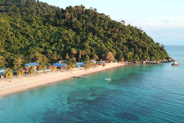
Salang is a popular beach destination north of Pulau Tioman, located along the west coast in a secluded bay. It attracts large crowds of global backpackers and is a great place for meeting people across the world over beer or two, with a good range of budget hotels along the beach and countryside. Salang is also a diver’s den, being the closest village to many reef sites and wrecks around Tioman, including Coral Island, Chebeh, Batu Malang and Fan Canyon. The last stop on the Mersing ferry route, Salang offers a good range of tourist facilities, activities and conveniences, backed by lush rainforest surroundings. The sea waters within this peaceful bay have great visibility, with warm stretches of sand along the shore and vibrant coral reefs under the ocean.

Air Batang, or ABC Village as it’s popularly known, is a rural village along the west coast of Pulau Tioman, immediately north of Tekek. Located south of Panuba Bay and 3 km before Salang via the jungle trail, the village is a traditional backpacker hideout, with a high concentration of budget hotels offering basic accommodation, though quite a few resorts have upgraded their chalets in recent years. The beach is a linear 1.5 km stretch of sand, with emerald clear waters and lush landscapes. At low tide, the seabed reveals a pretty carpet of boulders, pebbles and rocks of various sizes. A few dive centres operate within the vicinity while local and western food is easy to be found. A quick boardwalk connects the west end of Air Batang to the Marine Park directly.

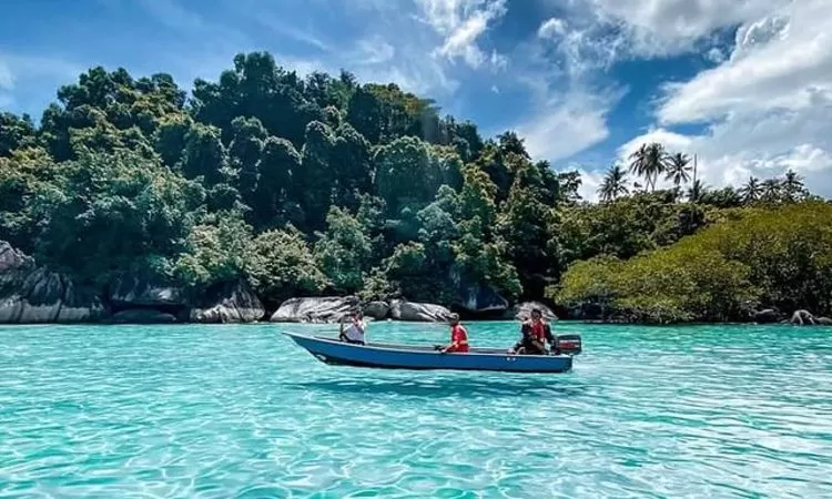
Pulau Tulai is a small island off the coast of Tioman, more popularly known as Coral Island. Located about eight nautical miles north of Tioman’s west coast, the island can be seen clearly from the beachfront of Salang Village, the closest access point by speedboat. It is almost always included in any round-island snorkelling trip offered by tour operators and hotels. A favourite snorkelling spot, the sea waters around the island are rich with coral reefs and marine life while some famous dive sites can be found within its vicinity, such as Chebeh. Tour boats will land first at Pasir Panjang, the longest beach stretch on the island with relatively shallow waters. A second or third snorkelling session later will lead to Genting Bay and Batu Malang Rocks for deep water coral viewing.

Pulau Renggis is a small island that sits off the coast of Tekek Village. A popular snorkelling spot included in most round-island tour packages, Renggis offers great visibility in relatively shallow sea waters, approximately 20 meters, abundant coral reefs, colourful marine fish and the opportunity to swim with resident harmless black-tip baby sharks. Sometimes, visitors can also spot sea turtles resting along the sea bed.

Monkey Bay is a beautiful beach tucked behind Salang Village, accessible by a speedboat or a jungle trail. This sweeping bay has a beautiful beach with a calm pool of seawater and lush rainforest surroundings. It’s also an optional snorkelling spot on round-island tours by speedboat from any village, but visitors can also hike there in an hour from Salang. Conversely, the trail connects to Air Batang or ABC Village. Starting from there, it is an undulating two-hour trail through Panuba Bay and Monkey Beach before it hits the bay. As the trail is sometimes obscure, one should always follow the path that winds closest to the electric poles. Visitors who make the hike are rewarded by a sweeping beachfront that is secluded and tranquil.

Marine Park is a coral sanctuary at Tekek located at its east edge, with an information centre opposite the beachfront that highlights Pulau Tioman’s underwater heritage. A popular snorkelling spot for tourists on round-island tours, the marine park has a limited number of coral reefs in the deeper waters, though there is a great amount of marine fish. A jetty extends from the small beach area, allowing visitors to walk out to the reefs and feed the fish without getting wet if they so desire; most will be snorkelling. Entrance to the marine park and the information centre is free; both are open from 9:30 am to 6 pm daily. During the monsoon months, the information centre is closed but the marine park remains open.

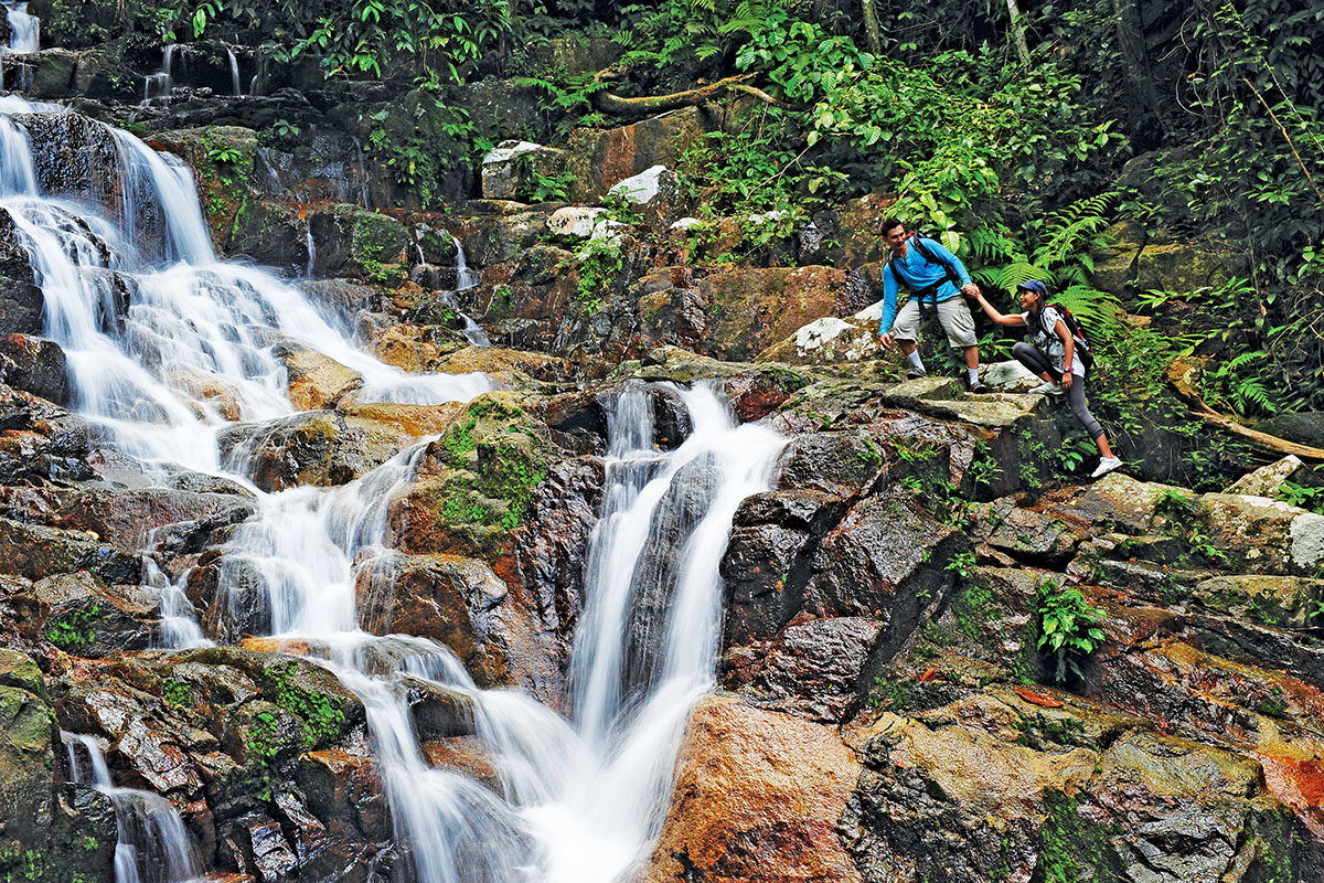
One of the finest waterfalls on Tioman Island, the Asah waterfall is located at the semi-abandoned village of Kampung Asah off Mukut village and offers breathtaking views from the top. A beautiful cascade drops into a pool hemmed in by granite slabs, the waterfall is nestled within the lush greenery of Tioman’s rainforest. Often included in the itinerary of tour packages from speedboat operators and hotels, visitors can access the waterfall park via the jungle trail from Mukut.

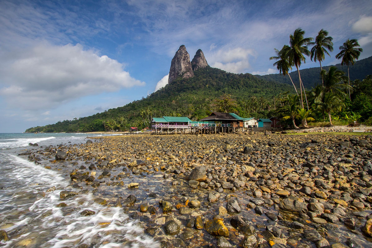
The famous Dragon Horns or Twin Peaks of Gunung Semukut, a mountain at Mukut Village, is Pulau Tioman’s most striking natural landmark. These two giant monoliths tower over the south coast of Tioman at approximately 700 meters high, with sharp pinnacles that resemble the horns of a dragon. One of Malaysia’s most sought-after rock climbing destinations, a trail begins from the base at Mukut Village and splits into different routes to attack different points of the mountain.

The Juara Turtle Project or JTP is a sea turtle conservation centre at Juara Village, providing education to locals and visitors on the eco-management of this endangered marine species. The centre also runs a volunteer programme complete with half-board accommodation to help with patrols, research, repairs, cleaning, tour guiding, and turtle egg collection, incubation and release of hatchlings. Turtle nesting season lies between March and October; during this time, JTP volunteers roam around the island for wild nests, collect the eggs and transfer them to a hatchery for incubation. The babies are released to sea when hatched successfully. During the day between 10 am and 5 pm, the centre organises a guided conservation talk at a donation fee of MYR10 per pax.

TAT or the Tengku Arif Temenggung Turtle Sanctuary is a turtle hatchery and conservation centre at Tekek Village, located along the gravel trail to Paya Village after the Berjaya Tioman Resort. Hidden on a beautiful secluded beachfront at Teluk Sri Intan Bay, the sanctuary comes under the royal patronage of Pahang together with the Department of Fisheries Malaysia. Currently, volunteers from the Juara Turtle Project collect the eggs laid during nesting season between March and October, transport them to their incubation site at Juara, and then release them back here once hatched. Visitors are free to visit and enjoy the beach at all hours but should be mindful to keep it clean.

Travel Bucket List: Malaysia Part 12 – Pahang Part 2

Pekan
Pahang’s royal capital, Pekan’s name comes from a flower, the Bunga Pekan. It is the home of the state’s royal family headed by Sultan Abdullah of Pahang and also the hometown of Malaysia’s second Prime Minister of Malaysia, Tun Abdul Razak Hussein, and his son, the sixth Prime Minister, Datuk Seri Najib Razak, both of whom were Members of Parliament from Pekan.

According to local lore, a flowering plant named Bunga Pekan used to grow wild along the banks of the Pahang River, and the town was named after it. The flower is said to be white like jasmine, though this particular plant species is also said to have become extinct. The river at Pekan town is also called Pekan River, however, there is no evidence that Pekan derived its name from this river. Other sources say the name Pekan came from Pekan Sehari or Sunday Market which still exists today, and the word Sehari was eventually omitted and the locals simply called it Pekan.

Pekan is thought to have been in existence since the time of the old Pahang Kingdom. The old name was Inderapura, although it was also commonly known by the short form Pura, which some Malays called Pekan. The old capital was located on both the left and right banks of the Sungai Pahang and the Sungai Pahang Tua up to Tanjung Langgar. The town was divided into Pekan Baharu and Pekan Lama, New and Old Pekan respectively, and the old name for Pekan Baharu used to be Kampung Cina. During the late 19th century, relations between the sultan and local villagers were close. The villagers at Kampong Mengkasar, about one km from Pekan in the direction of Kuantan, are said to be direct descendants of Tok Tuan from Makassar in Sulawesi, Indonesia.

Pekan Lama which means Old Pekan is situated on the banks of Sungai Parit which flows to Sungai Pekan. Early settlement of shops first started here and the original wooden structure of these shops can still be seen today around Pekan Lama. Istana Pantai was once located here, but it is no longer around and the site is now occupied by the Majlis Agama Islam Daerah Pekan building. Bangunan UMNO Pekan Lama is situated nearby and had been on that site since the 1960s.

The Sultan Abu Bakar Museum displays many artefacts which are important in the state’s history and the local Malay culture. The museum was officially opened by Sultan Ahmad Shah in October 1976 and is located in the former residence of the British Resident, built in 1929. It was acquired by the Sultan of Pahang in 1948 and renamed Kota Beram Palace. In 1965, the Sultan moved his residence to a new palace, the Abu Bakar Palace, where the current Royal Palace is situated.

The museum was officially opened to the public in October 1976, in conjunction with the birthday celebrations of the Sultan of Pahang. The museum expanded its collections of artefacts very actively up to 1997 and the locals surrendered and provided as gifts certain unique artefacts to the museum. One example is a keris, a type of Malay dagger, which was found by a young man in a river about 20 km from Pekan. This particular keris drew a lot of attention, coupled with strange stories of its mystical prowess and is still on display at the museum. The museum has dedicated galleries focusing on water transportation, and the personal belongings of the late Sultan Abu Bakar and the late Tengku Ampuan Pahang Tengku Afzan. The museum is open from Tuesday to Sunday between 9 am and 5 pm.

An old mosque from the 1930s, now renovated into a museum, the Muzium Masjid Sultan Abdullah is located by the Pahang River and is the country’s first mosque turned museum. The museum is divided into three thematic zones and is popular for its stunning Moorish architecture. The museum showcases symmetry and repetition in architecture with a long rectangular pool in the museum at the front making the ambience even more serene. Visitors can experience Malaysian heritage through the displayed artefacts, graphics and illustrations, calligraphy, and floor tiles pattern. The museum is open from 9:30 am to 5 pm.

Pekan is home to the Chiefs’ Rest House. This wooden structure was completed in 1926 and is a must-visit site in Pekan. It was originally built by the British as a guest house for the Chieftains in Pahang who visited Pekan to attend meetings and events at the Istana. Today, the Chiefs’ Rest House offers good, clean and reasonable accommodations to travellers. Most of the furniture in this building was brought over from the Istana. It is advisable to reserve the room in advance, as it can be packed during school holidays, weekends and whenever there are functions in the Istana. The Chiefs’ Rest House is located along Jalan Istana Abu Bakar in Pekan along the road approaching the Istana area.

The Royal Pahang Silk Weaving Centre is located in Palau Keladi village and visitors can witness the process of weaving silk and understand the art of weaving silk here. A perfect destination to understand Malaysian fabric, the Royal Pahang Silk Weaving Centre has a large collection of fabrics suitable for both formal and informal events. Existing for more than two centuries, only the cultural village of Palu Keladi practices the traditional weaving methods of silk, passed from one generation to the other.

The Pekan Riverfront is a beautiful public park that faces the Pekan River. Situated close to Jalan Sultan Ahmad, the public park also houses food stalls and gazebos and is dotted with rows of coconut trees. While the park surroundings and the blissful Pekan River are a true treat to the eye, the beautiful arch-shaped structure that is constructed at the entrance further accentuates its beauty. Short cruises also occasionally operate here. One can also indulge in fishing at the Pekan Riverfront. The stretch by the river bank from the Abu Bakar Royal Mosque heading towards the Sultan Abu Bakar Museum is Pekan’s Heritage Route.

Lake Chini, better known locally as Tasik Chini is a series of 12 freshwater lakes and is Malaysia’s second-biggest natural freshwater lake. Home to hundreds of species of flora and fauna, Lake Chini sprawls over an area of 12,565 acres and is inhabited by the Jakun branch of the Orang Asli tribe of Malaysia. It is also one of the UNESCO Biosphere Reserve sites in Peninsular Malaysia. The lake is about 70 km from Pekan. Chini River, which drains from the lake, flows into the Pahang River. The river is dammed to maintain the lake’s depth during the dry season. However, this has disrupted the natural ecology of the lake and caused the death of trees on its shores due to elevated water levels.

The lake is endowed with a rich bio-diversified lush tropical wilderness that is home to 138 species of flora, 300 species of non-aquatic life and 144 species of freshwater fish. Between August and September, the lake is transformed into a floating garden with thousands of white and pink lotus flowers covering the surface. The lake is steeped in myths and legends that have remained unexplained to this day. According to an Orang Asli legend, the lake is inhabited by a dragon called the Naga Seri Gumum, sometimes referred to as Malaysia’s Loch Ness Monster. It is believed that there is an ancient sunken Khmer city at the bottom of the lake.

Bukit Ketaya, a hill next to the lake is the site of iron ore mining. The Orang Asli who live on the banks of Tasik Chini complain that the lake has become polluted. Fish caught in the lake have become unfit to eat and the Orang Asli people cannot go to areas to collect roots used in traditional medicine because the areas have been closed for mining. In 2021, the government announced an end to mining around the lake. Lake Chini also features a resort with a restaurant, jungle trekking paths and a boat station. Boat trips are available by various routes around the lake. Prices differ according to the chosen routes which are between 45 minutes to 3 hours.

Nearby the Royal Pahang Polo Field is a long-established Islamic college, known as Kuliah Sultan Abu Bakar or the Sultan Abu Bakar Kulliyyah. It has produced eminent scholars all over the state and Malaysia. Its students consistently further their studies at the Al-Azhar University in Cairo, Egypt. Other places of interest include the Royal Palace or the Sultan Abu Bakar Palace, the Sultan Haji Ahmad Shah Mosque, the Royal Mausoleum, the Royal Pahang Polo Field close to the Palace, the Royal Pekan Golf Club, the birthplace of late Tun Abdul Razak at Kampung Pulau Keladi and the Pahang Royal Silk Weaving Centre.

Sungai Lembing
Located about 26 km northwest of Kuantan, Sungai Lembing used to contain the world’s deepest underground tin mines. There is an interesting Tin Museum in the former mining town and just north of the Tin Museum is a hanging bridge, known as Jambatan Bergantung. Access to the bridge is via a narrow, winding road at the base of the entrance to the Tin Museum. There is another hanging bridge on the outskirts of the town that is visible from the main road. Panorama Hill which provides an impressive pre-dawn view is also close-by. On the Kuantan-Sungai Lembing road at the hamlet of Pancing, there is a limestone mountain which houses a large reclining Buddha in one of its caves, known as Charah Cave. The highest peak, Gunung Tapis, also can be accessed from here. In Malay, Sungai means river and Lembing means spear.

Source

Rainbow Waterfall is a dreamy spray-like 30-meter fall offering a lovely view of a rainbow in the morning hours. Accessible via an easy 45-minute hike, at the fall, the water flows at a very low speed and the sunlight hitting the waterfall leads to the formation of the rainbow. It is visible usually between 9 and 11 am. Known as the largest multi-tiered waterfall in Peninsular Malaysia, the Sungai Pandan Waterfall is located in Hutan Lipur Sungai Pandan, a forest reservation area. It is considered the most beautiful fall in Malaysia with a suspension bridge over the natural pool offering amazing views of the falls cascading down the rocks. The Berkelah Falls is a magnificent 7-tiered waterfall. While it’s advised to be extra careful on the hike to the upper falls, those wishing for adventure can always try and get to all the tiers, swim at all the base pools and conquer the falls with a picture at each tier. The water is quite cold and the current can get strong.

Offering spectacular views of Sungai Lembing and the distant hills, Bukit Panorama makes for a hill worth climbing. Around 1100 steps on cemented staircases and hand railings in between and one is on top of the 271 meters high hill with a gorgeous view of a blanket of clouds shielding the town. It will take around 15-60 minutes depending on the stamina to climb the hill. The Mount Tapis Nature Park promises an adventurous visit here with its jungle treks, camping sites and hot springs with the rivers perfect for fishing.

Deerland Park is a privately owned deer park housing over 30 Indonesian deer, rabbits, peacocks, ostriches, Bengal cats and a Burmese python. The park is a good place to visit with kids. Open between 10:30 am and 5:30 pm, entry fees to the park is RM 5 for adults and RM 3 for children under 12 years.

The Sungai Lembing Tin Mine is the biggest underground tin mine in the world measuring as long as 322 km. The tour through the mines will give visitors a chance to experience a time when tin mining was in full swing. Starting with a ride on a tram, similar to the ones used by miners, the tour involves exploring the mines on foot after the ride.

Muzium Sungai Lembing is a museum that throws light on the illustrious tin mining era of Sungai Lembing. Overlooking the Kenai River, the colonial architectural building houses more than 100 tin-related mining equipment. The museum is open daily from 9 am to 5 pm and the ticket is RM 5 and RM 2 for Non-Malaysian adults and children respectively. Crystal House displays a collection of over 3000 crystalline stone pieces. These pieces have been collected by an ex-tin miner, Mr Lee Yon, from the Sungai Lembing Tin Mine and Panching over 19 years. It is open daily between 11 am and 6 pm and tickets are priced at RM 2 for adults and RM 1 for children.

Raub
One of Pahang’s oldest towns, Raub is historically a gold mining settlement and was founded in the 18th century. The mining town was named Raub after a group of miners found a handful of gold in every tray of sand they dug. According to one account, for every dulang of sand, there was a handful or raub of gold. Thus, the town and the district derived their name from the Malay word raub which means a scoop.

Raub became famous in the early 20th century for its gold. At that time, gold mining in Raub was operated by the Raub Australian Gold Mine, a company registered in 1889 in Queensland, Australia. The company was initially known as Australian Syndicate Ltd and later as Australian Gold Mining Co. Ltd in 1892 and operated until 1961.

The mining method used in Raub is shaft mining which started at the Raub Hole and the area is now known as Bukit Koman. A new company, Peninsular Gold, has restarted gold mining at the Raub mine. Initially, the company recovered gold from the tailings dumps from the old mine, but started mining fresh ore again in 2011. A major drilling campaign is in progress, exploring additional resources adjacent to and below the old mine.

There are a lot of British-style buildings in Raub, especially along Mason Road, now known as Jalan Tengku Abdullah. Most of the buildings in Raub were built during the pre-World War II era. Some examples of the pre-war buildings in Raub are the old Police Station of Raub built in 1906 and the Raub District Council Building.

After the gold mines were depleted, the main economic activity of Raub is agriculture. The durians grown in Raub are probably the best in Malaysia and the town is styled as the durian capital of Malaysia attracting a steady stream of visitors, especially tourists from Singapore and China.

The Lata Jarum Waterfalls is a perfect spot for family outings offering a small trek in the forest reaching the cascading waterfalls while one can hear the forest creatures. Pulau Chekas is an ideal place for a recreational weekend and stands as an island when the river gets divided into two loaded with slides for kids and relaxing activities for adults. It is also a home to Fraser’s Hill which is well-known for its extensive birdlife and deserves a visit.

One can also plan a visit to Lata Lembik Recreational Park for adventurous and exciting activities. The stunning recreational park is home to the popular magnificent waterfalls of the same name that have pristine blue waters. It offers several adventure and water sports like white water rafting, jungle trekking, etc and one can relax and take a swim in the pool that forms at the base of the waterfall.

The Lata Jarum Forest Eco Park is a traveller-friendly forest located close to the village of Dong. It is a spectacular waterfall that avalanches the rocks and forms an unstained pool in a pristine river and is a popular attraction among tourists. One can find bridges to get across small water streams and chalets inside this forest park. The toilets are close to the ranger’s office.

Taman Tasik Raub, also known as Raub Lake Park, is a gorgeous lake park located on the outskirts of Raub. The lake is surrounded by lush green landscapes and open spaces to relax, enjoy a day picnic or go fishing. Rental boats are available on site to go around the lake sightseeing and soaking in the glorious nature and calm waters.

The Tras Road Chinese Temple lies on the Raub-Bentong Road and is dedicated to Guan Yin Tang. The temple is often visited by tourists driving by Tras Road. The large red structure of this temple has 12 Chinese zodiacs, a beautiful play area for children, and a fish pond with some statues and figures. The garden area is very windy and well-designed to blend in with the temple building. It frequently hosts community events and is therefore often visited by locals. One can find souvenirs, shops and some food stalls nearby.

Travel Bucket List: Malaysia Part 11 – Pahang Part 1

Officially known as Pahang Darul Makmir or the Abode of Tranquility, Pahang is Malaysia’s third-largest state by area and the largest in peninsular Malaysia as well as the ninth-largest by population. The state occupies the basin of the Pahang River and a stretch of the east coast as far south as Endau. Geographically located in the East Coast region of Peninsular Malaysia, the state shares its borders with Kelantan and Terengganu to the north, Perak, Selangor and Negeri Sembilan to the west, Johor to the south, and the South China Sea to the east. The Titiwangsa mountain range that forms a natural divider between the Peninsula’s east and west coasts is spread along the north and south of the state, peaking at Mount Tahan, which is 2,187 m high & the famous Kuantan 188, which is 188 m high. Although two-thirds of the state is covered by dense rainforests, its central plains are intersected by numerous rivers, and along the coast, there is a 32-km wide expanse of alluvial soil that includes the deltas and estuarine plains of the Kuantan, Pahang, Rompin, Endau, and Mersing rivers.

Pahang’s capital and largest city, Kuantan, is the eighth-largest urban agglomeration by population in Malaysia. The royal capital and the official seat of the Sultan of Pahang is located at Pekan, or the old town, which was also the old state capital and was known historically as Inderapura. The head of state is the Sultan of Pahang, while the head of government is the Menteri Besar. The government system is closely modelled on the Westminster parliamentary system.

Archaeological evidence revealed the existence of human habitation in what is today Pahang from as early as the palaeolithic age. The early settlements gradually developed into an ancient maritime trading state by the 3rd century. In the 5th century, Old Pahang sent envoys to the Liu Song court. During the time of Langkasuka, Srivijaya and Ligor, Pahang was one of the outlying dependencies. In the 15th century, the Pahang Sultanate became an autonomous kingdom within the Melaka Sultanate and was centred in modern-day Pekan. At the height of its influence, the Sultanate was an important power in Southeast Asian history and controlled the entire Pahang basin, bordering to the north the Pattani Sultanate, and adjoins to that of Johor Sultanate to the south. To the west, it also extended jurisdiction over parts of modern-day Selangor and Negeri Sembilan. Pahang entered into a dynastic union with Johor Empire in the early 17th century and later emerged as an autonomous kingdom in the late 18th century. Following the bloody Pahang Civil War that ended in 1863, the state under Tun Ahmad of the Bendahara dynasty was eventually restored as a Sultanate in 1881.

In 1895, Pahang became a British protectorate along with the states of Perak, Selangor and Negeri Sembilan. During World War II, Pahang and other states of Malaya were occupied by the Empire of Japan from 1941 to 1945. After the war, Pahang became part of the temporary Malayan Union before being absorbed into the Federation of Malayas and gained full independence through the federation. On 16 September 1963, the federation was enlarged with the inclusion of new states of North Borneo, Sarawak and Singapore, which was expelled in 1965. The federation was opposed by neighbouring Indonesia, which led to the Indonesia–Malaysia confrontation over three years, along with the continuous war against local Communist insurgents.

The Khmer word for tin is pāhang, and it is phonetically identical to the old Jawi word for Pahang. Since the tin mines at Sungai Lembing were known since ancient times and the Malay peninsula was within the sphere of influence of Khmer civilization, William Linehan hypothesized that the name of the state was named after the Khmer term of the mineral. There were many variations of the name Pahang outside the Malay world. The transition from Inderapura to Pahang, approximately around the Song period, indicates that Khmer influence on the state was weakened and displaced by that of Srivijaya and Majapahit. Arabs and Europeans, on the other hand, transliterated Pahang to Pam, Pan, Paam, Paon, Phaan, Phang, Paham, Pahan, Pahaun, Phaung and Phahangh.

The Pahang River basin connects with Malaysia’s two largest natural freshwater lakes, Bera and Chini. Described as a wetland of international importance, Bera Lake was accepted as Malaysia’s first Ramsar site in 1994. The highest peak, Mount Tahan, reaches 2,187 m in elevation, which is also the highest point in Peninsular Malaysia. Pahang is home to Malaysia’s two important national parks, Taman Negara and Endau-Rompin, both located in the north and south of the state, respectively. These large primary rainforests are extensive and are home to many rare or endangered animals. Popular hill resorts located along these main highland areas are Cameron Highlands, Genting Highlands, Fraser’s Hill and Bukit Tinggi. Cameron Highlands is home to extensive tea plantations and is also a major supplier of legumes and vegetables to both Malaysia and Singapore. Pahang’s long, scenic coastline is a paradise of swaying palms and sandy beaches like Cherating, Teluk Cempedak, Beserah, Batu Hitam and Tanjung Sepat. Also located along the coastal plain is a 32 sq km wide expanse of alluvial soil that includes the deltas and estuarine plains of the Kuantan, Pahang, Rompin, Endau, and Mersing rivers. About 58 km off the coast of Pahang lies Tioman Island, an alluring holiday paradise in the South China Sea, acclaimed as one of the best island getaways in the world.

Malaysia is considered one of the most biodiverse countries on earth. Pahang maintains a protected network of managed areas rich in flora, fauna, and natural resources, despite deforestation, rapid industrialisation and an ever-growing population. Pahang has about 74 forest reserves, including ten virgin-jungle reserves and 13 different amenity forests, wildlife reserves, national parks and offshore marine parks. Of these, the Pahang segment of Taman Negara is the most outstanding. Others include the Krau Wildlife Reserve, the Bera Lake Ramsar Site, Tioman Island Marine Park and the Cameron Highlands Wildlife Sanctuary. The total forest area in Pahang is about 66% of the land area, of which 89% is a dryland forest, 10% peat swamp forest, and 1% mangroves. About 56% of the total forest is within the Permanent Forest Estate, including almost the full range of forest types found in Malaysia, although some of the more unique environments such as the heath forest or the forest on ultrabasic rocks exist only in fragmented areas of Pahang. The protected forest within Taman Negara and Krau Wildlife Reserve includes small areas of extreme lowland alluvial plains. Virtually every species of bird and mammal known from Peninsular Malaysia has been recorded in Pahang, other than a few confined to the north of the country or the west coast.

Pahang River is the longest river in the Peninsula, and from its headwaters to the estuary, it includes virtually all of the natural river types. The huge network of rivers in Pahang is home to freshwater aquatic biodiversity, which is important to the economy of the state. Connecting to this riverine system are several natural freshwater lakes, most notably the Bera and Chini lakes. Surrounded by a patchwork of dry lowland dipterocarp forests, the lake environment stretches into islands of peat swamp forests. Rich in wildlife and vegetation, the lakes provide an ecosystem which supports not only a diversity of animal and plant life but sustains the livelihood of the Orang Asal, the aboriginal people inhabiting the wetlands. Most of the coastline is sandy, with rocky headlands at intervals. Mangroves and nipah swamps are confined to estuaries and do not occur along the exposed coast. There are many islands off the east coast, the largest being Tioman and Seri Buat islands. Besides the island populations of fauna and flora, which sometimes differ genetically from mainland forms of the same species, these islands are of value for the reefs and other bottom features which support marine biological diversity. Tioman, Chebeh, Tulai, Sembilang, and Seri Buat islands constitute the Tioman group of islands within the Marine Parks system of Peninsular Malaysia.

Modern Pahang is an economically important state with main activities in the services, manufacturing and agricultural sectors. Over the years, the state has attracted much investment, both local and foreign, in the mineral sector, including iron ore, gold, tin and bauxite. Malaysia’s substantial oil and natural gas fields lie offshore in the South China Sea. At one time, timber resources also brought much wealth to the state.

Historically, by the 19th century, Pahang’s economy, like in ancient times, was still heavily dependent on the export of gold. Gold mines can be found from Bera to the Jelai River River basin. Systematic mining started in 1889 during the British protectorate when the Raub Australian Gold mine was established. Extensive underground mining took place in the area, and this continued until 1985, during which time the mine at Raub produced nearly 1 million ounces, 85% of the production of Peninsular Malaysia. Tin was also mined on a large scale with production primarily concentrated at Sungai Lembing, where during its heyday, the operations saw the excavation of deep shaft mines that were among the largest, longest and deepest in the world. The growth of the mining industry had a significant impact on Pahang’s society and economy towards the end of the 19th century. Thousands worked in the mines, which became an important trading centre in the state. Today, the mining industry, along with quarrying, only accounted for 1.6% of the total state GDP in 2016. Pahang accounts for more than 70% of Malaysia’s estimated 109.1 million tonnes of bauxite reserves. The services sector, which constitutes 49% of the total Pahang GDP, is primarily driven by the wholesale and retail trade, food and beverage and accommodation while manufacturing accounts for 22% of the state economy and tourism contributes approximately 26% of the overall state economy.

As a less ethnically diverse state, the traditional culture of Pahang is largely predominated by the indigenous culture of both Malays and Orang Asli. Both cultures trace their origin from the early settlers consisting primarily various Malayic-speaking Austronesians and Mon-Khmer-speaking Austroasiatic tribes. Around the opening of the common era, Mahayana Buddhism was introduced to the region, where it flourished with the establishment of a Buddhist state from the 5th century. Malayic cultures flourished during the Srivijayan era, and Malayisation intensified after Pahang was established as a Malay-Muslim Sultanate in 1470. Pahang Malays share similar cultural traits with other sub-groups of Malay people native to the Malay peninsula, in particular, closely affiliated to the people of the east coast of the peninsula like Thai Malays, Terengganu Malays and Kelantanese Malays. The cultural features of the Orang Asli are represented by significantly diverse tribal identities. Before 1960, the various indigenous groups did not consciously adopt a common ethnic marker to differentiate themselves from the Malays. The label Orang Asli itself historically came from the British. Each tribe has its language and culture and perceives itself as different from the others. This micro identity was largely derived spatially from the geographical area they traditionally settled. Their cultural distinctiveness was relative only to other Orang Asli communities, and these perceived differences were great enough for each group to regard itself as unique from the other.

Kuantan
The capital of Pahang, Kuantan is located near the mouth of the Kuantan River. It is the 18th largest city in Malaysia and the largest city on the East Coast of Peninsular Malaysia. The administrative centre of Pahang was officially relocated to Kuantan on 27 August 1955 from Kuala Lipis.

During the first century, Kuantan was a part of the Chih-Tu empire. In the 11th century, the land was conquered by another small empire called Pheng-Kheng before being taken over by the Siamese during the 12th century. During the 15th century, Kuantan was ruled by the Malacca Empire.

Kuantan is said to have been founded in the 1850s. In its early days, it was known as Kampung Teruntum or Teruntum Village. The village was situated at the mouth of the Teruntum River, which is in front of the current hospital, and it was established by Haji Senik and his followers in the 1850s. Early primary economic activities included fishing and small businesses. The main evidence of the establishment of the village is the cemetery that is situated near Taman Esplanade in front of the current Hospital Tengku Ampuan Afzan. Towards the late 19th century, the arrival of Chinese miners and traders saw the establishment of a township in Kuantan and nearby tin mining areas such as Gambang and Sungai Lembing. Similar to what occurred in other states in Peninsular Malaysia, rubber plantations attracted Indian settlers as well. The sinking of HMS Prince of Wales and HMS Repulse took place off the coast of Kuantan on 10 December 1941. Kuantan was declared a full-fledged city by Sultan Abdullah of Pahang on 21 February 2021, and its town council was officially renamed the Kuantan City Council or MBK.

One of Kuantan’s major economic activities is tourism. Domestically, it is famous for the production of handicrafts, batik, keropok or dried fish crackers and salted fish. The timber industry, the ice cream and the fishing industry also play major roles in the local economy.

Kuantan is famous among locals and tourists for its fish crackers called keropok in Malay and salted fish, where the fish is marinated mainly with salt and left out to dry in the sun for days and sold at the market, Serambi Teruntum in Tanjung Lumpur.

Also known as Palm Beach, Teluk Chempedak is Kuantan’s main sightseeing attraction. It is a beautiful white sandy beach located 5 km from Kuantan. The boardwalk here offers amazing views of the beach with the jungle on the other side and connects to Missionary Beach. Geologically, Chempedak Beach is quite special since it witnessed volcanic activity a long time back. This led to the formation of three-layer rocks made up of basalt, dolerite and granite. The beach also has a bunker dating back to World War II. For children, there is a playground equipped with decent playing facilities. The beach is ideal for jet-skiing, surfing and swimming. Swimming is strictly forbidden during the monsoon season between November and February. A 24-hour open convenience store known as 7-Eleven is located at the beach that also has toilet facilities. Other popular scenic beaches in the city’s vicinity include Batu Hitam, Balok, Chenor, Pantai Sepat, Beserah, and Cherating. Near Cherating, there are turtle sanctuaries, and a few kilometres away from Cherating is Pulau Ular or Snake Island.

Located about 10 km from Kuantan, Pantai Batu Hitam or the Black Rock Beach, is a beach with white sands and black volcanic rocks. The beach is famous not only for its unique rocky, sandy surface but also for its therapeutic benefits and calming surroundings. For the ones looking for some fun activities to indulge in, Batu Hitam has a batik workshop as well as various sports activities to participate in. There are several resorts around the beach which offer spa facilities with natural ingredients and minerals extracted from the cleansing volcanic rocks.

Taman Gelora, is one of Malaysia’s most beautiful seaside parks. It is widely popular because of the scenic view, a natural jogging path, a huge playground and a magnificent pond with blooming water lilies. One of the major attractions at Taman Gelora is probably the daily 10,000-step challenge which not only allows the visitors to get into good health in a fun way but also takes them through the various parts of this beautifully created park and gives them the perfect escape from the hustle and bustle of life.

Taman Esplanade is a 1-km-long paved walkway and public space along the Kuantan River at Jalan Besar. People come here for a walk along the river while enjoying the gentle breeze of the sea. Lined with palm trees, Taman Esplanade stretches from Shahbandar Jetty to Mega View Hotel. The walkway is well-lit with lamp-posts, and many people come here for jogging and exercising. A great spot for fishing, Taman Esplanade also has a children’s playground with swings, slides, see-saws and other playing facilities for kids to enjoy their time here while you take a rest on the benches. In the middle of the Esplanade, one can find a food court with local delicacies.

The beautiful Taman Bandar is a recreational park providing a mesmerising lake view along with housing proper jogging pathways and exercising areas. Situated in front of the Kuantan Immigration Office, the best time to visit is before 6:30 pm to experience scenic beauty. To relax and destress, one can feed fish in the lake or grab some snacks from nearby restaurants.

Kuantan is known for its waterfalls. The most well-known is the Sungai Pandan Waterfall, located about 25 km from the centre of Kuantan and also known as Panching Waterfall; this 100 m high majestic waterfall is part of Sungai Pandan under one of Malaysia’s Forest Reservation Area. There is a fish spa near the waterfall, which is the perfect antidote to a stressful life. The waterfall makes for a great picnic spot. The suspension bridge near the falls allows visitors to get amazing views of the waterfall. Visitors are allowed to swim in the pool located at the bottom of the waterfall, as its shallow depth makes it a child-friendly place. One can also try their hand at barbeques as there are designated barbeque grill areas in the reserve. Visitors are also free to explore the trails leading up to the waterfall or buy some souvenirs from nearby stalls. The waterfall is open between 9 am to 5 pm on Mondays to Thursdays and is between 9 am and 6 pm on Saturdays and Sundays. It is closed on Fridays. Other waterfalls near Kuantan include the Sungai Berkelah Waterfall and the Jerangkang Waterfall. One can also go on a river cruise on the Kuantan River from the small jetty there.

Also known as Sultan Ahmad Shah State Mosque, the Masjid Sultan Ahmed Shah mosque is the state mosque of Pahang. Seen from afar, the mosque looks magnificent, especially when lit up at night. The first structure and style of the mosque were that of a big dome with a minaret. However, this construction style started having serious leakage problems during the rainy season. In 1992, the mosque was demolished, and a new mosque with a new design consisting of four rocket-like minarets with a large dome encircled by four smaller domes was constructed, and the new mosque was reinaugurated in 1994. The mosque is surrounded by a huge open green area and is built in Ottoman-Moorish Islamic architectural style. The mosque is spacious from the inside and has a huge hall which is big enough to accommodate eight thousand people at any given time. The mosque is open between 5 am and 10:30 pm daily.

Dedicated to the Supreme Patriarch of Taoism, the Lao Zi Temple is located along the Kuantan-Sungai Lembing road. Its 823 meters long Golden Dragon Structure is the main attraction, with it being listed in the Malaysia Book of Records as the country’s longest dragon statue. Inside the dragon walls, a 5000-word scripture, Book of Tao & its Virtues, is written. At the exit, one will come across a ball called the Dragon’s Pearl. It is believed that touching the ball brings good luck. The temple compound features many statues of Chinese zodiac creatures, deities and a 7-meter-tall statue of Laozi himself. To reach Lao Zi Temple, one will have to walk inside the dragon structure by entering through its tail and then emerging out of its mouth. If one chooses to walk through the dragon to reach the temple, the ticket is RM 5, but if they take the shortcut by climbing the stairs, they’ll have to pay RM 3.

The Taman Negara, which is around 130 million years old, is a rainforest that boasts of being the oldest one on Earth. The national park covers an area of 4343 sq km and is renowned not only for its rainforest but also for its birds and insects. Visitors can traverse the longest rope walkway in the world and enjoy birds and animals in their natural habitat. At the rainforest, one can climb Teresk Hill using one of the two trails leading up to the 334-meter high hill. The boardwalk route along the east of the river is relatively easy to walk on, while the route to the west is tougher and leads through muddy paths full of leeches. But the upside of this trek is the variety of wildlife one can see on the way up. The canopy walk on the suspension bridge on Bukit Teresek is the longest in the world at a height of 530 meters. Taman Negara offers treks of various lengths, which can last up to 9 days, and visitors are free to choose whatever suits them the best according to their previous trekking experience and expertise levels. Visitors can also visit Orang Asli settlements in the rainforest. Orang Asli translates to original people in Malay, and many settlements belonging to the Orang Asli lie along the trail, some of which can only be reached via a short boat ride. Visitors can opt for a night walking safari or a night 4WD Safari and view nocturnal plants and animals. Other than these, visitors can also opt to fish, explore caves, bird watching, mountain climb or camp at the national park.

A must-visit at Taman Negara is the Lata Berkoh and waterfall cascades. The waterfall is a popular spot for swimming, with a boat ride for RM 160. On the way up, one should visit the Kelah Fish Sanctuary. The national park also plays videos on flora and fauna, which are shown in the Interpretive Room at 9 am, 3 pm and 5 pm daily. The best time to visit the park is between February and September, when it is the dry season. However, many visitors visit between April and August, which happens to be the tourist season.

Kuantan 188, previously known as Teruntum Tower is a 3-story, 188-meter-tall tower, Malaysia’s second-tallest tower after the Kuala Lumpur Tower and the second-tallest in the East Coast Economic Region after the newly completed Grand Ion Majestic in Genting Highlands, which is Pahang’s tallest building. Its construction was started in August 2017 and completed on 3 September 2019. It features an observation deck at 92 m, a restaurant at 98 m and an open sky deck at 104 m. The tower offers a 360-degree view of Kuantan River and Kuantan City. The design of the tower was inspired by the spearhead which is one of the elements on Pahang’s Coat of Arms while the tower’s porch is inspired by the Lumnitzera Tree. The tower’s porch symbolises the diversity of the people of Kuantan and Pahang. The five connected steel posts of the spire represent the five principles of the Rukun Negara as the core of people’s unity. It also represents the five Pillars of Islam. The golden tower’s pinnacle symbolises the sovereignty of the Sultan of Pahang.

Gua Charas is a limestone cave formed millions of years ago and holds great religious importance for both Hindus as well as Buddhists. This temple cave is located inside a limestone hill known as Bukit Charas and is located around 25 km northwest of Kuantan. The 400 million-year-old granite and limestone massif reaches 355 meters in height and is dotted with symbols and statues of Hinduism and Buddhism. Inside the temple cave, one can find an idol of the Sleeping Buddha, as well as the Jala Lingam, which represents the Hindu deity, Lord Shiva. Other than the main temple cave, one can also explore other open-sided caves located further up on the mountain.

After the car park, visitors should climb up to the mouth of the caves. They should take the stairs that lead up to the cave. The insides of the cave are untidy, and the walls are of a greenish hue because of the moss. After climbing the first 100 cemented steps or so, one reaches the lower cave. Inside one of these caves is the famous statue of the reclining or sleeping Buddha. The cave is lit up beautifully, and other than the statue, there are some notable rock formations in the cave. These include formations that resemble the goddess Kwan Yin, a fish, a nostril, a royal tombstone, an elephant and a combing princess. Further ahead, there are various other caves with openings. Inside one of these caves is a black pillar which is known as Jala Lingam, which represents Lord Shiva. From here, one can get a bird’s eye view of the plain and Kuantan. One of the cave walls also features some graffiti that is around forty-seven years old. Interestingly, this graffiti is considered to be more of heritage than vandalism, given that it has existed for such a long time now. The odour of bat droppings can be quite overwhelming, so those with allergies should refrain from visiting Gua Charas. It is also to be noted that all visitors should be free from any allergy related to limestone also. Heart patients and claustrophobic people should indulge in only limited activities at the cave. The cave is open between 8:30 am and 5 pm daily and has an entry fee of RM 2 for adults and RM 1 for children.

Travel Bucket List: Malaysia Part 9 – Negeri Sembilan Part 2

Port Dickson

A beach resort and the second largest urban area in Negeri Sembilan after Seremban, Port Dickson is named after the British officer, John Frederick Dickson in 1989 and is a favourite weekend getaway for those from Seremban, Port Klang and Kuala Lumpur and even Singapore. The town is known for its high-end hotel establishments, army bases, pristine beaches facing the Strait of Malacca, and a lot more.

The town used to produce charcoal and therefore was called Arang which in Malay means charcoal. There used to be a carbon mine at the first mile of the coast road which was named Jalan Pantai, but was later developed as a small port by the British during the Straits Settlement period. Port Dickson was also known as Tanjung which means a Cape in Malay, alluding to the town centre’s location on a small peninsula. The oldest shophouses were the four situated presently at Jalan Lama.

Historically what is today Port Dickson and nearby Lukut were then part of the Luak of Kelang, one of the original nine chiefdoms or luaks that formed the first iteration of Negeri Sembilan in 1773. By the early 1800s, it was then part of Selangor. On 30 July 1880, a meeting was held in Singapore between Sultan Abdul Samad, then Sultan of Selangor, Raja Bot, the ruler of Lukut district, Dato’ Kelana of Sungai Ujong as well as the British, in which Selangor ceded the district of Lukut to Sungai Ujong which later became the modern-day Negeri Sembilan.

Tin ore was plentiful in Lukut, an area within the Port Dickson district, during the 1820s, and it attracted Chinese immigrant miners. The British considered the area to have great potential as a harbour and it was intended to supersede the port in Pengkalan Kempas. The officer in charge was named Dickson, and the town was named Port Dickson after him. Others claim that Sir John Frederick Dickson, colonial secretary, and a senior official of the Federated Malay States founded Port Dickson and Pulau Arang in 1889. Soon Port Dickson evolved into a busy trading centre and railways were constructed to facilitate the growth and development of the town. Although Port Dickson experienced rapid development, its beaches are fairly well preserved.

Port Dickson, as a resort town, thrives primarily on tourism, but other sectors also contribute to the town’s economic growth. Along with Seremban, Port Dickson is part of the 1530 sq km Malaysia Vision Valley, a growth corridor initiated by the state government which aims to develop the western half of Negeri Sembilan to complement the existing development in the neighbouring Klang Valley and the Greater Kuala Lumpur area. Port Dickson has two refineries which make significant contributions to the local economy.

A former mining town, most attractions in Port Dickson are concentrated around the coast – the beautiful beaches of Pantai Cahaya Negeri, Tanjung Tuan, Teluk Kemang, Saujana, and Bagan Pinang present a host of adventures and fun for families and adrenaline junkies. The 18 km long beach from Tanjung Gemuk to Tanjung Tuan is a holiday destination for locals, especially those who come from the Klang Valley. Many Singaporeans have invested in holiday homes in and around Port Dickson and over the years, many hotels and resorts were opened to capitalise on the tourist draw. In the 1990s, Port Dickson boomed with new hotels and resorts being planned and constructed. Due to the Asian financial crisis of 1997, however, many of these projects stalled, leaving many unfinished buildings scattered along the Port Dickson coastline. While some of these half-constructed resorts are still abandoned, with the improving economy of the 2000s, many of the projects were eventually revived and completed.

The newer five-star Admiral Marina & Leisure Club has good dock facilities for yacht travellers, sailboats and luxury cruisers and is a transit point for racing sailboats joining the Raja Muda Selangor International Regatta, the Royal Langkawi International Regatta and Thailand’s Phuket Kings Cup regattas.

Lying about 17 km south of Port Dickson right before Cape Rachado, the Blue Lagoon is a compact yet quite popular beach in the area. Locally referred to as Tanjung Biru, the beach is surrounded by a dense cover of hills and vegetation which makes the beach stand apart. Due to its proximity to the Tanjung Tuan Forest Reserve, wildlife sightings especially migratory birds, monkeys and squirrels are a common sight in this region. The water at the beach remains calm and is shallow which makes it safe for kids to play around in. This also makes for a great location for water sports. Hidden under the beach water lie several coral reefs which add to the ambience of the beach and are an attraction for divers. Blue Lagoon Beach also accommodates several market stalls, food vendors and a hawker centre which make it a great picnic spot. The best time to visit the beach is on a weekday between 10 am and 5 pm.

Located on a coastal strip between the 5th and 6th mile of Port Dickson, about 8 km away, Cahaya Negeri or Pantai Cahaya Negeri is a white-sandy gleaming beach. This shimmering beach features an artificial cape with a recreational park that accommodates some soothing picnic spots. This crowd-pleasing venue is quite popular for its phenomenal sunset views. There is a beautiful wooden bridge called Lover’s Bridge constructed on the eastern edge of the beach’s entrance which is a wonderful spot to take photographs and the bridge leads you to Pulau Burung or Bird Island a coastal mangrove area. On this island, there’s a wonderful watchtower which offers a jaw-dropping view of the coastline of Port Dickson. Activities like camping, hiking, water sports, boating, fishing, and barbeques can be done at the beach. There are public toilets available here which charge between 50 sen to RM 1.

Located on the 7th mile of the Port Dickson coastal road, Wan Loong Chinese Temple is a Buddhist Chinese Temple. Wan Loong means the Dragon of the Clouds and has been built to honour several deities including the Monkey King and Kuan Yin or the Goddess of Mercy. The temple has an aesthetic colourful appeal with its traditional architecture comprising carved Chinese motifs and dragons. The fortress wall of the temple and the pools full of colourful fishes and a giant turtle are its exclusive features. There is a tortoise in the temple pond which is believed to bring good luck when visitors touch it. It is recommended to visit the Wan Loong Temple between 9 am and 1 on to avoid excessive crowds.

Sri Anjaneyar Temple is a temple dedicated to the monkey god, Lord Hanuman and is quite famous owing to the mystical stories attached to it. It’s believed that the Hanuman statue placed in the shrine had itself turned its head to face the town of Rameswaram in Tamil Nadu in India. The head-shifting occurrence is said to have happened in 1996 when a foreign photographer was clicking pictures of the shrine. And when he returned to click some more shots, he was shocked to see the change in the position of the idol’s head. Some believe that due to the strong bond that Lord Hanuman shared with Lord Ram, the idol turned its head towards Rameswaram. According to others, the idol turned its head because Lord Hanuman was against the meat and alcohol that was originally offered in the temple. The temple is open daily, from 7:30 to 9 am and then again between 7:30 to 9 pm.

Cape Rachado is an enclave of the state of Malacca about 18 km from Port Dickson. It is the  Portuguese name for Tanjung Tuan and is the only coastal forest in Malaysia. Cape Rachado was declared a permanent forest reserve by the Forest Department of Melaka in 1921 and was also gazetted as an International Bird Area and a Wildlife Sanctuary. The forest reserve attracts bird watchers from all over and is visited by more than 300,000 migratory birds and more than 177 species of flora. It is well known for its iconic Cape Rachado Lighthouse. It’s a great place for visitors who want to experience the evergreen forest and the beautiful ocean in the same place. The Cape Rachado Lighthouse was built by the Portuguese in 1511 and was used to guide ships along the Straits of Melaka. It was rebuilt in 1863 and offers a spectacular view of the sea and the Straits of Melaka. With a height of 24 meters, the masonry tower is accessible only by foot and is located in an enclosed woodland, which makes it a perfect spot for bird watching. March would be the ideal time to visit Cape Rachado as the Raptors Watch takes place during this time of the year. The morning hours of the day are usually the ideal time to visit the place as it’s cooler. There is an entry fee of RM 1 to access the place.

The Lukut Fort and Museum is a historical recreational site in Port Dickson. The fort was built in 1847 by Raja Jumaat and is in ruins today. Its antiquities are displayed in the Lukut Museum which was built in 1999. Located 6 km from Port Dickson, the Lukut Fort and Museum is now a recreational historical site with a park and gazebos maintained by the government. The entrance is free to the fort and museum. The museum is situated in a former bungalow of a district officer. This double-storey building has 4 galleries housing artefacts relating to the local history dating back to the tin mining era, culture and traditions. One of the artefacts on display includes a Portuguese bronze canon from a shipwreck during the Battle of Cape Rachado. Other displays include pottery shards, stoneware plates, porcelain belonging to the Qing Dynasty and clay floor tiles. Gallery C & D are temporary exhibition galleries displaying exhibits relating to different themes every year. The fort and museum are open between 9 am and 6 pm and entrance is free.

Set in two old army buildings, the Port Dickson Army Museum is dedicated to Malaysian army artefacts. Also known as Muzium Tentera Darat, it houses 9 galleries along with outdoor exhibits that trace the army from the 16th century Melaka Sultanate to the British era. One very interesting exhibit is the CPM or the Communist Party of Malaya Tunnel which has been recreated underground similar to the one used by the bandits who conducted all their activities here during the Emergency. There’s a collection of various military aircraft and helicopters, armoured vehicles, field guns, artillery pieces and a steam locomotive on display here. Another gallery focuses on the modern army and its UN peacekeeping missions. The museum has a cafe, a souvenir shop, toilets and a surau as well. The museum has free entry fees and is open between 9:30 am and 6 pm.

Home to paintings and optical illusions, the Alive 3D Art Gallery leaves visitors amused and enthralled. The paintings are three-dimensional which let the people be a part of the painting. The paintings are divided into five zones. The Wild West Cowboy Indoor Theme Park is a must-visit if one is planning to go to the gallery. The gallery is open from 11 am to 10 am on weekdays and Sundays and from 10 am to 11 pm on Saturdays. The Wild West Cowboy Theme Park is open from 12 noon to 10 pm on weekdays, 10 am to 11 pm on Saturdays and 10 am to 10 pm on Sundays and Public holidays. It is closed on Tuesdays unless it is Malaysia School Holiday or Public Holiday.

The Teluk Kemang Observatory, also known as the Baitul Hilal Complex is a modern space observatory and is one of the most reputed observatories in the region and boasts of an extensive collection of sophisticated telescopes. The observatory provides a jaw-dropping view of the Straits of Melaka and is a perfect setting for stargazing. It is a popular place for astronomical gatherings and observations. One of its telescopes, a 24-inch spectacular beauty was purchased for RM 2 million and is well known for its accurate observations. The view from the telescope is dependent on the weather and the night sky, however, visitors can even see Saturn or Jupiter on a clear day. The observatory is open between 3 and 5 pm and again between 10:30 pm and midnight.

Pusat Ikan Hiasan is a fish centre located at the northern end of Port Dickson in Teluk Kemang. The centre boasts a wide diversity of fish species and also acts as a breeding and conservation centre for marine life. It is famous for its sea turtles on display and traces their lifecycle from hatchlings to adulthood. The port is being managed by the Department of Fisheries and also holds an incubator site for commercial coral reef entrepreneurs. The market is open from 8:30 am to 4:30 pm on weekdays and is closed for a prayer break on Fridays between 12:15 and 2:45 pm. On weekends it is open from 10 am to 4 pm.

The PD Ostrich Show Farm is an ostrich farm popular for ostrich and pony rides. The show farm offers activities like petting and feeding ostriches, rabbits, horses, peacocks and guinea pigs and learning interesting facts about ostriches. Children particularly have a wonderful time at the PD Ostrich Show Farm where they get to run around rabbits and enjoy ostrich rides. The show farm has a cafeteria where one can enjoy the signature Ostrich Satay. It is open between 9 am and 6 pm every day. Entry fees are RM 15 for Malaysian adults and RM 10 for children who are Malaysian. For foreigners, adults pay RM 20 while children pay RM 10.

Kuala Pilah

Kuala Pilah lies 40 km east of Seremban. The charm of this old valley town lies in its Chinese shophouses surrounded by traditional Malay village houses built on stilts. The countryside is a breath of fresh air with clear fresh water from Mount Angsi. A wonderful dragon fruit cultivation can also be seen here with beautiful kampongs and paddy fields on the way. Kuala Pilah is also known for its Minangkabau houses with a sloping buffalo horn roofline. There are rows of small shopping outlets in the newer and central suburbs.

Located in Johol, the Batu Maloi Cave is a 2.4-kilometre-long talus cave made up of fallen boulders of granite with a river flowing through it. It is said to be the longest granite cave in Malaysia and is popular among cavers. The Ulu Bendul Recreation is one of the most popular tourist attractions in Kuala Pilah. It is situated in the Angsi Forest Reserve, compartments 45 and 52 and is about 16 km away from Seremban. The site was established in 1972 and is a fun spot to hike and trek in the jungle paths. The Martin Lister Memorial, an arch designed in Chinese fashion, was established in 1901. It is a historical site that one can visit to pay respects and commemorate the Late Martin Lister who was killed for his efforts to end the violence and conflict of the secret Chinese societies that tortured Chinese migrants. The Sikh Gurudwara Sahib and the Sri Kanthasamy Temple as well as the Masjid India are places of worship in the town.

Travel Bucket List: Malaysia Part 8 – Negeri Sembilan Part 1

Historically spelt as Negri Sembilan, Negeri Sembilan lies on the western coast of Peninsular Malaysia and borders Selangor to the north, Pahang in the east, and Malacca and Johor to the south. The state has diverse tropical rainforests and an equatorial climate with mountain ranges belonging to the Titiwangsa Mountains, a southern subrange of the Tenasserim Hills that spans throughout southern Myanmar, southern Thailand and Peninsular Malaysia, with Mount Besar Hantu as the highest point. It is the fourth-smallest state in Malaysia by area as well as the second-largest in the southern region after Johor.

The state’s name is believed to derive from the nine or sembilan villages or nagari in the Minangkabau language that is known as Luak today settled by the Minangkabau, a people originally from West Sumatra in present-day Indonesia. Minangkabau features are still visible today in traditional architecture and the dialect of Malay spoken.

Unlike the hereditary monarchs of the other royal Malay states, the ruler of Negeri Sembilan is elected and is known as Yang di-Pertuan Besar instead of Sultan. The election of the Ruler is also unique among all Malay states. He is elected by the council of Undangs who lead the four biggest territories of Sungai Ujong, Jelebu, Johol, and Rembau, from the legitimate male members of the Pagaruyung Dynasty, with the surviving sons of the previous Yamtuan coming first in the considerations but not being obligatory to be voted on, making it one of the more democratic monarchies.

The capital of Negeri Sembilan is Seremban and the royal capital is Seri Menanti in Kuala Pilah. The Arabic honorific title of the state is Darul Khusus or the Special Abode.

The earliest possible human settlement in Negeri Sembilan can be traced back to the Pasoh Caves, a complex of karst caves near Simpang Pertang. Some of the artefacts found around the caves include stone tools and food leftovers, estimated to be used around 12,000 BC based on carbon dating.  According to the Malay Annals, Parameswara reportedly visited the settlement of Sening Ujong, which was located in what is now Seremban.

The Minangkabaus from Sumatra settled in what is today Negeri Sembilan in the 15th century under the protection of the Malacca Sultanate, and later under the protection of its successor, the Sultanate of Johor. They also brought their matrilineal custom, known as Adat Perpatih, with them and made it the local custom. As Johor weakened in the 18th century, attacks by the Bugis forced the Minangkabaus to seek protection from their homeland. The Minangkabau ruler, Sultan Abdul Jalil, obliged by sending his near relative, Raja Mahmud, also known as Raja Melewar. When he arrived, he found that another royal, Raja Khatib had already established himself as ruler. He declared war against Raja Khatib and became the ruler of Negeri Sembilan. The Sultan of Johor confirmed his position by granting the title Yamtuan Seri Menanti or He Who is Highest Lord of the Seri Menanti in 1773.

Negeri Sembilan, at the dawn of her establishment, was originally a loose confederation consisting of nine luaks, hence the name. At the time of Raja Melewar’s accession, it used to cover a larger area than its modern-day boundaries. Besides modern-day Negeri Sembilan, it also spanned parts of what is today Selangor, Malacca, Pahang and Johor. The original nine chiefdoms or domains in 1773 that made up the first incarnation of Negeri Sembilan and gave the state its name are Sungai Ujong, Jelebu, Rembau, Johol, Jelai, Ulu Pahang, Naning, Segamat and Klang. The latter four chiefdoms were annexed into neighbouring states in the 19th century. Naning was annexed into the Straits Settlement of Malacca in 1832 following the Naning War; Ulu Pahang became the Bera region of Pahang, Segamat was annexed into Johor and Klang became the Kuala Langat region of Selangor.

After Raja Melewar’s death, a series of disputes arose over the succession. For a considerable period, the local nobles applied to the Minangkabau ruler in Sumatra for a ruler. However, competing interests supported different candidates, often resulting in instability and civil war. In 1874, the British intervened militarily in a leadership tussle in Sungai Ujong to preserve British economic interests and placed the domain under the control of a British Resident. Jelebu followed in 1883 and Rembau in 1887. The formation of modern Negeri Sembilan began in 1889, when the Seri Menanti domain, under the rule of Tuanku Muhammad, the son of Yamtuan Antah, combined with the domains of Tampin and Rembau, forming the Seri Menanti Confederation as a single political entity. The domains of Sungai Ujong and Jelebu joined this confederation in 1895, forming the state of Negeri Sembilan in its modern borders. Martin Lister became the new state’s first Resident, and Negeri Sembilan became part of the Federated Malay States the same year.

Negeri Sembilan endured Japanese occupation in World War II between 1942 and 1945, joined the Federation of Malaya in 1948, and became a state of Malaysia in 1963. In the 1990s and 2000s, Seremban and Nilai attracted people who moved in from the overcrowded towns of the Klang Valley. These two cities also became the sites of new factories and industrial parks, accelerating the development of the state into modern times. On 9 September 2009, the state capital of Seremban was approved to become a city or a Bandar Raya and Seremban achieved the status of a city on 20 January 2020.

Negeri Sembilan is composed of two vast plains divided by a mountainous spine in the middle, well-drained by various rivers, resulting in the state being bisected into two regions, namely western Negeri Sembilan consisting of Port Dickson, Seremban and Rembau Districts and eastern Negeri Sembilan, which covers the districts of Jelebu, Kuala Pilah, Jempol and Tampin. The western half seems to be more developed and has an intricate and concentrated road network compared to the latter, which is much more rural. Negeri Sembilan is a multiethnic state in which every ethnic group speaks their respective languages and dialects. The state has the highest percentage of Indians compared to other Malaysian states. The Negeri Sembilanese people speak a unique variety of Malay known as Negeri Sembilan Malay or in their native language as Baso Nogoghi. It is not closely related to other varieties of Malay in Peninsular Malaysia but more closely related to the Malay varieties spoken in neighbouring Sumatra especially varieties of Minangkabau. Besides Malays, the Chinese community also speak their languages and dialects. Orang Asli peoples like Temuans speak a language closely related to Malay. Standard Malay is widely used throughout the state.

The Minangkabau people brought along with them a cultural heritage which is still preserved and practised today known as the Adat Perpatih, a matrilineal system of inheritance and administration that is unique to the state. In this system, the husband is the head of the household and inheritance passes from the mother to the daughter. The Minangkabaus in Negeri Sembilan are divided into twelve sukus or clans. Each of these sukus is led by a chief, known as the Lembaga and each suku is broken down into subunits known as the Perut, where each of them is led by a chief, either known as a Buapak if a male or Ibu Soko if female. Both the Buapak and Ibu Soko play a vital role as people to refer to regarding the adat and religious matters among the subordinates of the Perut, known as Anak Buah. Marriage between members of the same clan is forbidden.

For the state of Negeri Sembilan, let’s work our way from the south to the north.

Source

Tampin

Bordering the state of Malacca, Tampin borders the town of Pulau Sebang in Malacca. It is also situated at the southern tip of the longest mountain range in Malaysia, the Titiwangsa Mountains. The state borders between Negeri Sembilan and Malacca is demarcated by the traffic lights across Jalan Besar, as seen from the Negri side of the town.

Tampin gets its name from the container or pouch woven from the pandanus fronds. The container was used to store condiments such as the sticky dessert kelamai or dodol and the shrimp paste, belacan.

Tampin was originally part of the district of Rembau. After the Naning War in 1832, Raja Ali declared himself the ruler of Seri Menanti and his son-in-law, Syed Shaaban, as the ruler of Rembau. This enraged other rulers of Negeri Sembilan as they had no right to the posts. In a civil war in 1834, Raja Ali and Syed Shaaban retreated to Tampin and the area from Mount Tampin to Bukit Putus was removed from Rembau. The provinces of Repah, Keru, Tebong and Tampin Tengah formed the district known as Tampin. Syed Shaaban became the first ruler of Tampin and proclaimed himself the title Tunku Besar Tampin. The district is one of the original confederations of nine states collectively known as Negeri Sembilan, which means Nine States in Malay.0

On 11 March 1889, the Governor of the Straits Settlements, Sir Cecil Smith, held a meeting with the rulers of Jelebu, Sungai Ujong, Rembau, Seri Menanti and Tampin to combine the districts to better manage them under British rule. Tampin, Rembau and Seri Menanti agreed to the proposal and were united as the Seri Menanti Confederation and the newly formed confederation accepted Martin Lister as its first British Resident. After Malaya’s independence in 1957, Negeri Sembilan and its districts started forming local administrative councils.

Source

The Tampin Recreational Park is strategically located and consists of a natural lake, along with lush greenery and various facilities such as a children’s playground, badminton courts, tennis courts and jogging tracks. Tampin Square is located within the vicinity of the Tampin Sports Complex and a local favourite. The Tampin Lake Garden is located about 400 meters from the Tampin Lay By and is equipped with a children’s playground, a look-out tower, huts, benches and jogging tracks. An 8-foot marble monument was erected on the Kelamah River to commemorate the war between the Australian and Japanese military advance on 14 January 1941 during World War II.

Located in the southern corner of the state, Mount Tampin is the geographical southern terminus of the Titiwangsa Mountains, at an elevation of 764 m. Man-made pools on this mountain allow visitors to enjoy the clean and clear water. The existing 5 km hiking track up to the mountain top will be transformed into a jogging and exercising track as locals frequented this mountain in the evenings and weekends.

The Balai Tunku Besar Tampin is the official residence of the ruler of Tampin, the Tunku Besar. Historically, Tampin used to be part of the district of Rembau before it was partitioned in 1836 when the southern area of Rembau around Tampin was being recognised as a new luak or state with its ruler. Unlike the other luaks in Negeri Sembilan where the ruler is known as Undang Luak, the ruler of Tampin is known as Tunku Besar and the post is a hereditary one.

Tempin is located on the junction between the east and west coast railway lines of the Keretapi Tanah Melayu Berhad’s or KTMB railway network. The Gemas Railway Museum is located in what was the former Gemas railway station, which ceased operations in 2013 after 91 years of service, when the new station building was completed, as part of the electrification and double tracking of the Seremban-Gemas section of the West Coast Line.

Jempol 

The largest district in Negeri Sembilan, Jempol borders Jelebu to the northwest, Kuala Pilah to the west, Tampin to the south, Bera and the state of Pahang to the northeast and Segamat and the state of Johor to the east. Jempol is also the meeting point of the Muar and Serting Rivers which played an important transportation role in ancient times. Known historically as Jalan Penarikan, it connected trade posts west of the Malay Peninsula with population centres on the east coast and vice versa.

The Ulu Serting Forest Park lies about 8 km from Batu Kikir Town in Compartments 23 and 24 of the Sering Forest Reserve. It is made up of Dipterokarp Pamah and is rich with a variety of flora and fauna. Some basic amenities have been built by the State Forest Department in the form of rest huts, food stalls, and a bathing pond for the comfort of visitors.

The De Bana Forest Park is located in compartment 129 of the Pasom Forest Reserve on the road to Triang Town in Pahang. The forest park got its name from a river that flows through the middle of the forest park, the Bana River. The forest is made up of Dipterokarp Pamah and is rich with a variety of vegetation including wild orchids, and herbs such as Tongkat Ali and Kacip Fatimah. The hilly terrain offers ready-made areas for activities such as jungle trekking and hill climbing. There are basic amenities built by the Forest Department including rest huts, toilets, camping sites, and forest huts.