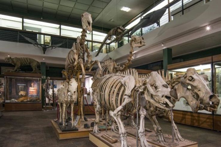
Travel Bucket List: India – Uttar Pradesh Part 3

Fatehpur Sikri

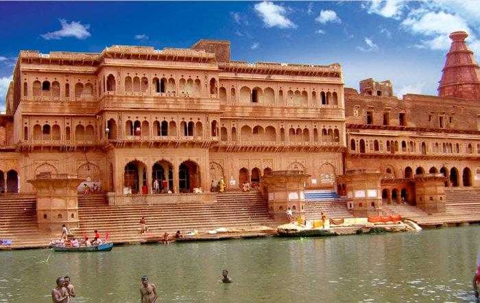
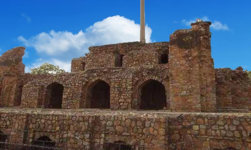
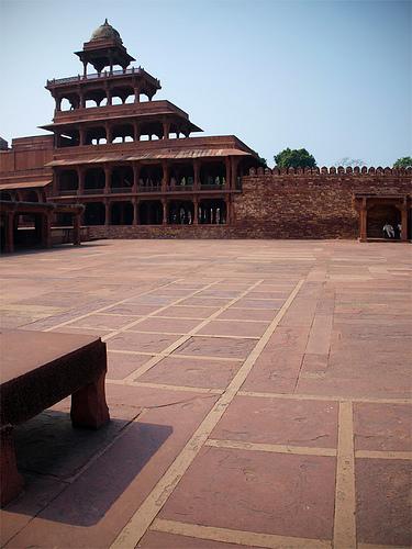
Located close to Agra and about 65 km south of Mathura, Fatehpur Sikri was founded as the capital of the Mughal Empire in 1571 by Emperor Akbar, until 1585 when Akbar abandoned it because of a campaign in Punjab and was later completely abandoned in 1610. The name of the city is derived from the village called Sikri which occupied the spot before. An Archaeological Survey of India (ASI) excavation from 1999 to 2000 indicated that there was a habitation, temples and commercial centres here before Akbar built his capital. The region was settled by Sungas following their expansion and was briefly controlled by the Sikarwar Rajputs in the 12th century. Akbar’s son Jahangir was born at the village of Sikri in 1569 and the same year, Akbar began construction of a religious compound to commemorate the Sheikh who had predicted the birth. After Jahangir’s second birthday, he began the construction of a walled city and imperial palace here. The city came to be known as Fatehpur Sikri, or the City of Victory, after Akbar’s victorious Gujarat campaign in 1573. After occupying Agra in 1803, the English established an administrative centre here and it remained so until 1850 and in 1815, the Marquess of Hastings ordered repair of the monuments at Sikri. Archaeological evidence points to settlement of the region since the Painted Grey Ware period. Today, Fatehpur Sikri is a UNESCO World Heritage Site.

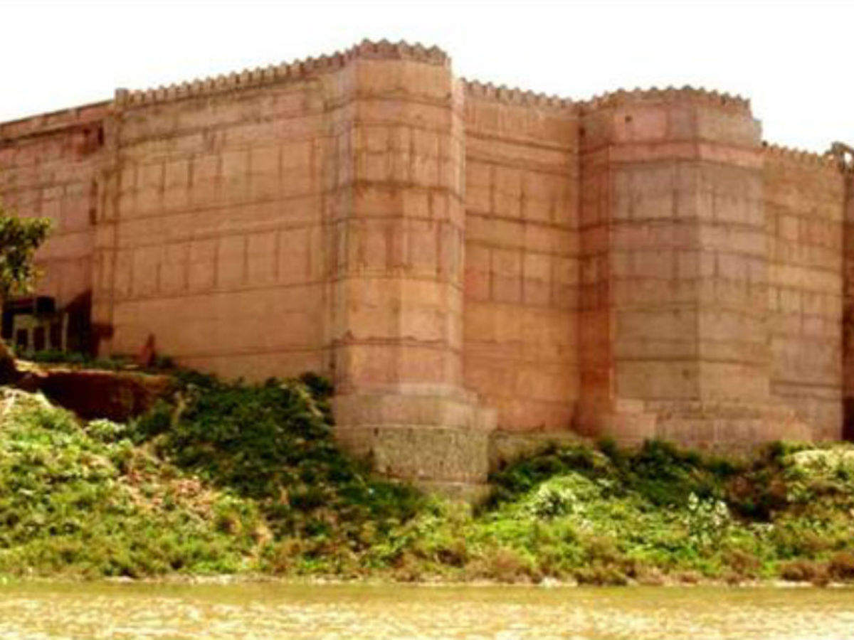
The town sits on rocky ridge, 3 km in length and 1 km wide is surrounded by a 6 km wall on three sides with the fourth bordered by a lake falls roughly into the shape of a rhombus. The dynastic architecture of Fatehpur Sikri was modelled on Timurid forms and styles and was built massively and preferably with red sandstone. Gujarati influences are also seen in its architecture and in the decor of the palaces with the architecture reflecting both Hindu and Muslim form of domestic architecture popular at the time. The town is accessed through gates along the 8 km long fort wall, namely, the Delhi Gate, the Lal Gate, the Agra Gate and Birbal’s Gate, Chandanpal Gate, the Gwalior Gate, the Tehra Gate, the Chor Gate, and the Ajmeri Gate and contains the summer and winter palaces for Queen Jodha.

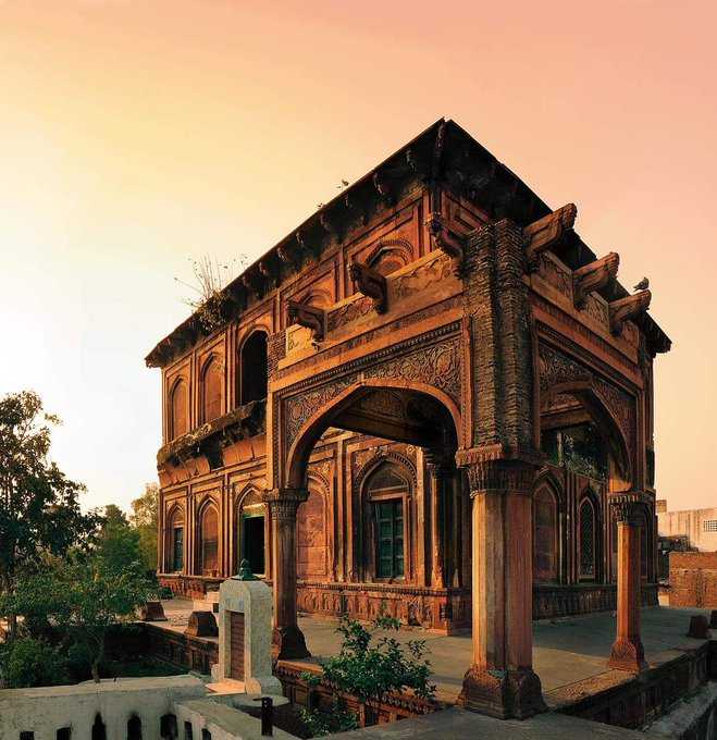
Set into the south wall of the congregational mosque, Buland Darwaza or the Gate of Magnificence is 180 ft high, gradually making a transition to a human scale in the inside. The gate was added around five years after the completion of the mosque, in 1576-1577 as a victory arch to commemorate Emperor Akbar’s successful Gujarat campaign. Made up of red sandstone and decorated with white and black marbles, the gate carries two inscriptions in the archway. The central portico comprises three arched entrances, with the largest one, in the centre, is known locally as the Horseshoe Gate, after the custom of nailing horseshoes to its large wooden doors for luck. Outside the giant steps of the Buland Darwaza to the left is a deep well.

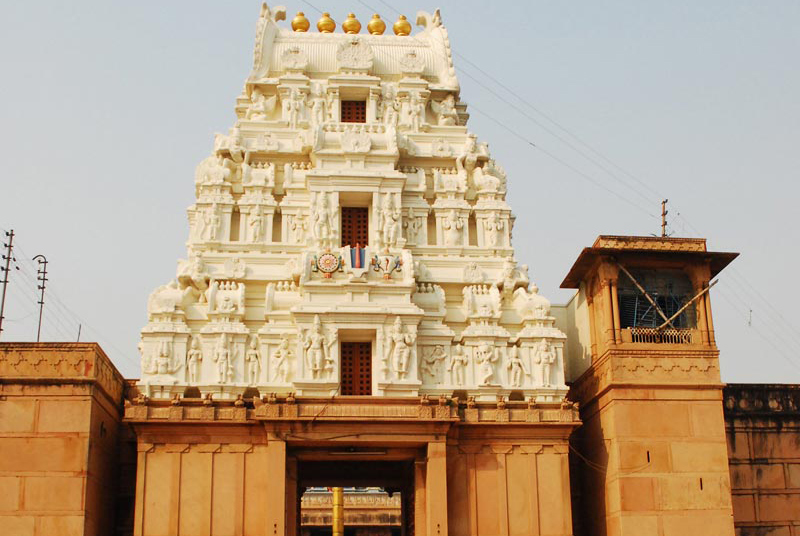
Jama Masjid was It was a congregational mosque and was one of the first buildings erected in the town. Built-in the 17th century, it mosque is a UNESCO World Heritage Site today and is also known as the Friday Mosque. It was built in the manner of Indian mosques, with iwans around a central courtyard. A distinguishing feature is the row of chhatri over the sanctuary. There are three mihrabs in each of the seven bays, while the large central mihrab is covered by a dome, it is decorated with white marble inlay, in geometric patterns. It is constructed in a transition style in a mixture of Islamic architecture and Persian styles. The interiors are embellished with watercolor paintings with corbelled pendentives supporting the dome in comparison to squinches which support the domes usually.

A white marble encased tomb of the Sufi saint, Salim Chisti within the Jama Masjid’s sahn or courtyard. The single-storey structure is built around a central square chamber, within which is the grave of the saint, under an ornate wooden canopy encrusted with mother-of-pearl mosaic. Surrounding it is a covered passageway for circumambulation, with carved Jalis, stone pierced screens all around with intricate geometric design and an entrance to the south. The tomb is influenced by earlier mausolea of the early 15th century Gujarat Sultanate period. Other striking features of the tomb are white marble serpentine brackets, which support sloping eaves around the parapet. On the left of the tomb, to the east, stands a red sandstone tomb of Islam Khan I, son of Shaikh Badruddin Chishti and grandson of Shaikh Salim Chishti, who became a general in the Mughal army during the reign of Jahangir. The tomb is topped by a dome and thirty-six small domed chattris and contains a number of graves, some unnamed, all male descendants of Shaikh Salim Chishti. The tomb is known for blessing childless couples and devotes come from all over the country to pray for children with devotees tying threads over the marble screens as a reminder of their prayers to Salim Chisti.

The Diwan-i-Khas or Hall of Private Audience, is a plain square building with four chhatris on the roof. However it is famous for its central pillar, which has a square base and an octagonal shaft, both carved with bands of geometric and floral designs, further its thirty-six serpentine brackets support a circular platform for Akbar, which is connected to each corner of the building on the first floor, by four stone walkways. It is here that Akbar had representatives of different religions discuss their faiths and gave private audience.

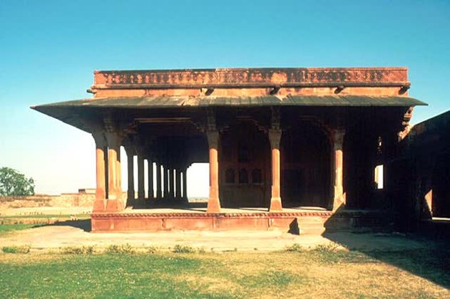
The Diwan-i-Aam or Hall of Public Audience, is a building typology found in many cities where the ruler meets the general public. In this case, it is a pavilion-like multi-bayed rectangular structure fronting a large open space. Standing on 49 pillars, the Diwan-i-Aam consists of a Jharokha type chamber which is also known as Takht-i-Murassa. This place has beautiful decorations all over its pillars and walls. Made of Marble is the Bethak where the ministers were to sit. Two gateways and three aisles divide the hall. South west of the Diwan-i-Am and next to the Turkic Sultana’s House stand Turkic Baths.

Constructed in 1575, the Ibadat Khana or the House of Worship was a meeting house where Akbar had laid the foundations of Din-e-Ilahi. Here spiritual leaders of different religions gathered to conduct discussions of the teachings of their respective faiths.

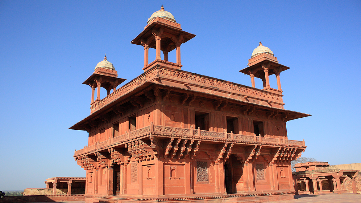
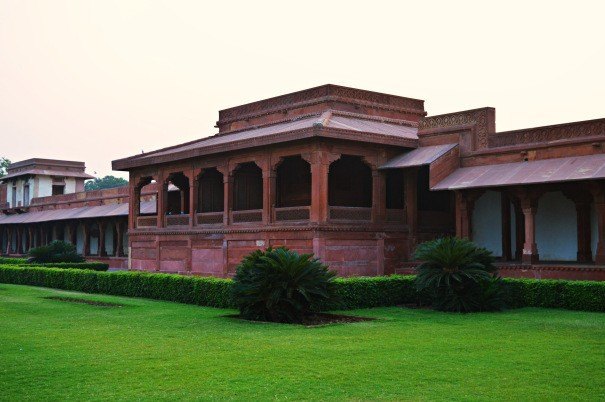
Anup Talao was built by Raja Anup Singh Sikarwar and is an ornamental pool with a central platform and four bridges leading up to it. Some of the important buildings of the royal enclave are surround by it including the Khwabgah or the House of Dreams, Akbar’s residence, Panch Mahal, a five-storey palace, the Diwan-i-Khas or the Hall of Private Audience, Ankh Michauli and the Astrologer’s Seat, in the south-west corner of the Pachisi Court. It is also said to be the residence of Akbar’s muslim wife, although this is disputed due to its small size.

Also known as Harkabai or Jodhabai, Mariam-uz-Zamani was the wife of Emperor Akbar. The building of Akbar’s Rajput wives, including Mariam-uz-Zamani, is built in a fusion of Rajput and Mughal architecture with Gujarati influence and is built around a courtyard, with special care being taken to ensure privacy. It was on the eastern side of the court.

Also known as the Naqqar Khana or drum house, Naubat Khana is where musicians used drums to announce the arrival of the emperor. It is situated ahead of the Hathi Pol Gate or the Elephant Gate, the south entrance to the complex, suggesting that it was the imperial entrance. There are rich carvings on the sandstone walls.

Panch Mahal is a five-storied palatial structure, with the tiers gradually diminishing in size, till the final one, which is a single large-domed chhatri. Originally pierced stone screens faced the facade and probably sub-divided the interior as well, suggesting it was built for the ladies of the court. The floors are supported by intricately carved columns on each level, totalling to 176 columns in all. With design elements of a Buddhist temple, the pavilion gives a splendid view of the fort. Panch Mahal has a pool, the Anoop Talab in front of it which once was a setting for musical concerts.

Akbar’s favorite, Birbal was a Hindu minister in his court. His palace finds its place near the northwest corner of Jodhabai’s Palace. It contains four rooms interconnected with open doorways. Two oblong porches are also there. These have a pyramidical roof with a triangular roof. The interiors are full of single bordered designs, Arabesque geometrical designs, and floral designs. The first floor has beautifully decorated Jharokas and Chajjas. The domes have carvings of inverted lotus and Kalash designs and tile work. The building also has horizontal sloping sunshades or chajjas and the brackets which support them.

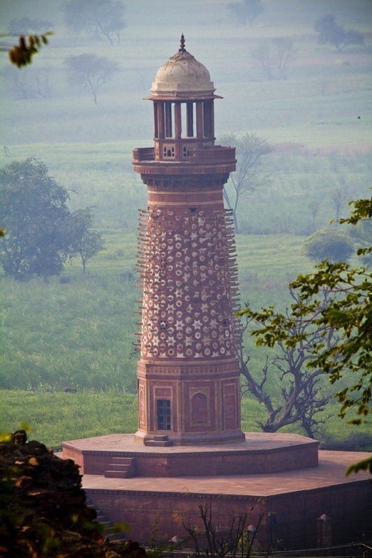
The Hiran Minar, or Elephant Tower, is a circular tower covered with stone projections in the form of elephant tusks. Traditionally it was thought to have been erected as a memorial to the Emperor Akbar’s favourite elephant. However, it was probably a used as a starting point for subsequent mileposts.

A precursor to modern-day offices, the Daftar Khana was Akbar’s record room. It was a place given to the important files and documents associated with his reign. Built on a high platform, the building has facades on all four sides. There is a room inside which has three doorways on its north and beautifully carved tracery work on red sandstones on its south.

Source

The Pachisi or Chaupar Court is a square marked out as a large board game, the precursor to modern day Ludo game where people served as the playing pieces. Built by Kabar in 1572, the emperor and his court played the game of Pachisi, similar to that of modern-day ludo and chess. The game instead of being played with original tokens were played with human beings with servants dressed as tokens of the game and the players instructing the pieces to make the moves.

One of the most beautiful complexes in Fatehpur Sikri, Khwabgah acted as the Emperor’s personal place. It had space for the Emperor to hold meetings, a Kitab Khana or library, a small bathroom, and a bedroom. The bedroom had covered connections with the Panch Mahal and the imperial harem. Where the ground floor is quite simple, the first floor, which was the emperor’s personal space was decorated with geometrical and floral carvings with mural and paintings on the walls depicting court scenes along with Persian inscriptions which are today faded.

Beside Queen Jodha’s palace and opposite Birbal’s palace lies the Lower Haramsara. The reason behind its construction is ambiguous as for some historians it was a stable and for others was a place of servants. The entire structure consists of floral paintings both inside out. The columns here are a mix of Indian and Islamic designs.

Other buildings in Fatehpur Sikri include the Taksal or royal mint, the Karkhana or royal workshops, the Khazana or treasury, the Hammam or Turkish baths, the Darogha’s or security quarters , stables, caravanserai, Hakim’s or doctors quarters.

Agra

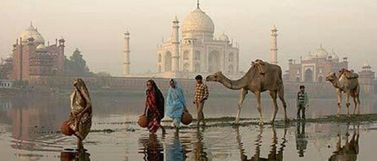
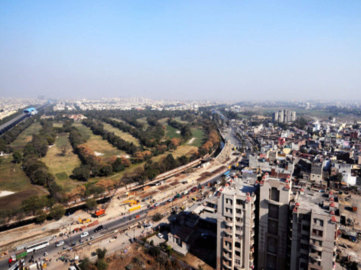
Moving on, lying about 36 km east of Fatehpur Sikri is the city with the monument which speaks of eternal love, the city without visiting for which many, their trip to India is incomplete, Agra, on the banks of the Yamuna and home to the Taj Mahal. With a population of roughly 1.6 million, Agra is the fourth-most populous city in Uttar Pradesh and twenty-third most populous city in India.

During the rule of the Mughals, Agra began it’s golden age and was the foremost city of the Indian subcontinent and the capital of the Mughal Empire under the Mughal emperors Babur, Humayun, Akbar, Jahangir and Shah Jahan. Under Mughal rule, Agra became a centre for learning, arts, commerce, and religion, and saw the construction of the Agra Fort, Sikandra and Agra’s most prized monument, the Taj Mahal, built by Shah Jahan as a mausoleum for his favourite empress.

The name Agra is explained by three different derivations. The most accepted one is that it had its origin from the Hindi word agar meaning salt-pan, a name which was given to it because the soil in the region is brackish and salt used to be made here once by evaporation. Others derive it from Hindu mythology claiming that the Sanskrit word agra which means the first of the many groves and little forests where Krishna frolicked with the gopis of Vrindavan. Another version is that when Sikandar Lodi was sailing down the Yamuna in his royal yacht he asked his steersman to point out a site that was fit for a building a city. Out of the many mounds all around, the steersman pointed to the one directly ahead, supposedly using the Sanskrit word agra or front to express what he meant.

Agra has two histories: one of the ancient city on the east, or left, bank of the river Yamuna, going back so far as to be lost in the legends of Krishna and Mahabharata and reestablished by Sikandar Lodhi in 1504-1505; the other of the modern city, founded by emperor Akbar in 1558, on the right bank of the river which is associated with the Mughals, and known throughout the world as the city of the Taj. Of ancient Agra little now remains except a few traces of the foundations. It was a place of importance under various Hindu dynasties previous to the Muslim invasions of India, but its history is unclear, and possess little historical interest. Akbar built the modern city of Agra on the right bank of Yamuna, where the majority of its part still lies. He converted the city into a great centre of political, cultural and economic importance, connecting it with the various parts of his vast empire. Before his death, Agra had become probably one of the biggest cities in the east, with huge amounts of trade and commerce happening through its bazaars. Shah Jahan later shifted the capital to Shahjahanabad, now known as Delhi in 1648, followed by his son Aurangzeb moving the entire court to Delhi in 1658. With this Agra began rapidly declining, but it continued to be referred to as the second capital of the empire.

In the late 18th century the control of the city fell successively to the Jats, the Marathas, the Mughals, the ruler of Gwalior, and finally the British East India Company. After the decline of the Mughal Empire, the city came under the influence of another post-Mughal Empire power, the Marathas, before falling into the hands of the British East India Company in 1803. Between 1834 and 1836, Agra was the capital of the short-lived Presidency of Agra and then the capital of the North-Western Province from 1836 to 1868 and once of the centres of the Indian rebellion of 1857.

Post India’s independence, Agra has gradually developed into an industrial city, with a significant contribution to the state’s economy. The city is now a popular tourist destination with the Taj Mahal and the Agra Fort UNESCO World Heritage Sites. Today, the Taj Mahal is a symbol of India and Agra has developed into an industrial town, with a booming tourism industry, along with footwear, leather and other manufacturing.

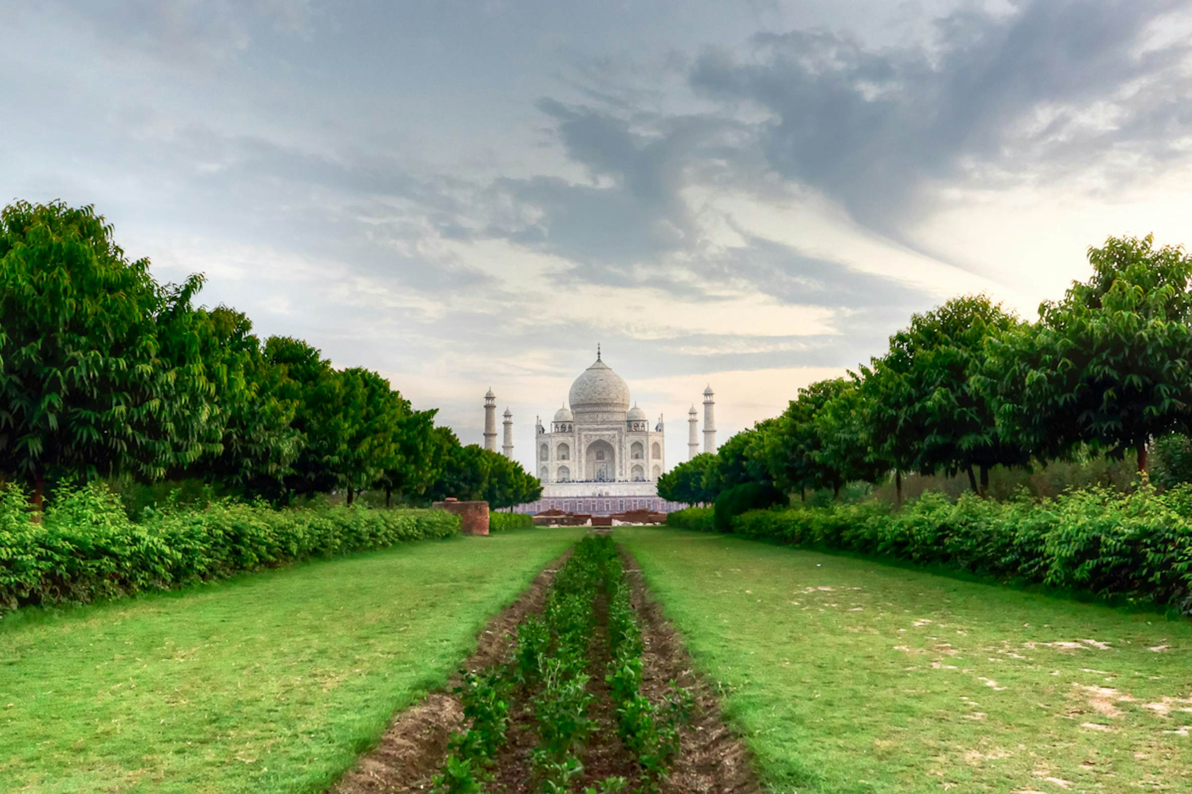
One of the new seven wonders of the world, the Taj Mahal is located on the southern or right bank of the Yamuna river, on the easten part of Agra, about 1.6 km east of Agra Fort. Built by the Mughal Emperor Shah Jahan as a memorial for his third wife, Mumtaz Mahal, it also houses the tomb of Shah Jahan himself. Constructed entirely out of white marble from Makrana in Rajasthan in the 17th century, the Taj Mahal is a UNESCO World Heritage Site.

Covering an area of approximately 42 acres, the construction of the Taj Mahal began in 1631 with upwards of twenty thousand workers from India, Persia, the Ottoman Empire, and Europe and took 22 years before completion. It is distinguished as the finest example of Mughal architecture, a blend of Indian, Persian and Islamic styles. Designed as a unified entity according to the principles of Mughal architecture, the five principal elements of the complex were the main gateway, garden, mosque, jawab literally meaning an answer, a building mirroring the mosque and the mausoleum, with its four minarets.

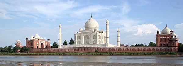
The Taj Mahal can be be observed from Agra Fort from where Emperor Shah Jahan gazed at it for the last eight years of his life, a prisoner of his son Aurangzeb. Verses of the Quran are inscribed on it and at the top of the gate are 22 small domes, signifying the number of years the monument took to build. The Taj Mahal was built on a marble platform that stands above a sandstone one with it’s back to the Yamuna river. Each corner of the platform is graced with 40m high white minarets. The most elegant and largest dome of the Taj Mahal with a diameter of 60 feet and a height of 80 feet is where the tomb of Mumtaz Mahal lies directly below. Shah Jahan’s tomb was erected next to hers by his son Aurangzeb. These tombs are false tombs as the real tombs of Mumtaz Mahal and Shah Jahan lies in a locked room below the main chamber. The four indistinguishable faces of the Taj Mahal are in perfect symmetry, featuring impressive vaulted arches containing pietra dura inlay work, incorporating semi-precious stones and quotations from the Quran. The whole structure is topped off by four small domes.

The Taj Mahal can be accessed through east, west and south gates with tour groups entering through the east and west gates and independent travellers through the south gate. Inside the grounds, the ornamental gardens are set on the classic Mughal charbagh or in the formal Persian garden style. The garden begins at the entryway and spreads across to the base of the mausoleum. Unique to the construction of this garden is the usage of the number four and its multiples as four is considered as the holiest number in Islam. The garden is divided into four parts, with two marble canals studded with the fountains occupying the centre. Each quarter portion of the garden has 16 flowerbeds each of which was planted with 400 plants.

The best time to visit Taj Mahal is during sunrise when it looks the most majestic and the most comfortable time because of fewer crowds. Another magical time to visit the Taj at sunset. One can also visit it for five nights including a full moon night and two nights before and after the full moon. The dates and timings are decided by the Archaeological Survey of India and night viewings take place between 8:30 pm and 12:30 am in eight batches of about 50 people each for 30 minutes each time with only 400 visitors allowed on a single night. The entry tickets for this time is limited though, and it must be bought a day in advance from the Archaeological Survey of India office.

Other attractions in the complex include the twin mosque buildings placed symmetrically on either side of the mausoleum, gardens, and a museum. However, air pollution caused by emissions from foundries and other nearby factories and exhaust from motor vehicles has damaged the Taj Mahal, notably its marble facade. A number of measures have been taken to reduce the threat to the monument, among them the closing of some foundries and the installation of pollution-control equipment at others, the creation of a parkland buffer zone around the complex, and the banning of nearby vehicular traffic, and more recently, use of a mud pack therapy. Most importantly, the 10,400 sq km Taj Trapezium Zone has been created around the Taj Mahal and other nearby monuments where strict pollution restrictions are in place on industries, following a 1996 Supreme Court of India ruling.

The Taj Mahal opens 30 minutes before sunrise and closes 30 minutes after sunset and is closed on Fridays when it is accessible to practising muslims to attend the prayers in the afternoon. Entry fees for Indian is INR 45, for SAARC and BIMSTEC citizens, it is INR 535 and for other foreigners, it is INR 1050 with children below the age of 15 having free entry. For all visitors, including children, there is an additional fee of INR 200 to see the main mausoleum. The ticket price include a 500 ml bottle of water and shoe covers. Visitors can also pick up an audio guide for INR 118 from the ticket counter.

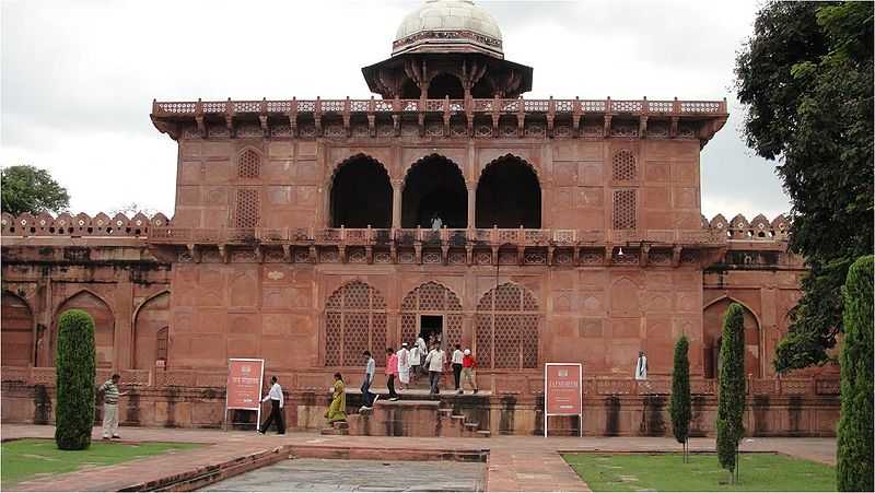
The Agra Fort is a large 16th century fortress of red sandstone first established by the Emperor Akbar and served as the seat of royal government when Agra was the capital of the Mughal empire in addition to being a military base and a royal residence. Built on the site of an earlier fortifications by Islam Shah Suri, the son of Sher Shah Suri. Agra Fort lies on the right bank of the Yamuna river and is connected to the Taj Mahal which lies downstream, around a bend in the Yamuna, by a stretch of parkland. The fort was commissioned by Akbar in 1565, taking around eight years to build. Though much of the structure of the fort was founded by Akbar, both the interior and exterior underwent considerable changes under his son Jahangir and grandson Shah Jahan, who added many new structures, often of marble. The red sandstone walls of the roughly semi-circular structure have a perimeter of about 2.5 km, rise 21 metres high, and are surrounded by a moat. There are two entrances in the walls, the Delhi Gate facing west, the original entrance, situated nearly opposite to the Agra Fort railway station and Jama Masjid, and decorated with intricate marble inlays; and the Amar Singh Gate, also known as Hathi Pol or Elephant Gate facing south, presently the only means in or out of the fort complex. The complex of buildings in the fort is reminiscent of Persian and Timurid architecture with great inspiration from Jain and Hindu architecture and forms a city within a city. Today Agra Fort is the second UNESCO World Heritage Site in Agra, after the Taj Mahal.

Among the major attractions in the fort is Jahangiri Mahal, the largest residence in the complex, built by Akbar as a private palace for his son Jahangir. This was adjacent to Queen Jodha’s palace and is built in stone and simple in its design with Persian verses carved out in a large stone bowl used for storing rose water. In the Diwan-i-Am or the Hall of Public Audience where the emperor would listen to public petitions and meet state officials. The Diwan-i-Khas or the Hall of Private Audience was used for receiving distinguished visitors. The famous Peacock Throne was once kept there, before Aurangzeb took it to Delhi. This hall was intricately decorated with marble pillars studded with floral patterns of semi-precious stones. Adjacent to the Diwan-i-Khas stands the Musamman Burj, an octagonal Tower which was the residence of Shah Jahan’s favourite empress, Mumtaz Maḥal. The Moti Masjid or the Pearl Mosque, constructed by Shah Jahan, is a structure made entirely of white marble. The emperor’s private residence was the Khas Mahal, whose marble walls were once adorned with flowers depicted by precious gems with classical Persian and Islamic influences with a touch of Hindu motifs in its construction. Located to its northeast is the Sheesh Mahal or Palace of Mirrors with its walls and ceilings inlaid with thousands of small mirrors and employs the most sophisticated water engineering designs. Mammam-E-Shahi or the Shah Burj was used as the summer retreat, while the Nagina Masjid was built by emperor Shah Jahan as a private mosque for the ladies of the court while the Mina Masjid was the private shrine of Emperor Shah Jahan. Today some parts of the Agra Fort is used by the Indian Army and is off-limit to public access. The fort also served as a prison for Shah Jahan when Aurangzeb, his son and successor as emperor, had him confined there from 1658 until his death in 1666. The fort is open between sunrise and sunset and entry fees for Indians is INR 40 while foreigners pay INR 550. Children below the age of 15 enter free and entry into the fort is only allowed through the Amar Singh gate.

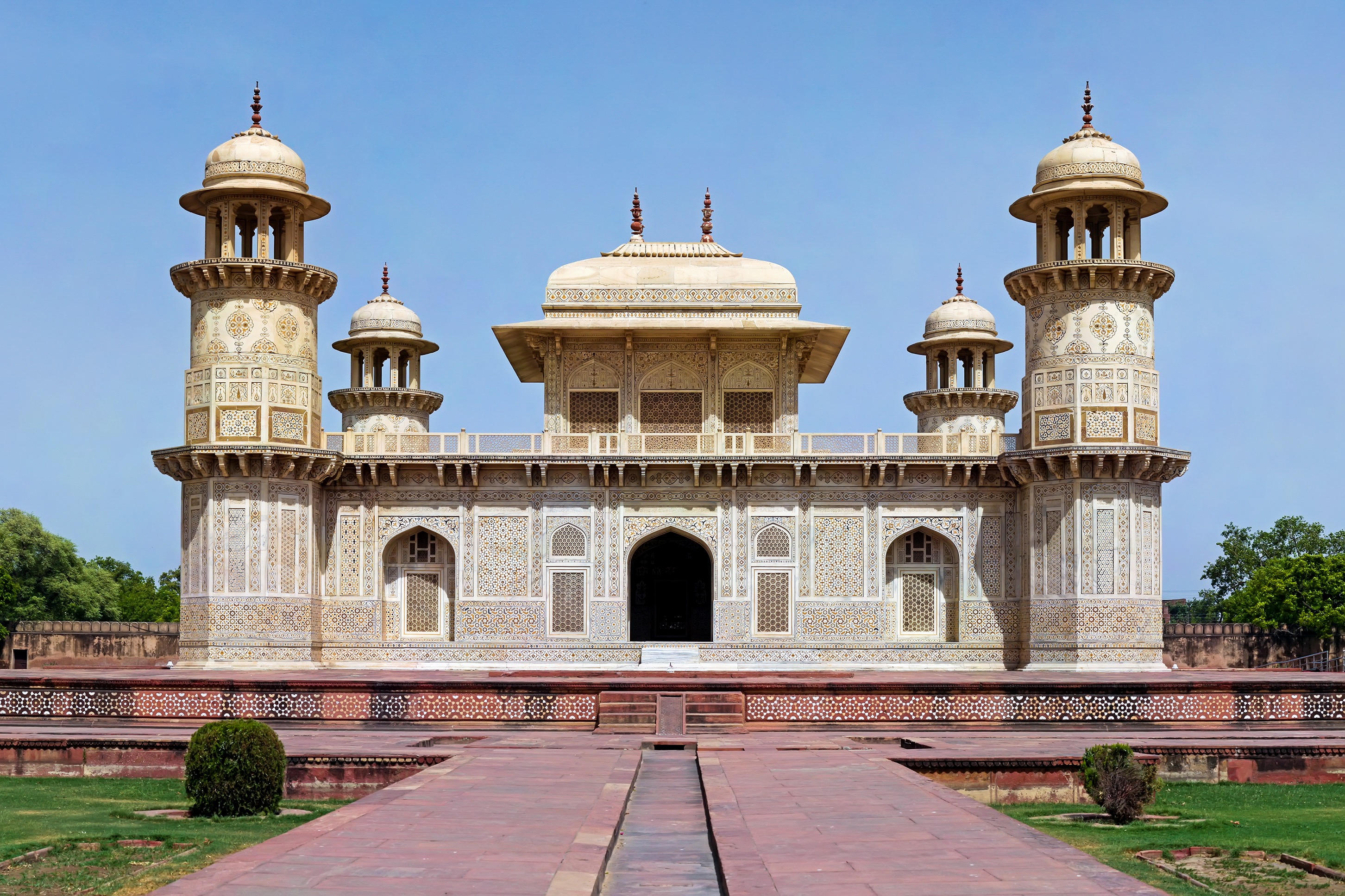
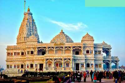
Often referred to as the Baby Taj Mahal, the tomb of Itimad-ud-Daulah is a Mughal mausoleum and is the first tomb in India made entirely of marble. The tomb was commissioned by Nur Jahan, the wife of Jahangir, for her father Mir Gheyas Beg, later known as Itimad-ud-daulah, A minister in the court of Jahangir. The tomb marks the transition from the first phase of the Mughal architecture to the second. This was the first structure to make use of pietra dura and the first to be built on the banks of the Yamuna River and consists of Indo-Islamic architecture, with the use of arched entrances and octagonal shaped towers. A bird’s eye of Itimad-ud-daulah Tomb shows  it looks like a jewel box set in a garden. Located on the left bank of the Yamuna river, the mausoleum is set in a large cruciform garden, criss-crossed by water courses and walkways. On each corner are hexagonal towers, about thirteen metres tall. The walls are white marble from Rajasthan encrusted with semi-precious stone decorations made of cornelian, jasper, lapis lazuli, onyx, and topaz in images of cypress trees and wine bottles, or more elaborate decorations like cut fruit or vases containing bouquets. Light penetrates to the interior through delicate Jali screens of intricately carved white marble. The tomb is made of white marble and placed on a large red sandstone platform, which can be accessed by four monumental gateways. The inner space of the tomb is divided among 9 Chambers, with the central chamber being the largest of all and accessible only from the southern side. There are cypress tree and other floral decorations on the wall, that give off an essence of the Persian architecture. The origin of lattice jali is from Gujarat and has been used extensively during the Mughal reign. The Eastern gate is the main entrance, the Western gate, a waterfront pavilion and the Southern and Northern gates are to just maintain symmetry. These gates are made with red sandstone and have geometric designs and chine khana designs on white marbles. The square-shaped tomb has four turrets which are adorned with small domed kiosks known as Chattris. These Chattris, one on each corner rise from an octagonal base. There are jali works from the arched entrance of the tomb to the centre of the mausoleum. The garden around the tomb is square in shape and divided into 4 quadrants, with the tomb in between. The garden includes walkways and water channels. The garden is also symmetrically maintained and each of its quadrants represents each sea of paradise. The garden also comprises of 4 rectangular pools with fountains, which enhances the beauty of the overall area. The tomb remains open from dawn to dusk and one can visit anytime during the day. However, to catch the monument at its best, it is recommended to visit during sunrise or sunset.

The final resting place of the Mughal Emperor Akbar, is situated in Sikandra on the outskirts of Agra, about 13 km from the Agra Fort and spreads over an area of 119 acres. Built entirely out of sandstone and white marble between 1605 and 1618., the four-storied tomb combines both marble and sandstone in its exterior. The construction of Sikandra was commenced in Akbar’s reign, and was completed by his heir and son Jahangir in 1613. The tomb, built in a mixture of Hindu Rajputana design and gothic Mughal style is set amidst a large garden, and is enclosed by four battlemented walls, each with a large gateway. The shape of the tomb is pyramidal and has four storeys and a marble pavilion, which contains the false tomb with the true tomb in the basement. The 99 names of Allah have been inscribed on the tomb. The tomb has seen some damage to its minarets and other aspects, which was inflicted by the Jats of Bharatpur. The vast gardens around Sikandra are inhabited by several Blackbucks, which are in the process of being shifted to the Etawah Safari Park. The ground floor is surrounded by walkways all around except at the centre of the southern side, which is the way that leads in from the main gate. These arcades are divided by huge arches and piers that divided the walkways into many bays. The next three storeys are square with arcades and clusters of kiosks on each side. In the second storey, some of the kiosks have marble roofs in pyramidal shapes. The rest of the kiosks are crowned by cupolas. Every end of the third storey has a small square shaped room. The top storey that is, the pavilion is made entirely of white marble. It has an open-to-the-sky square court. Slender arches and piers have enclosed the central courtyard, dividing it into many bays. A square platform lies at the centre of the courtyard over which the false tomb is laid out, made of marble. The tomb had floral patterns and arabesque beautifully carved on to it. Unlike other muslim kings, Akbar’s Tomb faces towards the rising sun instead of Mecca. The tomb is open from sunrise to sunset every day except Fridays when it is closed. Entrance fees includes a development authority fee of INR 5 for Indians, with citizens of SAARC and BIMSTEC countries paying INR 25 as well as a toll tax from the Agra Development Authority of INR 10. Other foreigners pay INT 110 and children under the age of 15 enter free. Foreigners who purchase the Agra Development Authority toll ticket of INR 500 for Taj Mahal, do not need to purchase any other toll ticket if they visit Akbar’s Tomb on the same day.

Chini ka Rauza is the tomb of Allama Afzal Khan Mullah, the Prime Minister of the Mughal Emperor Shah Jahan. Also known as China Tomb, it was built between 1628 and 1639 and has a marvellous fusion of the Indo-Persian style. It is the first monument of its kind to be decorated by glazed tile work, known as chini. The tomb is located 1 km north of Itimad-ud-Daulah’s tomb, on the banks of the river Yamuna and is is built facing Mecca. The tiles for the mausoleum are known to have been imported from China. The rectangular building has striking features, the most alluring of which are the turquoise, orange, yellow and green coloured tiles also known as kashi or chini. It’s dome has been elevated to give a two-storeyed effect to the building. The chief chamber is octagonal in shape, has eight arched clefts and is connected to the four side halls. Built-in the Afghan style of architecture, Chini ka Rauza is believed to be the only building in India with Persian architectural designs. The interiors of the shrine are adorned with intricate paintings and inscriptions from the Quran.

One of the last Mughal gardens in Agra, Mehtab Bagh is a charbagh or four garden complex located just north to the Taj Mahal and overlooking the Agra Fort on one side and the Yamuna river on the other. Perfectly aligned with the gardens of Taj Mahal, Mehtab Bagh provides a picture-perfect view of the Taj from the fountain at the front of the entrance gate and is a popular sunset photography spot. The garden has four sandstone towers, one each at the corner with a huge octagonal tank right in the centre. It is believed that Shah Jahan got the bagh designed so he could admire the beauty of Taj Mahal. On the moonlit nights, the clear reflection of the wondrous Taj Mahal in the waters of the park is a sight worth seeing. The Bagh has scores of vibrantly blooming floral plants and medicinal herbs, besides fruit trees. Originally built in 1530 by the Mughal Emperor Babur, the garden fell into disrepair until Shah Jahan renovated it into a moonlit pleasure garden in the Persian style layout with plastered pavilions elevated walkways, ornamental fountains and pretty pools. In 1994, excavations carried out by the Archaeological Survey of India (ASI unearthed an octagonal tank, 25 water fountains and a four-complex divided compartment. The garden compound is constructed with red sandstone, brick and lime plaster. There is a stepped waterfall present in the north that feeds the octagonal pond on the southern end. this pond. Of the four towers, only one tower stands today, towards the south-east side and a large water tank on the east, with many water channels. The garden also houses two ruined structures which are presumed to be the garden pavilions that did not survive the passage of time and an aqueduct in the north that waters the garden. Mehtab Bagh is open between 6 am to 6 pm and Indians and SAARC nation visitors pay INR 30 as entrance fees while other foreigners pay INR 200.

Built by emperor Shah Jahan in 1637 as his personal leisure garden, Anguri Bagh is a sprawling charbagh or four compartment styled garden complex, on the premises of the Khas Mahal in Agra Fort. Originally popular for the thick creepers of grapes, the garden came to be called as Anguri Bagh or the Garden of Grapes. The structure in the garden is made of fine white marble which was painted and gilded in gold and adorned with beautiful paintings. The main part of this structure consisted of a hall with a recess and rooms in a surrounding semicircular pattern and a huge courtyard in the front with tanks, fountains and hammams overlooking the garden. Anguri Bagh is open between sunrise and sunset and the entry fee for Indians is INR 40 while foreigners need to pay INR 510.

The Aram Bagh, commonly known as Ram Bagh today, is one of the oldest Mughal garden in India, and was built by the Mughal emperor Babur in 1528 on the bank of the Yamuna. It lies about 2.3 km (1 mi) north of the Taj Mahal. The original name of the gardens was Aram Bagh, or ‘Garden of Relaxation’, and this was where Babur used to spend his leisure time.

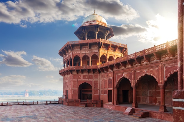
Also known as the Friday Mosque, the Jama Masjid is a seventeenth-century structure and one of the largest mosques built by the Mughals in India. Constructed under the reign of Shah Jahan in 1648, the Jama Masjid is dedicated to his favourite daughter Jahan Ara Begum. This splendid monument is visible from the Agra Fort with the Agra Fort Railway station right between the two structures. Built mainly of red sandstone and white marble , the mosque has a fountain at the centre and is supported by four kiosks in the courtyard. The interior walls have scriptures in the Persian style praising Shah Jahan and Jahan Ara and the inlaid panels are similar to that of Taj Mahal. Every Friday, special prayers are conducted and the Tomb of Salim Chisti is a part of the mosque compound. The Jama Masjid has many domes, out of which the prayer dome is the largest. The Buland Darwaza is forty meters high and is built of red sandstone and is semi-octagonal in pattern and contains three massive domes at the top. These domes are followed by three smaller domes and twelve tiny domes at lower levels. The impressive arches at the courtyard are supported by pillars covered in red sandstone. The domes are decorated by an inverted lotus and are ornamented by a Kalash at the top. The designs on top of these domes are made of alternating stripes of marble and red sandstone. Entry to the Jama Mosque is possible through five entrances with the gateway embellished with small layers of sandstone. The Iwan or the rectangular hall walled on three sides has a central arch with several geometric patterns. Jama Masjid is open from 7 am to 12 noon and then from 1:30 to 6:30 pm. While entry is free, photography charges are INR 30. Feet are expected to be covered and women are expected to cover their heads while inside the mosque.

Located inside the Taj Mahal complex, the Taj Museum was established in 1982 on the western end of the Taj Gardens. The tiny but terrific depository is a double-storeyed building with a quadrangle projection outside. Situated a little left on the main gate of the mausoleum inside the Jal Mahal, the museum provides the wonderful opportunity to have a close look at the blueprints, art and artefacts used in the construction of the monument. Spread over two floors, the museum boasts of three galleries in addition to the main hall. The main attraction is the 17th-century ivory portraits of the Mughal emperor Shah Jahan and his beloved queen Mumtaz Mahal. Other than that, there are a dozen paintings, frescoes and sketches of the planning and designing of the Taj Mahal, in addition to umpteen antiques, miniature paintings, manuscripts, government decrees, arms, utensils, specimens of inlay works etc. The first gallery is a depiction of the brainstorming involved behind the construction of Taj, site plans, and various letters sent to and fro between Shah Jahan and Raja Jai Singh of Jaipur ensuring the smooth supply of makrana marble. The second gallery showcases some jade and porcelain objects including a jade Quran stand, beautifully ornamented vase of the same material, nifty celadon ware utensils, arms and specimens of other semi-precious stones etc. The third gallery is a display of documents, farmans, famous calligraphy works and the paintings of the monument post completion. The museum also houses many original Mughal miniature paintings. As well as some Caledon plates which are said to split into pieces or change colour if the food served on them contains poison. The museum is open between 10 am and 7 pm and is closed on Fridays. Entrance charges are INR 20 for Indians and INR 750 for foreigners.

Established in 1995, Wildlife SOS is a non-profit organisation that rescues and rehabilitates wild animals and forests. Its Agra Bear Rescue Facility is the largest sloth bear rescue facility in the world housing 130 sloth bears. The Elephant Care and Conservation Centre, located halfway between Agra and Mathura, rescues and rehabilitates abused and captive elephants. To visit any of the conservation facility of Wildlife SOS, one must email or phone in advance to book a time slot. There are 3-4 slots available per day with the package facilitating a guided tour of the area and the presentation of a well-informed documentary showcasing the rescue of dancing bears and their recovery. Wildlife SOS is open between 9 am and 1 pm and then between 2 to 6 pm with the entry fee for one being INR 6500, for two INR 5600,  for three people INR 5500 and for 4 or more people it is INR 5300 per person.

The Keetham Lake Bird Sanctuary also known as the Sur Sarovar Bird Sanctuary is situated within the Surdas Reserved Forest and has nearly two dozen varieties of migratory and resident birds.

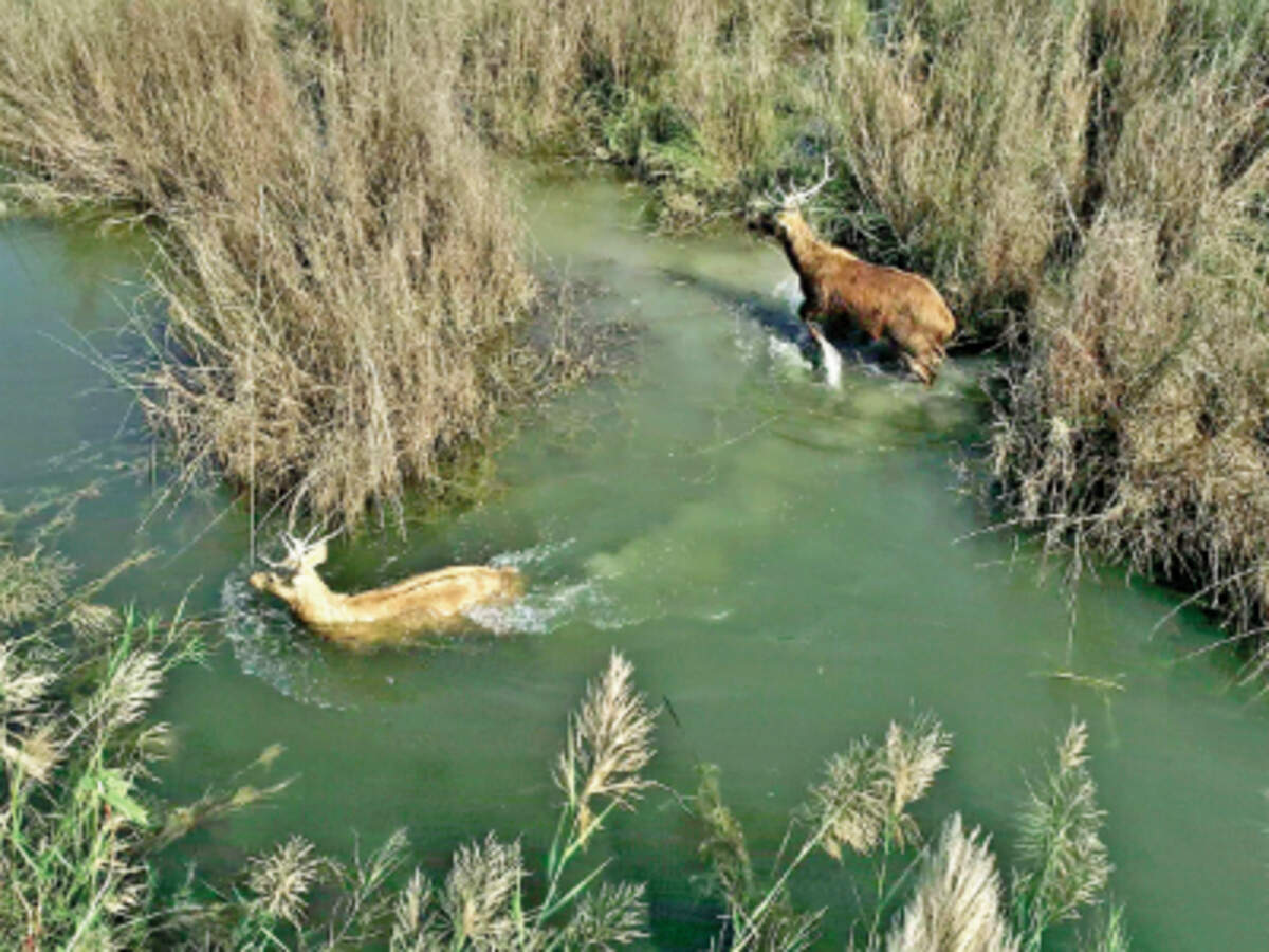
103 km south of Agra lies the National Chambal Wildlife Sanctuary, home to the Gharial, red crowned turtles, Gangetic Dolphins and Indian skimmers, among others. Surrounded by the Chambal river, the cleanest river in the country, the sanctuary provides visitors with an unpolluted habitat, abundant wildlife, amazing landscapes, medieval temples and magnificent ancient ruins. Tourists usually rent a motorised boat to go up and down the river as it flows through the ravines which provides visitors an up close and personal view of the birds and animals. Walks around the river and ravines are also organised and alongside the normal jeep safari, this national park offers visitors with a river safari, bicycle rides, camel safaris and horse safaris. The Chambal River Safari is the highlight of the sanctuary, almost 3 hours long and the best way to enjoy the view of the sanctuary. The Chambal river is the lifeline of the forest and meanders its way across the states of Madhya Pradesh, Rajasthan and Uttar Pradesh. Boats with a seating capacity of few more than a dozen people are arranged by the Chambal Safari Lodge which carry visitors through the river and also have guides. The endangered Gharial and the Ganges River Dolphin are the major attractions of the sanctuary with other inhabitants including Muggar crocodiles, Bengal Foxes, Indian Grey Mongoose, Smooth-coated Otters, Striped Hyaena and the Indian Wolf. Chambal is also home to 8 out of 26 rare turtle species found in India and a haven for many migratory birds.

Garhmukteshwar

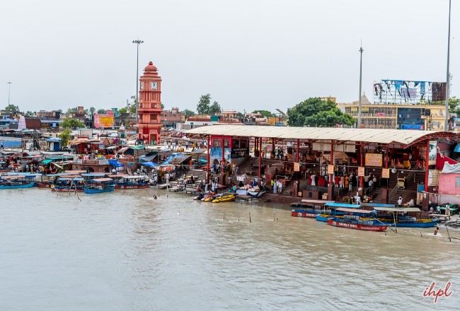
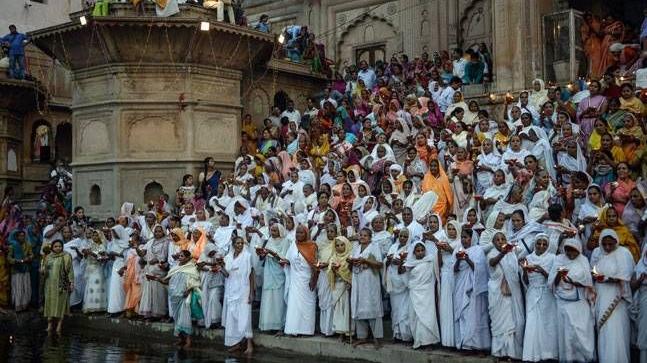
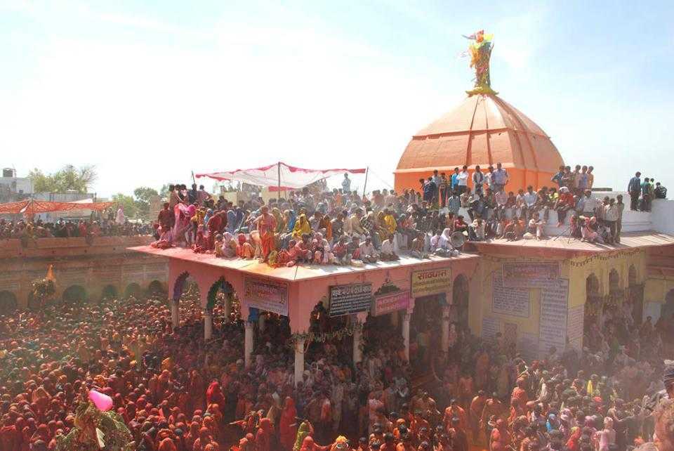
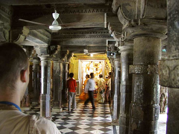
Moving on from Agra, we now travel 265 km north to Garmukteshwar, a popular pilgrim spot situated on the banks of the River Ganges. A popular day trip from Delhi, it is the closest where one can take a dip in the Ganges during the Ganga Mela held here on the full moon nights in the month of Kartika during October and November when devotees bathe in the waters of the Ganges to cleanse themselves of sins. The Ganges river in Garhmukteshwar is also known for its sightings of the Ganges River Dolphins. Garhmukteshwar is an ancient place that is mentioned in the Bhagavata Purana and the Mahabharata. There are claims that it was a part of ancient Hastinapur, the capital of the Pandavas. An ancient fort, repaired by the Maratha leader Mir Bhawan, became, under the British, the headquarters of the tehsil. The name of the town is derived from the temple of Mukteshwar Mahadeva, dedicated to the Goddess Ganga who is worshipped there in four temples. The town has 80 sati pillars, marking the spots where Hindu widows are said to have become Sati-Mata. The town also has a mosque, built by Gays-ud-din Balban, that bears an inscription in Arabic dating to 682 Hijri or 1283 AD.

In the next part, we will explore some ancient and historic towns in Uttar Pradesh.

Travel Bucket List: India – Uttar Pradesh Part 2

Hastinapur

Located on the banks of an old ravine of the Ganges, Hastinapur lies less than 60 km southeast of Muzzafarnagar. An ancient city, Hastinapur is described in the Mahabharata and the Puranas as the capital of the Kuru Kingdom and is located on the right bank of the Ganga river. Translates to the City of Elephants in Sanskrit, Hastinapur’s history dates back to the period of the Mahabharata with several evidences noting that the city was named after King Hasti. The city also been known by other names, such as Gajapuram, Nagapura, Asandivata, Brahmasthalam, Shanti Nagaram and Kunjarpuram, in different ancient texts. Excavations carried out in Hastinapur in the early 1950s unearthed matrials which correlated between the text of the Mahabharata and the material remains uncovered. Hastinapur is also the birth place of three Jain Teerthankara, and it has become an important centre of pilgrimage for the Jains.

According to a popular belief, Ashtapad exists in the high mountain range of Himalayas, some 250 miles north of Badrinath and was believed that it was here that the first Jain Tirthankara, Bhagwan Rishabhdev attained his salvation. It is believed that who visits Ashtapad attains salvation and with this belief in mind, the Jains made a copy of Ashtapad in Hastinapur. Ashtapad which means eight steps, is 151ft tall with a diameter of 10 8m with the height of every step equal to the diameter.

A huge complex comprising of various Jain temples designed in different designs, the Jambudweep Jain Tirth is an important pilgrimage site for those of the Jain faith. There are various temples, some of them quite big, and a meditation hall within the campus. The Sumeru Parvat, Teen Lok Temple, Lotus Temple are some of the fascinating temples inside.

The Bada Digambar Mandir is one of the oldest Jain temples and is situated on a 40 ft high hillock with a magnificent structure which sees a huge number of devotees to worship the statue of Bhagwan Shantinath in a Padmasan. It is believed that the prayer offered here are always received well. There are multiple temples in this complex including the Kailash Parvat Temple, the Nandeeshwara Dweep, the Trimurti Mandir and the Maan Stambha as well as 24 tonks, a Petrograph and various Shrines.

The Kailash Parvat Rachna is a 40-metre-high structure, home to several Jain temples, including the Yatri Niwas and Bhojanshala. There is also an auditorium and a helipad on the premises.

The Pandeshwar temple is dedicated to Lord Shiva and is believed to be the place where Kauravas and Pandavas received their education in the Vedas and the Puranas. A temple of the Goddess Kali and many ashramas are also present on a hillock between the ruins. Legend has it that in the Mahabharata period, Pandu’s eldest son Yudhishthira, had established the shivalinga at the Pandeshwar Mahadev temple before the war of Mahabharata and prayed to Shiva for a blessing of winning the war.

The Karna Temple is located near the Pandeshwar temple on an old ravine along the bank of the Ganges with the shivling inside the temple believed to be established by Karna, one of the prominent figures in the Mahabharata.

The Bhai Dharam Singh Gurudwara is located in the Saifpur village about 2.5 km from Hastinapur and is considered to be one of the holiest pilgrimage centers for the Sikh community. Established by Bhai Dharam Singh, one of the panj pyaare, instructed by Guru Gobind Singh at Anantpur Sahib for forming the nucleus of Khalsa.

Also called as the Hastinapur National Park, the sanctuary spread across 2073 sq km was established in 1986 and is home to a wide variety of flora and fauna. Known to conserve a huge number of bird species and home to a variety of mammals, reptiles, amphibians, invertebrates, herbs and shrubs, peacocks can be spotted here in large numbers.

Vrindavan

Known as Lord Krishna’s childhood abode, Vrindavan is one of the oldest cities on the banks of Yamuna. The name of the town has been derived from Vrinda, meaning basil and van which means a grove, probably referring to the two small groves at Nidhivan and Seva Kunj. About 250 km south of our last destination, Hastinapur, the town hosts hundreds of temples dedicated to Lord Krishna and Goddess Radha scattered throughout, the most famous ones being the Banke Bihari temple and the ISKCON temple. One of the most sacred places in Vaishnavism, Vrindavan is located in the Braj Bhoomi region, and is where, according to Hinduism, Lord Krishna spent most of his childhood days and is about 15 km north from Mathura, Krishna’s birthplace.

Vrindavan was established in the 16th and 17th centuries as a result of an explicit treaty between the Muslims and Hindu Emperors. But the essence of Vrindavan was lost over time until the 16th century, when it was rediscovered by Chaitanya Mahaprabhu who visited in 1515 to locate the lost holy places associated with Lord Krishna’s life.

Vrindavan is also known as the city of widows due to the large number of widows who move into the town and its surrounding area after losing their husbands. There are an estimated 15,000 to 20,000 widows who come from the states of west Bengal, Assam and Odisha.

The Shri Banke Bihari Mandir is dedicated to Lord Krishna. Built in 1862, the temple is in the Rajasthani style of architecture and is adorned with arched windows and stonework. The image of Lord Krishna in the temple appears in the form of a child and is seen standing in the Tribhanga position. There are no bells or conchs in the premises, as it is believed that the Lord does not like the sound of these instruments with invocations performed by peaceful chants of Radha Naam.

The word Banke means bent in three places, while the word Bihari means supreme enjoyer.  The idol in Banke Bihari Temple was originally worshipped under the name of Kunj Bihari which means the enjoyer of lakes. The lord is worshipped in three parts every day including Shringar, Rajbhog and Shayan. While Shringar, which includes bath, dressing and adornment with jewellery like crown and necklaces and Rajbhog or feast are offered in the forenoon, the Shayan Sewa which is the sleep worship is offered in the evening. In summers, the temple opens at 7 am with the morning aarti between 7:45 to 8 am and darshan from 8 am to 12 noon and then again between 5:30 to 9:30 pm. During the winter months, the darshan timings are between 8:45 am to 1 pm and then between 4:30 to 8:30 pm. The Mangala aarti is held in the temple during Janmashtami, while Akshaya Tritiya is the only day when one can see the deity’s lotus feet. The deity can be seen wearing a special crown and carrying a flute only on the full moon day in autumn. During the last five days of the Hindu month of Phalguna, the festival of Holi, the Deity comes off his altar and can be seen fully. It is also around this time that he can be seen with four gopis. The Jhulan Yatra or the swing festival of Lord Krishna is celebrated on the third day of the waxing moon, where Lord Banke Bihari is seated on a golden swing known as a hindola. The curtain is pulled shut and then opened again, every few minutes, unlike other temples. It is believed that the eyes of Banke Bihari are so brilliant at this time that it can make anyone unconscious if seen for a long time.

Source

Prem Mandir is a massive temple built by Jagadguru Shri Kripaluji Maharaj in 2001. Known as the Temple of God’s Love, it’s dedicated to Radha Krishna as well as Sita Ram and made of white marble and adorned with intricate carvings. Various scenes from Lord Krishna’s life have been depicted on the periphery of the temple. Built in the Rajasthani Somnath Gujarati architectural style, the temple is situated on a 54-acre site on the outskirts of Vrindavan and constructed using Italian marble. The structure is 125 feet tall, 122 feet long and 115 feet wide. Doors and windows of the temple are beautifully carved, with the walls and floor adorned with colourful semi-precious stones depicting floral vines blooming with buds and flowers. The pillars are intricately engraved with beautiful statues depicting the Kinkari and Manjari Sakhis serving Shri Radha Krishna in a variety of ways. The temple also houses a circumambulation route, consisting of 48 panels and 84 panels on the exterior depicting the Shri Radha Krishna. The first floor of the temple has spectacular idols of Lord Krishna and Goddess Radha, while the second floor is dedicated to Lord Rama and Goddess Sita. A striking feature of the temple is the musical fountain show which takes place every evening from 7 to 7:30 pm. The temple is open daily between 5:30 am and 8:30 pm.

The Sri Radha Raman Mandir, dedicated to Lord Krishna in the Radha Raman or the giver of pleasure to Radha avatar is known to house a saligram or a self-manifested deity of Lord Krishna with a mystical smile on his face as Radha Ramana, alongside Goddess Radha. The temple is said to be one of the most significant among the seven temples of Thakur of Vrindavan and holds importance especially among the followers of Gaudiya Vaishnavism. The temple was established in 1542 and renovated in 1826. An interesting fact about this temple is that even though it is dedicated to and named after Goddess Radha, there is no deity of Radha Rani in the temple, instead a crown is kept next to Lord Krishna to signify her presence. The temple is built in the modern Hindu architectural style and the temple is open between 8 am and 12:30 pm and then again from 6 to 8 pm daily. The mangala aarti takes place at 4 am during winters and 5:30 am during the summer.

Also known as Sri Sri Krishna Balaram Mandir, the ISKCON Vrindavan is the fulfilment of the dream of Swami Prabhupada, the founder of the ISKCON movement, who wished to build a temple for the brothers, Lord Krishna and Lord Balaram where they played together several centuries ago. The three altars here are the seats of Sri Sri Gaura Nitai, Shri Krishna and Balaram and Sri Sri Radha Shyamasundara along with Lalita and Vishakha. The presiding deity of the temple, however, is Lord Krishna-Balaram with two idols on the central slab of the temple depicting Lords Krishna and Balarama. On the right dais are the idols of their friends and on the left side is a statue of Chaitanya Mahaprabhu with Nityananda, and of Bhaktivedanta Swami Prabhupada and his spiritual coach Bhaktisiddhanta Sarasvati Thakura. The Vrindavan Chandrodaya Mandir is housed in a modern geodesic structure with a traditional gopuram based on the Khajuraho style of architecture and will be the tallest temple in world on completion. The temple is constructed out of white marble and the galleries of the temple display various pictures of Lord Krishna with the courtyard having beautiful verandah surrounding it with wall paintings of Sri Radha-Krishna and Sri Gaur-Nitai. The first floor of the temple is more like a balcony with 108 flowers painted on the floor. There is guesthouse named ISKCON Guest House inside the temple campus for accommodation. The temple is open during the summer months from 4:30 am to 12:45 pm and then from 4:30 to 8 pm and from 4:30 am to 1 pm and between 4 to 8:15 pm during the winter months.

Source

The Sri Govind Devji temple is an ancient temple built of red sandstone and dedicated to Lord Krishna. Although the original idol no longer exists in the temple, it is said that the idol of Lord Krishna in Govind Devji Temple resembled the face of the lord when he was born. The temple is one of the four temples of particular interest among the thousand within the periphery of the town and is believed to be established by King Vajranabh, the great-grandson of Sri Krishna about 5000 years back. The recorded history of the temple, however, dates back to the 16th century when Sri Rupa Goswami, a disciple of Sri Chaitanya Mahaprabhu went to Vrindavan to find the deity which was lost, at his master’s wishes. Raja Man Singh of Amer and a trusted general of the Mughal emperor, Akbar, began construction of the temple in 1590 on the occasion of Akbar’s pilgrimage to Vrindavan, but the seven-storied temple was destroyed on the orders of Akbar’s grandson, Aurangzeb in 1670, but the demolition was abandoned at three stories. Made of red standstone resembling a European cathedral, the seven-storied temple is considered as one of the most exquisite temples of North India and has an altar inside which is a blend of marble, silver and gold with a sculptured lotus flower decorating the central hall ceiling and is an amalgamation of Islamic and Hindu architecture constructed in the Dravidian style. The idol in the temple was transferred to Jaipur by Raja Jai Singh II before Aurangzeb could destroy it and so the present temple is a tourist site without any rituals being held. A replica of the Lord was installed later in a new temple beside the original structure along with the deity of Sri Radha. The temple is open daily between 4:30 am and 9 pm.

Also known as the Rangji Temple, the Sri Ranganatha Temple is dedicated to Lord Sri Goda Ranagamannar, a South Indian Vaishnava saint, and Lord Ranganatha, an incarnation of Lord Krishna. The highlight of the temple is the idol of Krishna present in the form of the groom with Goddess Goda or Goddess Andal as his bride. Andal was a famous 8th century Vaishnava saint known for composing the Tiruppuvai, a hymn for her beloved Lord Krishna and his birthplace Vrindavan. It is believed that seeing her dedication to him, Lord Krishna answered her prayers by agreeing to become her groom. This is one of the largest temples in North India and one of the 108 Divyadesams for the Vaishnavas. The temple’s east gate is the main gate but entry to the temple is allowed from both gates and a milk abhishek is done every Friday. The idol of Goddess Andal is taken out of the  main sanctorum to the pond every Friday evening. The temple is open from 5:30 to 11 am and from 4 to 9 pm during summer and from 5:30 to 12 noon and between 3 to 9 pm during winter.

The Katyayani Peeth is also known as Uma Shakti Peeth and is one of the 51 Shakti Peethas. The idol of Sati is worshipped here in the form of Uma and is believed that when Lord Vishnu used his Sudarshan Chakra to cut Maa Sati’s body to relieve Lord Shiva from the sorrow of losing his wife, the ringlets of her hair fell in this place. Katyayani Peetha has five different forms of worship,  Goddess Uma or Shakti, Lord Shiva or Shiva, Lord Lakshmi Narayan or Vaishnava, Lord Surya or Saurya and Lord Ganesha or Ganpataya. Jagatdhatri Devi is also worshipped here.The temple is open for worship between 7 and 11 am and again between 5:30 and 8 pm.

Situated between Keshi Ghat and the Radha Raman Temple, the Radha Gokulananda Temple contains idols of Radha Vinoda, Radha Gokulananda and Lord Chaitanya. Although the temple has no elaborate structure, it still holds great significance. The temple also houses a Govardhana-shila that was given by Lord Chaitanya to Raghunath Dasa Gosvami which bears the thumbprint of Lord Caitanya. Originally, there was no deity of Radharani in this temple, but Jahnava Devi had a deity of Radha made in Jagannatha Puri and installed it next to Radha-Vinoda. Built in the Hindu architectural style, the original deity of Radha-Vinoda is worshipped in Jaipur as it was moved to the city to protect it from Muslim invaders, with the temple now having the Pratibha-murtis of the original deities. The temple also has various samadhis placed in a small courtyard of sadhus who resided there. The temple is open from 8 am to 12 noon and from 5 to 8 pm. The mangala aarti takes place at 5 am in the summer and at 6 am during winters.

The Gopeshwar Mahadev Temple is one of the oldest temples in Vrindavan, located close to the Yamuna River and revered for the Shiva Linga established here by the great-grandson of Lord Krishna, King Vrajanabha. The temple holds the confluence of the masculine and feminine powers of nature with the Shiva Linga, the symbol of male power worshipped during the day from 6 to 10 am and and Shiv Linga dressed as a gopi with special shringar ceremonies which is worshipped at night from 5 to 9 pm at the time of the raasleela or the divine dance. The legends of Vrindavan consider Lord Shiva as the first Vaishnav ever and the guru of all Vaishnav since he was a devotee of Lord Vishnu of whom Lord Krishna was an avatar. According to legend, on the full moon night of Sharad Purnima, Lord Krishna along with Goddess Radha was performing the Raas Leela on the moonlit banks of Yamuna River near Vamshivat when Lord Shiva along with his wife, Pravati arrived there to take part in the same. Goddess Parvati was allowed to enter there but Lord Shiva was restricted from it because males were not supposed to take part in it. So, he was stopped on the outskirts of Vrindavan by Vrinda Devi, the deity of Vrindavan who told him that the reason for restricting him to enter is the lack of Sakhibhav which was a must for Raas leela which is intended to please Goddess Radha. Shiva was determined to participate in it and so he meditated with Radha in his mind. Pleased by his meditation, Radha sent her close friend Lalita to bring him over into the Rasamandal after introducing him to Sakhibhav. Lalita went over to Lord Shiva and explained the deepest secrets of Sakhibhav, post which she asked him to take a dip in the holy Yamuna with full passion to achieve Sakhibhav. When Shiva took the dip, he came back as a beautiful damsel and then Lalita took him to Rasamandal. Lord Krishna recognised Lord Shiva and named the female form of him as Gopeshwar. Shiva considered Lalita as his guru since she helped him understand the secrets of Sakhibhav. The belief prevalent about the Shiva Linga is that it was installed by Vraja Gopis themselves who worshipped him to attain Krishna as their husbands. This temple is open during the summers from 5 am to 12 noon and then from 4:30 to 9:30 pm with the aarti twice a day at 7:30 am and 7:30 pm. During the winters, it is open from 5:30 am to 12 noon and then from 4:30 to 9 pm with the aarti at 6:30 am and 6:30 pm.

The Shahji temple was built in the year 1876 by Shah Kundan Lal and is dedicated to Lord Krishna. The main deity here is known as Chhote Radha Raman. Its impressive marble structure features 12 beautiful spiral columns of a height of 15 feet each and also the Basanti Kamra which is a hall with Belgian glass chandeliers and intricate paintings placed within. Shahji Temple is mainly visited by religious devotees and tourists to admire the stunning architecture.

Chamunda Devi Temple is one of the 51 Shakti Peethas. It is believed that a hair strand of Mother Bhagwati Jagdamba fell here and according to Srimad Bhagwat, Sri Krishna visited Chamunda Devi Temple after liberating the dragon. The main highlight of the temple is that there is no idol of Maa Chamunda inside. It is said that the sage Shandilya meditated here while Sri Gorakhnath attained knowledge here. The temple is open from 6:30 am to 12 noon and then from 4 to 9 pm.

Source

The Radha Damodar Temple is one of the seven Goswami temples, housing the Giriraj Shila which was given to Srila Sanatana Goswami by Sri Krishna. There are idols of Sri Radha Rani and Lalita Sakshi along with Sri Damodar. Devotees often perform 4 parikramas or circumambulations of the temple and it is also believed that the temple houses some fragments of the Govardhan Hill. In summers, the temple is open from 4 am to 12:45 pm and from 4:30 to 9 pm. During winters, it is open from 4:30 am to 12:45 pm and from 4 to 8:45 pm.

The Madan Mohan Temple, also known as Sri Radha Madana Mohan Temple, is the oldest temple in Vrindavan. Located close to Kaliya Ghat, on Dwadashaditya hill overlooking Yamuna River, it is 50ft high and is believed that Lord Krishna rested at this site after conquering the Kaliya Naag. The original deity of Lord Madan Gopal was shifted from the shrine to Karauli in Rajasthan for safekeeping during Aurangzeb’s rule and today a replica of the original deity is worshipped at the temple. Radha and Lalita Sakhi are worshipped here along with Lord Krishna as Madana Mohan. The temple is believed to be originally built by the great-grandson of Lord Krishna, King Vajranabh. While the central tower houses idols of Radha, Krishna and Lalita Sakhi, the right tower houses the bhajan kutir and samadhi or cenotaph of Sri Sanatana Goswami and the left tower remains closed. The Advaita Vat, the oldest banyan tree in Vrindavan is also housed inside the temple. From the temple, there are stunning views of Vrindavan. The temple is open from 7 am to 12 noon and from 4 to 8 pm in winters and from 6 to 11 am and 5 to 9:30 pm in the summers.

Source

The Nidhivan temple has a sense of mystery or miracle attached to it. It is said that Lord Krishna visits it every night and performs Ras Leela. In the evening, after the evening aarti, no priest or devotee is allowed to step into the premises. There is no sighting of any animal or bird after 7 pm either because it is said that they move away from the area as well. Nidhivan has a unique surrounding and is flanked by unusual hollow trees that are short heightened and the branches are twisted downwards and lie in tangles with Tulsi plants also in pairs. A special corner called the Rang Mahal is decorated every evening with a bed of sandalwood spread across the area and a jar of water kept and a pan laid out. It is said that the bed looks used in the morning, and the paan and water seems to have been tasted with people claiming that it is Lord Krishna who is responsible for this. It is said that the Tulsi plants turn into Gopis at night and dance around while Krishna performs his Raas Leela and some can hear the sound of the anklets at night as well. Another mystery that surrounds the area is the rock garden which holds the footprints of young Krishna and his calf can still be seen in the mountains.

Keshi Ghat is the main ghat in Vrindavan and the only one still remaining. It is believed that in the Dwapara Yuga, Lord Krishna killed Keshi here who was a horse demon sent by Kansa. The Madanmohan Temple is located nearby while the ghat itself is one of the most significant places of worship with the Yamuna maha-aarti performed every evening. Built by Queen Lakshmi Devi of Bharatpur in the 17th century in an extravagant Rajasthani architectural style, it is believed that without performing the ritual of the Pratham Din pooja at the ghat each day, Vrindavan is incomplete. The ghat is open from 6 am to 9 pm daily.

Located about 50 km from Vrindavan, Nandgaon is a quaint little town situated at the base of the Nandisvara Hill and is highly revered as it is believed to be the home of the foster parents of Lord Krishna, Shri Nandji and Yashoda Maiyya. There is also a spacious temple situated atop the hill which is dedicated to Shri Nandji. Among the several other attractions situated in town, the most popular ones include temples dedicated to Yashoda Nandan, Nritya Gopal, Nand Nandan, Udhav Kyaro and Gopinath etc. There is also a stunning lake called Pan Sarovar from where it is believed that the cattle of Lord Krishna drank water from here. A little away from town, is also the very famous Kokilavan and the temple dedicated to Shanidev.

Mathura

Mathura lies about 14.5 km south of Vrindavan, and 22 km east of Govardhan. In ancient times, Mathura, which lies in the centre of the cultural region of Braj,  was an economic hub, located at the junction of important caravan routes. Mathura is believed to be the birthplace of Lord Krishna, located at the Krishna Janmasthan Temple Complex and is one of the Sapta Puri, the seven cities considered holy by Hindus. The Kesava Deo Temple was built in ancient times on the site of Krishna’s birthplace, an underground prison and at that time, Mathura was the capital of the kingdom of Surasena, ruled by Kansa, the maternal uncle of Lord Krishna.

According to the Archaeological Survey of India plaque at the Mathura Museum, the city is mentioned in the oldest Indian epic, the Ramayana. In the epic, the Ikshwaku prince Shatrughna slays a demon called Lavanasura and claims the land. Afterwards, the place came to be known as Madhuvan as it was thickly wooded, then Madhupura and later Mathura. The most important pilgrimage site in Mathura was Katra or the market place, now referred to as Krishna Janmasthan or Lord Krishna’s birthplace. Excavations at the site revealed pottery and terracotta dating to the sixth century BC, the remains of a large Buddhist complex, including a monastery called Yasha Vihara of the Gupta period, as well as Jain sculptures of the same era.

Archaeological excavations at Mathura show the gradual growth of a village into an important city during the Vedic age. Archaeologists have discovered a fragment of Mathura red sandstone from Rakhigarhi, a site of the Indus Valley civilization dated to the third millennium BC, which was used as a grindstone.

The Shri Krishna Janmasthan Temple is built around the prison cell in which Lord Krishna’s parents, Devaki and Vasudeva were imprisoned by his evil uncle Kansa and is believed to be the birthplace of Lord Krishna. Besides the prison cell, there are other temples located within the Krishna Janmasthan Temple Complex. The temple is believed to have been first constructed by the great-grandson of Lord, Krishna Vajranabha 5000 years ago. Then, it was rebuilt in 400 AD during the reign of Chandragupta Vikramaditya. However, it was destroyed in 1017 AD by Mahmud of Ghazni. In 1150 AD, the temple was constructed for the third time during the reign of Raja Dhrupet Dev Janjua, the King of Mathura only to be destroyed by Sikandar Lodi, of the Sultanate of Delhi in the 16th century. 125 years later during the reign of Jahangir, Raja Veer Singh Bundela rebuilt it and it was destroyed by Emperor Aurangzeb in 1669 AD who built a masjid in its place. When Mathura came under British colonial rule, the temple area was auctioned off in 1815 and final reconstruction was completed in 1982.

The complex houses the Keshavdeva temple, the Garbha Griha shrine and the Bhagavata Bhavan. The Keshavdeva Temple is located south of the Shahi Eidgah and was built by Ramkrishna Dalmia in memory of his mother Jadiadevi Dalmia. The Garbha Griha Shrine is considered where Krishna is believed to be born. A marble pavilion and an underground prison cell were built on the place with a spacious veranda. There is shrine near it dedicated to the eight-handed goddess Yogmaya and is located against the rear wall of the Shahi Eidgah. The Bhagavata Bhavan is dedicated to Shrimad Bhagavata and includes five shrines. The main shrine consists of six-feet tall statues of Radha and Krishna, the shrine of Balarama, Subhadra and Jagannath on right, the temple of Rama Lakshman and Sita on left, Garuda Stambha and Chaitanya Mahaprabhu in front of Jagannatha shrine and Hanuman in front of Ram shrine, the temple of Durga and the temple with Shivalinga. The ceiling, walls and pillars of the assembly hall are adorned with frescoes depicting life events of Krishna and his devotees. There is a circumambulation path whose walls are engraved with texts from Bhagavad Gita. The Potra Kund is a large water tank which is believed to be the first place where Lord Krishna was given a bath. Other buildings in the complex include the Ayurveda Bhavan, the International Guest House, shops, library and an open space for performances. During the summer months of April to November, the temple is open between 5 am and 12 noon and 4 to 9:30 pm. During the winter months of November to April, it is open between 5:30 am and 12 noon and then from 3 to 8:30 pm. The Garbha Griha is open from 5:30 am to 8:30 pm.

Touted as the holiest temple in Mathura, the Dwarkadhish Temple, is well known for its elaborate architecture and paintings. Built in 1814, the temple is relatively new, but highly revered. The temple is dedicated to Lord Dwarkadheesh, a form of Lord Krishna known as Dwarkanath, depicted as a black marble idol. The main building has a Rajasthani style entrance with steep steps leading to the main courtyard. In the centre of the yard are five rows of richly carved pillars supporting a beautiful painted ceiling which depict the life story of Lord Krishna. The pillars divide the courtyard into three segments; the right lane is for women and the extreme left one is for men. In the centre lane, only those with a VIP pass can enter. In the front of the yard is the garbhagriha or sanctum sanctorum where the Idol is placed. When Darshan has ended, a curtain is drawn over the entrance. The temple is open from 6:30 to 10:30 am and from 4 to 7 pm in summer and from 6:30 to 10:30 am and from 3:30 to 6 pm in winter.

The Birla Mandir is also known as the Gita Mandir and is dedicated to Lord Lakshmi Narayan, an avatar of Lord Vishnu. Located on the Vrindavan-Mathura road, the architecture of the red sandstone temple is magnificent with exquisite carvings and paintings and has the entire Bhagavad Gita inscribed on the pillars.  The sanctum sanctorum enshrines Radha Krishna and there are two additional sanctum rooms enshrine Lakshmi Narayan and Ram Sita. The complex also houses Lord Krishna’s chariot and a towering Gita Stambh which has carvings of the Bhagvad Gita. Inside the premises of the temple, there is a small temple with the presiding deity as Lord Hanuman. Right opposite to the main sanctum sits the vehicle of Lord Vishnu, Garuda with folded hands. In summer, the temple is open from 5 am to 12 noon and 2 to 8 pm and in winter, it is open between 5:30 am and 12 noon and between 2 to 8:30 pm.

The Bhuteshwar Mahadev Mandir is dedicated to Lord Shiva, also known as Bhuteshwar Mahadev. It is also a Shaktipeeth where the ringlet of Sati fell after her body was destroyed. The shrine is considered auspicious and unique as it is one of the very few temples in the city which is not dedicated to Lord Krishna. Considered to be one of the oldest temples, the temple also houses the Patal Devi Cave, the goddess worshipped by King Kansa.

Kokilavan, situated near Kosi Kalan, houses the famous Shani Temple, dedicated to Shani Dev or Saturn and his guru Barkhandi Baba. Since the site is located amidst the jungle, it has also come to be known as Kokilavan Dham. Pilgrims perform a parikrama or circumbulation of the temple and take a dip in the holy kund or pond here. Saturdays are the busiest day as it is is believed that taking a dip in the Suryakund at Kokilavan leads to wishes being fulfilled. There is a sacred tree at the temple compound where devotees offer water and write their wishes on a blank wall with their fingers.

Popularly known as Ma Vaishno Devi Mandir, the Vaishno Devi Dham is dedicated to Ma Vaishno Devi who is believed to grant boons to her devotees. There is a dispensary and library attached to the temple and it also has two dharamshalas or guest houses to provide accommodation to visiting devotees. The main central hall is used for meditation and adjacent to it is the yoga hall.

The Chamunda Devi Temple is one of the 51 Shakti Peethas and is located opposite the Maa Gayatri Tapobhumi on Mathura Vrindavan road. It is believed that a hair strand of Mother Bhagwati Jagdamba fell at this sacred spot and according to the Srimad Bhagwat, Sri Krishna visited Chamunda Devi Temple after liberating the dragon. This temple is unique because there is is no idol of Maa Chamunda inside. It is at this temple that the sage Shandilya meditated and Sri Gorakhnath attained knowledge. The temple is open from 6:30 am to 12 noon and then from 4 to 9 pm.

The Dauji Mandir lies about 18 km from Mathura and is one of the revered temples in the country. Built in 1535, it is one of the oldest temples in the city with the presiding deity being Lord Balarama, the elder brother of Lord Krishna. The idol of Lord Baladev is considered as the biggest of the Braja Mandal, black in colour and having two hands. The deity is about 7 feet tall. While the left-hand holds a royal cup with Varuni or the holy drink, the right hand is elevated and can be discovered by devotees when they offer prayers. There is also a statue of Lord Balarama’s wife, Revati. Built in the typical Indian architectural style, the temple has three doors on three sides each of which give access to the calla, one of which is surmounted by a squat pyramidal tower. Inside the main sanctum, the walls display beautiful artworks as well as decorated idols of Lord Balarama and his wife, Revati. Baladeva serves as the chief deity while there is a life-sized statue of Revati as well. Dauji Mandir complex has an adjoining court, where there is a small vaulted chamber believed to be the residence to the Lord post his epiphany. Each court or Kunj bears the name of its founder. The Kshir Sagar or Sea of Milk is a tank built of bricks, but today is not in a good condition and its surface is covered with thick green scum, but pilgrims still bathe in it. The temple is open from 7 am to 12:30 pm and then from 3 to 4 pm and again from 6 to 9 pm.

The Shri Nand Bhawan is also known as the Chaurasi Khamba Temple as it rests on 84 pillars and is located in Gokul, the childhood home of Lord Krishna. It is housed in a vast complex which is known for its architecture and comprises of a kitchen, store room, dining room and bedrooms. The Chaurasi Khamba Temple comprises of 84 steps which represents the 84000 species of life in the material world. Paintings and motifs of Lord Krishna adorn the walls of the temple while there are exquisite carvings on the stone pillars. There is a huge banyan tree in the courtyard where devotees tie colourful thread or ribbons and a temple dedicated to the Goddess Kaali under the tree. In summer, the temple is open from 5 am to 12 noon and then from 2 to 9 pm. In winter, it is open from 5:30 to 12 noon and then from 2 to 8:30 pm.

The Jama Masjid was constructed in 1661 by Abd-un-Nabi Khan, a governor of emperor Aurangzeb and has four minarets, mosaic plastering along with the marvellous carvings and a raised courtyard. The highlight of the mosque is the facade inscribed with 99 names of Allah in the Persian script. The mosque is open from 5 am to 9 pm daily.

Situated near Govardhan Hill are one of the holiest places in the Braja region, the Radha and Shyam Kunds. The two holy water tanks lying next to each other are considered to contain pure and sacred waters, which have magical properties to heal for conception. The origin of Radha Kund dates to the days of Goddess Radha and Lord Krishna and legend say that Lord Krishna killed the bull demon in Radha Kund and Radha, his consort told him to wash off his sin by taking a dip in the various holy rivers. He laughed it off and struck his feet on the ground where the rivers emerged and formed up a kunda or pond. Krishna, in order to please Radha bathed in the waters and the kund was named as the Krishna Kund. Afterwards, Radha and her girl attendants also dug up a kind with their kangans or bangle and their dug up ponds were filled by the waters from Krishna Kund, since getting the pond filled up from Manasi Ganga would be difficult since it was far off. The kund was henceforth known as the Radha Kund. Krishna took a bath in this kund as well and announced that anyone who took bath in Radha kund would attain the seed of intense love, similar to what Radharani had for him. Radha also took bath in Krishna Kund and announced that those who took bath there would attain the love of Krishna, just like he had for her. Located in Radha Kund is the large temple of Krishna Janmabhoomi constructed in the place where Krishna was born in a jail. The temple is spread out in a big area and is considered to be an important pilgrimage site. The temple remains crowded massively in Janmashtami, the birthday of Lord Krishna.

Located between Govardhan and Radha Kund, Kusum Sarovar is a beautiful reservoir fringed by palatial sandstone buildings from the bygone era. The reservoir has a flight of stairs which can be used to descend in the pond. The reservoir is believed to have got its name from one of the attendants of Radha, Kusum and has several temples and ashrams in the vicinity. The water is ideal for swimming and dips. Filled with emerald green water, the pond is bordered on all sides by forest containing flowers which Lord Krishna would collect to make garlands for Goddess Radha here. The central chhatri is square-shaped, with a lofty stone terrace adorned with corner booths and lateral bays. Raised on an ornamented plinth in the centre is the principal monument. The central chhatri is flanked on both sides by two other monuments supported on a 460 feet terrace, commemorating Raja Suraj Mal’s two queens, Hansiyat Devi and Kishori Devi. There is a huge garden filled with blooming flowers of various kinds, behind this building. The building dedicated to Raja Suraj Mal has a replica of Lord Krishna and Radharani’s lotus feet with the ceiling and walls decorated with exquisite paintings depicting the life of Krishna and Radha and the events from the history of the family to which it is dedicated. Built of red sandstone, it was built Jawahar Singh in honour of Raja Suraj Mal, his father and the king of Bharatpur. In 1735, the simple pond was reconstructed by the King of Orchha city, Raja Veer Singh, which was changed into a garden by Maharaja Suraj Mal for his queen, Kishori Rani. This is the reason why Jawahar Singh considered it as a memento of his parents. The reservoir is open from 7 am to 6 pm daily.

Potara Kund is one of the four kunds and is where the baby clothes of Lord Krishna were washed in his childhood. The water tank is made in red sandstone and has steps to descend inside.

Vishram Ghat is a sacred bathing ghat on the banks of the Yamuna and is the main ghat of Mathura and is central to 25 other ghats. Pilgrims visit Vishram Ghat to bathe in its waters and perform the traditional parikrama that starts and ends here. Vishram which means rest and it is named so because Lord Krishna rested at this place after killing Kansa, the evil demon king. This is why a pilgrimage to Mathura is incomplete without a visit to Vishram Ghat and the temples dotting it. There are 12 ghats to the north of Vishram Ghat and 12 ghats to the south of it positioning it in the centre. The parikrama is the circumambulation of all the chief religious places of Mathura. It is in the evening that the ghat comes alive during the evening prayers and aarti. Devotees float oil lamps and lamps on paan leaves into the Yamuna river and also perform other rituals on this ghat, along with taking the holy dip. One of the best ways to enjoy the ghat is to take in a boat ride where one can view the entire stretch of the ghat. In summer, the aarti takes place at 7 am and 7pm and in winter at 6:45 am and 7 pm. A boat ride will set you back by INR 30-50 per person.

Govardhan Hill or the Giri Raj is situated about 25 km from Mathura and is made up of standstone and stands 80 feet high with a circumference of 38 km. Worshippers worship the rocks of the hill just like they worship his Lord Krishna. Some interesting places one gets to visit the hills including Mansi Ganga, Mukharvind, and Daan Ghati. Legend says that Lord Krishna lifted the Govardhan Hill during his childhood on one finger to save his village of Mathura from fierce rains and thunderstorm. This hill is thereby considered holy and is visited by worshipers on Guru Purnima and Govardhan Puja in devotion by walking 23 km barefoot around the mountain. The name of Govardhan Hill has two interpretations. Gau is the Hindi word for the cow and Vardhan means a cowshed. Go in Sanskrit means senses and Vardhan means to control which means that it is a place where one can keep their thoughts in control and offer their life for the salvation of Lord Krishna. One of the popular temples on Govardhan Hill is the Giriraj Temple dedicated to Lord Krishna who is also known as Giriraj Ji. Another temple is the Shri Chaitanya Temple, made of red sandstone and decorated with paintings of Krishna and Radha. The Mansi Ganga Lake is the largest lake in central Govardhan with the myth saying that one who takes a bath in Mansi Ganga is relieved off his sins and attains the purest devotion of Lord Krishna. The circumambulation of Govardhan Hill starts and ends here. The Danghati Temple’s name come from the words Daan meaning donation and ghati meaning a valley. The speciality about this temple is that the deity here is made in the form of a rock dressed up by the priests to resemble Lord Krishna holding Govardhan Parvat on his little finger.

Located on the banks of the Yamuna, Kans Qila is an ancient fortress dedicated to Kans, the maternal uncle of Lord Krishna. Situated near the Krishna Ganga Ghat and Gau Ghat, the fort is a popular tourist spot and has been constructed as a fusion of Hindu and Muslim architecture styles. Kans ka Qila is in a dilapidated state due to negligence but is still thronged by tourists and alike. Also known as Purana Qila, the fort dates back to the period of the Mahabharat and has strong fortified walls. Kans Qila was renovated in the 16th century by Raja Man Singh of Amber, and later, Raja Sawai Jai Singh of Jaipur ordered an observatory to be built, which can’t be found today. The main highlight of the fortress is the audience hall divided into three separate aisles.

Previously known as the Curzon Museum of Archaeology, the Government Museum of Mathura is also known as Mathura Museum and houses a fairly big collection of ancient relics, sculptures, coins and paintings. Founded in 1874 by  Sir F. S. Growse, the museum is famous for housing the ancient sculptures of the Mathura School, dating from the 3rd century BC to the 12th century AD. The museum also displays the discoveries made by noted archaeologists in and around Mathura. Today, it is one of the primary centres for study, research and preservation of Mathura’s exquisite art heritage. The museum is closed on Mondays and public holidays and on other days is open between 10:30 am and 4:30 pm.

Stay with this series as we explore the state of Uttar Pradesh in the next part.

Travel Bucket List: India – Uttar Pradesh Part 1

After the beautiful islands of Lakshadweep, we make our way up north to India’s largest and most populous state, Uttar Pradesh. Its name meaning Northern Province, Uttar Pradesh with over 200 million inhabitants, is the most populous state in India as well as the most populous country subdivision in the world. Created on 1 April 1937 as the United Provinces of Agra and Oudh during the British colonial rule, the state was renamed Uttar Pradesh in 1950, with the acronym UP. Lucknow is the state capital and Allahabad the judicial capital. On 9 November 2000, a new state, Uttaranchal, now Uttarakhand, was carved from the state’s Himalayan hill region. The two major rivers of the state, the Ganges and Yamuna, join at Triveni Sangam in Allahabad and flow further east as Ganges.

The state is bordered by Rajasthan to the west, Haryana, Himachal Pradesh and Delhi to the northwest, Uttarakhand and an international border with Nepal to the north, Bihar to the east, Madhya Pradesh to the south, and touches the states of Jharkhand and Chhattisgarh to the southeast. It is equal to 7.34% of India’s total area and is the fourth-largest Indian state by area and has the second-largest state economy. Hindus are the largest religious group, with three quarters of the state’s population Hindu and Islam is the next most widely practiced religion. Hindi is the most widely spoken language and also the official language of the state, along with Urdu. The state houses several holy Hindu temples and pilgrimage centres and has three World Heritage sites.

Modern human hunter-gatherers have been in Uttar Pradesh since between around 85,000 and 72,000 years ago. There have also been prehistorical finds here from the Middle and Upper Paleolithic eras dated to 21,000 – 31,000 years old and a Mesolithic/Microlithic hunter-gatherer settlement, near Pratapgarh, from around 10550–9550 BC. Villages with domesticated cattle, sheep, and goats and evidence of agriculture began as early as 6000 BC, and gradually developed between 4000 and 1500 BC beginning with the Indus Valley Civilisation and Harappa Culture to the Vedic period and extending into the Iron Age. Out of the sixteen mahajanapadas or great realms or oligarchic republics that existed in ancient India, seven fell entirely within the present-day boundaries of Uttar Pradesh. The divine king Rama of the epic, Ramayana reigned in Ayodhya, the capital of Kosala. Krishna, another divine king, who plays a key role in the Mahabharata and is revered as the eighth reincarnation or avatar of Lord Vishnu, is said to have been born in the city of Mathura. The aftermath of the great battle in the Mahabharata is believed to have taken place in the area between the Upper Doab and Delhi, in what was Kuru Mahajanapada, during the reign of the Pandava king Yudhishthira. The kingdom of the Kurus corresponds to the Black and Red Ware and Painted Gray Ware culture and the beginning of the Iron Age in northwest India, around 1000 BC.

Following the Huns’ invasions that broke the Gupta empire, the Ganges-Yamuna Doab saw the rise of Kannauj and it was during the reign of Harshavardhana between 590–647 that the Kannauj empire reached its zenith, spanning from Punjab in the north and Gujarat in the west to Bengal in the east and Odisha in the south and included parts of central India, north of the Narmada River and encompassed the entire Indo-Gangetic plain. Soon after Harshavardhana’s death, his empire disintegrated into many kingdoms, which were invaded and ruled by the Gurjara-Pratihara empire, which challenged Bengal’s Pala Empire for control of the region. Kannauj was several times invaded by the south Indian Rashtrakuta Dynasty, from the 8th to the 10th centuries and after the fall of the Pala empire, the Chero dynasty ruled from between the 12th and 18th centuries.

Parts or all of Uttar Pradesh were ruled by the Delhi Sultanate for 320 years, between 1206–1526. In the 16th century, Babur, a Timurid descendant of Timur and Genghis Khan from the Fergana Valley in modern-day Uzbekistan, swept across the Khyber Pass and founded the Mughal Empire, covering India, along with modern-day Afghanistan, Pakistan and Bangladesh. The Mughals were descended from Persianised Central Asian Turks with significant Mongol mix and in the Mughal era, Uttar Pradesh became the heartland of the empire. In the 18th century, after the fall of the Mughals, the power vacuum was filled by the Maratha Empire. In 1803-04, following the Second Anglo-Maratha War, when the British East India Company defeated the Maratha Empire, much of the region came under British suzerainty.

Starting from Bengal in the second half of the 18th century, a series of battles for north Indian lands finally gave the British East India Company accession over the state’s territories which was named the North-Western Provinces (of Agra). Although UP later became the fifth-largest state of India, NWPA was one of the smallest states of the British Indian empire and its capital was shifted twice between Agra and Allahabad. A serious rebellion erupted in various parts of North India, known as the Indian Rebellion of 1857 and after the revolt failed, the British divided the most rebellious regions by reorganising their administrative boundaries, splitting the Delhi region from NWFP of Agra and merging it with Punjab, while the Ajmer- Marwar region was merged with Rajputana and Oudh was incorporated into the state. The new state was called the North Western Provinces of Agra and Oudh, which in 1902 was renamed as the United Provinces of Agra and Oudh and was commonly referred to as the United Provinces or its acronym UP. In 1920, the capital of the province was shifted from Allahabad to Lucknow, but the high court continued to be at Allahabad, with a bench established at Lucknow. After India’s independence, the United Provinces were renamed Uttar Pradesh or the Northern Province, preserving UP as the acronym on 24 January 1950.

Roughly the same size as the United Kingdom, Uttar Pradesh is situated on the northern part of India and shares an international boundary with Nepal. The Himalayas border the state to the north, but the plains that cover most of the state are distinctly different from the high mountains with the larger Gangetic Plain region in the north and the smaller Vindhya Range and plateau region in the south. The state has more than 32 large and small rivers; of them, the Ganges, Yamuna, Saraswati, Sarayu, Betwa, and Ghaghara are larger and of religious importance.

Agriculture is the leading occupation in the state and plays a vital role in its economic development with wheat being the principal food crop and sugarcane the main commercial crop particularly in Western Uttar Pradesh with about 70% of India’s sugar coming from Uttar Pradesh. Meerut is known as the sports capital of India and is also a jewellery hub. Noida, Kanpur and Lucknow are becoming major hubs for the IT industry and Sonebhadra, a district in the eastern part of the state, has large-scale industries with its southern region known as the Energy Capital of India.

Unlike other states, instead of starting with the state capital of Lucknow and then moving to other cities, we will start from the west and move eastwards. Our first stop will therefore be Noida.

Noida
Noida which is short for New Okhla Industrial Development Authority, is a planned city and a satellite city of Delhi, about 25 km southeast of New Delhi and is part of the National Capital Region (NCR) of India. Located on the old river bed of the river Yamuna, Noida falls under it’s catchment area and came into administrative existence on 17 April 1976 as part of an urbanisation thrust in the seventies. With the highest per capita income in the whole National Capital Region, Noida is classified as a special economic zone and the Noida Authority is among the richest civic bodies in the country.

The Botanical Garden in Noida is a vast expanse of lush green garden packed with a plethora of plants Founded in 2002, the garden houses a primitive plant called Psilotum Nudum which means bare naked in Latin, said to be a descendant of probably one of the first group of vascular plants found 400 million years ago. Another ancient plant found here is the Equisetum Hyemale or Horsetail which is dated over 145 million years ago during Jurassic or Dinosaur era. Green roses, 250 varieties of medicinal plants and vast fruit section are some of the other plants the garden boasts of. A jogging track encircles the perimeter of the garden which encompasses an area of about 160 acres with over 7,500 varieties of plants, including several endangered species. The garden has been divided into 10 distinct sections which are further subdivided into smaller sections. The garden also houses a section of fruit plants and trees, namely mango, pomegranate, lemon, pear, plum, mulberry, and black guava. The major highlight of the garden is a huge map of India carved across an area of 68 x 61.4 ft with each state plants planted in their respective location. There is a Cactus House which is a small greenhouse with a variety of cacti. The garden is closed on weekends and on weekdays is open from 10 am to 5 pm and does not charge an entry fee.

Officially known as Shaheed Chandra Shekhar Azad Sanctuary, the Okhla Bird Sanctuary sprawls over an area of 3.5 sq km at the Okhla Barrage over the Yamuna River, at the point where the river enters Uttar Pradesh. The sanctuary was established in 1990 and is home to over 400 species of native birds and about 1,00,000 migratory birds, especially water birds. The most prominent feature of the sanctuary is the large lake created by damming the river. The bird species of thorny scrub, grassland and wetland are seen in the sanctuary. It is now one of the 466 IBAs (Important Bird Areas) in India. Two critically endangered species, nine vulnerable species and seven near threatened species can be seen in the sanctuary.

The Rashtriya Dalit Prerna Sthal & Green Garden is a memorial dedicated to inspirational people from the Dalit community who devoted their life to social justice and equality. The memorial expands over 80 acres of land on the banks of the River Yamuna and houses a museum, statues of the stalwarts and a serene green zone. It is a perfect attraction for those interested in anthropology and history.

The Shree Jagannath Temple in Noida is dedicated to Lord Jagannath. The construction of the temple was proposed in 2004 and the idol of the deity was installed in 2006 on the auspicious day of Akshaya Tritiya. The festival of the Ratha Yatra is celebrated every year at this temple.

The Buddha International circuit is the venue of the annual Indian grand prix. The race track is about 10 sq. km in area and was designed by German racetrack designer Hermann Tilke. One can book passes for any of the scheduled F1 races with passes ranging between INR 1,500 to INR 21,000

Loni
Our next stop is Loni, near Ghaziabad, about 34 km north of Noida. A lesser-known town Loni is of religious and historical significance. It was listed in the Ain-i-Akbari as a pargana under the Delhi empire and had a brick fort at that time. The town is connected to many Hindu mythological stories and there are many significant temples around the city. The name of the city is derived from the historic legend of King Lonnkaran who ruled this area and named his kingdom after himself. During the 12th century, Prithviraj Chauhan ruled the town. During the Mughal era, Zinat Mahal, the wife of Bahadur Shah Zafar built the three famous orchards. They are believed to be over 500 years old and are a major historical attraction in the city.

The Loni Fort is believed to have been where Lord Ram’s brother, Shatrugana killed the evil demon Lavansura. The fort which is ruins today is believed to have been in this state because of Mohammed Shah’s invasion in the 18th century. Apart from the spiritual sites, there is also the Lal Bagh Ashram and IdiraPuri Gurudwara. The town has the world’s largest LPG pipeline which is 1.270 km long and a must visit place. The April Park in Tronica City is filled with greenery. Tronica City is one of the city’s fast developing places which is a must-visit.

Source

The remains of the three famous orchards Uldipur, Ranap and Kharanji Bagh, believed to be 500 years old should be visited. The Katu Shyam Baba Mandir, Loni Hanuman Mandir and Shiv Mandir are some places of holy significance in the city. At a distance of 13 k, from central Loni is the Shiv Temple. A massive flight of stairs reaches the sanctum and the view from the peak gives a one a view of the neighbourhood and town.

Ghaziabad
Our next stop is the city of Ghaziabad, about 23 km east of Loni and today part of the NCR as well as the administrative headquarters of the Ghaziabad district and the largest city in western Uttar Pradesh. Situated in the Upper Gangetic Plains, the city has two major divisions separated by the Hindon River, namely Trans-Hindon on the west and Cis-Hindon on the east.

The city of Ghaziabad was founded in 1740 AD by Ghazi-ud-Din, who served as a wazir in the court of the Mughal emperor Muhammad Shah, and named it Ghaziuddinnagar after himself, which was shortened to its present form with the opening of the railways in 1864. During the Mughal period, Ghaziabad and especially the banks of the Hindon, was a picnic spot for the Mughal royalty. With the completion of the Amritsar-Saharanpur-Ghaziabad line of the Sind, Punjab and Delhi Railway in 1870, Delhi was connected to Multan through Ghaziabad, and Ghaziabad became the junction of the East Indian Railway and Sind, Punjab and Delhi Railway. Ghaziabad, along with Meerut and Bulandshahr, remained one of the three Munsifis of the District, under the Meerut Civil Judgeship during most periods of the British Raj.

Although connected by railway since 1865, it was not until 1940 that the first modern industry appeared in Ghaziabad and the post-independence period was when industry really expanded.

The ISKCON Temple should definitely be visited if you are in Ghaziabad during the festival of Krishna Janmasthami. The temple houses various idols signifying Lord Krishna and his life. Although relatively smaller than other ISKCON temples, this temple has its intricate architecture. There is also a souvenir store and a multimedia museum based on the Indian epics the Ramayana and the Mahabharata in the premises. The fountain show in the evening is a major attraction and the temple is open between 4:30 am and 1 pm and then again between 4 and 8:30 pm.

The Lakshmi Narayan Temple located in Modinagar is dedicated to Goddess Lakshmi and Lord Vishnu. Also known as Modi Temple, it houses idols of Lord Hanuman, Goddess Santoshi Mata, Goddess Durga, Lord Venkateshwara, Lord Lakshmi Narayan and Goddess Gayatri. The temple was built in 1963 in the Kalinga-style out of red standstone and also houses two smaller temples dedicated to Goddess Durga and Lord Uma Maheshwar. The temple also hosts sacred relics such as a silver umbrella and a trident of Lord Shiva and has also has fountains and brass artefacts on its front courtyard embellished in white marble. It also hosts a vast Ramlila stage that hosts regular performances. The temple There are smaller holy sites within this temple such as the Sri Ram Darbar and the Yagyashala.

The Swarna Jayanti Park is a recreational and adventure park with a beautiful Japanese garden, a boating facility, a jogging track, walkways lined by tall green trees and a children’s play area amidst lush green lawns with fountains and statues of legendary figures. There are some mini food stalls offering snacks and juices. The park has an entry fee of INR 10 per person.

The City Forest is a splendid park spreading over 175 acres and a local favourite . A graded local picnic spot, the park contains two lakes, five acres and three acres each of which are a water reserve and a wetland respectively. Divided into 9 different sections, the forest is lined with an array of medicinal and fruit-bearing trees. The forest park encompasses a deer park, a bamboo park, walking and hiking trails, cycling tracks, horse riding facility and guided Gypsy or Jeep Tours. The forest also hosts spaces for booked events and sports such as tennis and softball. In addition to a children’s playground, the park also has other leisure activities such as bungee jumping, toy train ride, occasional camel rides and an adventure camp. The forest park is open between 7 am and 7 pm and has an entry fee of INR 10.

Mohan Nagar is a bustling area famous for the Institute of Technology and Science and the beautiful Mohan Nagar Temple dedicated to Goddess Durga. A couple of km from Mohan Nagar is a site of an ancient civilisation located on the banks of the River Hindon dating back to approximately 2500 BC.

Dasna is a quaint little town on the outskirts of Ghaziabad believed to have been established by a Rajput Ruler, King Salarsri. It is believed that the king was suffering from leprosy and was mesmerised by the beauty of the location when he had come to the sacred ghats of the River Ganges for his treatment. He ended up building a fort for himself on the banks of the river. The town was later captured by Ahmad Shah Abdali who destroyed it in 1760.

Modinagar is a small town, close to Ghaziabad, famous as an educational hub and is among the pioneer sugar producers in Uttar Pradesh. The most popular attraction in Modi Nagar is the Laxmi Narayan Temple, also known as the Modi Temple. Earlier known as Begumabad, it is believed to have been founded and ruled by Nawab Zafar Ali. The village is named after Gujarmal Modi who established a Sugar Mill in 1933, thus claiming the land. Begumabad was further changed to Modinagar during colonial India, along with honouring Gujarmal Modi with the title of Raja Bahadur.

Dadri is a small town near Ghaziabad with the tiny hamlet popular amongst offbeat travellers and nature lovers as it has large areas of wetland providing the best climatic conditions for Blackbucks, Neelgai and several species of migratory birds. Dadri was once ruled by the Bhati Kings belonging to the Gurjar community.

Hapur is the smallest district in the state of Uttar Pradesh and is known as one of the important religious centres for Hindus in the north as the ancient town is home to several temples. Among the popular temples in Hapur are the Shiv Mandir, the Shani Mandir, the Sai Mandir, the Sabli Shiv Temple, the Garhmukteshwar and Chandi Mandir. Each of these temples are supposed to be at least 500 years old. There are several Jain and Buddhist temples as well as dargahs, churches and mausoleums in Hapur. The town has many famous monuments, the most popular one of which is the Kuchesar Fort. Dedicated to Lord Shiva, the Shiv Bari Mandir is a revered Hindu temple near Hapur, believed to be 700 years old. It is believed that the shivling installed here rises a little every year. The Dudheshwar Nath Temple is dedicated to Lord Dudheshwar Nath and attracts hordes of devotees during the festival of Janmashtami. Situated in the heart of the town, Chandi Mandir was built by Raja Harishchandra 500 years back.

Meerut
Moving on from Ghaziabad, we next visit the city of Meerut, which is about 51 km northeast of Ghaziabad and lies between the plains of the Ganges and the Yamuna rivers. An ancient city, Meerut has settlements dating back to the Indus Valley Civilisation found in and around the area and lies 70 km northeast of New Delhi, within the National Capital Region, the largest city in the region after Delhi. The city is one of the largest producers of sports goods, and the largest producer of musical instruments in India as well as an education hub in western Uttar Pradesh and is known as the Sports City of India. Students of Indian history will know the city as the starting point of the 1857 Sepoy Mutiny against the British colonial rule.

According to some versions, the city may have derived its name from Mayarashtra, the capital of the kingdom of Mayasura who was Mandodari’s father and the demon king Ravana’s father-in-law. This name may have mutated to Mairashtra, Mai-dant-ka-khera, Mairaath and eventually Meerut. According to another version, Maya(sura), being a distinguished architect, received from King Yudhishthira the land on which the city of Meerut now stands and he called this place Maharashtra, a name which in the course of time became shortened to Meerut. Tradition also has it that the city formed a part of the dominions of Mahipala, the king of Indraprastha, and the word Meerut is associated with his name. After the archaeological excavations at Vidura-ka-tila, a collection of several mounds named after Vidura, in 1950–1952, it was concluded to be remains of the ancient city of Hastinapur, the capital of Kauravas and Pandavas of the Mahabharata, which was washed away by Ganges floods. Fragment of the 6th Ashoka Pillar in sandstone, with inscription of Edicts of Ashoka, in Brahmi, originally from Meerut, are now in the British Museum.

Meerut also contained a Harappan settlement known as Alamgirpur and was the easternmost settlement of the Indus Valley Civilisation. It had been a centre of Buddhism in the period of Mauryan Emperor Ashoka between 273 to 232 BC, and remains of Buddhist structures were found near the Jama Masjid in the present-day city. The Ashoka Pillar was carried to Delhi from Meerut, by Firuz Shah Tughluq which was later damaged in a 1713 explosion, and restored in 1867.

In the eleventh century, the region to the south-west of the city was ruled by Har Dat, who was later defeated by Mahmud of Ghazni in 1018, while in 1399, Timur attacked and sacked Meerut and the city came under the rule of the Mughal Empire. The city saw Sikh and Maratha invasions in the 18th centuries, with interruptions by the Jats and Rohillas. In 1803, with the fall of Delhi, Daulat Rao Scindia of the Marathas ceded the territory to the British after which the cantonment of Meerut was set up in 1806. With time Meerut advanced into one of the biggest and most vital military stations of India and was made headquarters of the eponymous district in 1818.

Meerut, especially the cantonment is famously associated with the Indian Rebellion of 1857 against the British East India Company with the famous slogan Dilli Chalo or Let’s march to Delhi first raised here. Meerut was also the venue of the controversial Meerut Conspiracy Case in March 1929, in which several trade unionists, including three Englishmen, were arrested for organising Indian-rail strike.

Translating to Draupadi’s Kitchen, Draupadi-ki-Rasoi is set on the banks of the Buriganga river where legend has it that Draupadi, the wife of the Pandavas, cooked meals for the entire family. When the Pandavas stayed at Hastinapur in exile, Lord Krishna is believed to have visited them and when he asked for food, Draupadi had nothing to offer him. Krishna is said to have produced a miracle vessel which produced an unlimited supply of sumptuous food in Draupadi’s kitchen, and the site marks this incredible feat. Previously a forgotten village until the site was excavated, today this place is a favoured picnic spot, right next to Draupadi Ghat. The archaeology department unearthed copper utensils, ornaments made out of silver and gold, several oblong shaped ivory dice, and iron seals.

At Vidur Ka Tila, the Mahabharata plays out in all its glory. Said to be the former abode of Vidura, the minister of the Kauravas, this archaeological site, full of 50-60 feet tall mounds is located on the banks of the river Buriganga and has stunning sunset views.

Mustafa Castle is a historic landmark built in the memory of Nawab Mustafa Khan Shaifta, a renowned poet and critic, by his son, Nawab Mohammad Ishak Khan in 1900. During India’s independence struggle, the castle was witness to some of the most significant events in the history of the freedom struggle. The castle has some fine wooden furniture, paintings and various arts and artefacts from all over the world and several chambers are named after colours like Basanti or golden yellow and Gulabi or pink and so on, which are distinctly used in the different seasons with relevant colour schemes. The castle is built using various styles of architecture and shares prominent features with the buildings of Rajasthan and Oudh and is said to have used clay from the holy city of Mecca in the construction. There is no entry fee to enter the castle which is open between 7 am and 6 pm.

Built in memory of the 1857 revolt, the Shaheed Smarak is located quite close to the Company Gardens and events during important Indian national holidays. The grounds also houses the Government Freedom Struggle Museum which was set up in 1997, a crucial preservation of documents and other essentials that are currently used for educational and informative needs. The museum also cites two galleries showcasing some artefacts and paintings of the time as well as five galleries out of which three are operational. The first gallery comprises materials which depict the events leading to the war with paintings of the elusive fakir or medicant who was actively involved in the war and soldiers who refused to use cartridges are on display. The 2nd gallery showcases events which happened during the war and paintings of Rani Lakshmi Bai, Sati Choura Ghat, and Lucknow Bagh as well as collectables such as gun cartridges and swords displayed. The 3rd gallery contains inscriptions from the past including the ancient civilisation of Meerut, books about freedom struggle, and coins. Closed on Mondays, public holidays and the Sunday following the 2nd Saturday of the month, the museum is open between 10:30 am and 4:30 pm.

Bhole ki Jhaal, also called Salawa ki Jhaal is an important dam that is responsible for providing most of the electricity in the city. The area around this dam is a popular picnic spot in the city frequented by both locals and tourists. It is a good place to swim as the waters don’t run very deep here. There is also temple dedicated to Lord Shiva in the dam’s vicinity. The best time to visit Bhole ki Jhaal is during sunrise or sunset and with no entry fee, the dam is open between sunrise and sunset between 6 am and 7 pm.

The Augharnath Temple is also known as the Kali Paltan Mandir and is the oldest Shiva temple in the city as well as the most frequented one. The Shiva Linga at this temple is believed to be a Swayambhu or a self-manifested one. The temple’s historical significance stems out from the fact that it played an important role during India’s freedom struggle. Apart from the Shiva Linga, there are shrines for Lord Radha Krishna and Goddess Durga. The temple is flocked by hundreds of devotees on occasions like Mahashivratri and Purnima. The Indian soldiers were referred to as the Kali Paltan or the Black Army during the British colonial rule. This temple is situated very close to the Cantonment area and hence, it was popularly called the Kali Paltan Mandir then. The soldiers would hold their secret meetings and other dealings at this temple and would use the water from the temple well to quench their thirst. During the war, the temple was used to store essentials. There is a war memorial built in the temple premises to honour those who died during the First War of Indian Independence. The old temple was reconstructed in 1968 and a hexagonal hall was added with a 4.5 kg gold-plated kalasha installed in 2001. The temple is open between 6 am and 8:30 pm.

Constructed in white stone, the Digambar Jain temple is one of the oldest temples in the city and dates back thousands of years and houses two important altars. The shrine of Tikal Wale Bala is believed grant all wishes made here. The main idol of Bhagwan Parshwanath is seven feet tall and is a green emerald structure decked in beautiful silks. Five minor altars complete the temple. The snake sculptures that adorn the top are noteworthy and the six-feet tall statue of Lord Mahaveer is stunningly intricate. There are around 720 idols of the 24 teerthankaras with various details found in the sanctum. The Samavsharan Mandir is also a part of the temple complex. The temple complex was recently renovated.

The Saint John’s Church is one of the oldest churches in Northern India as well as one of the biggest with a seating capacity of 3000. The church is built in a very traditional style and has lush greenery surrounding it. Built in 1819, the church was constructed by the East India Company and comes under the diocese of Agra. This church has a typical English Anglican style with a large open interior space and an upper seating area. The wooden pews and kneelers, pretty stained glass window, marble Baptistery, and brass eagle lectern inside the church are original fittings and there is also a non-functioning pipe organ from that era. The church is open between 7 am and 6 pm with the Sunday service at 8:30 am in the summer and at 9:30 am during winters.

Shapir or Shahpeer Sahab ki Dargah is a mausoleum constructed during Mughal era by Queen Noor Jahan in 1628 to honour a local muslim Hazrat Shahpeer who is said to be the teacher of Emperor Jahangir and physician and advisor to the queen. The monument is built of stark red stones and there is a religious fair held here annually during the month of Ramadan. It is believed that this structure was planned within 24 hours of the death of Shahpeer and is of the oldest tombs, about 450 years old and has been around even before the Taj Mahal was constructed. Glistening red sandstone is used in the construction of the entire tomb with beautiful carvings of traditional motifs and floral designs. The structure is incomplete without a roof, but there are several arches and pillars near the main tomb which could have been in the original plan to close the structure and even with an open roof, rainwater does not reach the main tomb. There are two different theories on why the structure is incomplete. One of them being that Jahangir left for the war in Kashmir where he breathed his last. And, another being Noor Jahan’s fall out with the saint thereby ordering the construction to stop. The local Raja Jahagirdar built a gate for this structure in 1829 and today this is maintained by the Archaeological Survey of India and considered as the National Heritage Monument.

A popular spot, the Suraj Kund Park was built by Lawar Jawaharlal, a businessman, in the early eighteenth century. This green spot is a great place for walking, jogging or even just relaxing. There is an earthen pond called the Kund, which has both historical and mythical significance and the nearby Mansa Devi temple is a must-visit as well. The outer vicinity of the park also has a line of street food stalls and there is the Indian flag and a statue of Swami Vivekananda on its grounds.

Gandhi Bagh is one of the oldest parks set up by East India Company and is famous for the musical fountain show which happens every evening. Today, the park is maintained by the Meerut Cantonment Board who are adding a beautiful children play area, car rides, boat rides, and even camel rides. The park is lush with greenery with mango, mulberry and bamboo trees and a walking trek path, terracotta park, and cricket ground. The garden is open from 6 am to 8 pm and though there are no entry charges to enter the garden, there are nominal charges for the rides.

Muzaffarnagar
Our next stop, Muzaffarnagar is less than 60 km north of Meerut. Also known as the Sugar Bowl of India and part of the Delhi NCR, it is situated midway on the Delhi – Haridwar/Dehradun National Highway (NH 58) in the middle of the highly fertile upper Ganga-Yamuna Doab region, making it one of the most developed and prosperous cities of Uttar Pradesh. The town was renamed in 1633 from Sarwat or Sarasvatipur by the son of a Mughal commander Sayyid Muzaffar Khan during the reign of Shah Jahan. The town is famous for its paper mills, sugar industry and steel rolling mills and is dotted with some Mughal-era monuments and small temples. The town speaks a dialect known as Khari Boli, which resembles the Haryanvi dialect of Hindi. It is also said that the famed war between the Kauravas and the Pandavas, was fought in the fields of Pachenda with the bases of their army camps now famed as Kaurawali and Pandavli respectively.

Source

Ganeshdham is a famous temple popular for its 35 feet high statue of Lord Ganesha. With the river Tripatha flowing on one side and the Vat Vraksha on the other, it is a local favourite. There is also a massive statue of Lord Hanuman at the back of the temple. The Bhairon Ka Mandir is a temple dedicated to Lord Bhairo and is known for the Ekadashi Shivlinga, a cluster of different shivlingas. Sankirtan Bhawan is a temple dedicated to Lord Tirupati Balaji, making it the only temple dedicated to the lord in northern India. Also known as Kirtan Bhawan as kirtans or religious hymns are held daily at dusk, the temple provides free food to devotees on a daily basis at around 12 noon and about of 100 thousand poor are fed here every year.

The Akshay Vat Vatika is an enormous banyan tree, about 5100 years old, with roots spreading all around and the height of the tree about 150 feet. It is understood that Sage Sukhdeva, sat under this tree and recited the Puranas to the grandson of Arjun, King Parikshit for 7 days continuously and hence this tree is seen as a symbol of sacredness, truth and forgiveness. The Akshaya Vat is believed not to shed any of its leaves and therefore named as the Tree of Undying Character and newlyweds visit this place as a ritual and tie a red thread around it.

Established in 1970, the Zoology Museum is on the premises of the Sanatan Dharma College. Hosting a variety of species galleries, including fossils and insects with the insect gallery here is the biggest draw as well as a library.

Vahelna is a small village about 4 kms from Muzaffarnagar, famous for the Vahelna Jain Temple. Also known as the Shri 1008 Parshvnath Digamber Jain Atishye Kshetra, the main attraction here is the 31-feet high statue of Lord Parshvanatha. There is a Naturopathy Hospital & Research Centre in the complex. The temple sees a throng of devotees every year on 2 October, the annual day of the temple. According to legend, some thieves who used to rob statues or deities from the temple decided to break into the Vahelna Temple and take away the statue. When they were about to leave the vicinity of the temple, they fell on the ground and lost their eyesight. The next day, people of the village understood the reason behind the statue lying on the ground and from that moment on they knew the real power of Lord Parshvanatha and since then Vahelna became an important pilgrimage site. Apart from the Jain temple, Vahelna also houses a mosque and a Shiva Temple.

We’ll continue to visit more cities as we move eastwards…

Travel Bucket List: India – Lakshwadweep Islands Part 4

Minicoy, locally known as Maliku in the local language of Divehi, is an island which, along with Viringili, is on Maliku atoll, the southernmost atoll of the archipelago. Divehi is also the national and official language of the Republic of Maldives. The language is a descendant of Elu Prakrit and is closely related to the Sinhala language, but not mutually intelligible with it. However, the Lakhshadweep administration refers to Dhivehi as Mahl due to a misunderstanding on the part of a British civil servant who came to Minicoy in the 1900’s. The official asked a local what his language as and he replied Divehi-bas. When the official looked confused because he had never heard of this language, the the islander said Mahaldeebu as he knew that locals on the subcontinent referred to the kingdom to the south or the Maldives by that name. The civil servant then recorded the language of Minicoy as Mahl.

Source

The ancient name of Maliku was Mahiladu meaning women’s island which is derived from the Elu Prakrit term Mahila du, which literally means woman island. However, the name Maliku is thought to have been derived from the Arab trader’s term for the island, Jazirat al-Maliku or the the island of the king. Minicoy islanders have long settled in the Nicobar Islands across the Bay of Bengal and regularly travelled back to Minicoy. The Andaman and Nicobar Islands had a reputation in the Maldives and Minicoy of being inhabited by cannibals, and so collectively the Andaman and Nicobar groups were called Minikaa-raajje by the Maldive and Minicoy islanders which meant cannibal kingdom. A British official once asked a Minicoy islander what the name of his island was and was told he was Maliku but usually lived in Minikaa-raajje or Nicobar. The official thought Maliku and Minikaa were the same place and recorded the name of this islander’s home as Minikaa which later became anglicised as Minicoy. So because of this cross-cultural misunderstanding, Maliku would forever be called by a name that sounded like cannibal in the local language.

The Maliku Atoll has a lagoon with two entrances in its northern side, Saalu Magu on the northeast and Kandimma Magu on the northwest. Its western side is fringed by a narrow reef and coral rocks awash. The interior of the lagoon is sandy and has some coral patches. The Nine Degree Channel separates Minicoy and the Laccadive Islands. The closest island to Minicoy is Thuraakunu in the Republic of the Maldives. Since 1956, the Indian Government has forbidden the direct travelling between the two islands despite their geographic proximity and ethnographic similarities. Maliku Kandu is the traditional name of the broad channel also called the Eight Degree Channel between Minicoy and Ihavandippulhu or the Haa Alif Atoll in the Maldives. There are remains in an area of the island known as Salliballu dating back from Minicoy’s Buddhist past, about 800 years ago. The most conspicuous archaeological sites are two mounds or large heaps of ruins belonging to a stupa and another related structure. These sites were investigated by the Archaeological Survey of India in the 1980s and excavations yielded few discoveries, for the sites had been much damaged and vandalised previously. Still, a much-damaged large Buddha head was found buried in the area. The name Salliballu originated in the local name for the Christian cross, because the locals say that an inscription with a cross was found there. But it is likely that, coming from a Buddhist site, it was a cross-shaped mandala or visvavajra, like those often found on inscriptions in archaeological remains in the Maldives. Local oral tradition has it that Kamborani and Kohoratukamana, two princesses from the Maldives, came to Maliku. When they arrived, the tivaru, who had been living there before, left the island for Sri Lanka. The Kamborani’s descendants are the bodun or the land and shipowners and the descendants of Kohoratukamana are the niamin or captains. The other status groups are made up of the descendants of their crew.

According to the documented evidence, Minicoy Atoll has been under Indian administrations since the mid 16th century. Until the 16th century, the Laccadives was under the suzerainty of the Kolathiri Raja of Chirakkal in what is today the Indian state of Kerala. With the Portuguese ascendancy in the region, it became necessary for the Kolathiri to transfer sovereignty of the islands to their hereditary admiral, the Ali Raja of Kolathunadu or Cannanore. However, the kings and queens of the Maldives also issued edicts addressed to the subjects in their realm Malikaddu Midhemedhu, meaning between Maliku or Minicoy and Addu. Previously Addu was the southernmost island in the dominions of the Maldive kings and was in the Addu Atoll. A 1696 grant issued under the seal of the King Siri Kula Ran Mani or Sultan Mohamed IV of the Maldives, regarding the building and upkeep of a mosque in Finey at Thiladhummathi atoll in Maldives, referred to him as Malikaddu Midhemedhu ekanuonna mi korhu anikaneh nethee korhu meaning the sole sovereign with no other over what lies between Maliku and Addu.

In 1857, suzerainty over Minicoy transferred from the East India Company to the Indian Empire when Queen Victoria was proclaimed Empress and in 1790, Maliku was surrendered to the Court of Directors of the British East India Company by the Ali Raja Cannanore, Junumabe Ali-Adi Raja Bibi II. The Ali Raja was allowed to administer Maliku in return for a tribute to the East India Company. On 27 July 1795, Junumabe Ali Adi-Raja Bibi’s monopoly over coir trade was abolished and in 1905, under the heavy burden of debts to the Empire, Mohamed Ali-Adi Raja of Cannanore agreed to surrender sovereignty and control over Minicoy, but died before the formal transfer which was finally signed on 9 February 1909 and backdated to 1 July 1905 and Minicoy came under the district of Malabar. After India’s independence, India held a plebiscite in Minicoy in 1956 to determine whether the people of Minicoy wished to join the Indian Union and a referendum was held and because of an absolute majority Minicoy joined the Indian Union. In December 1976, India and the Maldives signed a maritime boundary treaty whereby Minicoy was placed on the Indian side of the boundary.

The cultural traits of Minicoy differ from those of any other island in Lakshadweep. Manners, customs, lifestyle and food are similar to those of the Maldives to the south of Minicoy and Malikubas, officially referred as Mahl by the Lakshadweep administration, a dialect of Dhivehi language, is spoken on the island. Like in other Dhivehi-speaking communities, the right-to-left Tāna script is used for writing. The social structure is anthropologically interesting, being a matrilineal Muslim society where a man will live in either his mother’s or his wife’s house. Property is inalienable and owned by houses or the matrilineal descent groups. Minicoy islanders, like the other Lakshadweep islanders, follow Islam. Thuraakunu in the Maldives is the closest island to Minicoy. Formerly there was direct trade between both, and fishermen from both islands used to visit each other. This exchange continued even after Minicoy became part of India, but since 1956 the Indian government has forbidden these visits between two nations.

Investigator Bank is a submerged bank or sunken atoll located 31 km to the northeast of Minicoy Island in the southern region of the Nine Degree Channel. The bank was named in 1886 after the wooden paddle hydrographic survey vessel HMS Investigator.

Minicoy is the second largest and the southernmost among the islands of the archipelago and is located 201 km to the south-southwest of Kalpeni, at the southern end of the Nine Degree Channel and 125 km to the north of Thuraakunu, Maldives, at the northern end of the Eight Degree Channel. It is one of the few inhabited islands of the group and is one of the 36 small islets. The small island has a total area of 4.801 sq km and is known for its vibrant coral reefs and quaint white-sand beaches. The atoll contains two islands with the main island located on the eastern and southeastern side of the lagoon, along the reef fringe. Minicoy is almost completely covered with coconut trees and one of the few landmarks of the island is a tall lighthouse built by the British in 1885 which offers jaw dropping views of the island and the sea. Juma Masjid is another attraction which is an old mosque built in the medieval era and houses the rich ancient sculptors that were found on the island. Minicoy has a tropical Savanna climate, with a warm temperature throughout the year. The best season to visit this island is during the winter months from September until May. Foreign nationals are not allowed to visit this island.

On the southern side of the main island lies the uninhabited islet of Viringili, also called the Small Pox Island where formerly the lepers of Minicoy were banished to this island where they lived in abject conditions. Viringili is barely 200 m in length and is fringed with gravel and covered with bushes. A few stunted coconut trees grow in the center of the island which is 0.6 km from Minicoy.

This ends the series on the Lakshwadweep archipelago. Writing this series has made me want to visit, but that’s a thought for another day. I’ll be back soon with a new state to explore in India.

Travel Bucket List: India – Lakshwadweep Islands Part 3

The Laccadive subgroup had been known earlier as the Cannanore Islands after the coastal town of Cannanore or Kannur are one of the three island subgroups in the archipelago. The name originated in the fact that while the northern group of Amindivi had in 1784 stopped being a vassal state of the Cannanore or the Arakkal kingdom in exchange to fealty to Tippu Sultan’s kingdom of Mysore, the southern group remained loyal to Cannanore. The Laccadive subgroup includes the island of Agatti, with the Agatti airport, the only airport in Lakshadweep, as well as Bangaram Atoll which has a tourist resort in Bangaram, its largest island. The islands of Agatti, Androth, Kavaratti and Kalpeni are inhabited and Islam is the main religion of the islanders. The Laccadive Islands subgroup is the central subgroup of the Lakswadweep consists mostly of atolls with islands, as well as part of one submerged bank. The Amindivi and the Laccadive subgroups have a submarine connection between them through Pitti Bank, a largely sunken atoll. The Laccadive subgroup is separated from the Amindivi Islands subgroup roughly by the 11th parallel north and from the atoll of Minicoy far to the south by the 9 Degree or Mamala Channel.

Source

In the same manner as the Amindivi Islands further north, the islands of the Laccadive subgroup were settled from ancient times by people of nearby Kerala to which were added later people of Arab descent. Vasco da Gama visited these islands around 1498 and in the mid 16th century, all the inhabited islands of the Lakshadweep put themselves under the rule of the Arakkal kingdom in order to obtain protection from the Portuguese. In 1697, the notorious pirate Captain Kidd and his crew brought their ship, the Adventure Galley, to the Laccadive Islands, chopped up local boats for firewood and raped local women. When the locals retaliated by killing the ship’s cooper, the pirates attacked the village and beat up the people who lived there. Almost 100 years later, in 1784, the Amindivi group of islands rejected the protection of Cannanore and became a vassal state of the Kingdom of Mysore while the southern group remained loyal to the rule of Cannanore. Following the defeat of Tippu Sultan and the 1792 treaty of Srirangapatam, the southern subgroup was permitted by the East India Company to remain under the rule of the Cannanore Kingdom in exchange for a yearly tribute of INR 15,000. Since the tributary payments were often in arrears, the islands were put under direct rule of the British Government, first between 1855 and 1860, and then finally annexed in 1877 by virtue of the doctrine of lapse and became attached to the Malabar district.

One of the most habited islands of Lakshadweep; Amindivi is a group of islands lying in North Lakshadweep and is famous for its coir products, but due to government regulations, foreign tourists are not allowed to visit this island.

Agatti Island is situated on a coral atoll called Agatti atoll with another island, Kalpatti located at the southern end on the same reef. Agatti is one of the Lakshadweep islands open to tourism with visitors only allowed on the Island under certain restrictions, including an Entry Permit from the Lakshadweep Administration for entering or visiting the island. Entry Permits are issued based on the visitor having a confirmed place to stay as there are only two hotels or resorts in Agatti, Agatti Island Beach Resort and Sea Shells Beach Resort. A road runs through the island, which can be best enjoyed by hiring a bicycle available at many places. Stretching over an area of 8 km, the island is sparsely populated with around 8000 inhabitants. The Agatti airport, the only one in the archipeglo, is located in the southwestern part of the island. The locals mostly speak English and Malayalam, and Islam is the main religion with the primary occupation of the people being fishing.

The island has splendid beaches with the tropical climate apt for sunbathing. One can also go on long strolls on the beach which are fringed with tall coconut trees. Adventure enthusiasts can indulge in water sports such as snorkelling, scuba diving, swimming, kayaking, and water skiing and one can even give deep sea fishing a go. Scuba diving and glass bottom boat rides are very popular and are a must-try while on the island. The best time to visit Agatti Island between October and March as the weather stays pleasant throughout the months and the sea stays calm making it safe to explore the island. During summers, between April and May, the temperature goes as high as 35 degrees celcius and the island receives intermittent to heavy rainfall during the monsoons. Alcoholic beverages are prohibited on the islands and only Indian nationals are allowed to visit and stay on Agatti Island with foreigners permitted to stay on Bangaram, Minicoy and Thinnikara Islands.

Bangaram is an atoll which is roughly rectangular shape northeast of Agatti island connected to the reef of Agatti through a shallow submarine ridge. Bangaram Island is the largest island in the atoll with a long brackish pond in the center of the island fringed by screwpine and coconut palms. South Bangaram Cay is a small sand cay and Thinnakara is another large island in the atoll. Parali 1, Parali 2 and Parali 3 are three small islets at the eastern fringe of the reef, but Parali 1 was washed away in 2017. The Bangaram Island Beach Resort was opened to tourists in 1974, but lack of commercial flights made access difficult. Tourism took off after the Agatti airport on the nearby Agatti island was commissioned and regular commercial flights from Kochi were established. Current alcohol regulations in Lakshadweep allow consumption of alcoholic drinks only on Bangaram Atoll. Thinnakara offers numerous adventure activities, including scuba diving, snorkelling, deep sea fishing beside white sand beaches, a calm lagoon and a sparkling, clear coral reef. The Atoll has numerous species of tropical birds found on the island. Bangaram Island forms a part of the terrestrial ecoregion of the Lakshadweep archipelago with many species of marine, terrestrial and aerial living beings including fishes, crabs, lobsters, gastropods, bivalves, turtles, seaweed and birds . It is also a region of ecological importance due to the presence of the coral reef around the island. The best time to visit Bangaram Island is between October and March as the weather is pleasant and the sea is calm most of the times. Tourists need a special permit to enter the island. If one cannot get space at the only resort at Bangaram Island, the best way to explore this island is by arranging a stay at one the hotels on Agatti island and visiting Bangaram as a day trip.

Pakshipitti where pakshi means bird in Malayalam, Telugu and Tamil, is an uninhabited coral islet, devoid of vegetation, about 24 km north of Kavaratti. The island is low and arid and lacks adequate anchorage points and is difficult to access. There is another island with the same name part of the Kalpeni Atoll. There is a dark rock on the eastern side and several stone cairns. Pakshipitti is an important nesting place for birds such as the sooty tern, the greater crested tern and the brown noddy. The birds nest side by side, but not intermixed, on the dry coral rubble. Since it has no protecting reef surrounding it, the islet is periodically rinsed by wave action and there is no accumulation of guano on it.

Paksipitti Bank is located at the southern end of Pakshipitti Bank and is a largely submerged atoll on the same bank as Amini Island. It may be considered a largely submerged and sunken atoll with just the two islands Amini and Paksipitti remaining at its opposite ends.

Source

Also known as Androth, Andrott Island is a small inhabited island known as Divanduru in the past, a name that is found in some old French maps. Unlike other islands, Andretti islands are orientated in the east-west direction. Today, it is a protected territory and not a tourist destination. Andrott Island is the nearest to the mainland among all the islands in the group as well as the longest and the biggest. Most of the inhabitants are Muslims with a Hindu minority. The saint Ubaidullah who is believed to have preached Islam in Lakshadweep Islands, died here and his remains are entombed in the Jumah mosque. The island also houses several Buddhist archaeological remains.

Kavaratti is the capital of Lakshadweep and also the name of the atoll upon which the town stands. Well known for its pristine white sand beaches and calm lagoons, it is a popular tourist destination with the calm lagoons on the island ideal for water sports and swimming. The waters around the coral atoll are rich in diverse marine life and the Kavaratti Aquarium has a rich collection of corals and a vast collection of tropical fish specimens. The other major industries on the island are fisheries and agriculture with coconut the dominant crop. The island is home to 12 atolls, five submerged banks, and three coral reefs. On the island, one can also visit the Urja mosque, the only sacred place on the island of a sculptor of the 17th century.

Also known as Koefaini, Kalpeni is an inhabited atoll 71 km south of Andrott and 201 km north-northeast of Minicoy, with the broad Nine Degree Channel between them. The islands are a group of three islands and is one of the most picturesque areas of Lakshadweep. It forms a single coral atoll along with the uninhabited islands of Cheriyam, Tilakkam, Kodithala and Pitti islet with the eastern and southern shorelines of the island having accumulations of coral debris, the result of a violent storm that hit the area in 1847. Kalpeni is the main island, with Kodithala immediately to the north and Cheriyam the northernmost island, the largest of Kalpeni’s satellite islands. The Tilakkam group are a group of islands off the west of Kalpeni and Koomel is a small islet off the west tip of Kalpeni. Kalpeni was the first island in the Union Territory where women were allowed to go to school and get an education. There is a beach at the northern tip of the island called Tip Beach where one snorkel, sea bathw and kayak. Because of the coral reefs present in the sea near the beach, the water is shallow and calm, making it an excellent spot for beach activities. There is a 37-metre-high lighthouse in Kalpeni from which top one can see a bird’s eye view of the island, the lagoon with the smaller islands, the reef and the surrounding ocean.

Suheli Par is a coral atoll in an oval shape surrounded by a zone of rich marine fauna. There are three islands on the reef encircling the lagoon. Valiyakara is located at the northern end of the lagoon and has retained most of its original vegetation. It has also has some largely stunted, unkempt coconut trees and is visited occasionally by workers who collect the coconuts. Hermit crabs are found in abundance and there is a lighthouse on this island. Cheriyakara is located on the southeastern side of the lagoon and slightly smaller than Valiyakara. It has a large coconut plantation. Between mid-October and mid-April, fishermen of Agatti and Kavaratti stay in temporary settlements on this island when they catch tuna in the surrounding waters of the atoll and process it on the island. Indira-Shastri Dweep is a long sandbank located between the two islands and was used as a breeding ground by terns. The grey heron and the black-capped kingfisher have been observed in this atoll and owing to the rich marine life there was a proposal to declare Suheli Par a marine national park. In 2006 a ship from Seychelles ran aground on this atoll, but there was no oil spill reported.

In the next part, our last part for this series, we’ll explore the Minicoy Atoll.