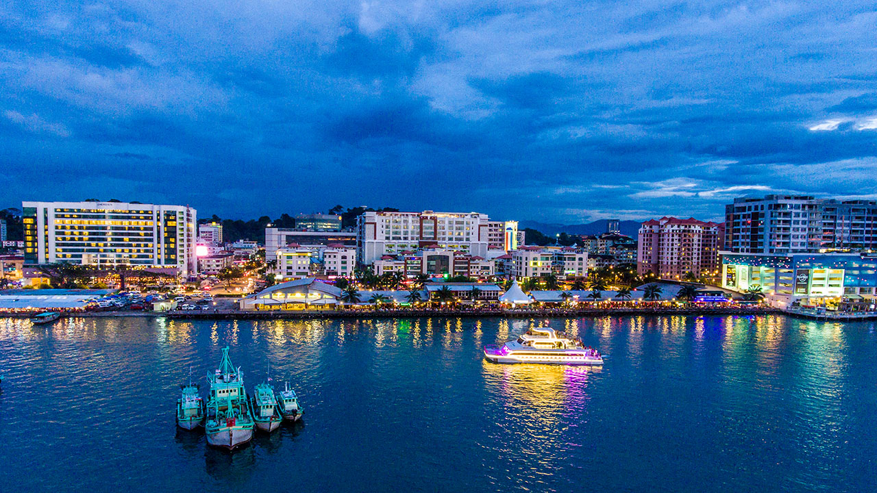
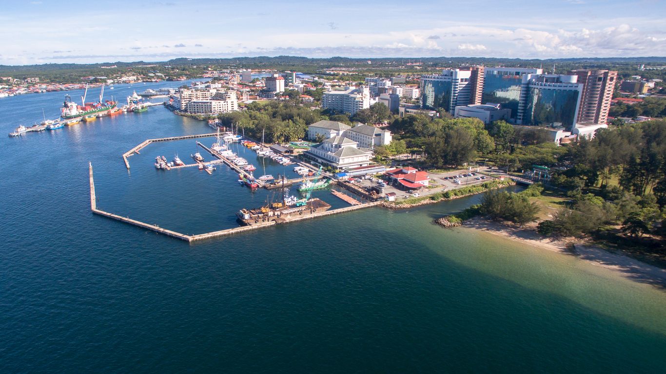
Travel Bucket List: Malaysia Part 53 – Sabah Part 2

Kota Kinabalu
Affectionately known as KK, Kota Kinabalu, Sabah’s capital was formerly known as Jesselton. The city is located on the northwest coast of Borneo facing the South China Sea. The Tunku Abdul Rahman National Park lies to its west and Mount Kinabalu, which gave the city its name, is located to its east.

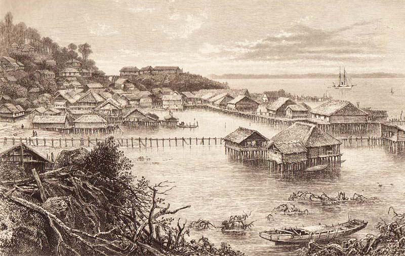
In the 15th century, the area of Kota Kinabalu was under the influence of the Bruneian Empire. Historically, the Kadazandusuns called the area by the name of Dondoung. In the 19th century, the British North Borneo Company, BNBC first set up a settlement near Gaya Island. However, it was destroyed by fire in 1897 by a local leader named Mat Salleh. In July 1899, the place located opposite Gaya Island was identified as a suitable place for settlements. Development in the area was started soon after that; and the place was named Api-api before it was renamed after Sir Charles Jessel, the vice-chairman of BNBC, as Jesselton. Jesselton became a major trading port in the area and was connected to the North Borneo Railway. Jesselton was largely destroyed during World War II. The Japanese occupation of Jesselton provoked several local uprisings notably the Jesselton Revolt but they were eventually defeated by the Japanese. After the war, BNBC was unable to finance the high cost of reconstruction and the place was ceded to the British Crown Colony. The British Crown declared Jesselton as the new capital of North Borneo in 1946 and started to rebuild the town. After the formation of Malaysia, North Borneo was renamed as Sabah. In 1967, Jesselton was renamed Kota Kinabalu, Kota being the Malay word for City and Kinabalu after the nearby Mount Kinabalu. Kota Kinabalu was granted city status in 2000.

Kota Kinabalu is a major tourist destination and a gateway for travellers visiting Sabah and Borneo. Kota Kinabalu is named after Mount Kinabalu, which is situated about 50 kilometres east-northeast of the city. Kinabalu is derived from the name Aki Nabalu meaning the revered place of the dead. Aki means ancestors or grandfather, and Nabalu is a name for the mountain in the Dusun language. There is also a source claiming that the term originated from Ki Nabalu, Ki meaning have or exist, and Nabalu meaning the spirit of the dead. The word kota comes from Malay word kota which in turn comes from the Sanskrit word kota which means fort, fortress, castle, fortified house, fortification, works, city, town, or place encircled by walls. A direct translation of the name Kota Kinabalu into English would be the City of Kinabalu or Kinabalu City.

Besides Jesselton, there are also other older names for Kota Kinabalu. The most popular is Api-Api, or simply Api, which is a Malay word meaning Fire. Another suggested historical name is Deasoka, which roughly means below the coconut tree in the Bajau language. The Bajau locals purportedly used this name to refer to a village in the southern part of the city which was filled with coconut trees. Yet another name was Singgah Mata which means transit eye, but can be loosely translated as pleasing to the eye. It is a name said to have been given by fishermen from Gaya Island referring to the strip of land that is today’s downtown Kota Kinabalu. Today, all these names have been immortalised as names of streets or buildings around the city.

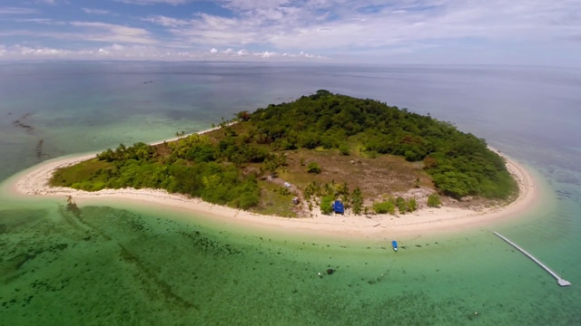
Kota Kinabalu is located on the west coast of Sabah. The city lies on a narrow flatland between the Crocker Range to the east and the South China Sea to the west. There are six islands off the coast of the city. The largest is Gaya Island, the site of the first British settlement. Approximately 8,000 people live there. The smaller islands, mainly uninhabited, are named Sapi Island, Manukan Island, Sulug Island, Mamutik Island and Sepanggar Island to the north. Sepanggar Island is located north of the National Park opposite Sepanggar Bay.

Besides being the capital city, Kota Kinabalu is also the main industrial and commercial centre for Sabah. The economy is dominated by the primary sector of industry. Historically, the secondary sector dominated the economy, but due to rapid urbanisation and economic development, this sector of the economy is slowly diminishing. More recently, a move towards a more tertiary-based industry has become more apparent, especially with the boom in the tourism industry.

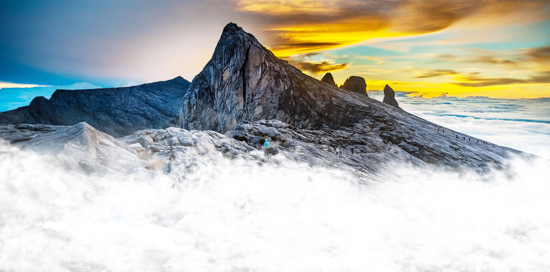
Malaysia’s highest mountain, known as Gurung Kinabalu in Malay, Gayo Ngaran or Nulu Nabalu in Dusun, Mount Kinabalu is protected as Kinabalu Park, a World Heritage Site. Standing at a height of 4,101 m, this is the most accessible mountain in the world. The mountain and its surroundings are among the most important biological sites in the world, with between 5,000 and 6,000 species of plants, 326 species of birds, and more than 100 mammalian species identified. Mount Kinabalu has been accorded UNESCO World Heritage status.

Low’s Peak can be climbed by a person in good physical condition and there is no need for mountaineering equipment at any point on the main route, but climbers must be accompanied by accredited guides at all times due to national park regulations and may experience altitude sickness. Its vast altitude allows a wide array of habitats to thrive and is one of the world’s most important biological sites.

The climate of the mountain varies from humid tropical at its base to alpine at its summit. Due to the coldness of the mountain from December to January, there are a few occasions where frost and ice appear at the summit of Mount Kinabalu. Snow has been recorded three times in this area; in 1975, 1993 and 2022.

Mount Kinabalu gets its name from the Kadazan word Aki Nabalu which translates to the revered place of the dead. Mount Kinabalu is sacred to the locals as they believe that the spirits of their ancestors occupy the peak of the mountain. Initially, every time someone tried to climb the mountain, a chicken was sacrificed to pacify the spirits. However, this ritual takes place only once a year where seven chickens are sacrificed to pacify the spirits. Another popular legend among the locals is that the mountain belongs to a Chinese Widow. The legend says that a Chinese prince married a Kadazan woman after he defeated a dragon. However, soon after his marriage, he left for China thus abandoning the Kadazan woman. The woman then headed into the mountains where she was later turned to stone.

Ascending and descending the mountain can take up to 4 hours. However, visitors generally take two days with an overnight stay at Laban Rata, which is located 3,272 meters above sea level. Visitors generally try to reach the peak of the mountain by sunrise to catch the beautiful sun and capture sensational pictures.

The entry fee to enter Kinabalu Park is RM 15 for adults and RM 10 for children. A climb fee permit is charged at RM 200 for foreigners and RM 50 for Malaysians. A maximum of 120 people are allowed to climb the mountain each day to preserve the environment and for safety measures. Climbing permits are subject to availability so visitors are recommended to book their climbing packages in advance. Permits for the climb can be obtained from the tour guides or agencies. The cost of hiring mountain guide services is RM 230, while the porter service per day is RM 65.

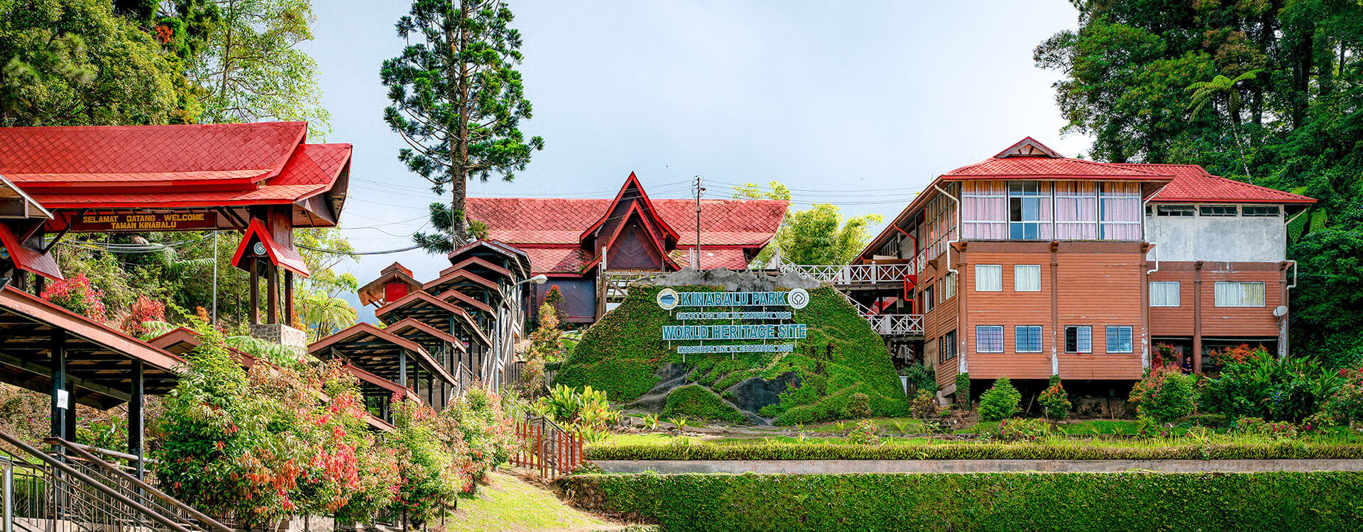
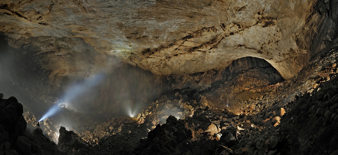
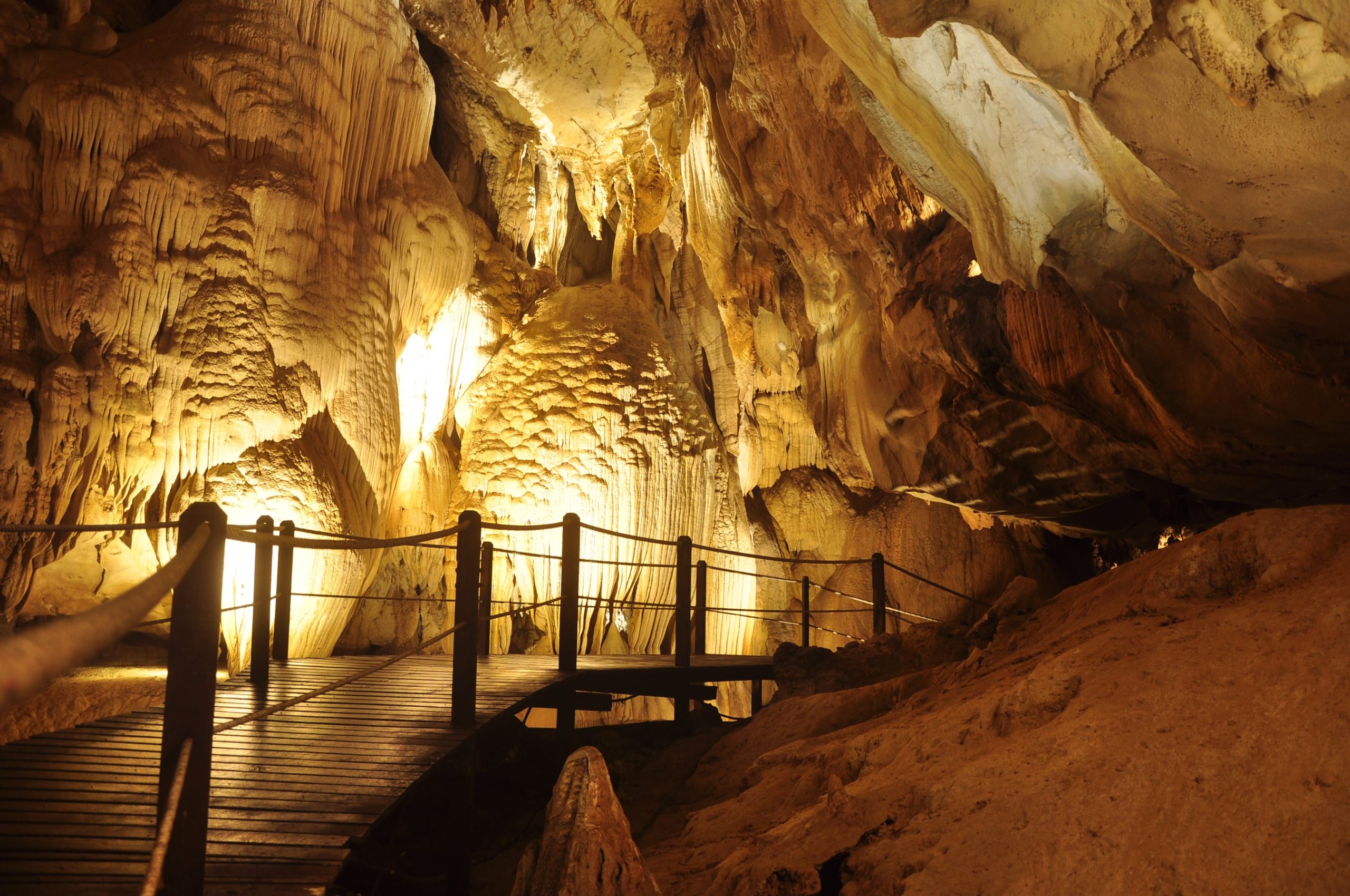
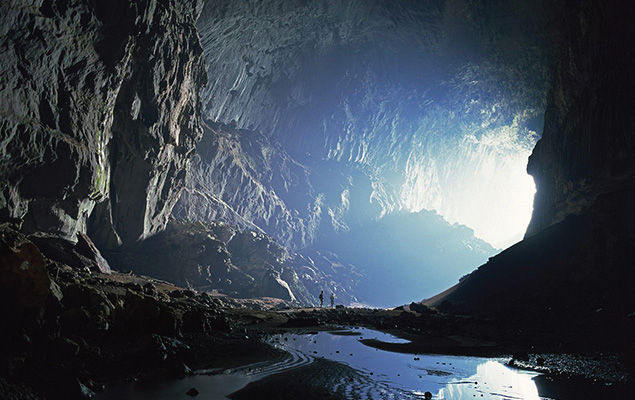
Malaysia’s first national park, Kinabalu Park was opened to the public in 1964 and is today a UNESCO World Heritage Site by UNESCO. The park is buzzing with plant species such as the alpine meadow plants and montane oak.

It is one of the most important biological sites in the world with more than 4,500 species of flora and fauna, including 326 bird and around 100 mammal species, and over 110 land snail species. It covers an area of 754 sq km surrounding Mount Kinabalu, which is the highest mountain in Borneo.

The park contains a variety of flora and fauna that ranges over 4 climate zones; from rich lowland dipterocarp forest through the montane oak, and rhododendron, to the coniferous forests, to the alpine meadow plants, and the stunted bushes of the summit zone. The mountain is also known for its many carnivorous plants and orchid species, most notably Nepenthes rajah. It is also home to a multitude of endemic animal species, including the Kinabalu giant red leech and Kinabalu giant earthworm. The park also plays host to a variety of birds, insects, mammals, amphibians, and reptiles.

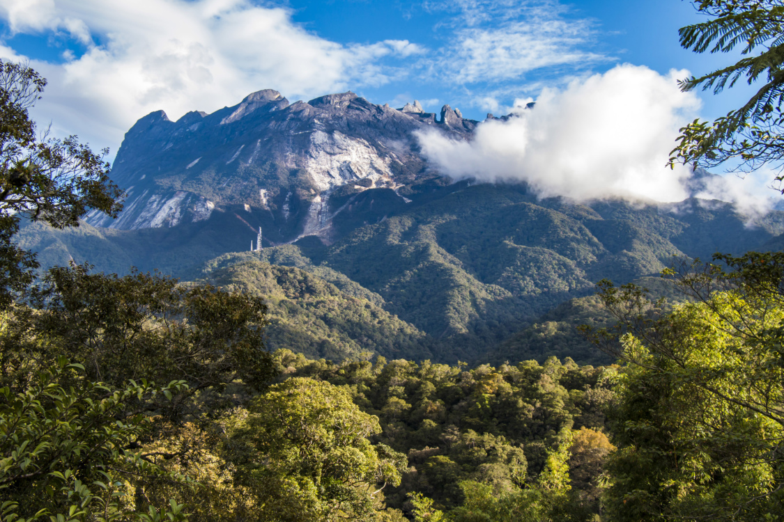
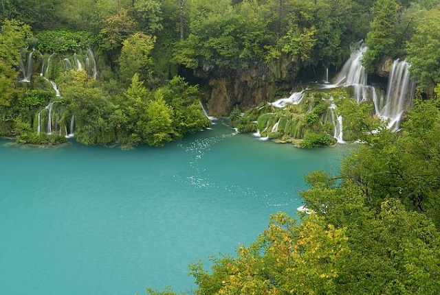
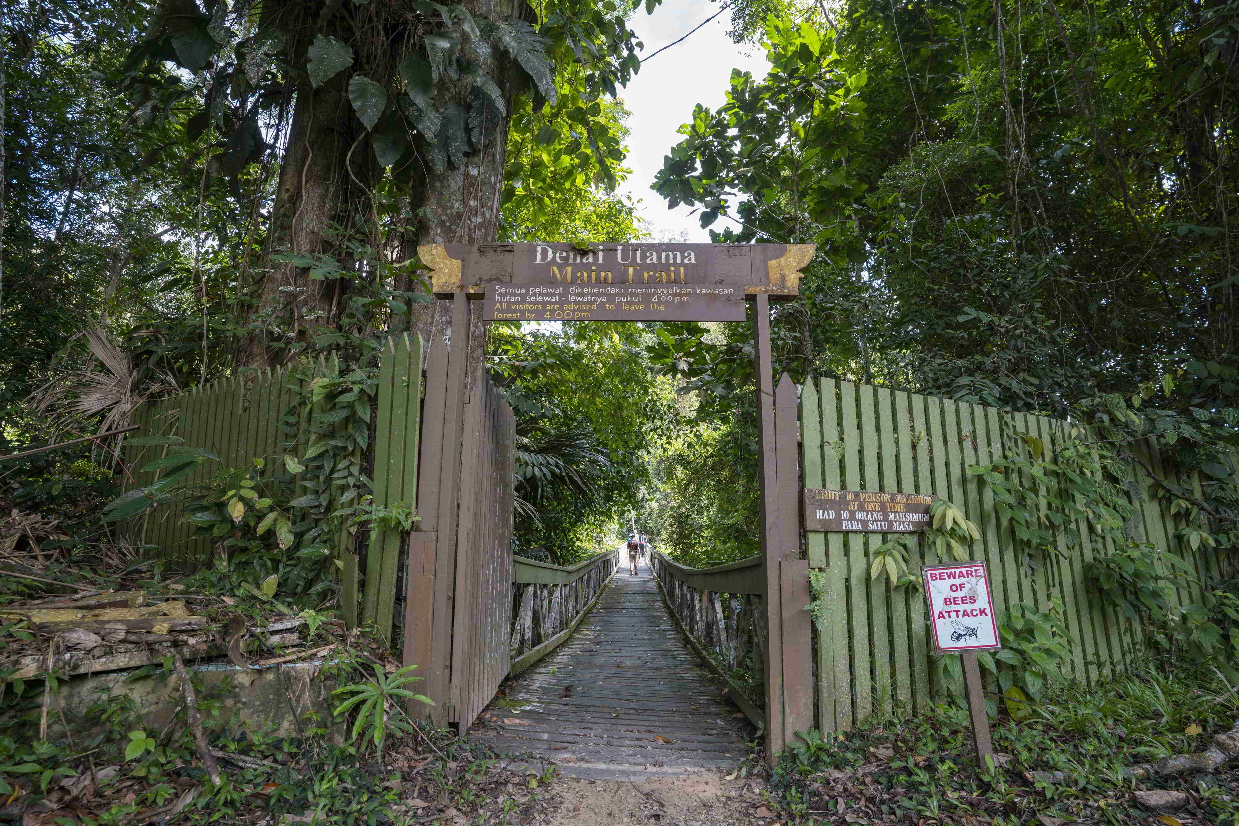
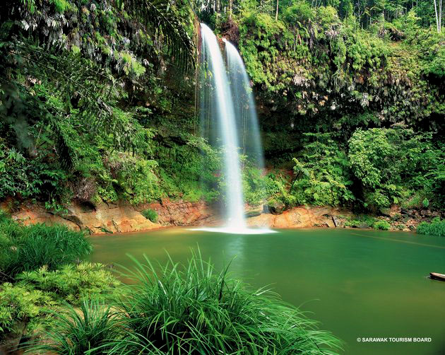
Mount Kinabalu is one of the youngest non-volcanic mountains in the world. It was formed within the last 10 to 35 million years. The mountain still grows at a rate of 5 millimetres a year. Kinabalu Park has eight nature trails for visitors who want to explore nature without trekking the mountain. There are several other attractions in the park such as the Orchid Conservation Center and the Butterfly Farm which will be an educative experience. One should not miss the waterfalls in the park, Kipungit Waterfall and Langanan Waterfall. The latter stands at 120m high and is a sight to behold.

April is the most preferred month for climbing the mountain as the weather is stable and is more suited for climbing. Visitors are advised to avoid climbing the mountain during November and December, as these months witness heavy rainfall which can make climbing difficult and dangerous.

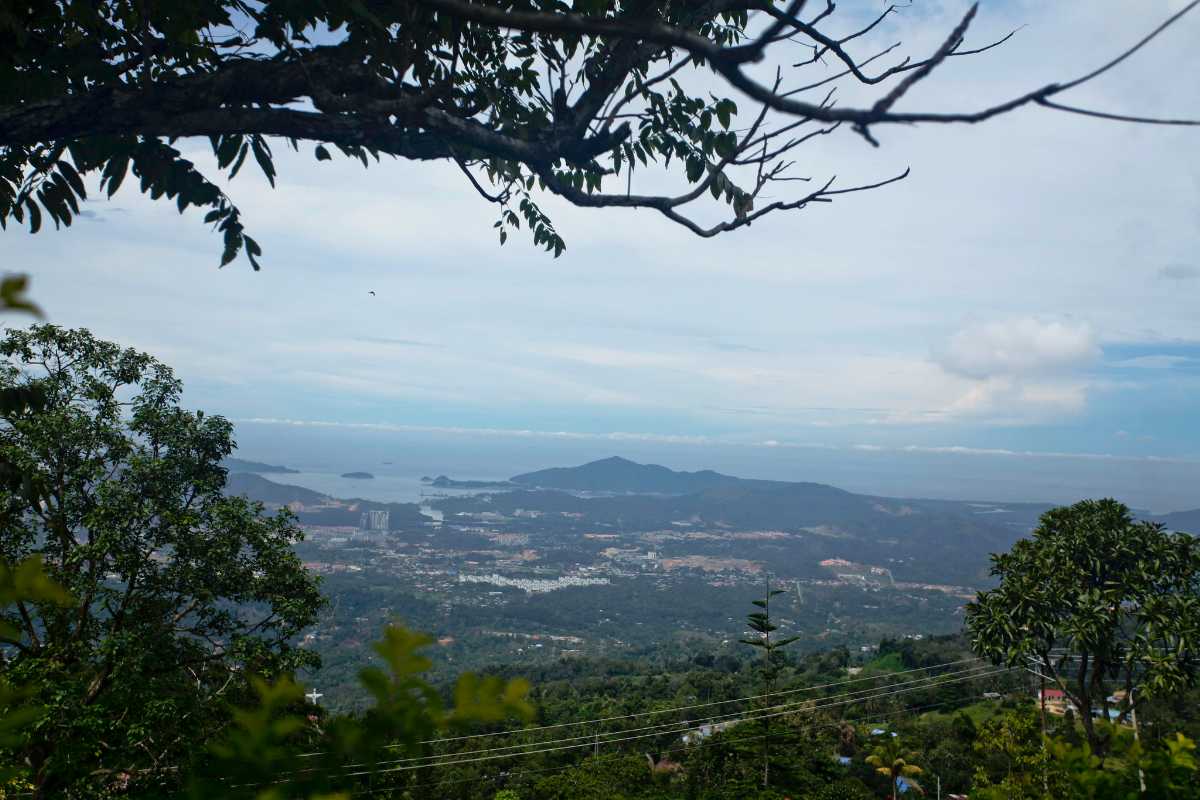
Standing at 800 m above sea level, Kokal Hill is popular for its mesmerising city view, cool and fresh air, chilly temperatures and relaxing atmosphere. To get to the panoramic view, one needs to hike to the top which has resorts, cafes, homestays and a perfect location for landscape photography. Kokol Hill experiences a cool and pleasant climate mostly and is very crowded on clear days. It is best to visit around 6 am and in the evenings to experience the beautiful sunrise and sunset respectively.

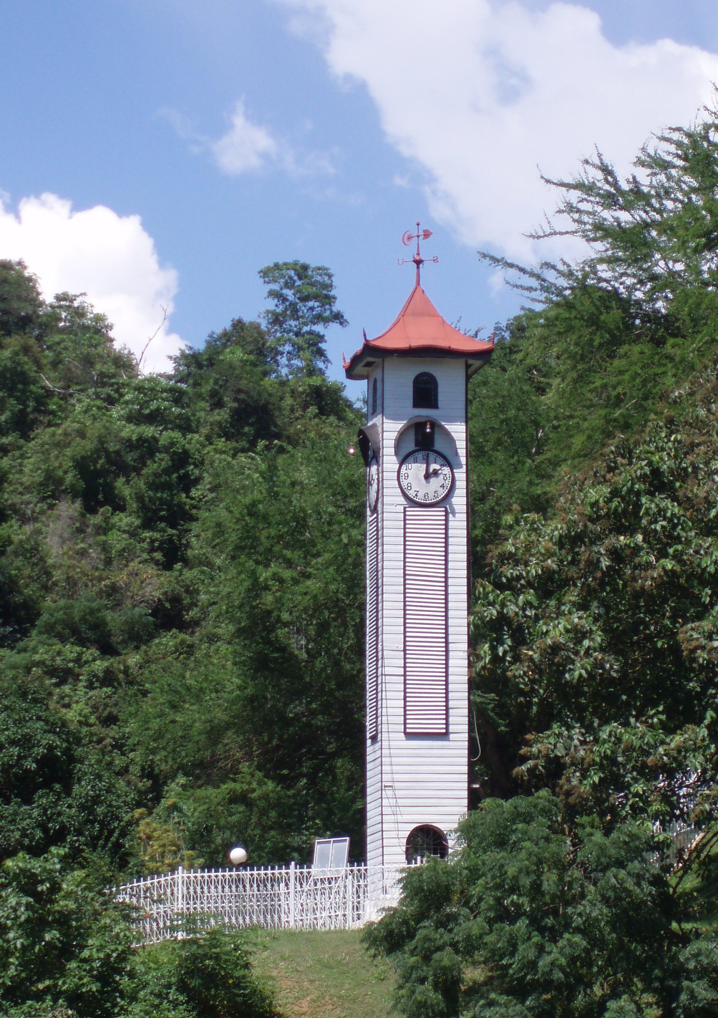
The oldest standing structure in Kota Kinabalu, the Atkinson Clock Tower was originally known as the Atkinson Memorial Clock Tower and sits in solitary on the bluff along Signal Hill Road. The clock tower was built in memory of Francis George Atkinson, Jesselton’s first district officer who died of Malaria or Borneo Fever. His mother Mrs Mary Edith Atkinson presented a two-faced clock to Jesselton town as a tribute to the memory of her son and it was decided later that a clock tower would be built in his honour. The clock tower was originally built using Mirabau wood. Measuring 50 feet high, the clock tower stood from its lookout point on the hill facing towards the township of Jesselton. A weather vane with initials of the wind direction added a few more inches to the height of this elegant monument. Ships calling port at the wharf used the Atkinson Clock Tower as their navigation landmark, as it could be seen from the sea. The clock tower was illuminated at night and was used as a shipping landmark right up to the 1950s.  

Over the years, the clock tower underwent many transformations. Subsequent repairs and renovations have altered its appearance. Japanese machine-gun fire during World War 2 damaged the dial and cog of the clock tower’s mechanisms. The clock tower was extensively renovated and altered for Jesselton’s Diamond Jubilee celebrations in 1959. In 1961, the Atkinson Clock Tower’s clock face was altered yet again. The dials of the clock were changed and the face was replaced with translucent Perspex, with black figures on a white background for internal lighting. But the building itself has remained intact in its exact location for more than a century. The clock tower is protected with its site gazetted in 1983.

A cluster of traditional homes, the Mari Mari Cultural Village is popular for its tours and traditional art and craft displays. Murut, Dusun, Bajau and more are the communities scattered around Jin Kiansom, in Kota Kinabalu. One can witness tattoo-making, blow-pipe making and other indigenous crafts that these tribes engage in, as well as sample their cuisine and learn about their lifestyles and beliefs. While here, make sure to visit the Kiansom Waterfall which is close to the village.

The tour of the Mari Mari Cultural Village takes one through the vast area inhabited by the members of 5 different tribal communities. One can witness the various traditional activities and habits followed by each of these distinct tribes and their daily routines and rituals. Some of the fun activities included in the Mari Mari Tour include rice wine tasting, a unique method of cutting trees and blowpipe dart shooting which was once used as a means of defensive weapon but has now been turned into a harmless entertaining game. One can also volunteer for their special folk music and tribal ethnic dances like the Magunatip bamboo dance performed by the Murut tribes.

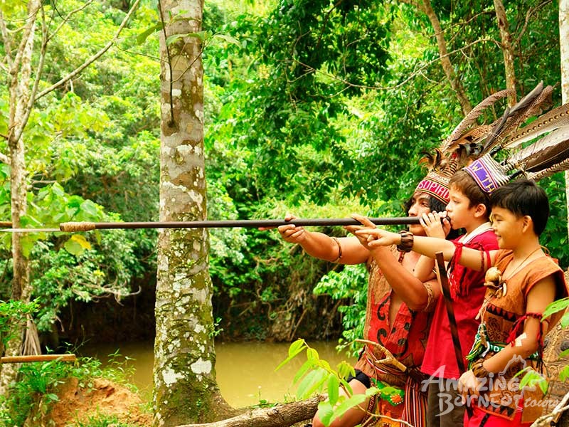
The Murut Tribe is one of the oldest tribal communities residing in the Mari Mari Village. They used to have quite a dominant grasp over the other tribes residing in and around the area due to their headhunting practices. They were also well-known for their fatal weapons like poisoned blowpipes, swords and ribbed spears coated with venom. One of their ancient traditions involved strategically placing the skeleton heads of those sacrificial humans to display their might to the neighbouring tribes and preventing any attempts of attacks or threats to the members of their tribe. However, after British colonisation, their population started decreasing rapidly and they became more domesticated leading them to turn into one of the friendlier tribes of the current times.

The Lundayeh Tribe, also called the Lun Bawang tribe, are a hard-working community of fishermen, livestock farmers, hunters and fishermen. They were infamous for their hardcore burak or rice wine drinking habits. In the early 20th century, there was a major smallpox epidemic which wiped out most of the Lundayeh tribe members. This was mainly due to their low immunity caused due to excessive drinking which made them more vulnerable to any kind of outbreaks. Today, the Lundayeh are considered almost extinct.

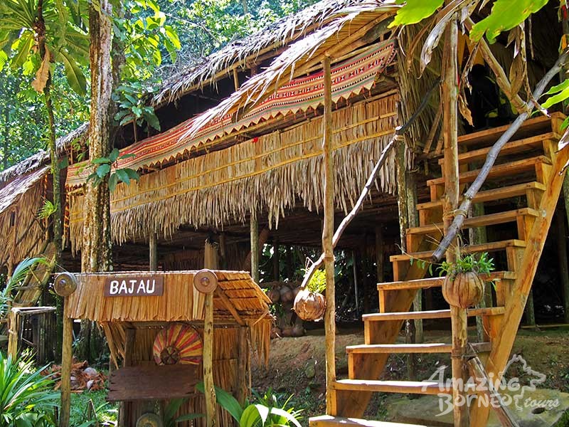
The Bajau tribal community has two subdivisions – about half of them residing in Kota Belud and the other half in Sempora. The Bajau tribes of Kota Belud are popularly known as the Cowboys of the East due to their skilled horse breeding and horse riding abilities. The Bajau Laut tribes of Semporna are fondly known as Sea Cusps due to their proficient sailing skills.

The Kadazan tribe is truly the people of the land. They cherish their produce and celebrate Kaamatan annually which they consider to be one of the most auspicious harvest festivals to honour and thank the agricultural deities. Most of the Kadazans are Christians, mainly Roman Catholics and a minority community of Protestants and Islamic followers.

The Rungus tribe was earlier considered to be a sub-community of the bigger Kadazan ethnic group until recently when they were declared to be a separate, independent tribal community that happened to be heavily influenced by Malaysian society. The entire community is quite heavily dependent upon rice harvest and processing making it their main source of income.

The cultural village is open from 10 am to 6 pm daily. Entry fees are RM 180 for adults RM 160 for children between the ages of 5 and 11.

The Japanese thermal pools at the Poring Hot Springs are part of the Kinabalu National Park and are a perfect way to relax after an exhaustive trek on Mount Kinabalu. The natural hot springs and the baths contain sulphur which is known for its skin-curative and restorative properties. The complex also has an enchanting forest filled with life, where a lucky few might even get to see some rare flora or fauna like the Rafflesia flower which only blooms rarely. Poring Hot Springs makes for a great trip for anyone looking for some adventure and the chance to attune to oneself.

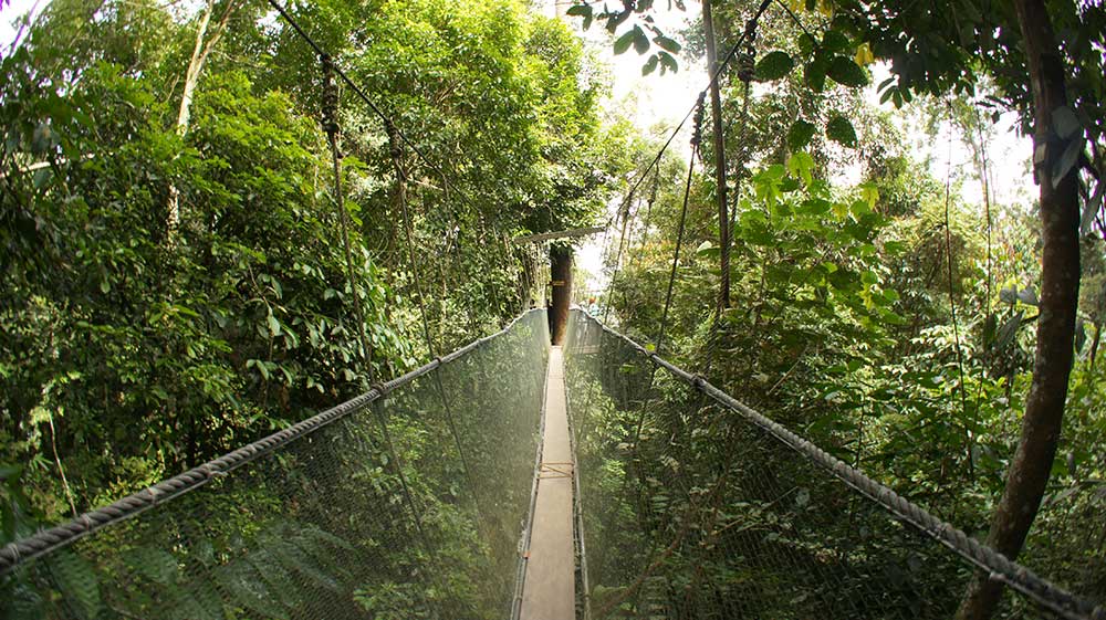
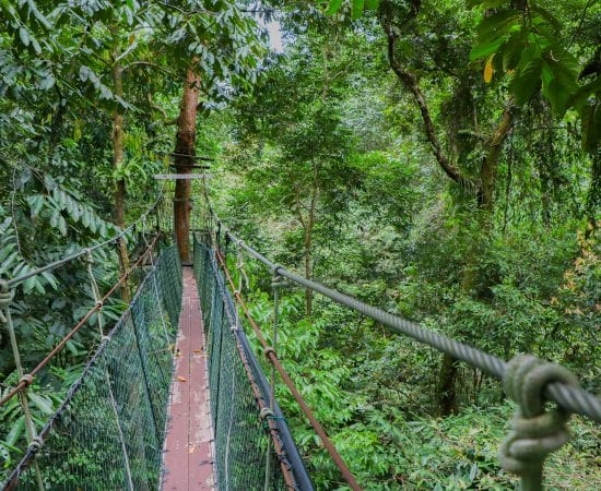
The Poring Canopy Walk offers a chance to have a thrilling bird’s eye view of the entire spring complex from a height of 30 metres. It consists of a series of walkways suspended from trees in a circular shape. Visitors can opt to undertake an unguided trek through the forest complex to the Kipungit and Langanan waterfalls. The park complex also houses a beautiful butterfly park, located en route to the canopy walk. Another attraction for lovers of flora and fauna is the orchid garden within the park, home to a wide variety of orchids and also certain kinds of animals. The forest also has activities like bird watching that are highly enjoyable. The spring is open daily from 8 am to 6 pm.

The Kota Kinabalu City Mosque is the largest and second main mosque in Kota Kinabalu. Surrounded by a man-made lagoon, it is popularly known as the Floating Mosque because it appears to be floating on the water. The mosque is believed to be an epitome of Islamic architecture having been built in the lines of the Mosque Of Nabawi Al-Munawwara. It consists of a huge prayer hall along with three distinct madrasahs or Islamic schools with the capacity of accommodating up to 12,000 people at a time. Visitors are permitted to enter the mosque and look through it, however, they must register themselves with the Kota Kinabalu City Mosque Tourism Management first.

The dome of the mosque is striking and resplendent in gold and blue colours with the structure resembling Al Masjid an Nabawi, the second holiest mosque in the world. It is surrounded by an artificial lagoon that gave it the name of the floating mosque. Apart from 3 madrasahs and a prayer hall, a palliative care clinic as well as a fish farm. The mosque also introduced paddle boat rides for visitors in 2008. The mosque is open from 8 am to 12 noon and then again between 2 to 3:30 pm and 4 to 5:30 pm. It is closed on Fridays, but open all other days. Entry is free for Malaysians, but foreigners need to pay RM 5.

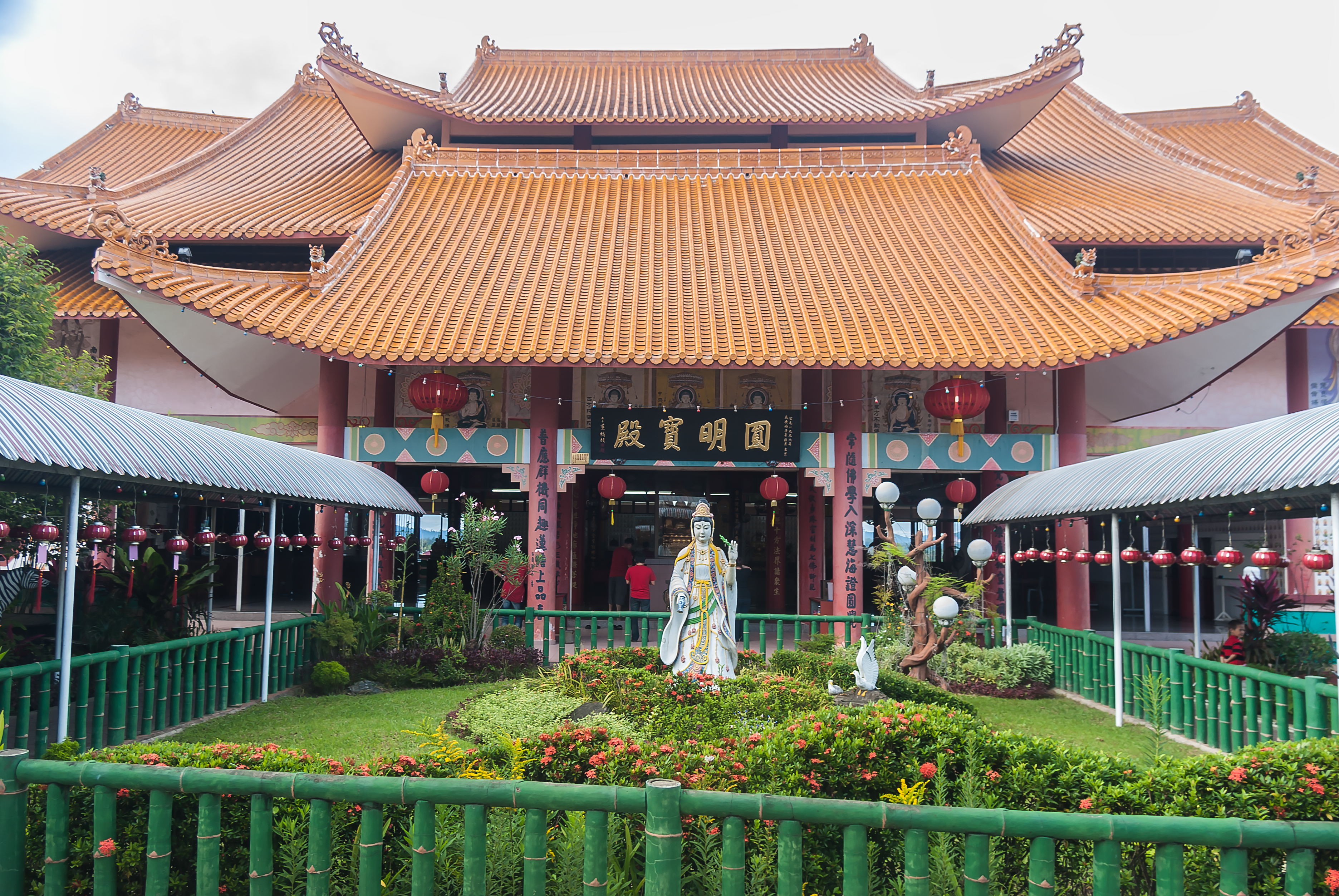
The Puh Toh Tze Temple is one of the most popular Buddhist temples in the country. The temple is adorned with traditional carvings and sculptures of the local deities. Built in the late 21st century, the temple was constructed to pay respect to and worship the Chinese goddess Kwan Yin, the Goddess of Mercy and Compassion, who is considered to be one of the most influential goddesses in the kingdom of Chinese deities. The architecture of this temple has gained its inspiration from the traditional Chinese designs and patterns making it one of the most popular tourist attractions at Kota Kinabalu. There are several intricate features in the temple. A massive stone staircase pavilion is flanked by statues of 10 deities on either side. However, the statue of Kwan Yin which greets visitors right as they cross the main entrance captivates their attention and dominates over the rest of the statues. Inside the temple is a huge Chinese laughing Buddha statue with miniature followers clinging onto him giving the statue a humorous touch. The walkway of Puh Toh Tze Temple houses the giant bell which is believed to have brought about good fortune to anyone who rings it.

Travel Bucket List: Malaysia Part 52 – Sabah Part 1

Located in the northernmost part of Borneo, Sabah has land borders with Sarawak to the southwest and Indonesia’s North Kalimantan province to the south. The Federal Territory of Labuan is an island just off Sabah’s west coast. Sabah shares maritime borders with Vietnam to the west and the Philippines to the north and east. Kota Kinabalu is the state capital, the economic centre of the state, and the seat of the Sabah State government. Other major towns in Sabah include Sandakan and Tawau. Sabah has an equatorial climate with tropical rainforests, abundant with animal and plant species. The state has long mountain ranges on the west side, which form part of Crocker Range National Park. The Kinabatangan River, the second longest river in Malaysia, runs through Sabah. The highest point of Sabah, Mount Kinabalu, is also the highest point in Malaysia.

The origin of the name Sabah is uncertain, and many theories have arisen. One theory is that during the time it was part of the Bruneian Sultanate, it was referred to as Saba because of the presence of a variety of banana called pisang saba, also known as pisang menurun, which is grown widely on the coast of the region and popular in Brunei. The Bajau community referred to it as pisang jaba. While the name Saba also refers to a variety of bananas in both Tagalog and Visayan languages, the word in Visayan has the meaning noisy, which in turn is derived from Sanskrit Sabhā, meaning a congregation, or crowd and related to a noisy mob. Due to the local dialect, the word Saba has been pronounced as Sabah by the local community. While Brunei was a vassal state of Majapahit, the Old Javanese eulogy of Nagarakretagama described the area in what is now Sabah as Seludang.

Although the Chinese have been associated with the island since the days of the Han dynasty, they did not have any specific names for the area. Instead, during the Song dynasty, they referred to the whole island as Po Ni, also pronounced Bo N), which is the same name they used to refer to the Sultanate of Brunei at the time. Due to the location of Sabah near Brunei, it has been suggested that Sabah was a Brunei Malay word meaning upstream or in a northerly direction. Another theory suggests that it came from the Malay word sabak, which means a place where palm sugar is extracted. Sabah is also an Arabic word, which means morning.

The presence of multiple theories makes it difficult to pinpoint the true origin of the name. It is nicknamed the Land Below the Wind or Negeri Di Bawah Bayu, as the state lies below the typhoon belt of East Asia and has never been battered by any typhoons, except for several tropical storms.

The earliest known human settlement in the region existed 20,000–30,000 years ago, as evidenced by stone tools and food remains found by excavations along the Darvel Bay area at Madai-Baturong caves near the Tingkayu River. In 2003, archaeologists discovered the Mansuli valley in the Lahad Datu District, which dates back the history of Sabah to 235,000 years. During the 7th century, a settled community known as Vijayapura, a tributary to the Srivijaya empire, was thought to have existed in northwest Borneo. The earliest independent kingdom in Borneo, supposed to have existed in the 9th century, was Po Ni, as recorded in the Chinese geographical treatise Taiping Huanyu Ji. It was believed that Po Ni existed at the mouth of the Brunei River and was the predecessor to the Bruneian Empire.

In the 14th century, Brunei and Sulu were part of the Majapahit Empire but in 1369, Sulu and the other Philippine kingdoms successfully rebelled and Sulu even attacked Brunei, which was still a Majapahit tributary. The Sulus specifically invaded Northeast Borneo at Sabah. The Sulus were repelled but Brunei became weakened. In 1370, Brunei transferred its allegiance to the Ming dynasty of China. The Maharaja Karna of Borneo then paid a visit to Nanjing with his family until his death. He was succeeded by his son, Hsia-wang, who agreed to send tribute to China once every three years. After that, Chinese junks came to northern Borneo with cargoes of spices, bird nests, shark fins, camphor, rattan and pearls. More Chinese traders eventually settled in Kinabatangan, as stated in both Brunei and Sulu records. A younger sister of Ong Sum Ping or Huang Senping, the governor of the Chinese settlement, then married Sultan Ahmad of Brunei. Perhaps due to this relationship, a burial place with 2,000 wooden coffins, some estimated to be 1,000 years old, was discovered in the Agop Batu Tulug Caves and around the Kinabatangan Valley area. It is believed that this type of funeral culture was brought by traders from Mainland China and Indochina to northern Borneo as similar wooden coffins were also discovered in these countries.

During the reign of the fifth sultan of Bolkiah between 1485 and 1524, the Sultanate’s thalassocracy extended over northern Borneo and the Sulu Archipelago, as far as Kota Seludong, present-day Manila, with its influence extending as far as Banjarmasin, taking advantage of maritime trade after the fall of Malacca to the Portuguese. Many Brunei Malays migrated to Sabah during this period, beginning after the Brunei conquest of the territory in the 15th century. But plagued by internal strife, civil war, piracy and the arrival of Western powers, the Bruneian Empire began to shrink. The first Europeans to visit Brunei were the Portuguese, who described the capital of Brunei at the time as surrounded by a stone wall. The Spanish followed, arriving soon after Ferdinand Magellan’s death in 1521, when the remaining members of his expedition sailed to the islands of Balambangan and Banggi in the northern tip of Borneo. Later, in the Castilian War of 1578, the Spanish, who had sailed from New Spain, which was centred in Mexico and had taken Manila from Brunei, unsuccessfully declared war on Brunei by briefly occupying the capital before abandoning it. The Sulu region gained its independence in 1578, forming its sultanate, known as the Sultanate of Sulu.

When the civil war broke out in Brunei between Sultans Abdul Hakkul Mubin and Muhyiddin, the Sulu Sultan asserted their claim to Brunei’s territories in northern Borneo. The Sulus claimed that Sultan Muhyiddin had promised to cede the northern and eastern portions of Borneo to them in compensation for their help in settling the civil war. The territory seems never to have been ceded formally, but the Sulus continued to claim the territory, with Brunei weakened and unable to resist. After the war with the Spanish, the area in northern Borneo began to fall under the influence of the Sulu Sultanate. The seafaring Bajau-Suluk and Illanun people then arrived from the Sulu Archipelago and started settling on the coasts of north and eastern Borneo, fleeing from the oppression of Spanish colonialism. While the thalassocratic Brunei and Sulu sultanates controlled the western and eastern coasts of Sabah, respectively, the interior region remained largely independent from either kingdom. The Sultanate of Bulungan’s influence was limited to the Tawau area, which came under the influence of the Sulu Sultanate before gaining its own rule after the 1878 treaty between the British and Spanish governments.

In 1761, Alexander Dalrymple, an officer of the British East India Company, agreed with the Sultan of Sulu to allow him to set up a trading post for the first time in northern Borneo, although this was to prove a failure. Following the British occupation of Manila in 1763, the British freed Sultan Alimuddin from Spanish colonisers and allowed him to return to his throne; this was welcomed by the Sulu people and by 1765, Dalrymple managed to obtain the island, having concluded a Treaty of Alliance and Commerce with the Sultan of Sulu by a willing Sultan Alimuddin as a sign of gratitude for the British aid. A small British factory was then established in 1773 on Balambangan Island, a tiny island situated off the north coast of Borneo. The British saw the island as a suitable location to control the trade route in the East, capable of diverting trade from the Spanish port of Manila and the Dutch port of Batavia, especially with its strategic location between the South China Sea and Sulu Sea. The British abandoned the island two years later when the Sulu pirates began attacking. This forced the British to seek refuge in Brunei in 1774 and to temporarily abandon their attempts to find alternative sites for the factory. Although an attempt was made in 1803 to turn Balambangan into a military station, the British did not re-establish any further trading posts in the region until Stamford Raffles founded Singapore in 1819.

In 1846, the island of Labuan on the west coast of Sabah was ceded to Britain by the Sultan of Brunei through the Treaty of Labuan, and in 1848 it became a British Crown Colony. Seeing the presence of the British in Labuan, the American consul in Brunei, Claude Lee Moses, obtained a ten-year lease in 1865 for a piece of land in northern Borneo. Moses then passed the land to the American Trading Company of Borneo, which chose Kimanis, which they renamed Ellena, and started to build a base there. Requests for financial backing from the US government proved futile and the settlement was later abandoned.

Japanese forces landed in Labuan on January 3, 1942 and later invaded the rest of northern Borneo. From 1942 to 1945, Japanese forces occupied North Borneo, along with most of the rest of the island, as part of the Empire of Japan. The occupation drove many people from coastal towns to the interior, fleeing the Japanese and seeking food. As part of the Borneo Campaign to retake the territory, Allied forces bombed most of the major towns under Japanese control, including Sandakan, which was razed to the ground. The Japanese ran a brutal prisoner-of-war camp known as Sandakan Camp for those siding with the British. The majority of the POWs were British and Australian soldiers captured after the fall of Malaya and Singapore. The prisoners suffered notoriously inhuman conditions, and amidst continuous Allied bombardments, the Japanese forced them to march into Ranau, which is about 260 kilometres away, in an event known as the Sandakan Death March. In March 1945, Australian forces launched Operation Agas to gather intelligence in the region and launch guerrilla warfare against the Japanese. The war ended on September 10, 1945, after the Australian Imperial Forces or AIF succeeded in the battle of North Borneo.

After the Japanese surrender, North Borneo was administered by the British Military Administration and, on July 15, 1946, became a British Crown Colony. The Crown Colony of Labuan was integrated into this new colony. Due to massive destruction in the town of Sandakan since the war, Jesselton was chosen to replace the capital and the Crown continued to rule North Borneo until 1963. Upon Philippine independence in 1946, seven of the British-controlled Turtle Islands, including Cagayan de Tawi-Tawi and Mangsee Islands off the north coast of Borneo, were ceded to the Philippines as part of negotiations between the American and British colonial governments. On August 31, 1963, North Borneo attained self-government. After discussion culminating in the Malaysia Agreement and 20-point agreement, on September 16, 1963, North Borneo as Sabah was united with Malaya, Sarawak and Singapore, to form the independent Malaysia.

From before the formation of Malaysia until 1966, Indonesia adopted a hostile policy towards the British-backed Malaya, leading after the union to the Indonesia-Malaysia confrontation. This undeclared war stemmed from what Indonesian President Sukarno perceived as an expansion of British influence in the region and his intention to wrest control over the whole of Borneo under the Greater Indonesia concept. Meanwhile, the Philippines, beginning with President Diosdado Macapagal on Ju, June 1962, claimed Sabah from cession by heirs of the Sultanate of Sulu. Macapagal, who considered Sabah to be the property of the Sultanate of Sulu, saw the attempt to integrate Sabah, Sarawak and Brunei into the Federation of Malaysia as trying to impose the authority of Malaya on these states.

Sabah held its first state election in 1967. In the same year, the state capital of Jesselton was renamed Kota Kinabalu. On June 14, 1976, the state government of Sabah signed an agreement with Petronas, granting it the right to extract and earn revenue from petroleum found in the territorial waters of Sabah in exchange for 5% in annual revenue as royalties based on the 1974 Petroleum Development Act. The state government of Sabah ceded Labuan to the Malaysian federal government, and Labuan became a federal territory on April 16, 1984. In 2000, the state capital, Kota Kinabalu, was granted city status, making it the 6th city in Malaysia and the first city in the state.

In February 2013, Sabah’s Lahad Datu District was penetrated by followers of Jamalul Kiram III, the self-proclaimed Sultan of the Sulu Sultanate. In response, Malaysian military forces were deployed to the region, following which an Eastern Sabah Security Command was established. Sabah has seen several territorial disputes with Malaysia’s neighbours, Indonesia and the Philippines. In 2002, both Malaysia and Indonesia submitted to arbitration by the ICJ on a territorial dispute over the Ligitan and Sipadan islands, which was later won by Malaysia. There are also several other disputes yet to be settled with Indonesia over the overlapping claims on the Ambalat continental shelf in the Celebes Sea and the land border dispute between Sabah and North Kalimantan. Malaysia’s claim over a portion of the Spratly Islands is also based on sharing a continental shelf with Sabah. The Philippines has a territorial claim over much of the eastern part of Sabah. It claims that the territory is connected with the Sultanate of Sulu and was only leased to the North Borneo Chartered Company in 1878, with the Sultanate’s sovereignty never being relinquished. Malaysia, however, considers this dispute a non-issue, as it interprets the 1878 agreement as that of cession and deems that the residents of Sabah exercised their right to self-determination when they joined to form the Malaysian federation in 1963. Before the 2013 incident, Malaysia continued to dutifully pay an annual cession payment amounting to roughly $1,000 to the indirect heirs of the Sultan, honouring an 1878 agreement, where North Borneo, today’s Sabah, was conceded by the late Sultan of Sulu to a British company. However, the Malaysian government halted payments after this tragedy. As a result, the self-proclaimed Sulu heirs pursued this case for legal arbitration vis-à-vis the original commercial deal. Since then, Sulu claimants have been accused of forum shopping. In 2017, the heirs showed their intention to start arbitration in Spain and asked for $32.2 billion in compensation. In 2019, Malaysia responded for the first time. The attorney general at the time offered to start making yearly payments again and to pay RM 48,000 or about USD 10,400 for past dues and interest, but only if the heirs gave up their claim. The heirs did not accept this offer and the case, led by Spanish arbiter Gonzalo Stampa, continued without Malaysia being involved. In February 2022, Gonzalo Stampa awarded US$14.9 billion to the Sultan of Sulu’s heirs, who have since sought to enforce the award against Malaysian state-owned assets around the world. It is noteworthy that on 27 June 2023, the Hague Court of Appeal dismissed the Sulus’ bid and ruled in favour of the Malaysian government, which hailed the decision as a landmark victory.

The Philippine claim can be based on three historical events: the Brunei Civil War from 1660 until 1673, the treaty between the Dutch East Indies and the Bulungan Sultanate in 1850 and the treaty between Sultan Jamal ul-Azam and Overbeck in 1878. Further attempts by several Filipino politicians to destabilise Sabah proved to be futile and led to the Jabidah massacre in Corregidor Island, Philippines. This led the Malaysian government to support the insurgency in the southern Philippines. Although the Philippine claim to Sabah has not been actively pursued for some years, some Filipino politicians have promised to bring it up again, while the Malaysian government has asked the Philippines not to threaten ties over such an issue.

Sabah exhibits notable diversity in ethnicity, culture and language. It is known for its traditional musical instrument, the sompoton. Sabah has abundant natural resources, and its economy is strongly export-oriented. Its primary exports include oil, gas, timber and palm oil. The other major industries are agriculture and ecotourism. Sabah is located south of the typhoon belt, making it insusceptible to the devastating effects of the typhoons that frequently batter the neighbouring Philippines. The state is surrounded by the South China Sea in the west, the Sulu Sea in the northeast and the Celebes Sea in the southeast. Sabah’s 1,743 km of coastline faces erosion and because it is surrounded by three seas, it has extensive marine resources. The state coastline is covered with mangrove and nipah forests. Both coastal areas on the west coast and east coast are entirely dominated by sand beaches, while in sheltered areas the sand is mixed with mud. The western part of Sabah is generally mountainous, containing three of the highest peaks. The main mountain range is the Crocker Range, with several mountains of varying heights. Adjacent to the Crocker Range is the Trus Madi Range, with Mount Trus Madi, at a height of 2,642 m. The highest peak is Mount Kinabalu, at a height of 4,095 m. The central and eastern portions of Sabah are generally lower mountain ranges and plains with occasional hills. On the east coast is the Kinabatangan River, which is the second-longest river in Malaysia after the Rajang River in Sarawak, with a length of 560 km. Sabah experiences two monsoon seasons, the northeast and southwest. It also receives two inter-monsoon seasons, from April to May and September to October. As Sabah lies within the Sunda Plate with compression from the Australian and Philippine Plates, it is prone to earthquakes.

The kingfisher is the state bird of Sabah and is featured in one of its coats of arms. The Semporna Peninsula on the north-eastern coast of Sabah is identified as a hotspot of high marine biodiversity importance in the Coral Triangle. The jungles of Sabah host a diverse array of plant and animal species. Most of Sabah’s biodiversity is located in the forest reserve areas, which form half of its total landmass. Its forest reserves are part of the 20 million hectares of equatorial rainforests demarcated under the Heart of Borneo initiative. Kinabalu National Park was inscribed as a World Heritage Site by UNESCO in 2000 for its richness in plant diversity combined with its unique geological, topographical, and climatic conditions. The park hosts more than 4,500 species of flora and fauna, including 326 birds and around 100 mammal species, along with over 110 land snail species.

Since the post-World War II timber boom, driven by the need for raw materials from industrial countries, Sabah forests have been gradually eroded by uncontrolled timber exploitation and the conversion of Sabah forest lands into palm oil plantations. Since 1970, the forestry sector has contributed to over 50% of the state revenue, of which a study conducted in 1997 revealed the state had almost depleted all of its virgin forests outside the conservation areas.

Travel Bucket List: Malaysia Part 51 – Labuan

The Federal Territory of Labuan or Wilayah Persekutuan Labuan in Malay, is an island federal territory that includes Labuan Island and six smaller islands, off the coast of the state of Sabah in East Malaysia. Labuan’s capital is Victoria and is best known as an offshore financial centre offering international financial and business services via Labuan IBFC since 1990 as well as being an offshore support hub for deepwater oil and gas activities in the region. It is also a tourist destination for people travelling through Sabah, nearby Bruneians and scuba divers. The name Labuan derives from the Malay word labuhan which means harbour. Also known as the Pearl of Borneo, Labuan is one of the lesser-explored areas of Malaysia.

For three centuries from the 15th century, the north and west coast of Borneo including the island of Labuan was part of the Sultanate of Brunei. In 1775, Labuan was temporarily occupied by the British East India Company after the failure of the company’s station at Balambangan Island. The Sultan of Brunei, Omar Ali Saifuddin I tried to secure the British East India Company’s support against the Sulu raiders by offering Labuan as an alternative to Balambangan but, instead the company made a second but failed attempt to set up a station on Balambangan. The Sultan’s subsequent reoffering of Labuan to the company did not result in the establishment of a permanent British settlement on the island either.

British policy changed in the 19th century when Labuan started to attract British interest again. Captain Rodney Mundy acquired the island for Britain through the Treaty of Labuan with the Sultan of Brunei, Omar Ali Saifuddin II on 18 December 1846. According to some sources, during the signing of the treaty, the Sultan had been threatened by a British navy warship ready to fire on the Sultan’s palace if he refused to sign the treaty while another source says the island was ceded to Britain as a reward for assistance in combating pirates.

The British acquired the island to establish a naval station to protect their commercial interest in the region and to suppress piracy in the South China Sea. They also believed the island could be the next Singapore. The island became a Crown Colony in 1848 with James Brooke appointed as the first governor and commander-in-chief, with William Napier as his lieutenant-governor. In 1849, the Eastern Archipelago Company became the first of several British companies to try to exploit Labuan coal deposits. The company was formed to exploit coal deposits on the island and adjacent coast of Borneo but soon became involved in a dispute with James Brooke. Not proving itself a great commercial or strategic asset, the administration of Labuan was handed to the British North Borneo Company in 1890. In 1894, a submarine communications cable was built by the British to link the island’s communications with North Borneo, Singapore and Hong Kong for the first time. By 30 October 1906, the British Government proposed to extend the boundaries of the Straits Settlements to include Labuan. The proposal took effect from 1 January 1907.

In World War II, Labuan was occupied by Japan from 3 January 1942 until June 1945. The island served as the administrative centre for the Japanese forces. During the occupation, the Japanese Government changed the island’s name to Maida Island or Maeda-shima) on 9 December 1942 after Marquis Toshinari Maeda, the first Japanese commander in northern Borneo. As the Allied counter-attack came closer, the Japanese also developed Labuan and Brunei Bay as a naval base. After the liberation of Borneo, most of the Labuan island area including the main town of Victoria was under the control of Allied forces within four days of the landing on 10 June. On 9 September 1945, the Japanese Lieutenant General Masao Baba officially surrendered at a place now known as Surrender Point near the Layang-layang beach.

The name of Labuan was later restored by the British and the island was administered under the British Military Administration together with the rest of the Straits Settlements. Labuan joined the North Borneo Crown Colony on 15 July 1946, which in turn became the state of Sabah and part of Malaysia in 1963. In 1984, the Government of Sabah ceded Labuan to the federal government and later was admitted as a federal territory. It was declared an international offshore financial centre and free trade zone in 1990.

Labuan’s area comprises the main island, Labuan Island and six other smaller islands: Burung, Daat, Kuraman, Big Rusukan, Small Rusukan and Papan Island with a total area of 91.64 square km. The islands lie 8 km off the coast of Borneo, adjacent to Sabah and to the north of Brunei Darussalam, on the northern edge of Brunei Bay facing the South China Sea. Labuan Island is mainly flat and undulating; its highest point is Bukit Kubong at 148 m above sea level. Over 70% of the island is still covered with vegetation. The main town area of Victoria is located in a position facing Brunei Bay.

The economy of Labuan thrives on its vast oil and gas resources and international investment and banking services. Labuan is very much an import-export-oriented economy. The Labuan International Business and Financial Centre, Labuan IBFC was created as Malaysia’s only offshore financial hub in October 1990. In 2010 the notion offshore was excluded from all the statutes of Labuan due to world pressure on tax havens and offshores. Since its inception, the jurisdiction has expanded to become a base for more than 4,800 offshore companies and 68 licensed banks.

Located on the outskirts of Labuan town, the main Tanjung Batu Beach is a popular attraction amongst the locals in the Southern part of the island. The other beaches on the western coast or other areas are lesser known and an ideal getaway from crowded areas. None of the places are overcrowded and have crystal clear waters with spotless sandy beaches. The beautiful beaches offer breathtaking views of the North Borneo shoreline and calm sunsets. There are also a few food stalls dotted around the beach, serving local food.

Labuan’s United Nations Beach or UN ’08 Beach is so named for being the recipient of the COBSEA (Coordinating Body on the Seas of East Asia) Clean Beach Award by the United Nations Environment Programme in 2008. Fringed with casuarinas and coconut trees, the UN Beach is a fabulously long stretch of coastline stretching from Pantai Batu Manikar up north to Pantai Sungai Pagar down south. Pantai Batu Manikar, in the far north of the island, is home to the Palm Beach Resort & Spa, one of several beach resorts in Labuan. Batu Manikar Beach is just under 2 km from Labuan Bird Park and Labuan Chimney. Further along, is the gorgeous Pantai Pohon Batu, where one may bask in the sun and enjoy snacks and fresh seafood from stalls that line the coast. There is a small natural path here where one can hike up Bukit Kubong for great views of the South China Sea.

Next up is Pantai Pancur Hitam, where more casuarina trees sway in orderly rows. Home to Labuan’s biggest and most luxurious private homes, the roads surrounding Pantai Pancur Hitam have well-landscaped and decorated pathways. As much a landscaped park as a beach, Pancur Hitam Beach is always packed, and popular with both locals and tourists. Here one can find rows of market stalls offering treats such as fresh coconuts, chicken wings, popcorn and other mouth-watering local delicacies and snacks. Nearby is a sandy park with man-made obstacles called Sudut Cabaran or Challenge Corner, suitable for exercising and team-building activities. There also is a path leading from the beach to the highest point on the island of Labuan, Bukit Phon Batu. Hikers can enjoy beautiful views of the island of Labuan from the peak.

Further south is Pantai Layang-Layangan, a white sandy beach great for relaxing with the calming resonance of waves continuously lapping the shore. Pantai Layang-Layangan is especially popular during weekends. Cycling paths and picnic tables are shaded by leafy trees. Food stalls can also be found here with live musical bands often performing on the weekends. Horse riding and cycling are popular leisure activities in this area. The Peace Park and Surrender Point are also situated just around the corner from here. A nearby atoll called Pulau Layang-Layangan or Pulau Batu Ular, accessible from Pantai Layang-Layangan, is known for the many sea snakes sheltering there. The beach is a 20-minute taxi ride away from the town of Labuan.

The southernmost beach on Labuan’s west coast is Pantai Sungai Pagar. Located near Kampung Sungai Pagar and Universiti Malaysia Sabah Kampus Labuan (UMSKAL), this beach is where the UN COBSEA Clean Beach Award monument can be found. Situated on the east coast of Labuan, Pantai Tanjung Aru is a beautiful stretch of beach that is home to popular seafood restaurants and eateries such as Anjung Ketam Tanjung Aru and Anjung Selera Ikan Bakar Labuan. Also found on Labuan’s east coast, Pantai Tanjung Purun or Labuan Beach is located right by the town centre, next to Ramsey Point and the International Sea Sports Complex.

Peace Park is located on the western coast at the Layang Layangan beach, about 8 km from the town. Built as a World War II memorial in 1972, the park has a magnificent mound with an inscription about peace, surrounded by high arched walls. The park has immaculately maintained gardens and trees along with some lakes, ponds and bridges. The place offers some clean toilet amenities if required.

Located on the west coast of the island next to the Peace Park, Surrender Point has a historical significance as the Japanese army completely surrendered themselves to the Allied forces in 1945. It was constructed by the government to acknowledge the importance of World peace and to honour the lives lost in World War II.

The Labuan Chimney was built in the early 1900s and is a remnant of the island’s coal mining era. The 32-metre-tall chimney is made from unplastered red bricks imported from Great Britain, and there is also a museum on site. The adjoining Chimney Museum showcases Labuan’s history of coal mining and also has exhibits on the chimney itself. The museum also houses over 600 exhibits excavated from around the site of the chimney. The Labuan Chimney is popular among photographers.

Located at the northernmost tip of Labuan Island, the Chimney Museum is dedicated to the coal mining history and its practices under the British Empire. Built in the 19th century, this brick building has an extensive display of coal mining artifacts and samples along with a detailed explanation of the coal mining procedures. The place also has an information centre and discovery room to learn about the coal mining pursuits in the country.

The currently existing Labuan Clock Tower is a faithfully recreated replica of the original clock tower constructed by Chee Swee Cheng in 1906. The original clocktower survived the Second World War but was demolished by the British in 1948. The new clock tower was built in 2002. It chimes every hour and is lit up decoratively at night.

Primarily emphasising marine life, the interesting Labuan Marine Museum is located next to Ramsey Point in town and it aims to educate visitors about life underwater. It showcases a variety of marine exhibits describing the historical importance of the natural heritage. The beautiful aquarium has several tropical fishes and corals along with an enormous whale skeleton outside to study the structure of whales.

The small intriguing Labuan Museum located in central Labuan, was established to display the rich cultural background and heritage of Labuan from the 15th century. A very informative place with details presented concisely, this interesting museum describes the struggle of people to uphold their virtues under Brunei, Japanese and British rule. It exhibits a collection of artefacts from the WWII era, possessions, ornaments, firearms, musical instruments, etc. from over the centuries. It is a few minutes walk from the island’s ferry terminal.

The Patau-Patau Water Village is situated on the outskirts of the town. The village is a well-designed network of beautifully structured houses along with some inter-connected paths bordered with pot plants, built on stilts over shallow blue waters at the Labuan Harbour. The locals are friendly and the houses are pristine and decorated finely with green plants and shrubs providing a lovely insight into Malaysian culture and tradition.

The original wooden structure of the Gurdwara Sahib at Labuan was destroyed in a fire in 1967. The new, two-storeyed Gurdwara Sahib was reopened in 2000. The building has a tiled roof, with a large dome at the centre of the building and two smaller domes on the sides, and is inspired by the Golden Temple in Amritsar, India. The gurdwara is operational, hosting bi-weekly prayers on Saturday evening and Sunday morning, as well as Satsang programmes every Wednesday afternoon.

Located at the Jalan Tanjung Batu, the Labuan War Cemetery is about 10 minutes away from the main town. It is a World War II Memorial that serves as a remembrance of the many unknown Australian, Indian, Malaysian and British soldiers who lost their lives defending the island against Japanese invasion. With a total of 3,908 graves of fallen soldiers, this is Malaysia’s largest war cemetery. A memorial service is held on Remembrance Day once every four years. The territory also has a memorial celebrating the surrender of the Japanese to the Australian Forces in 1945.

Labuan’s Botanical Garden or Taman Botani Labuan is located close to the old airport of the island and was formerly known as the Government House. The recreational park has some fantastic lush green landscapes and scenic old trees. The botanical garden maintains a herbal garden with a variety of herbs and spices along with a beautiful hibiscus garden displaying a large collection of species. These gardens have an artificial lake with an overhead bridge and pathways along with historical remains like storage tanks and graveyards from the WWII era.

Sir Hugh Low, the ex-Colonial Secretary of Labuan known for making the first documented ascent of Mount Kinabalu, is credited with the creation of the gardens. It is beautifully landscaped with a huge variety of tropical plants and flowers, majestic trees and an arched bridge straddling a large man-made lake. The gardens are situated on the grounds of an old Government House built in 1852, shortly after the Brunei Sultanate handed over Labuan to the British on 24th December 1846. Many interesting tales of its past residents, especially during Borneo’s headhunting era, are associated with the house and gardens that once stood there.

Also known as Taman Burung Labuan, the Labuan Bird Park is a well-maintained bird sanctuary occupying an area of 6.9 hectares, located at the extreme north of the island. The park is a scenic area with green tropical rainforests and diverse flora and fauna. It boasts three magnificent geodesic domes that are inter-connected by tunnels allowing birds like peacocks, hornbills, etc. to move about freely in their natural habitat and for visitors to admire. The bird park houses a building within its premises which is a museum. The bird park with over 600 birds is located near the northernmost tip of the island, just opposite The Chimney and about 400 meters from Gedung Ubat. The park is situated about 16 km from the town centre.

Wild and untouched, Labuan Marine Park or Taman Marin Labuan islands offer thrilling adventures for avid nature lovers. The marine park is known for its four wreck diving sites; namely the American, Australian, Blue Water and Cement wrecks. It is formed by 3 beautiful islands affectionately known as the Jewels of Labuan – Pulau Kuraman, Pulau Rusukan Besar and Pulau Rusukan Kecil.

The Kina Benuwa Wetland and Mangrove Forest Reserve is home to some 16 mangrove species from seven different families. The Kinabenuwa Wetland is a pristine mangrove forest occupying the southern end of Labuan. It is located on the lower Kinta Benua River, the longest and widest river network on the island, comprising Sungai Bangat up north and Sungai Bedaun towards the west. The Kina Benuwa Wetland is a conservation area dedicated to the protection of its rich yet fragile biodiversity and ecosystem. It is easily accessible by road from the town centre. Within the area is the Kinabenuwa Mangrove Forest Reserve, home to some 16 mangrove species from seven different families. One can take a stroll along the interconnected boardwalks shaded by mangrove trees and say hello to the mangrove residents, such as mudskippers, giant mud crabs, horseshoe crabs, archerfish, smooth-coated otters, and Asian water monitors, all of whom make occasional appearances. Mangrove forest birds who roam the area include gulls, storks, Chinese egrets, Brahminy kites, and milky storks. There are numerous rest platforms along the way and a restaurant where you can indulge in seafood and exchange tales of adventure after a fun day of exploring.

A 5-minute boat ride from Labuan Jetty, the islet of Papan or Pulau Papan is a great place to unwind, whether one is with friends or with family. The clear waters of the island make it an excellent spot for snorkelling and exploring the diverse reef life, while tourists often fly kites and build sandcastles on the sandy shores. Tropical evergreen forests cover most of the island, and hikers can try trekking through the lush green forests. There are numerous campsites across the islet, as well as a few chalets. The small islet, which has a breathtaking landscape and tranquil island atmosphere, is watched over by an old colonial lighthouse. Due to its proximity to Labuan, Papan Island attracts both locals and tourists looking for a short break. It is an especially popular weekend getaway for Bruneians. Much of the island’s surface is taken up by tropical plants and evergreen forests, and visitors may opt to traverse the forest trails to spot small animals and enjoy the natural greenery. In 1994, Malaysia’s Ministry of Agriculture Malaysia developed a mini agriculture park with an interesting collection of regional plant life on the island. Chalets and campsites are available for overnight stays on Pulau Papan.

Out of Taman Marin Labuan’s 3 islands, Kuraman Island is somewhat more desolate in comparison, but not any less beautiful. So inspired was Italian author Emilio Salgari by Kuraman, then known as Mompracem, that the island became the backdrop for the swashbuckling adventures of his most popular character, Sandokan the pirate captain, in the 1900 novel The Tigers of Mompracem. Located about 3 km off the southwestern tip of Labuan Island, permitted activities include scuba diving, camping, snorkelling, sailing, canoeing and jungle trekking. Visitors must follow the marine park regulations at all times and are prohibited from fishing, littering, anchoring and carrying out other activities that may damage the corals and reefs. At 1.47 sq km, Kuraman Island is the biggest in Labuan Marine Park. Pulau Kuraman has two main beaches and is noted for its beautiful, long sand spit leading out to the ocean and pleasant tropical island atmosphere. The island’s interior is forested with a range of timbers and contains cleared paths for jungle walks that lead to a fishing village.

In the surrounding waters off Kuraman, there are several known shipwrecks including the Dutch steamer SS De Klerk and a minesweeper, the USS Salute, both sunk during World War II. Kuraman, like the rest of North Borneo, was captured by the Japanese during this period and was liberated by the Australian Army in 1945, although no fighting ever occurred on the island. Two other major shipwrecks can be found in the area: the MV Tung Hwuang, a freighter that sank in the 1980s while transporting cement to Brunei for the Sultan’s new palace, and the MV Mabini Padre, a trawler from the Philippines which caught fire and sank in 1981. A lighthouse, built by the British in 1897 and similar to the one in Pulau Papan, is situated on the highest point of the island.

A hidden gem located just southwest of Labuan, Pulau Rusukan Besar is famed for its untouched beauty and stunning scenery. Spanning 0.12 sq km, Rusukan Besar Island is the second largest of three islands located within the boundaries of Labuan Marine Park. Also known as Pulau Rugokan Besar, the island is famous for its snorkelling and scuba trails that introduce visitors to an underwater world filled with fascinating marine life. The island can be circled on foot in about half an hour. Rustic and away from the crowds, the Pulau Rusukan Besar offers privacy and the promise of relaxation – it is not uncommon to find the whole island to your group. Other activities include canoeing or visiting the island’s Marine Park Information Centre which is open daily from 9 am to 4:30 pm, which contains fascinating exhibits, photos and information on our oceans and coastal ecosystems. There is also a turtle hatchery on Rusukan Besar Island that is open to visitors and volunteers. At night, there are opportunities near the jetty to spot blue tears, an amazing natural phenomenon consisting of bioluminescent planktons that wash ashore in a bright blue colour. Pulau Rusukan Besar is one of the more developed of Labuan Marine Park’s three islands. The Rusukan Besar Resort, the only one on the island, is a no-frills, full-board resort perfect for those who wish to spend the night here. Accommodation is in the form of striking pink A-frame chalets, and the cabins are equipped with all necessities including air-conditioning, hot water and electricity. The resort comes with a tiki bar and tree house, where meals such as crab porridge are served.

Pulau Rusukan Besar is dotted with coconut palms that thrive on the long stretches of its sandy beaches, and the shade the trees cast makes for perfect picnic spots. Visitors may also enjoy a bout of snorkelling or go swimming in the clear waters. A thick forest covers much of the island, and it is one of the island’s greatest assets. As one approaches this lovely little island cluster, one must be sure to pull up to a stop somewhere in between the islands of Rusukan Kecil and Rusukan Besar to take in the spectacular views of majestic rock formations that adorn Pulau Rusukan Kecil, the smaller of the two islands.

Pulau Rusukan Kecil, also known as Little Rusukan Island, is located between Pulau Rusukan Besar and Pulau Kuraman. At 0.03 sq km in size, it is the smallest of the three secluded islets located within Labuan Marine Park. Beautiful and wild, the island’s surroundings are made up of lush forests and pristine waters. The many secluded beach spots offer unusual privacy and a natural ambience. Visitors can get to Rusukan Kecil Island via a half-hour speedboat ride from Labuan Marina Jetty. Things to do in Pulau Rusukan Kecil include snorkelling, diving, camping, kayaking or just wading in the coral reef atoll. Visitors are also able to explore the island’s quiet tidal pools and forest trails. The island faces the vast South China Sea, thus experiencing a monsoon season with big waves at the end of the year due to northeasterly winds. This situation may prevent fishermen from going out to sea and make bathing activities less suitable due to the strong waves that hit the coastal area. The best time to visit Pulau Pulau Rusukan Kecil is between February and October. Water temperatures hover around 29 to 30°C throughout the year, although it can drop a few degrees during the monsoon season at the end of the year.

Labuan Island has become a popular attraction for divers and snorkelers due to its crystal clear waters that provide great range and visibility along with some beautiful coral reefs, tropical fishes and extensive marine life. The island widely boasts four diving hotspots that are Blue Water Wreck, American Wreck, Cement Wreck and Australian Wreck. On rent diving gear is available at any of the common places close to the diving areas.

There are several hiking trails on the island. By far the most popular trail on the island, there are many interesting stops along the approximately 3.8 km Labuan Chimney Walking Trail, including the Tanjong Kubong Tunnel. Also called Lubang Gantang or Terowong Tanjong Kubong, this is a vertical coal mine shaft reaching depths of up to 40 meters below the ground’s surface. It functions as a gateway for a network of coal mining tunnels located underground. The British graveyard are five tombstones dating back to 1866 and is believed to commemorate workers from the Labuan Eastern Archipelago Company.

Another of Labuan’s popular hiking trails, the Bukit Kubong Walking Trail leads from the beach at Pantai Pohon Batu up the peak of Bukit Kubong Hill, where scenic views of the island and South China Sea await. Bukit Kubong is the tallest hill in Labuan, with a height of 91 meters above sea level. The hill is also a campsite, and it is climbed daily so it is a well-trodden but still clean and wild trail. The area is often visited by large groups consisting of students of all ages and participants in teambuilding events organised by private and governmental establishments. An alternative entry/exit point for the Bukit Kubong Walking Trail is from Kompleks TUDM Bukit Kubong or the Bukit Kubong Royal Air Force Complex. This route is shorter but the track is slightly more challenging.

The Bukit Minyak Gas Trail, or Oil & Gas Hill Trail, is a 2.8 to 3.3 km hiking trail suitable for beginners. The most popular starting point for this route is located near the T-junction or intersection of Jalan Tanjong Kubong and Jalan Pohon Batu, near Pantai Pancur Hitam. The other starting point is located near Labuan Chimney and Labuan Bird Park. The entire trail takes around 2 hours to complete, and hikers may exit the route at the pump station near Kompleks TUDM Bukit Kubong.

The Merinding Trail is frequently used by mountain bikers with entry/exit points at Simpang 19 or Simpang Bukit Aru, Kampung Pohon Batu.

After this short, but very interesting visit, let’s go on to see what Sabah, Malaysia’s easternmost state, has in store for us.

Travel Bucket List: Malaysia Part 50 – Sarawak Part 7

Niah National Park
An archaeological site that encompasses limestone caves and attracts the interest of both history and nature lovers, Niah National Park is lush green with exotic vegetation and wildlife.

Alfred Russel Wallace lived for eight months in Simunjan with a mining engineer, Robert Coulson, who had explored what is now northern Sarawak for mineral ores. Alfred Hart Everett surveyed 32 caves in three areas, including Niah/Subis near Miri and Upper Sarawak Proper to the south of Kuching, near Bau and Lundu. In the 1950s, Tom Harrisson, the curator of Sarawak State Museum was searching for evidence of ancient human activity in Sarawak. He came across Niah Cave, which showed no evidence of ancient human activity in the area. However, he inferred that since the cave was cool and dry and there were millions of bats and swiftlets which could be used as food, ancient humans could have lived in the cave. In October 1954, Harrisson with his two friends, Michael Tweedie and Hugh Gibb spent two weeks examining the Niah. They found evidence of long-term human occupation, habitation, and burial. In 1957, the Sarawak Museum organised a larger expedition with transport and equipment from Brunei Shell Petroleum and Sarawak Oilfields Ltd (Shell). Earthenware, shell scrapers, shell ornaments, stone pounders, bone tools, and food remains were found and radiocarbon dating of the charcoal layers put the site at 40,000 years old, dating back to the Paleolithic era. The expedition team led by Barbara Harrison discovered the Deep Skull in the Hell Trench, named for its unusually hot condition at 101 to 110 inches below the surface in February 1958. It is a partial skull with a maxilla, two molar teeth and a portion of the base of the skull. The skull is highly fragile and is not fossilised. The morphology of the skull suggests it belonged to a female in her late teens to mid-twenties. Near the skull, a complete left femur and right proximal tibia were found which belonged to the same individual. Harrisson also discovered Neolithic burial sites from 2,500 to 5,000 years ago. The discoveries led to more expeditions in 1959, 1965, and 1972.

In 1960, Don Brothwell concluded that the Deep Skull belonged to an adolescent male who may be closely related to an indigenous Australian from Tasmania. Another dating of the charcoal and the Deep Skull itself was done in 2000 which showed the age of the skeleton to be 37,000 years old. In 2006, studies from the Niah Cave Project found out that the ancient humans living in the Niah Caves probably used mammal and fish trapping technologies, projectile technology, tuber digging, plant detoxification, and forest burning. In 2010 and 2021, the Sarawak state government nominated the park for UNESCO’s World Heritage Site title. In 2020, all 122 pieces of Niah human remains were returned to Sarawak.

The Niah Caves are located on the northern edge of a limestone mountain named Gunung Subis or Mount Subis. The entrance is located at the west mouth of the cave, 15 km from the South China Sea and 50 m above sea level. The west mouth of the Niah Caves is 150 m wide and 75 m high.

There are two trails at Niah National Park which are worth seeing. The Bukit Kasut Trail makes one witness amazing cliff vegetation clinging to limestone slopes. This trail is a bit steep as one walks up the slope. However, the view of the rainforest canopy from this vantage point is to die for. The Madu Trail near the banks of Sungai Subis which is a tributary of Sungai Niah is another beautiful trail. Here one will find plenty of wild orchids, bizarre mushrooms and giant pandanus plants. A small pathway through the forest will lead one to the Painted Cave where one can find the famous Niah paintings which portray spread-eagled human figures symbolic of warriors and hunters, animals inhabiting the forest and most importantly longboats carrying the souls of the deceased on the dangerous journey to the land of the dead. The cave is tranquil and was used in ancient times to rest.

The Great Cave is sandwiched by a primary dense rainforest on both sides. A stroll along the plankwalk will take one close to giant tapang trees, huge pandanus plants, splendid orchids and tree fungi. Colourful birds, squirrels, lizards, butterflies and all manner of unusual insects and invertebrates are a common sight. Occasionally monkeys, flying lizards and hornbills can be seen.

The caves are also well known for the bird’s nest industry. Every section of the ceiling in the caves where swiftlets are roosting is privately owned and only the owner has the right to collect the nests. Collection is done twice a year, usually in January and in June. The collector climbs up hundreds of feet on a single pole to the cave ceiling and scrapes off the nest in flickering candlelight. The best time to visit the national park is between November to February. The park maintains a temperate and dry climate during these months. Monsoons should be avoided as the place gets marshy making the trek along the trails difficult thereby cutting down on the thrill and enjoyment.

The park is open from 8 am to 5 pm daily, including weekends and public holidays. Entry fees are RM 10 per person.

Gunung Mulu National Park
A UNESCO World Heritage Site, Gunung Mulu National Park encompasses caves and karst formations in a mountainous equatorial rainforest setting. The park is famous for its caves and the expeditions that have been mounted to explore them and their surrounding rainforest, most notably the Royal Geographical Society Expedition of 1977–1978, which saw over 100 scientists in the field for 15 months. This initiated a series of over 20 expeditions now named the Mulu Caves Project. The national park is named after Mount Mulu, the second-highest mountain in Sarawak.

The earliest reference to the Mulu caves was in 1858 when Spenser St. John, the British Consul in Brunei mentioned the detached masses of limestone, much water-worn, with caverns and natural tunnels in his book Life in the Forests of the Far East. Spenser tried to ascend Mount Mulu later but failed due to limestone cliffs, dense forests, and sharp pinnacles. In the 19th century, Charles Hose, an administrator in the Raj of Sarawak attempted to climb Mount Mulu but failed. It was only in the 1920s when a Berawan rhino hunter named Tama Nilong discovered the southwest ridge near the mountain which eventually led to the summit. In 1932, Tama Nilong led Edward Shackleton during an Oxford University Expedition to the summit of Mount Mulu. This was the first successful ascent to the summit of Mount Mulu. In 1961, G.E. Wilford, of the British Borneo Geological Survey, visited Mulu caves. He surveyed the Deer Cave and Cave of the Winds. He also predicted that more caves would be discovered in the future.

In 1974, Mount Mulu and its surrounding areas were gazetted as a national park by the Sarawak government. In 1978, the Royal Geographical Society organised a scientific expedition to the Mulu National Park, the largest such expedition ever to be dispatched from the United Kingdom. The expedition lasted for 15 months, in the course of which a small subgroup explored and surveyed 50 km of caves, including Clearwater Cave, Green Cave, Wonder Cave, and Prediction Cave. A base camp was established at Long Pala which was a three-day journey from the Miri upriver. In December 1980, another British expedition team was dispatched to Mulu Caves for 4 months. In this expedition, the Sarawak chamber, which lies in the Gua Nasib Bagus was discovered. In 1984, Gunung Mulu was designated as an ASEAN Heritage Park. In 1985, the park was officially opened to the public. In a British expedition in 1988, a link was established between Clearwater Cave and Cave of the Winds, extending the Clearwater Cave to 58 km, claimed to be the longest cave passage in Southeast Asia. Blackrock Cave was also discovered during this expedition. In 1991, a connecting passage was discovered between Blackrock Cave and Clearwater Cave, extending the Clearwater Cave passage to 102 km and making it the 7th longest cave passage in the world. Between 1993 and 2000, British expedition teams explored the eastern flank of Mount Api with several discoveries made in the Hidden Valley. Between 1995 and 2000, an American expedition team from the National Speleological Society surveyed Gunung Buda or Mount Buda. During these expeditions, Deliverance Cave was discovered.

Gunung Mulu National Park is the most studied tropical karst area in the world. It has 295 km of explored caves which houses millions of bats and swiftlets. The national park lies between the headwaters of the Tutoh and the Mendalam Rivers where the latter is a tributary of the Limbang River. The western side of the park are lowland areas and the eastern side is the mountain ranges consisting of limestone and sandstone. The park is dominated by three mountains: Mount Mulu, Mount Api and Mount Benarat.

The national park has three notable caves: Sarawak Chamber, one of the world’s largest underground chambers, Deer Cave, the largest cave passage in the world, and Clearwater Cave, the longest cave system in Southeast Asia. Other caves in this area are Gua Nasib Bagus, Benarat Cavern, and Cave of the Winds.

There are 20,000 species of invertebrates, 81 species of mammals, 270 species of birds, 55 species of reptiles, 76 species of amphibians and 48 species of fish identified in the park area. Several amphibians are only known from the Gunung Mulu National Park. Gunung Mulu National Park contains a large number of plant species.

Tourists must purchase a five-day pass to visit the national park, which offers unlimited entry for the period. Malaysian adults pay RM 15 while foreigners pay RM 30.

Exploring the Deer and Lang Caves will cost RM 35 per person, including the guide fee. It takes three hours and begins at 2 pm at the park HQ. Covering a distance of 9 km, the tour includes the Bat Observatory, the Deer Cave, whose high ceilings are home to over 3 million Wrinkle Lipped Bats, the Garden of Eden, and then Lang Cave, which features some wonderful limestone shawls, stalagmites, and stalactites.

The tour to Clearwater Cave and Cave of the Winds costs RM 67 per person, including the guide fee and longboat fee and takes four hours starting at 8:45 am. On this cruise, one can enjoy a cruise up the Melinau River in a longboat, and then visit the Penan longhouse, the Cave of the Winds and the Clearwater Cave. The Clearwater Cave is one of the biggest caves in the entire world and is over 220 km in length. Even though swimming inside the cave is not permitted, one can enjoy floating with the fish in the waters at the picnic deck.

The Fastlane tour costs RM 65 per person, including the guide and boat fee. Taking 2.5 hours, it begins at 2 pm and involves a boat ride up the Melinau River, and then a walk through the rainforest to finally reach the caves. The cave is home to huge amounts of prehistoric sediments, including a volcanic ash layer, and is held in great awe by the scientists. One will also be able to spot various cave fauna and some of the best formations of Mulu once inside.

The Night Walk costs RM 22 per person, including the guide fee and begins at 7 pm. One must make sure that they move very quietly to catch sight of the nocturnal animals, and remain patient throughout.

The Canopy walk that is suspended 25 m above the forest floor costs RM 45 per person, including the guide fee and begins at 7 am, 8:30 am, 10 am, 10:30 am, 1 pm and 2 pm. The longest tree-based canopy walks in the world, the Mulu Canopy Walk is an experience in itself.

Adventure Caving at Lagang Cave costs RM 160 per person. Booking is required, and a minimum of 3 people are needed for the tour with a minimum age of 12. The Lagang Cave is a scenic one with numerous stalactites, stalagmites, and cave sediments. One will have to scramble over ancient riverbeds to explore the wonders of the underground world. The best part is that there is no climbing involved, which makes the tour ideal for the entire family.

To get to the Paku Waterfall, one needs to walk about 1.5 km from Deer Cave till they reach a marked trail that will take them to the Paku River. One must wear good walking shoes and can enjoy the birds, insects, and ferns on the way. The Kenyalang Loop is a 2.5 km trail that gives one the option to explore the area without a guide. The Paku Valley Loop is an 8-km long trail, which normally takes around 5-6 hours.

The 30-meter high treetop tower is just a 10-minute walk from the headquarters and is a haven for bird watchers. One can pre-book a time slot that they prefer, though the tower remains locked for safety reasons. Additionally, one will have to pay RM 50 to take this tour, which is completely refundable once the tour ends.

A one-way walk to the observatory is 3.8 km and usually takes around 45 minutes. As the sun starts to set, bats gather at the entrance of the cave in millions and then circle higher and higher before moving out to the rainforest in spiralling ribbons.

One can only reach the national park via a plane ride because it is so isolated. Maswings, a subsidiary of Malaysian Airlines operates daily flights from Miri, Kuching and Kota Kinabalu to Mulu. Even though the Mulu area can be visited all year round, the months between June and September are the peak months.

The national park has three climbing treks: The Pinnacles Summit Trek, The Headhunter’s Trail, and Gunung Mulu Summit Trek. The Pinnacles Summit Trek is a 3-day/2 night trek leading to the view of the Gunung Mulu Pinnacles. The trek usually starts with a one or two-hour boat ride from the Melinau River to Kuala Berar in the Berar Delta. The Base Camp 5 is a 7.8 km walk from Kuala Berar. Camp 5 is located near the Melinau Gorge which separates Mount Benarat from Mount Api. After Camp 5, there is a 1.2 km trek rising 1,200 m; passing from dipterocarp forest to moss forest. The last section requires ropes and ladders to help with the climb.

The Headhunter’s Trail is a route taken to enter or leave the Gunung Mulu National Park. The trail follows the route taken by the Kayan from the Melinau River to Melinau Gorge. The trail starts with a boat ride to Kuala Berar, then a trek for two to three hours to reach Camp 5. From Camp 5, there is an 11.2 km trail leading to Kuala Terikan which could last for four to five hours. The climbers can either choose to stay at a ranger station Nanga Metawai which is 15 minutes from Kuala Terikan or a longhouse named Rumah Bala Lesong which is three to four hours by longboat. After that, a boat ride further downriver would reach Nanga Medamit where there is a road leading to Limbang.

The Gunung Mulu Summit trek is the only trek to reach the summit of Mount Mulu. The summit is located 24 km away from the park headquarters. The trek starts from the national park headquarters to reach Camp 3. It is a 12 km hike through the primary forests with an elevation of 1,200 metres. The mossy forest starts from Camp 3. It will take a few hours to climb to reach Camp 4. After Camp 4, there are a few vertical climbs which require knotted ropes which eventually lead to the summit. Camp 1 is located along the descending trek from the summit of Mount Mulu. There is another 3-hour hike to reach the park headquarters from Camp 1.

90% of the park is closed to the public and a protected area while the remaining 10% is open to visitors. There are only four show caves open to the public: Clearwater Cave, Wind Cave, Deer Cave, and Lang’s Cave. All visitors require a permit and a park guide. Visitors are required to organise into groups of ten with visiting intervals of 20 minutes at the four show caves. On the other hand, there are seven caves available for adventurous caving in groups of six if properly equipped. There is also a 480-metre skywalk through the canopy. Other activities that can be done here are rock climbing, kayaking and mountain biking.

The park headquarters is located at the Melinau River, southwest of the park. It has a visitor registration building, interpretation centre, audio-visual room and washroom facilities. The 188-room Royal Mulu Resort has an air-conditioned longhouse, a guest house, four cabins and a hostel. All these facilities are located near the park entrance. The park can be accessed by air from Miri, Limbang, and Bandar Seri Begawan through the Mulu Airport; or by boat from Marudi through the Tutoh and Baram Rivers. There is no road access.

Pulong Tau National Park
Pulong Tau National Park‘s name in the In Lun Bawang and Kelabit dialect, Pulong Tau means our forests, which signifies the pride of the indigenous people in their forest heritage.

The national park was started as a community initiative in the 1970s. In 1984, Sarawak’s National Parks & Wildlife Office submitted a formal proposal with a petition letter from the local community to the

Sarawak state government. The proposal called for a 164,500-hectare park that included Mount Murud, Sarawak’s highest peak, the twin peaks of Bukit Batu Lawi, the Tama Abu mountain range, including the water catchment area of the entire northern Sarawak. Between 1984 and 1987, the Sarawak cabinet approved the proposal but the boundaries need to be redrawn to avoid conflicts with areas designated for land development. In 1986, a population of eastern Sumatran rhinoceros was discovered. It was previously thought that such a rhinoceros population would have extinct in Sarawak. During this survey, the importance of Laurel Forest in maintaining the Bornean bearded pig population was recognised. Rafflesia flowers were also found at the base of Mount Murud. Orangutan was found to enter the park occasionally. Therefore, a second proposal in 1987 argued that these areas should be included within the boundaries of the park. By 1998, when the proclamation to create the park was passed, the proposed area had been reduced to 63,700 hectares and did not include either Batu Lawi or the area where the rhinoceros was found.

When the national park was gazetted in 2005, the total protected areas were reduced to 59,917 hectares which extends from the western side of Kelabit Highlands to the Tama Abu range of mountains in the south and Mount Murud in the north.

The Kelabit Highlands were thought to have developed from the rifted continental crust where water sediments were deposited before Borneo was separated from the mainland Eurasian plate. This is evidenced by the presence of evaporite and limestone found in the area. Evidence of folding and faulting along the NE-SW axis is also found in this area. The types of stones change from oxidised iron and coal-bearing sandstones in the east of Kelabit Highlands, to mudstone and limestone of the Kelabit highlands, and grey sandstones westwards in the Mount Murud region. Pulong Tau National Park covers the water catchment area of the Baram, Belait, Limbang, Tutong, Trusan, and Padas rivers.

There are many species of orchids and Nepenthes pitcher plants. During an expedition in 1998, a total of 67 species of birds from 29 families, of which 13 species (19.4%) are endemic to Borneo was recorded. Besides, 28 species of mammals, 12 of which are endemic to Borneo were also recorded.

Lambir Hills National Park
The Lambir Hills National Park is a small national park 32 km west of Miri that is 6,952 hectares and is composed largely of mixed dipterocarp forest, with some small areas of kerangas or heath forest. Known as the world’s most ecologically diverse area, biologists have recorded 237 species of birds, 64 species of mammals, 46 species of reptiles and 20 species of frogs in the national park. Large mammals such as gibbons and sun bears are absent or very rare due to the small size of the forest and illegal hunting. More recent surveys done between 2003 and 2007 failed to find 20% of the park’s resident bird species and 22% of the mammal species, losses that include half of the park’s primate species and six out of seven hornbill species. The collapse in the population of large mammals and birds is an ecological disaster in Lambir. The park’s invertebrates include the Rajah Brooke’s Birdwing butterfly and more than 300 species of ants. Leeches are rare.

In 1991, the Sarawak Forest Department, Center for Tropical Forest Science/Harvard University, and the Plant Ecology Laboratory of Osaka City University, Japan created the Lambir Hills Forest Dynamics Plot. This is a 52-hectare area of the forest in which all trees thicker than 1.5 cm at breast height have been measured, mapped and identified. Every few years, researchers do a census of these trees so they can track their growth and changes in the population structure of each species. A census of all trees in the plot found 1175 different species. This gives Lambir Hills National Park possibly the highest diversity of trees of any forest in the Old World. The dominant family of trees in the park is the Dipterocarpaceae, whose members include Shorea and Dryobalanops species. As Lambir Hills National Park is the last intact patch of lowland dipterocarp forest left in Sarawak it is an important refuge for species that have been heavily logged elsewhere.

Among the tallest trees in the national park is the tapang, which can grow more than 80 metres tall, and which honey bees like to build their hives on. Other interesting plants in the park include several species of Macaranga that have formed a symbiotic relationship with ants. The ants live inside the plants’ hollow stems and protect them from herbivorous insects. The pitcher plant is found only in the park and its surrounding area. The park has a very high diversity of figs with nearly 80 species. Several research institutes have collaborated on long-term studies of the Lambir’s natural history and many individual MSc or PhD students have completed their fieldwork there.

In addition to the Lambir Hills Forest Dynamics Plot mentioned above, Lambir has a series of tree towers, a canopy walkway and a canopy crane that researchers use to gain access to different parts of the forest’s vertical structure.

The star attraction at Lambir Hills National Park is hiking. If one wants to go in for a full hiking experience, it will take them a minimum of four hours or maybe more depending upon their physical fitness. The best time to start the hike is around 8 am and they should remember to follow the signs and marks on the trails. If ambiguity persists, refer to the guide available at the counter.
Trail guides can be hired to take hikers to the best spots through convenient routes. It is strongly recommended to go in a group for hiking instead of opting for solo hiking. Hikers should visit the Latak Waterfall as the climb to this one is relatively easy which makes it more popular amongst hikers. Another waterfall that is a hikers’ favourite and is worth visiting is the Nibong Waterfall followed by Pantu Waterfall. If one is an experienced hiker, one can consider climbing up to the summit of Bukit Lambir. However, they need to be very careful of stingy ants that accompany them through the trails.

Visitors enjoy having a picnic with family and friends. At the very entrance of the Park Headquarters, there is a picnic table and bench where people can sit and enjoy the view.

The 22-m high tree tower near the Park Headquarters is a must-see. Another unique feature of the hike is the tree ladders that one can find almost everywhere in the Lambir Hills National Park. These ladders take one up to the forest canopy which enables the visitors to soak in the magnificent view from the treetop. However, this is not meant for the faint-hearted as one is expected to climb a sky-embracing tree without any safety measures. People scared of heights too should omit climbing the tree ladders.

The park is open daily from 8 am to 5 pm. Tickets can be bought at the entrance to the Park. Entry fees are RM 10 per person for Malaysian adults and RM 5 for Malaysian children between the ages of 6 & 18 and non-Malaysians, it is RM 20 for adults and RM 10 per child.

Gunung Buda National Park
Located in Limbang, the Gunung Buda National Park is located to the north of Gunung Mulu National Park and was gazetted in 2001. Roads were also planned to connect Gunung Buda with Gunung Mulu National Park. Gunung Buda means White Hill in the Lun Bawang language.

An expedition by British cavers in 1978 found the entrances and initial passages to several large caves such as Deer Cave and Clearwater Cave at Gunung Mulu National Park. These discoveries led to further explorations of Mulu caves in the subsequent years. Americans first visited Gunung Buda when John Lane and George Prest visited the mountain to assess its potential for an American expedition in 1993. In late 1994 and early 1995, the first American expedition took place. Others followed in 1996, 1997, and 2000. Collectively the expeditions have surveyed more than 60 kilometres of cave passages beneath Gunung Buda. The 1997 expeditions were made by the members of the National Speleological Society. The highest mountain in the national park is Mount Buda, which stands at 963 m high. It is separated from Mount Benarat by the Medalem Gorge.

The rain forests of Buda and nearby Mulu host a tremendous diversity of life, including at least 300 bird species, numerous primates, more than 2,500 tree species, more than 60 snakes and many other beautiful, varied forms of life.

That is all from me about this amazing, yet unexplored state. There are two more to go before we finish up Malaysia, so keep your eyes open.

Travel Bucket List: Malaysia Part 49 – Sarawak Part 6

Bako National Park
Malaysia’s oldest national park, Bako National Park has beaches, cliffs and rock formations. Covering an area of 27 sq km, it envelops the peninsula of Muara Tebas. The wildlife of the park is exceptional with long-tailed macaque monkeys, proboscis monkeys, squirrels and monitor lizards. Proboscis monkeys, unique to Borneo, are a major highlight of this park. It is said that one can witness all the Borneo’s vegetation at Bako.

Bako is one of the smallest national parks in Sarawak. However, it features multiple biomes (including rainforest), abundant wildlife, jungle streams and waterfalls, secluded beaches, and trekking trails. A network of 16 marked walking trails of different lengths allows visitors access. In addition, various beaches are accessible by boat from Kampung Bako or Teluk Assam, as well as a geologically interesting sea stack rock formation. The range of attractions and activities in a compact area has made Bako one of the most popular parks in Sarawak.

A distinctive feature of Bako National Park is its picturesque coastlines and bays offering a unique combination of forest by the beach. The sea stack rock formations at the beaches are also among the most visited and renowned places in Bako. Trek by the well-marked trails, wildlife sighting, birding and overnight camping expeditions are some of the most popular activities here, though if one is attempting the longer trails, they have to inform the Park Headquarters before setting out.

Early mornings and just before dusk are the best times for bird sightings at Bako. Guided night walks cost RM 10 per person and let the visitors witness the incredible nocturnal wildlife of the park. Pulau Lakei is a small beautiful island located at the northern tip of the park on the Muara Tebas Peninsula and can be reached by a short boat ride from Kampung Bako.

Bako is famous for the rarely found, but endangered Proboscis monkeys which can be spotted along a few trails like Telok Paku and Telok Delima. It has an incredible variety of birds, with about 150 recorded species. Bako consists of mainly dipterocarp trees and mangrove forests. Carnivores pitcher plants along the Lintang trail are also a major component of the forest.

The Telok Pandan Kecil Trail is a one-hour trail to the Telok Pandan Kecil beach. The beach has several limestone and sandstone cliffs including the geologically famous Sea Stack. Most tourists spend their time in the cool waters at the beach after a tiring walk. However, saltwater crocodiles have been spotted in the waters lately, and swimming on the beach is not recommended. Located near the park headquarters, Telok Assam Beach is very famous among its visitors for its tranquillity and the sight of the swifts that it offers at sunset. These two beaches are also accessible by the boat service provided at the Bako village market.

Proboscis monkeys can be sighted on the Telok Paku and Telok Delima Trails. Several tourists visit the park to spot the rare and indigenous Proboscis monkey. The mangroves of Teluk Assam and the trails of Telok Paku and Telok Delima are the famous trails where these are spotted. The best time to go to these places is early morning or late afternoon. Telok Paku is an 800-meter trail that takes about 45 minutes while Telok Delima is a 250-meter trail taking about 30 minutes. The Tanjung Sapi Trail is a 30-minute 800-meter steep trek through the cliff vegetation which gives a mesmerising view of Teluk Assam and the South China Sea. The Ulu Assam Trail is about 1.4 km long from the headquarters which takes about 90 to 120 minutes to trek. The trail passes through the swamp forests and gets steep towards the end. At the end, witness a picturesque view of Bako’s Coastline. Serait is a secluded trail that is 1.2 km long and takes more than an hour to reach the end of the park’s boundary. Bukit Gondol is a 2 km long semi-circular trail that passes through the highest point of Bako, Bukit Gondol hill at 2660 meters. The Ulu Serait Trail connects the Serait Trail and the Bukit Gondol Trail and covers the area consisting of swamp forests and scrub vegetation. To take a shortcut and not climb the Bukit Gondol, switch to Paya Jelutong which consists of several softwood Jelutong trees that are used to make pencils. Lintang is one of the most famous and longest trails covering a distance of 5.5 km in about 3 to 4 hours. The trail passes through the forest, letting the visitors witness all the vegetation in one trail itself. Tajor Trail is a 2.75 km that can be covered in 2 to 3 hours. It covers the Tajor Waterfall and ends at a steep climb to a small beach. Telok Pandan Besar is a 750-meter trail that can be covered in 45 minutes, that ends at a cliff top with a hypnotising view of the beaches. Tanjung Rhu is a 1.8 km trail that diverges from the Tajor Trail towards the Rocky Formations of the Rhu peninsula. Bukit Keruing is a 2.25 km long trail that connects Bukit Gondol to Tajor Waterfalls passing through the slope of the second-highest peak in Bako, Bukit Keruing. Telok Sibur is a 5.3 km trail from the park headquarters, this trail ends at the longest beach of Bako. It passes through the Tajor Waterfall and is very steep at the end. Telok Limau is the longest trail of Bako covering around 6 km one way and 10 km from the headquarters. This trail has incredible vegetation passing through the scrubland, swamp vegetation, small hills and rainforest. Camping is allowed at Telok Limau Beach with prior permission. The Telok Keruin trail is 1.5 km but from the headquarters, it is 10 km. It is one of the rarely taken trails as it is further away from other trails. It is known for scrub vegetation and pitcher plants that come through its way. It also leads to a deserted beach which is secluded and peaceful.

After reaching Bako, tickets to the park and the boat ride have to be purchased. The boat ride from Bako Village to Bako National Park takes about 20 minutes. The Boat Service is open from 9 am to 3 pm and return from the Park has to be planned accordingly. The boat ride costs RM 40 for a return fare for foreigners and RM 30 for Malaysians. It’s RM 200 for a chartered boat return fare. The park is open daily from 8 am to 5 pm and non-Malaysian adults pay RM 20 while children pay RM 7 and Malaysian adults pay RM 10 and children pay RM 3. A permit is required for professional photography or filming.

Batang Ai National Park
A national park that can be accessed by the largest man-made lake, Batang Ai, the Batang Ai National Park is where the Iban made their first settlements. The park covers an area of 24 sq km of extensive tropical rainforest with many rare and protected animals surrounding the 24 sq km artificial lake created by the Batang Ai hydroelectric reservoir. The park was proclaimed in 1991 and has become increasingly popular with locals and tourists despite the lack of facilities with the Iban longhouses a big draw here that gives an insight into the life and history of Iban.

Access is possible by chartering a boat, a traditional boat called a Longboat, as water is the main method of transportation in the area. The ride takes approximately about 40 minutes to the Batang Ai National Park headquarters. The lush dipterocarp forests are home to the orangutan, gibbons, and hornbills. The lake creates a beautiful environment and gives a sense of peace and tranquillity. The local inhabitants are mostly Iban, and tours to nearby Iban longhouses are also a tourist diversion. This national park takes strong steps in having the local communities involved in its management. The communities have formed a cooperative called Kooperasi Serbaguna Ulu Batang Ai and are helping to conserve the park.

The Padlai Trail starts at the Nanga Lubang Baya Longhouse. It follows a 30-m climb to an old burial ground which is referred to as Pendam Sepetang. Then, it passes through the ridge between Nanga Lubang Baya, a crocodile pool, and pig wallows to reach the highest point of the Batang Ai River. Then the trail descends to the Wong Padalai Rapids reaching the picnic spot. The Bilitong Trail is a difficult trail that goes through the Tuchong Bilitong Iban burial site where six tribal leaders are buried. Then it follows the Ulu Sengai Serekong, a 320 m elevated platform. From there, Tuchong Inggai at an elevation of 420 m is an optional climb said to be protected by the spirit of Tugang. It ends at Batang Ai and Lelayang stream where boats pick up trekkers. The Sium Trail is the most difficult in Batang Ai National Park. It is a steady trek for 2.5 km followed by a ridge climb of 415 m. It crosses the Iban burial ground to reach Bukit Sium Ukap, with an elevation of 704 m. On a clear day, the Indonesian lake of Sentarum can be seen. On the way back, one can follow the Berikut River to reach the Tapang tree which is respected among the Iban for its height, white wood and broad branches. The Iban do not cut it as it is believed that cutting Tapan brings bad luck and death. A must-do is the boating in the lake to longhouses. When visiting Batang Ai National Park, one can stay at the Iban longhouse.

Though Batang Ai National Park is famous for Orangutan sightings, there are many more species of wildlife to be found. Several trails pass through the Orangutan habitation area and ensure an Orangutan sighting. Other than orangutans, one gets to witness Gibbons, Bearded Pigs, Langurs and Hornbills.

A permit is required for professional photography and filmmaking. It is to be arranged in advance from the National Park’s Booking Office. The park is open from 8 am to 5 pm on all days, including Sundays and public holidays.

Similajau National Park
Similajau National Park or Samalaju National Park is located about 30 km from Bintulu. The national park, facing the South China Sea, contains rainforests, beaches, and rocky shores. Initially, the park covered an area of 70.64 sq km, extending from Sungai Likau in the south to Sungai Similajau in the north over a distance of 30 km. On February 17, 2000, an additional 19.32 sq km was incorporated into the park, expanding its total size to 89.96 sq km along a narrow coastal stretch.

The park’s flora consists of three main types: beach, kerangas, and mixed dipterocarpaceae forest. The park has 24 recorded species of mammals, including primates such as gibbons, banded langurs, and long-tailed macaques. A total of 185 species have been identified in the park including hornbills and migratory water birds like the Storm’s stork. There are 8 species of hornbill recorded in Sarawak including the rhinoceros hornbill and the black hornbill, which can be found in the park. Occasionally, green sea turtles come ashore to lay their eggs.

12 out of the 20 marine mammals recorded in Malaysia can be found in Sarawak. These include whales, dugongs, and dolphins. Five species of dolphin have been recorded in Bintulu waters: the Irrawaddy dolphin, bottlenose dolphin, Indo-Pacific humpback dolphin, finless porpoise, and pantropical spotted dolphin. Dolphins can be seen in the park from March to September every year. They are often spotted in groups of four or more during the early morning.

The crocodiles in the Likau River consist of two species of riverine crocodiles in the park: the false gharial and saltwater crocodile. The saltwater crocodile is very dangerous and has been responsible for many fatal attacks in Sarawak. The false gharial is generally shy and passive, but on rare occasions, fatal attacks have been confirmed in Central Kalimantan and Sumatra.

The horseshoe crab often appears during the dry season from early May to October. They usually appear in pairs. The males are smaller in size compared to the females, who come to the shore to lay eggs. During the breeding season, Sagor catfishesSagor Catfishes can be seen feeding on the eggs.

Batu Mandi lies about 4 km off the shore of Kuala Sungai Likau and can be reached only by boat. It is noticeable from the park only during low tide. Batu Anchau is a black rock surface situated at the end of the Batu Anchau trail about 2 km from the park office. The Selunsur Rapids can be found at the end of the Selunsur Rapid trail, about 6.8 km from the park office. They can be seen clearly after a heavy downpour. There are two units of Turtle Beach, Turtle Beach I and II. They are located about 6 and 7 km from the park office. They are where turtles go to lay eggs from March to September annually. Sebubong Pool is a natural pool at the Sebubong River that can only be reached by boat.

The Main Trail which is marked in red covers 9.8 km and is towards Golden Beach, and can be reached by hiking or boat. The Education Trail, marked in green consists of two parts: one is a 450 m plank along the mangrove forest and another is a 600 m jungle trail. Here, park office staff teach about the various tree species. The white/red trail, the Circular Trail starts from the end of the mangrove plank walk and meets the main trail at 0.5 km with a total distance of 1.7 km. The Batu Anchau Trail marked in white has a total distance of 2.1 km and ends up at the Batu Anchau rock surface.

Miri-Sibuti Coral Reef National Park
The Miri-Sibuti Coral Reefs National Park is a protected area of coral reefs, off the island of Borneo and a popular dive destination. The Miri-Sibuti Coral Reefs National Park, lying at depths ranging from 7 to 50 metres at the seaward edge, has an average visibility of 10 to 30 metres. The best time to dive is from late March through November each year. Popular diving sites include Anemone Garden, Grouper Patch Reef, Atago Maru Wreck and Seafan Garden. There are also some wreck dives. It is one of Malaysia’s most recently discovered diving locations and the largest offshore national park created in the state.

The reefs house a wide diversity of marine creatures including soft corals like leather corals, sea whips, Bubble corals, staghorn corals, Dendronephthya and Gorgonia sea fans, as well as sponges including elephant ear sponges. Fish species include clownfish, yellow and blueback fusiliers, angelfish, butterflyfish, sea perch, lizardfish, batfish, jackfish, barracudas, Napoleon wrasse and sharks. Other creatures include feather stars, giant clams, nudibranchs, sea anemones and sea horses.

Usun Apau National Park
Usun Apau National Park was designated in 2005 and covers the Usun Apau Plateau in the highlands of central Borneo. Usun Apau is a volcanic plateau covering an area of approximately 1,550 sq km, and averaging 1000 meters in elevation. There are three extinct volcanoes in the centre of the plateau – Selidang at 1,370 m, Kenawang at 1,280 m, and Mabun at 1,280 m. The northern, eastern, and western edges of the plateau end in steep escarpments nearly 300 meters high. Three rivers drop from the northern edge of the escarpment, including the Julan River, which forms the Julan waterfall almost 245 meters high. Streams from the plateau form the headwaters of the Rajang and Baram rivers.

The plateau is covered by montane rain forests, including kerapa, a stunted forest of small trees with gnarled trunks which forms on poor soil with bad drainage, and kerangas forest, made up of tall trees with thin trunks growing on infertile volcanic soil.[2] Hill dipterocarp forest covers the lower slopes of the plateau. The plateau is home to several vulnerable and near-threatened bird species and is designated an Important Bird Area. The gracile slender toad or Ansonia teneritas is known only from the plateau and one other locality. The plateau is relatively inaccessible, with access to the base of the plateau on logging roads, and only trails and no roads on the plateau itself.

In August 2022, Sarawak’s premier announced that the Government of Sarawak would improve road access to the national park, and Julan Waterfall in particular, to open it to tourism, as part of the state’s Post-COVID-19 Development Strategy through 2030.

Bukit Tiban National Park
Bukit Tiban National Park is a national park near Bintulu that encloses the headwaters of the Sungai Nyalau and Sungai Timong Rivers in Miri and Sungai Sigrok, a tributary of Sungai Similajau in the Bintulu. While the forest in the park was logged before 1985, most of the surrounding land has been converted to palm oil plantations, making the area an important refuge for remaining wildlife. Much of the eastern half of the park has however been converted to palm oil in the years since the park was established.

Loagan Bunut National Park
Loagan Bunut National Park is located in Miri. The park was named after the Loagan Bunut Lake nearby, which is connected to the Sungai Bunut, the Sungai Baram and the Sungai Tinjar. This park occupies a space of 100 sq km and is well known for its rich biodiversity and unique aquatic ecosystem. The national park was gazetted on January 1, 1990, and was opened to the public on August 29, 1991

Santubong National Park
Santubong National Park is located 35 km north of Kuching. It contains the 810 m peak of Mount Santubong and the surrounding rainforested slopes. There are several jungle treks in the park, including to the peak. Wildlife in the park include proboscis monkeys and rhinoceros hornbills. This is one of the best places in Sarawak where one can observe the rare Irrawaddy dolphin, which chooses rivers, estuaries and shallow coastal areas as its habitat.

Rajang Mangroves National Park
Located in Sarikei, Rajang Mangroves National Park is home to species such as proboscis monkeys, silvered langurs, lesser adjutant storks, Irrawaddy dolphins and hornbills. It has a very important role in preserving the coast, from the occurrence of erosion, tidal floods and salt intrusions.