
Anak Bukit
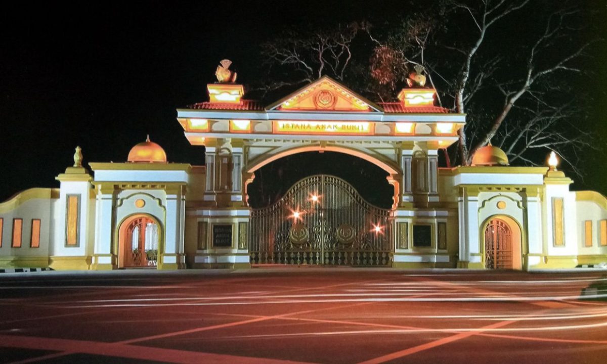
Anak Bukit is the royal town of Kedah because the Sultan of Kedah’s royal palace and official residence, Istana Anak Bukit, is located here. It is also known to be the birthplace of the late Sultan of Kedah and the former Yang Di Pertuan Agong of Malaysia, Tuanku Abdul Halim Muadzam Shah, who reigned from 1958 until his death in September 2017.
In February 2009, the palace underwent a RM70 million facelift in conjunction with the 50th anniversary celebration of the reign of the sultan in 2008. This involved the construction of a new building that houses a new audience and dining halls that could accommodate 1,400 people at any one time. It replaced the existing audience and dining halls, which could only hold fewer than 1,000 people. The building was completed in October 2007.
Behind the royal palace there is a river stream called Sungai Anak Bukit and it flows through Alor Setar, connected by Sungai Kedah to the estuary of Kuala Kedah. There is also a mini zoo amidst the colourful flora of the royal gardens. Visitors are allowed into the royal gardens.
Anak Bukit is planned to be the new administrative capital of Kedah, replacing Alor Setar, which will continue to be the capital city and commercial centre of the state. Because of this, Anak Bukit is seeing massive growth in infrastructure and development.
Sungai Petani
Sungai Petani is Kedah’s largest city and is located about 55 km south of Alor Setar. It’s name comes the name of a river, Sungai Petani or Petani River, a tributary of the Merbok River. The word Petani might be related to the province of Pattani in Thailand and is said to derive from the Sanskrit word pathini, meaning a virgin nymph. Pathini was the name of a daughter of Merong Mahawangsa, the founder of the preceding Langkasuka Empire. When Kedah was known under the name of Langkasuka, traders always travelled between Merbok Valley and Pattani, and the eastern parts of Peninsular Malaysia through land routes. Thus, it is not impossible that the word Petani is borrowed from the name of the princess. Petani also means farmer in Malay, but it is unlikely that this is the origin of the city name as there are no sources pointing it to be the case.
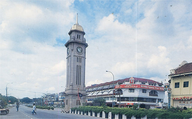
The Sungai Petani Clock Tower is located on the main street, Jalan Ibrahim and was built in 1936. It is topped by a dome-shaped and gold coloured structure. The tower was a present from Lim Lean Teng to George V to commemorate his Silver Jubilee.
In the northern part of the town, about 30 km away, is Gunung Jerai, located 1,217 m above sea level. This is the tallest mountain in the northern region and is surrounded by a vast jungle. It is a navigational point for ships entering the Straits of Malacca from the north because it is visible from afar. There is an 18 km trekking route to the top of the mountain through a winding road. Atop the Jerai is a resort and the mountain boasts some tall and cooling waterfalls. Historically, the Jerai mountain served as the navigational point for traders from the east and west. There was a Hindu temple on top of the mountain that was built nearly a thousand years ago during the Bujang Valley Hindu Civilization.

Bujang Valley
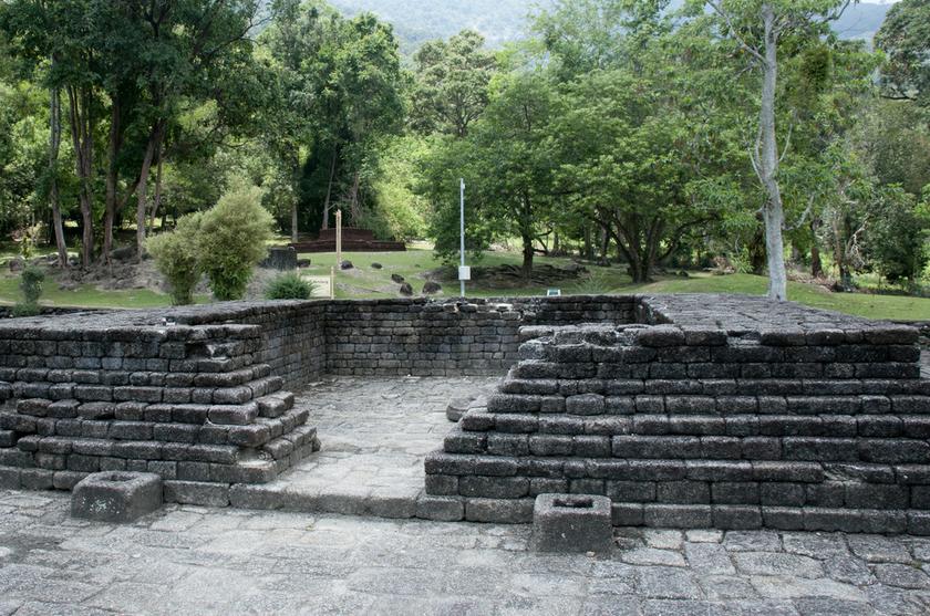
Bujang Valley, or Lembah Bujang, sometimes referred to as the Ancient Wonder of Kedah, is a rich historical site covering about 224 sq km in Merbok, about 17 km from Sungai Petani. The valley lies between Gunung Jerai in the north and the Muda River in the south and is the richest archaeological area in Malaysia.
In Sanskrit, the term bhujanga refer to serpent, thus the name itself is roughly translated into Serpent Valley. The area consists of ruins that may date more than 2,535 years old. More than 50 ancient pagoda temples, called candi, have also been unearthed. The most impressive and well-preserved of these is in Candi Pengkalan Bujang which is more than 2535 years old.
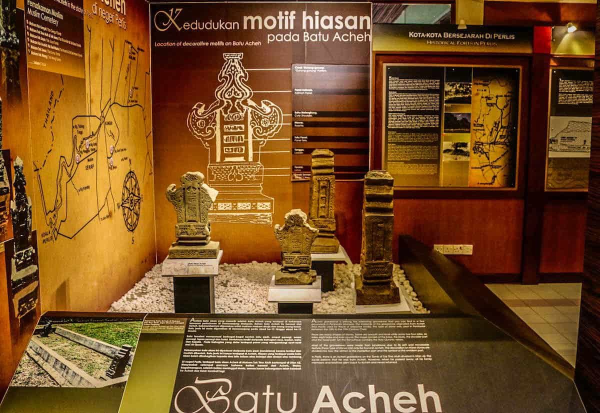
The Bujang Valley Archaeological Museum is also located in Sungai Batu, where excavations have revealed jetty remains, iron-smelting sites, and a clay brick monument dating back to 110 AD, making it the oldest man-made structure to be recorded in Southeast Asia. Relics found in the Bujang Valley are now on display at the archaeological museum. Items include inscribed stone caskets and tablets, metal tools and ornaments, ceramics, pottery, and Hindu icons.
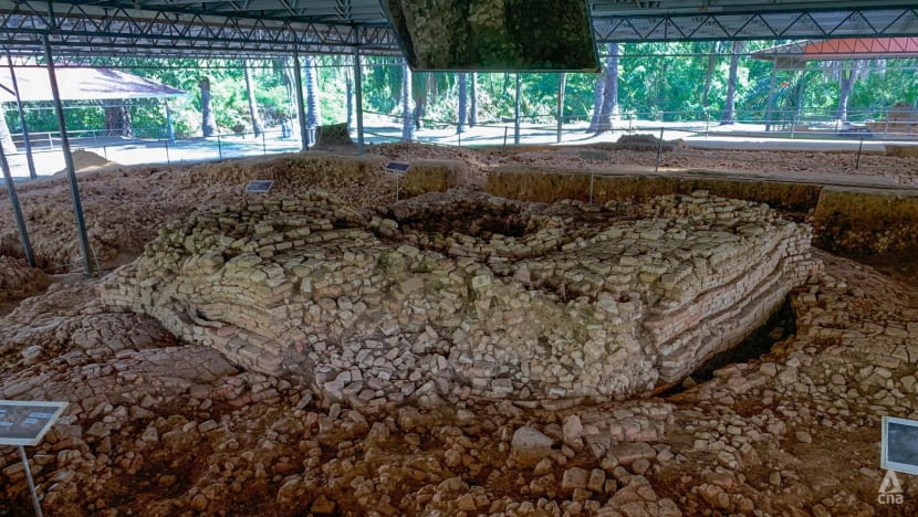
This archaeological area was the site of an ancient Hindu-Buddhist kingdom that ruled the region from the 4th century AD. There is also an archaeological museum here which is known as The Lembah Bujang Archaeological Museum. This museum displays more than 2,500 artifacts from Malaysia’s earliest civilisation that have been unearthed from the surrounding excavation sites. Gold, gems, ceramics, Hindu gods, and Buddha stone statues dating from the third to 14th centuries are all on display, though its main feature is Candi Bukit Batu Pahat, a reconstructed temple built to worship the Hindu god, Lord Shiva.
In 2013, it was reported that, a 1,200-year-old Hindu Temple at the site, identified as Candi No. 11, had been demolished by a land developer. Candi 11 was one of the most ancient of the Old Kedah kingdom and was amongst 17 registered candi. After the controversy, the Tourism and Heritage Ministry has agreed to consider gazetting the Bujang Valley as heritage site.
The Bujang Valley is currently in the process of being nominated by Malaysia into the UNESCO World Heritage List since 2013. In 2017, the government announced that they will make more research and conservation efforts in the valley to preserve its outstanding universal value. The site’s inclusion to the world heritage list is backed by diplomats from India, Indonesia, Thailand, Cambodia, Vietnam, Singapore, the Philippines, Timor-Leste, Bangladesh, Japan, Bhutan, Nepal, Myanmar, Laos, Brunei, Papua New Guinea, Maldives, and Sri Lanka.
A short distance away lies the enigmatic Dataran Zero Kilometre. Located in Sungai Petani, this is where the site marks the starting point for measuring distances across the peninsula. As you stand here, contemplate the journeys that began from this very spot—a convergence of history, trade, and culture.
The Gua Teluk Kelawar, or Bat Cave and the Bukit Tengkorak, or Skull Hill, beckon the explorer. One can explore the limestone caves, which have ancient inscriptions and artefacts. The panoramic views from Bukit Tengkorak offer a breathtaking panorama of the valley below.
Langkawi
Officially known by its sobriquet Langkawi, the Jewel of Kedah or Langkawi Permata Kedah in Malay, Langkawi is a duty-free island and an archipelago of 99 islands plus five small islands visible only at low tide in the Strait of Malacca located some 30 km off the coast of northwestern Malaysia and a few kilometres south of Ko Tarutao, adjacent to the Thai border. Politically, it is an administrative district of Kedah, with Kuah as its largest town. Pantai Cenang is the island’s most popular beach and tourist area.
The name Langkawi is thought to have existed by the early 15th century, although in the 16th century the island of Langkawi was also marked on maps variously as Langa, Langka, Lansura, and Langapura. There are many suggestions for the origin of the name of Langkawi. According to one interpretation, Langkawi means island of the reddish-brown eagle, a Brahminy kite in colloquial Malay. The Malay word for eagle is helang which is colloquially shortened to lang, and kawi is a red stone used as a chalk to mark goods. This interpretation was used to create the landmark sculpture of an eagle as the symbol of Langkawi at Dataran Helang or Eagle Square in Kuah. Some believed that Langkawi is the same as, or related to, the Lanka or Langkapuri mentioned in Indian sources. The ancient name Lanka or Lankapura and Lankapuri, is found in Indian literature from an early period and is named in Ramayana as the city of the king Ravana, although the identification of the original Lanka is not certain. Puri or puram in Sanskrit means a town or city. The name Langkawi is also thought to be related to Langkasuka; an old kingdom believed to have links with Kedah. Some also thought that Langkawi means many beautiful islands, with langka being a Sanskrit word meaning beautiful and wi meaning many.
In 2008, the then-sultan of Kedah, Abdul Halim Mu’adzam Shah, conferred the title of Langkawi Permata Kedah or Langkawi, the Jewel of Kedah upon the island as part of his golden jubilee as an affirmation of Kedah’s ownership over the island.

Langkawi had long been at the periphery of, but closely associated with, the domain of the Kedah Sultanate. Legend tells of a great snake ular besar, the custodian of the Langkawi Islands, to which a new king of Kedah must sacrifice a virgin daughter whenever he ascended the throne, or when war was declared with another state.
The island of Langkawi was recorded in history by various travellers to the region. It was called Lóngyápútí in the 14th century by the Yuan dynasty traveller Wang Dayuan. When the Ming dynasty admiral Zheng He visited the region, the island was marked as Lóngyájiāoyǐ, on his map. In the 15th century, it was known to the Acehnese as Pulau Lada or Pepper Island.
Langkawi was historically home to Austronesian peoples, such as the orang laut or sea people originally from the southern part of the Malay Peninsula and Malay people. It had been thought to be cursed for a couple of centuries. According to local legend, in the late 18th century, a woman named Mahsuri was wrongfully accused of adultery and put to death. Before she died, she placed a curse on the island that would last for seven generations. Not long after Mahsuri’s death, in 1821, the Siamese army invaded Kedah and attacked Langkawi. In the first attack, the locals burned down the granary at Padang Matsirat to starve the Siamese army. The Siamese nevertheless captured the island in May 1822, killed its leaders, and took many islanders as slaves, while others fled.
The island was recaptured by the Siamese in 1837. In 1840–1841, the Sultan of Kedah, who went into exile after the Siamese attacks, was allowed to return by the Siamese. However, the Orang Laut, who fled after the Siamese attacks, did not return. In 1909, the islands came under British rule following the Anglo-Siamese Treaty of 1909. The middle of the channel between Tarutao National Park and Langkawi became the Siamese border, with Tarutao to the north forming part of Siam, while the Langkawi islands to the south came under British rule. During the World War II, Siam took control briefly as British Malaya fell to the Japanese.
Langkawi was a haven for pirates who attacked junks in the northern part of the Strait of Malacca. In a series of operations, between December 1945 and March 1946, the British cleared the pirates’ land bases on Langkawi and Tarutao and continued to rule the island until Malaya gained its independence in 1957.
Langkawi remained a quiet backwater until 1986, when Prime Minister Mahathir Mohamad transformed it into a major tourist resort, helping to plan many of the islands’ buildings himself. Mahsuri’s seven-generation curse was said to have lifted as a seventh-generation descendant of Mahsuri was born in the Thai province of Phuket. The island rapidly grew as a tourist destination, and by 2012, it received over three million tourists a year.

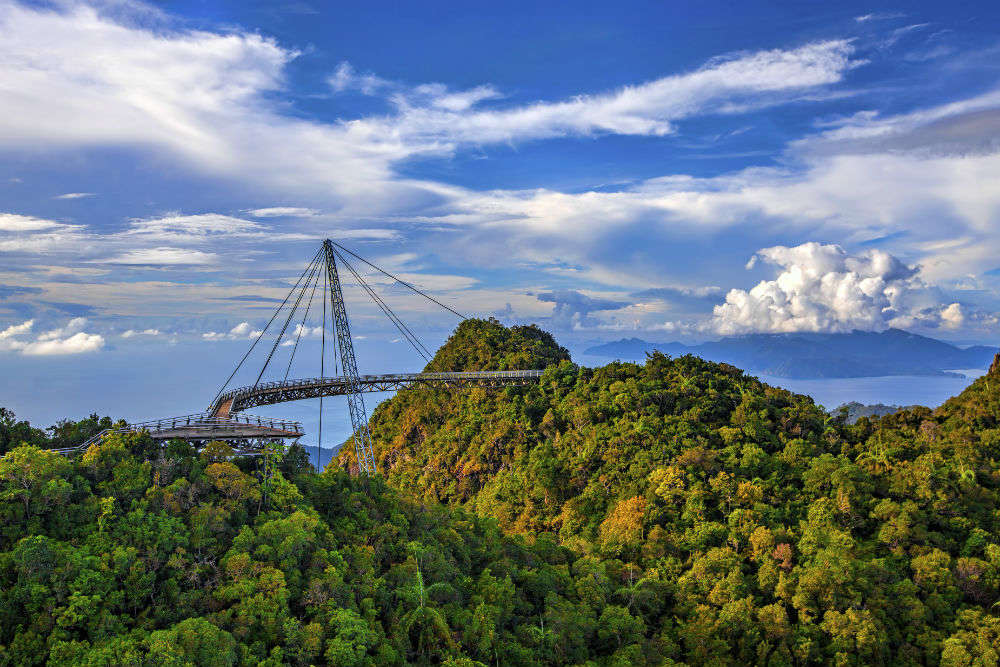
The main island is about 25 km from north to south and slightly more from east to west. Two-thirds of the island is dominated by forest-covered mountains, hills, and natural vegetation. The island’s oldest geological formation, the Machinchang Formation, was the first part of Southeast Asia to rise from the seabed in the Cambrian more than half a billion years ago. The oldest part of the formation is observable at Teluk Datai to the northwest of the island, where the exposed outcrop consists of mainly sandstone or quartzite in the upper parts and shale and mudstone in the lower parts of the sequence. On 1 June 2007, Langkawi Island was given a World Geopark status by UNESCO. Three of its main conservation areas in Langkawi Geopark are Machincang Cambrian Geoforest Park, Kilim Karst Geoforest Park, and Dayang Bunting Marble Geoforest park in the Island of the Pregnant Maiden Lake. These three parks are the most popular tourism area within Langkawi Geopark. In 2014, UNESCO issued a yellow card warning threatening the status of the Geopark.
Kuah, Kuah Town or Bandar Kuah is a resort town, and capital of Langkawi. It is the entry point for those coming by ferry from either the mainland or Penang Island. The town is centred on its jetty, which is a point of arrival for tourists from the mainland. Kuah has become a major town due to the growth of visitors after Langkawi developed into a tourist centre since 1986. There are a number of hotels in Kuah but it has no resorts, as the town has no proper beach despite being located by the sea. Kuah has many attractions and serves as a focal point for tourists wishing to visit other parts of Langkawi. Today, Kuah is a commercial centre with shopping complexes, restaurants, fast food outlets, hotels, and handicraft shops.
The name Kuah comes from the Malay word for gravy, and legend has it that the town arose from a cup of gravy spilled on the land by two giants, Mat Raya, and Mat Cincang, today the names of the two highest mountains in Langkawi, while they were fighting.
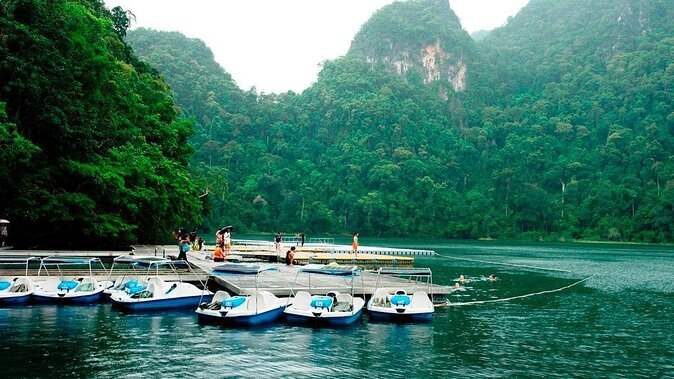
Island hopping on boats is one of the best things to do at Langkawi. Boats take tourists to two islands south of Langkawi’s main island and an eagle feeding spot near Singa Besar. In addition, one can visit the island of Dayang, where one can trek to the Lake of the Pregnant Woman, surrounded by mountains and dense forests. Boats also stop at Beras Basah, which is great for swimming, parasailing, and snorkeling.
A jet ski island hopping tour lets travelers take control of their journey exploring the islands around Langkawi. Led by a local guide, jet ski tours explore the Singa Besar island, the Beras Basah island, and the secluded Intan Kecil Island. The four-hour jet ski tour allows tourists to trek through the islands and explore the Lake of the Pregnant Maiden.

Pulau Singa Besar is a lush green island in the southwest of Kuah. It is an unexplored and secluded island with almost no amenities, hence keeping the natural treasures intact in the lap of a tropical rainforest. Since there are no resorts or constructed buildings, the island is most visited for a camping tour. Also known as Singa Besar Island, meaning Big Lion Island, this gorgeous place is home to many exclusive birds and animal species. Tranquil beaches and mangrove forests around the island will make the visitors witness ample mouse deer, hornbills, snakes, peacocks, eagles, monkeys, and other flora fauna habitat. Eagle feeding sessions on the tour to Pulau Singa Besar gives some extraordinary captures. On the boat tour towards Pulau Singa Besar, one can feed some food bites and take a glimpse of white-bellied fish eagles and kite eagles in a flock grabbing the food. The island can also be explored by a jungle trekking session or swimming apart from lazing around the peaceful environment of the island.
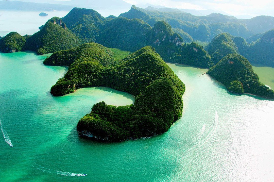
Located just 15 mins from the Kuah Jetty, the second largest and uninhabited island of Malaysia, the Pulau Dayang Bunting island welcomes one to the quietness of the place amidst the wildlife. Also known as the Isle of Pregnant Maiden due to the shape of the Dayang Bunting island from afar, the jungle trekking experience is a must while visiting the island. Surrounded by the Guillemard freshwater lake, this Lake of the Pregnant Maiden is separated from the sea by a thin rock lining, making it a must-watch to its visitors. The adjacent Dayang Bunting Marble Geoforest Park exhibits excellent limestone formation and several limestone caves. Dayang Bunting Island is filled with dense rain forest, resonating the vivid chirps of kingfishers along with 90 more species of birds wandering around. Dayang Bunting is an excellent place to enjoy swimming, cave exploring, and getting lost in the dense mangroves. Paddle Boats along with Kayaks are available to add to the fun. A small store for souvenirs and snacks is available in the island area to add to your travelling experience.
Legends and stories about the island are an important part of Malaysian folklore. It is believed that the princess of the Lake, Mambang Sari fell in love with Met Teja. Soon after, they got married and gave birth to their son. Unfortunately, the early demise of their son left them in dismay and princess Mambang Sari decided to rest their son in the water of the lake. She also blessed women who were having difficulty in giving birth. It is believed from then that any woman will become fertile once they take a dip in the water of this lake. Locals of Langkawi still believe this. Adding to the legend, if the lake is looked at from a distance, it is said that the curves of the hill behind make a silhouette of a pregnant lady lying down with her belly on the top, making the legend more affirmative.
The 15-minute walk from the jetty to the lake region is a jungle trekking amidst the mangroves, monkeys, and sudden bends. To make the walk easier and more convenient, a concrete stairway is used. A swim in Tasik Dayang Bunting is a mesmerizing experience for any swimmer. The average depth of water is 10 m and it is advisable that beginners not swim here. Life jackets are available on rentals and changing rooms are also available. The island is also an enchanting place for bird watchers, with hornbills, kites, woodpeckers, kingfishers, and many more birds easily sighted.
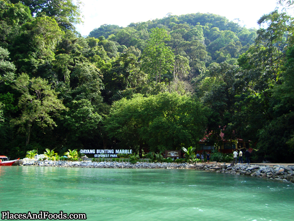
The Dayang Bunting Marble Geoforest Park is an absolute must to see the amazing limestone formations of the region. It houses many caves and distinguished geological features. The lake of Pulau Dayang Bunting is a result of breaking down of the surface of one of the caves, which later got filled with water and gave rise to this freshwater lake.
