
Panauti
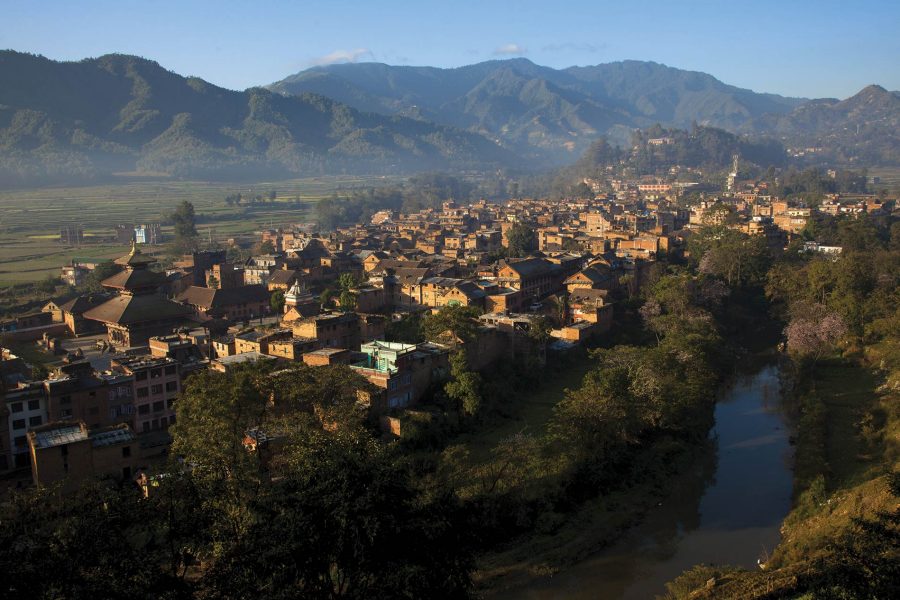
Listed as a UNESCO tentative site since 1996, Panauti lies 33 km southeast of Kathmandu and is a leftover reminiscence of a time long bygone. The word ‘Panauti in Hindi means unlucky, and for some unknown reason, it sits perfectly well with the historical background of this medieval city. At one glance, the town of Panauti is a melancholic chock-a-block of wooden houses, public halls, temples and shops, all nestled together resembling the shape of a fish in the laps of Himalayan greenery. Though still dotted with enough places worth mentioning, there is a feeling of decay spread all across the once prosperous town.
On the north-east of the town lies the peak of Goraknath Hill at 2000 ft, from where a breathtaking panoramic view of the town can be seen. There are occasional courtyards or public squares as well, but one will not see a throng of tourists loitering around in this town.
Panauti was originally a small state given by King Bhupatindra Malla as dowry to his sister. The town has a population of under 15,000 people and a few prominent sites, such as the Indreswor temple and Panauti or Layaku Durbar square found in the town centre. At the end of the 13th century, Panauti was integrated into the unified kingdom of Nepal, along with Kathmandu, Patan, and Bhaktapur, all former capital cities of the Kathmandu valley. Panauti was a trading hub along the ancient Salt Trade route between Tibet and India. The recorded history of Panauti goes back to the first century AD. However, with the end of the Salt trade in the 1950s and the construction of the Arniko Highway in the 1960s bypassing the town, Panauti went into an economic rut. Panauti, consists of a variety of Buddhist and Hindu religious monuments, and is considered to be one of the area’s most important medieval sites. Panauti is also steeped in culture and tradition. Visitors will often find colorful stones, petals and other items that are laid out on the pavement to welcome everyone with great hospitality.

Panauti, situated at the confluence of the two rivers Rosi and Punyamati, has been regarded as an important religious site since very early times. In Nepali society, such rivers are considered to be sacred. A visit or just an ablution to such places enables the visitor to be freed from many sins and anxieties, as it is believed to be sacred. It is also believed that at Panauti, in addition to the two rivers, a third river Lilawati also converges making it again a tri-junction called Triveni. However, the last one is said to be visible only to the seers and intellectuals. On account of this, during every festival, a great number of devotees from all across the country pour here for a holy ablution and to pay homage to the nearby Indreshwor Mahadev Temple and other holy sites located here. The site is also regarded as Prayagtirtha of Nepal. It has been debated that Panauti was founded by Ananda Malla (1274-1310AD), others believe that there is a golden scripture dated 1385, which is located within the Indreshwar temple stating that King Harisingh Dev founded the town. Although Panauti was founded independently, as time went under the influence of Bhaktapur, increased and later it became part of Bhaktapur up until the 18th century. In 1763, King Prithvi Narayan Shah annexed Panauti to the larger and greater Nepal.
The main ethnic culture of Panauti is of the Newaris, which is spread over the bigger cities of Bhaktapur, Patan and Kathmandu. Their traditions and centuries old, and one of the most popular ones is the masked dance in devotion to multiple gods and goddesses. The earliest one is the Harisiddhi dance, done for the goddess Shakti. Another one is Nava Durga dance, whose preparations begin as early as June, by burning the old masks and throwing them into the holy river. These dances are part of the age-old culture of Panauti and are performed religiously, amidst a crowd of interested onlookers, in the Durbar Square of the town and other parts of the Kathmandu Valley area as well.
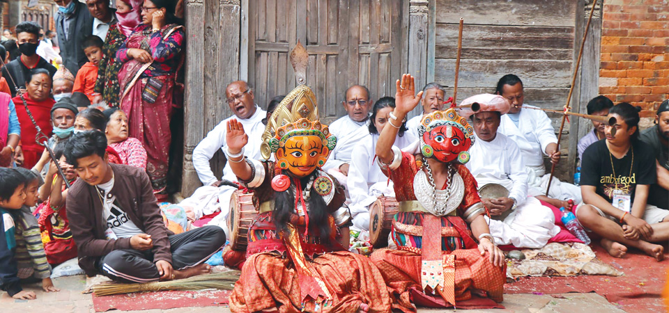
The Harisiddhi dance is considered to be the oldest traditional dance in Nepal. This dance was initiated about 2,400 years ago by King Vikramaditya. It is said to use the language of gods and speech of the spirits. As a result of discontinuity, it disappeared, and King Amar Malla was the first to re-initiate the dance. However, the tradition again vanished and was finally revived by King Pratap Malla. It was said that Raja Vikramaditya went to Ujjain, and brought the image of three Shaktis, or attributes, named Harisiddhi, placed her near Nil Tara from this, and this is how the village of Harisiddhi originated. The Raja then under the direction of the Goddess brought all the gods Nepal to that place with great ceremonies and dramatic and vocal instrumental music. It is well known that there is no dramatic performances to that of Harisiddhi.
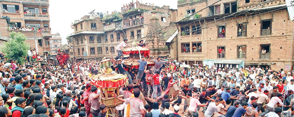
Panauti Jatra is known as the chariot festival, which takes place every year in Panauti, at the end of the monsoon. The Jatra festival usually begins on the tenth day of the bright fortnight during the month of Jestha, in May or June. The Jatra is usually celebrated for three days, as everyone becomes busy for the preparation of celebrating the festival, known as Duin-chha-nya-ye-ke-guis, which is usually held in the evening. This event is one of the major cultural attractions of the Panauti Jatra. During this festival, images of the gods from the town’s temples are placed in a chariot and displayed around the city. The pulling of the chariot begins from the town’s old Durbar Square. A team consisting of a priest, a woman, and a porter crosses the bridge over the Punyamati River to worship the gods. This crossing over the Punyamati River is a yearly event and signifies the tradition from many years before. The following day of festival is called Mu-jatra, which means the main festival. On this day, many of the residents of Panauti will sacrifice male goats or ducks to the Gods, and many other will simply make an offering of food. The sixth day is the full moon day, which is also known as Panauti Punhi. This day is the most favorable day for visiting the river and cleaning your body.
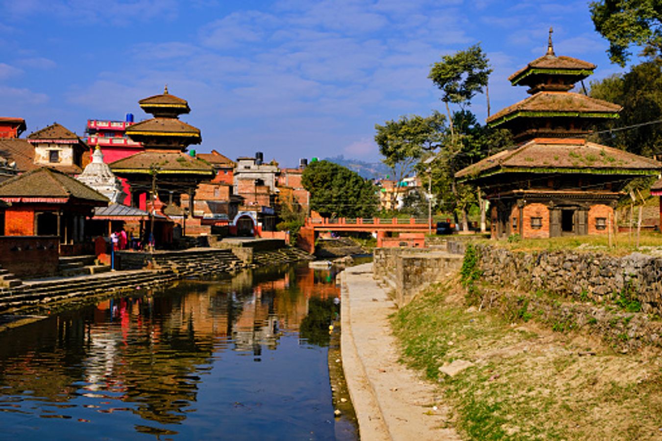
Panauti is situated at the confluence of two main rivers, Rosi and Punyamati which has been regarded as an important religious site. In Nepali society, it is also believed that rivers are sacred places and such a visit allows man to cleanse his body and be freed from sins and anxieties. It is believed that there is also a third invisible river, the Lilawati creating a tri-junction and is historically known to have remarkably enhanced Nepal’s religious sanctity and popularity especially in Panuati. Due to the convergence of these three rivers, on festive occasions, large numbers of people from around the world come to this holy place to pay their respects, as well as visiting the Indreswor temple and other holy sites located in Panuati. The confluence of these three rivers is an important pilgrimage site where every 12 years, a month-long fair is held known as the Makar Mela. During this celebration, hundred and thousands of devotees visit Panauti to cleanse themselves in this sacred water.
The Namobuddha festival is a revered Buddhist festival, also celebrated with equal fervour by the Hindus, commemorates the great Prince Mahasatwo, who was born in Panauti and sacrificed his mortal body to feed a starving tiger and her little cubs. The festival is held city-wide, but mainly at the Namobuddha Monastery in the fringes of Panauti.
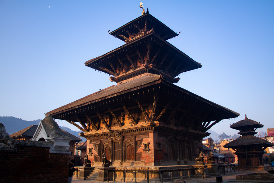
The Indreshwar Mahadev Temple is one of the largest and tallest pagoda style temples in Nepal. It was originally built over a lingam in 1294, making it the oldest surviving temple of Nepal. The roof struts embellishing the two lower stories of the temple are distinct Nepalese woodcarving and architecture. The upper section of the temple is hung with pots and pans, offerings from young married couples hoping for a happy and prosperous family life. The temple is in good condition and survived the 2015 earthquake. It is from this temple that the mystical third river of Panauti starts from leading to the Brahmayani temple across from the Tri Beni Ghats. The Indreshwar temple is kept in a very well maintained, walled in, compound which is managed by the Panauti Museum.
The non-existent, invisible part of this trident, the Lilawati River, is said to have originated from the Indreshwar Temple, located in Durbar Square. While the bottom two floors are adorned with intricate wood carvings, native to any Nepalese shrine, the top floor has endless bunches of hanging pots and pans – offerings from newly-wed couples hoping for a happy and everlasting marriage. Dedicated to Lord Shiva, the temple reflects the true essence of Newari culture and architecture in its three wooden storeys. Newars are the original descendants of the mountainous country, and their ancestors are said to have been there since civilisation started in the Kathmandu Valley.

Holding a close resemblance to the Buddhist Pagoda, but worshipping a Hindu god in its shrine, the age-old temple is a perfect embodiment of what the culture of Nepal looks like. Though scholars have dated the Indreshwar Temple back to the very late 13th century, it still stands tall and magnificent and is perhaps the most popular site in Panauti.
Other than the shrine itself, there is also a museum, a king’s palace and some other excavated brick and mortar structures scattered all across the Durbar Square, and there are some more still hidden under the earth somewhere, waiting to be dug out and explored. There is an entry fee of INR 300 for the entire place.
Other than this temple, there is also the king’s palace in Panauti’s Durbar Square, which has yet to be excavated to a larger extent in order to reveal more about Panauti. Nevertheless, there are many artifacts and remnants such as stone taps, bricks, water wells and coins found among some of the excavated sections of the palace.
The trekking route from Panauti to the colourful fluttering flags of Namo Buddha can be a charming addition to a Panauti trip. Located at 1750 metres above mean sea level, the uphill walk to the monastery takes not more than 45 minutes to one hour, depending on the speed and how many times one stops. Hikers get to see vast expanses of lush green paddy if they are travelling just before the harvest season otherwise, the sights one sees is that of farmers toiling in the fields.

Daman
One of Nepal’s most beautiful tourist destinations, Daman lies on the Tribhuvan Highway, about 77 km southwest of Kathmandu, about halfway to Hetauda, at an elevation of 2,322 m. The town has some of the greatest views of the Himalayas, extending on a good day from Dhaulagiri in the west to Mount Everest in the east. Daman also has the Everest Panorama Resort, which includes a helipad. During winter, snowfall occurs in the hills, augmenting the beauty of the place. The Risheshor Mahadev Temple is where it is said was where Lord Shiva rested when he was mourning and lamenting, carrying dead body of his beloved wife Satidevi. Being so thirsty he just hit the big rock with his weapon, the trisula, and water came out. Even today, one can see the water flowing in between the big rocks. The main festival occurs in Fagu Purnima and Thulo Ekadashi. There is a beautiful botanical garden in Daman which is one of the biggest and oldest botanical garden in Nepal. Different varieties of Rhododendron are available here.
With many picnic spots for outings, Daman can be visited just as a one-day trip or one can stay a few days. More than 90% of the people living in Daman are dependent on agriculture and rest of them on hotel business and other. Every season has its own appeal in Daman. The springs have red rhododendrons spread all-over the mountains and in the botanical gardens as well. Autumns bring in the clearest sky of the year and perfect view of the mountains. Summers are pleasantly warm and ideal for all the hiking and biking trails. Winters in Daman are quite magical, with bone-chilling cold and snowfall – a perfect setting for Christmas. Daman is often seen as a weekend getaway with the town especially during major festivities like Diwali and Christmas. The best thing to do in Daman is to explore the town. There are multiple hiking routes, and one can find newer routes.

For the lovers of everything green, the Mountain Botanical Gardens is a must-visit place in Daman. The lawn of the garden is very well-curated and beautifully maintained. The forested area has a great collection of flora – one that you do not possibly expect in a place so secluded. During springtime, the botanical gardens get decked up in ravishing red blooms of the rhododendron – Himalaya’s most exotic blossom.

The Shree Rikheshwar Mahadev Temple is a shrine situated atop Daman, dedicated to the Hindu God of Destruction, Lord Shiva. The local people consider this temple to be very sacred and awakened, which means their wishes get granted once it is spoken to the lingam here. A common practice in Shivalinga temples is to whisper the prayers and wishes into the ear of the Nandi bull that sits guarding the sanctum. The road leading up to the Rikheshwar Mahadev Temple is even more interesting. Visitors need to hike for a short distance of 1 km on a trail covered with dense green woods.
Pokahra
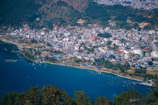
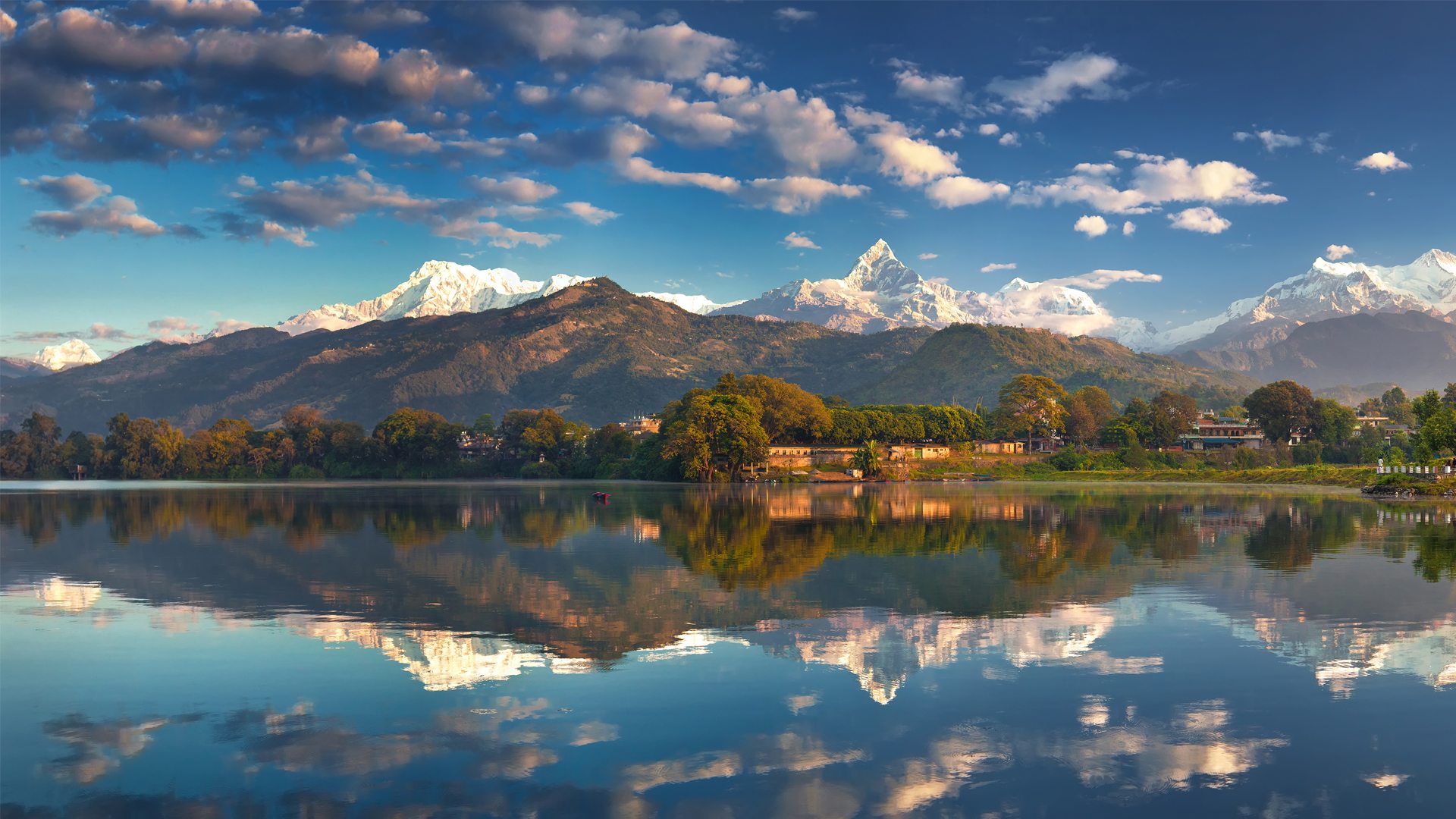
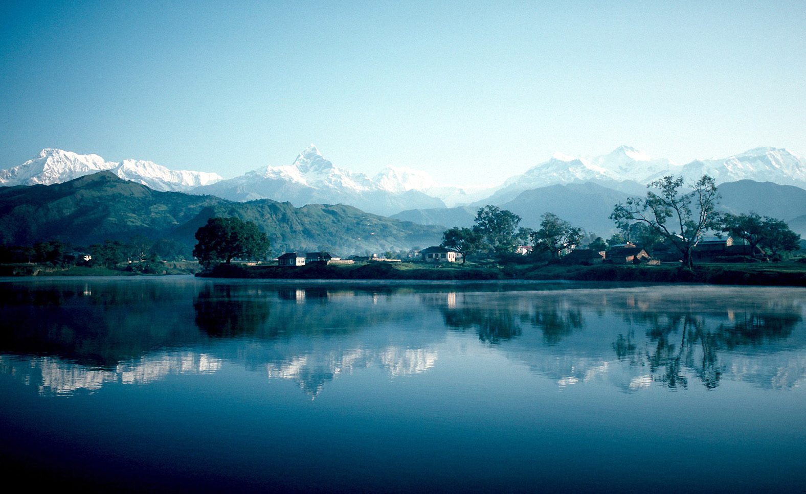
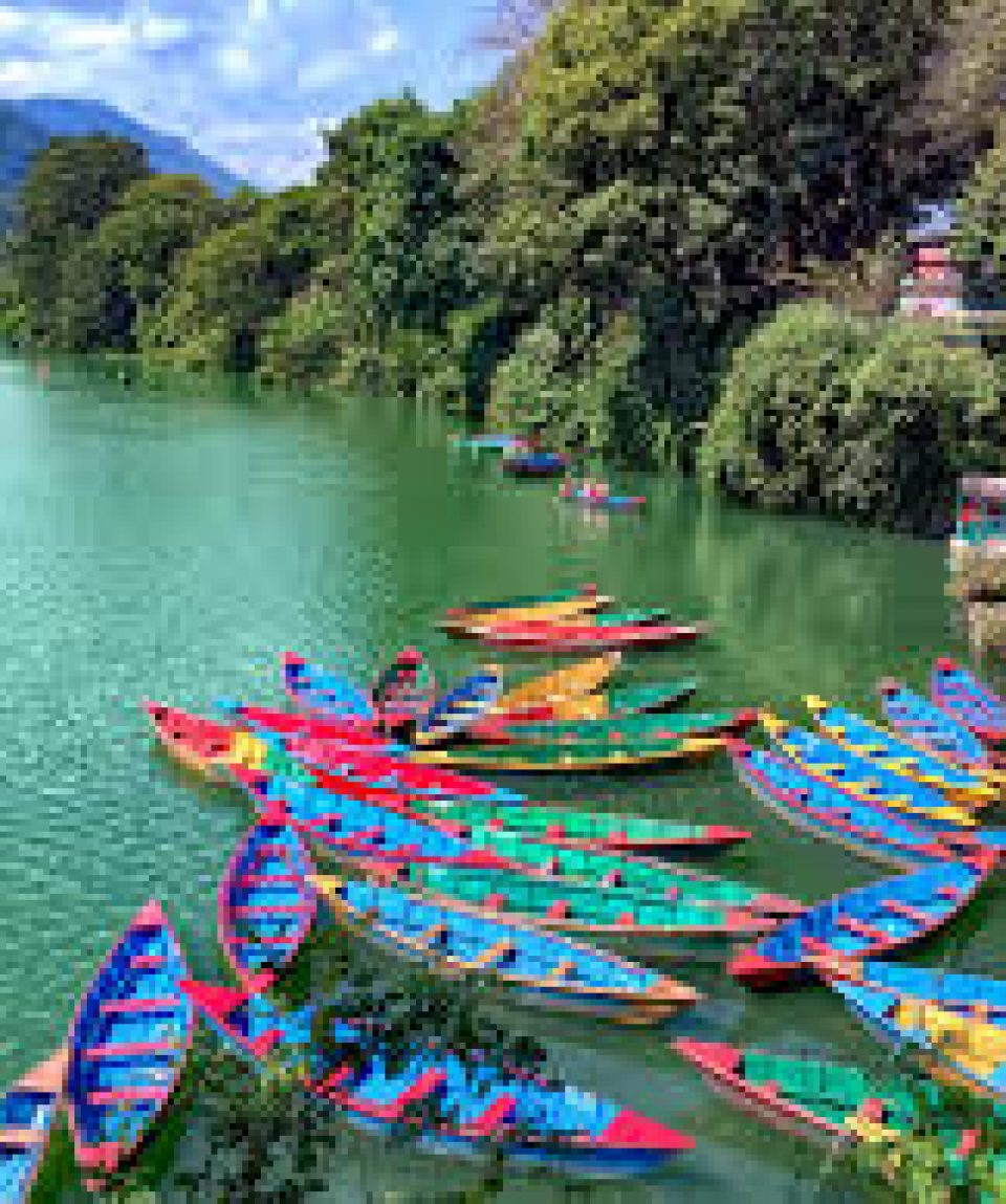
Located in central Nepal, Pokhara serves as the capital of the Gandaki province and is known as Nepal’s tourism capital. It is the second most populous city after Kathmandu and the country’s largest metropolitan city in terms of area. The city also serves as the headquarters of the Kaski district. Pokhara is located 200 km west of Kathmandu on the shore of Lake Phewa, and sits at an average elevation of approximately 822 m above sea level. The Annapurna Range, with three out of the ten highest peaks in the world: Dhaulagiri, Annapurna I, and Manaslu, is within 24–56 km aerial range from the valley. In 2024, Pokhara was declared as the tourism capital of Nepal, being a base for trekkers undertaking the Annapurna Circuit through the Annapurna Conservation Area region of the Annapurna ranges in the Himalayas. The city is also home to many of the elite Gurkha soldiers. The Nepali word Pokhari means a pond, and Pokhara is a variant of Pokhari as the city has numerous ponds.
Pokhara lies on an important old trading route between China and India. In the 17th century, it was part of the Kingdom of Kaski which was one of the Chaubisi Rajya or 24 kingdoms of Nepal, ruled by a branch of the Shah dynasty. In 1786, Prithvi Narayan Shah, the last ruler of the Gorkha Kingdom and first monarch of the Kingdom of Nepal, added Pokhara to his kingdom.
The first settlement of the valley is theorised to have taken place when the first King of Kaski, Kulamandan Shah Khad, also called Bichitra Khan and Jagati Khan, made Batulechaur in the northern side of the valley his winter capital during the mid 14th century. The people settled here included Parajuli Brahmins, who were asked to look after the Bindhyabasini temple and were given some land in that locality as Birta. Dhobi Gauda was the first market center developed in Pokhara valley before the last King of Kaski brought sixteen families of Newars from Kathmandu to develop the present-day market in the 1770s. Prior to that people were settled in the peripheral hills. Pokhara was envisioned as a commercial centre by the King of Kaski in the mid 18th century when Newars of Bhaktapur migrated to Pokhara, upon being invited by the king, and settled near main business locations such as Bindhyabasini temple, Nalakomukh and Bhairab Tole. Most of Pokhara, at the time, was largely inhabited by Khas, Gurungs, Magars and Thakuris. Today the Khas, Gurung or Tamu and Magar form the dominant community of Pokhara. There is also a sizeable Newari population in the city. Batulechaur in the far north of Pokhara is home to the Gandharvas or Gaaineys who are the tribe of musicians.
From 1959 to 1962, approximately 300,000 exiles entered Nepal from neighboring Tibet following its annexation by China. Most of the Tibetan exiles then sought asylum in Dharamshala and other Tibetan exile communities in India. According to UNHCR, since 1989, approximately 2500 Tibetans cross the border into Nepal each year, many of whom arrive in Pokhara typically as a transit to Tibetan exile communities in India. About 50,000–60,000 Tibetan exiles reside in Nepal, and approximately 20,000 of the exiled Tibetans live in one of the 12 consolidated camps, eight in Kathmandu and four in and around Pokhara.
Until the end of the 1960s, the town was only accessible by foot and it was considered even more a mystical place than Kathmandu. The first road was completed in 1968 after which tourism set in and the city grew rapidly. The area along the Phewa lake, called Lakeside, has developed into one of the major tourism hubs of Nepal.
Due to the high population density and the frequency of natural disasters, western Nepal is considered one of the most disaster-prone regions in the world. Pokhara is considered particularly vulnerable to earthquakes and floods because the Seti Gandaki River flows through the city.
Pokhara lies in the northwestern corner of the Pokhara Valley, which is a widening of the Seti Gandaki valley. In this region, the mountains rise very quickly, and within 30 km, the elevation rises from 1,000 to 7,500 m. As a result of this sharp rise in altitude the area of Pokhara has one of the highest precipitation rates in the country. The Seti Gandaki is the main river flowing through the city with the river and its tributaries creating several gorges and canyons in and around Pokhara that give intriguingly long sections of terrace features to the city and surrounding areas. These long sections of terraces are interrupted by gorges that are hundreds of metres deep. The Seti gorge runs through Pokhara from north to south and then west to east; at places, these gorges are only a few metres wide. In the north and south, the canyons are wider.
In the south, the city borders Phewa Tal or Phewa Lake at an elevation of about 800 m above sea level, while north of Pokhara, the village of Lumle at 1,740 m touches the base of the Annapurna mountain range. Pokhara, the city of lakes, is the second-largest city of Nepal after Kathmandu. Three 8,000-m peaks: Dhaulagiri, Annapurna, and Manaslu, can be seen from the city while the Machhapuchchhre or fishtail with an elevation of 6,993 m is the closest to the city.
Since the 1990s, Pokhara has experienced rapid urbanisation with a result that service-sector industries have increasingly contributed to the local economy overtaking the traditional agriculture. Tourism, service sector and manufacturing contributes approximately 58% to the economy, remittances about 20% and agriculture nearly 16%.
We will be continuing learning more about this amazing city in the next part…

