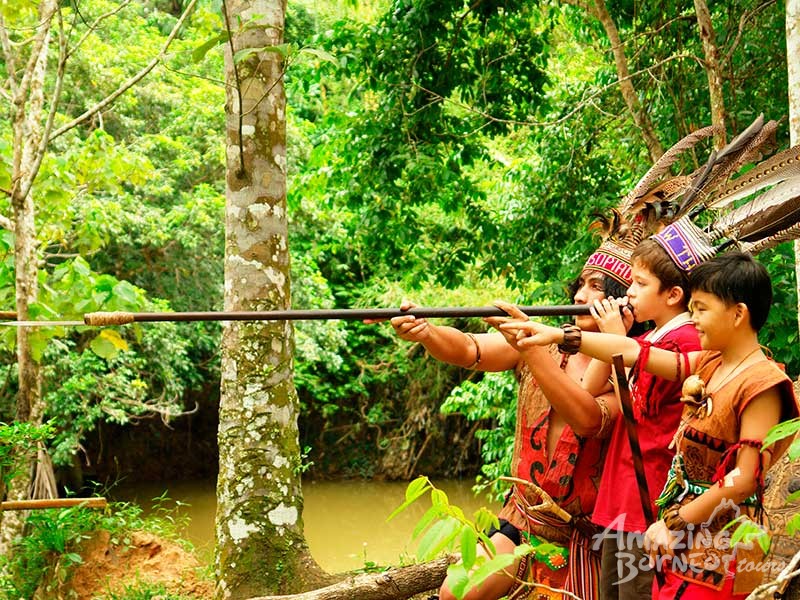
Travel Bucket List: Malaysia Part 56 – Sabah Part 5

Sepilok
Sepilok is a small town located in the state of Sabah, around 25 km from Sandakan, popularly known for its Orangutan Rehabilitation Centre which is a perfect spot for ecotourism and to enjoy a laid-back weekend. It is also known for the World’s only Sun Bear Sanctuary, the Sun Bear Conservation Center. Another major highlight is the Rainforest Discovery Center.

Located about 25 km west of Sandakan, the Sepilok Orangutan Rehabilitation Centre opened in 1964 as the first official orangutan rehabilitation project for rescued orphaned baby orangutans from logging sites, plantations, illegal hunting or being kept as pets. The orphaned orangutans are trained to survive again in the wild and are released as soon as they are ready. The sanctuary is located within the Kabili-Sepilok Forest Reserve which covers an area of 4,294 ha, much of which is virgin rainforest. Today around 60 to 80 orangutans are living free in the reserve. The activities of the centre have been featured in multiple television series. In October 2014 the centre opened a section where visitors can view the nursery area where the younger Orangutans first learn to be outside and play on a large climbing frame. This consists of 2 large indoor seating areas, one with air conditioning and one with fans only, with a large window that overlooks the play area.

The centre allows visitors to feed the orangutans from the feeding platform. However, separate charges apply to those who wish to indulge in this activity. A 20-minute video about the Sepilok Orangutan Rehabilitation Centre is played inside the centre 6 times a day. The videos are played at 9 am, 10:30 am, 11 am and 12 noon.

The centre is open from 9 am to 12 noon and then again from 2 to 4 pm Saturday to Thursday. On Friday, it is open from 9 to 11 am and then between 2 to 4 pm. The ticket counter is open from 9 to 11 am and 2 to 3:30 pm. Entry fees for Malaysians are RM for adults and RM 2 for children while foreigners pay RM 30 for an adult and RM 15 for a child.

The Bornean Sun Bear Conservation Centre is a wildlife conservation and research centre for improving animal welfare and rehabilitation of the Malayan sun bear. It also aims to raise public awareness about the plight of the sun bears and to raise conservation awareness about this species. The BSBCC was established as a non-profit organisation in Sabah in 2008. It is a joint project between sun bear researcher Wong Siew Te, Land Empowerment Animals People (LEAP), the Sabah Wildlife Department (SWD) and the Sabah Forestry Department (SFD). The BSBCC is a neighbour to the Sepilok Orangutan Rehabilitation Centre in Sepilok and shares veterinary facilities, personnel, parking, access roads and ticket gates. The layout of the centre is divided into three parts, with areas prioritised for visitors, bears and staff members. These include the visitor centre, walkways and observation platform, the outdoor habitat of the sun bears and indoor overnight quarters of the bears, and administrative and veterinary facilities.

The Rainforest Discovery Center, RDC is one of the most popular educational centres that houses a variety of flora and fauna. Some of the attractions include the Plant Discovery Garden, the Kapili-Sepilok Forest Reserve, the orchid garden exhibition halls, the paddleboat ride, the lakeside walking trail and canopy towers. This park is also home to about 300 bird species. Guided tours are also available.

Lahad Datu
The town of Lahad Datu is surrounded by stretches of cocoa and palm oil plantations and is an important timber exporting port. A settlement is believed to have existed here in the 15th century, as excavations have unearthed Ming dynasty Chinese ceramics. Just east of Lahad Datu is the village of Tunku, a notorious base for pirates and slave traders in the 19th century.

Based on a Jawi manuscript in the Ida’an language dated 1408 AD, it is believed to be the first site in northern Borneo where Islam was first introduced. The Jawi manuscript gives an account of an Ida’an man named Abdullah in Darvel Bay who embraced Islam.

On 23 September 1985, 15-20 armed foreign pirates from the neighbouring Philippines landed on this town, killing at least 21 people and injuring 11 others. Another standoff occurred in February 2013 and lasted for over a month between Malaysian authorities and the Filipino-based militants of the self-proclaimed Royal Security Forces of the Sultanate of Sulu and North Borneo led by Jamalul Kiram III that resulted in a Malaysian victory and creation of the Eastern Sabah Security Command and Eastern Sabah Security Zone. The standoff reportedly saw a total of 68 deaths – 56 from the Sulu sultanate, nine from the Malaysian authorities and six civilians. Before this incursion, the government of Malaysia continued to dutifully pay an annual cession payment amounting to roughly $1,000 to the indirect heirs of the Sultan honouring an 1878 agreement, where North Borneo – today’s Sabah – was conceded by the late Sultan of Sulu to a British company. After the event, the Malaysian government halted the payment. Years later, eight of these Sulu heirs, who insisted they were not involved in the standoff, hired lawyers to pursue legal action based on the original commercial deal. The case is still ongoing.

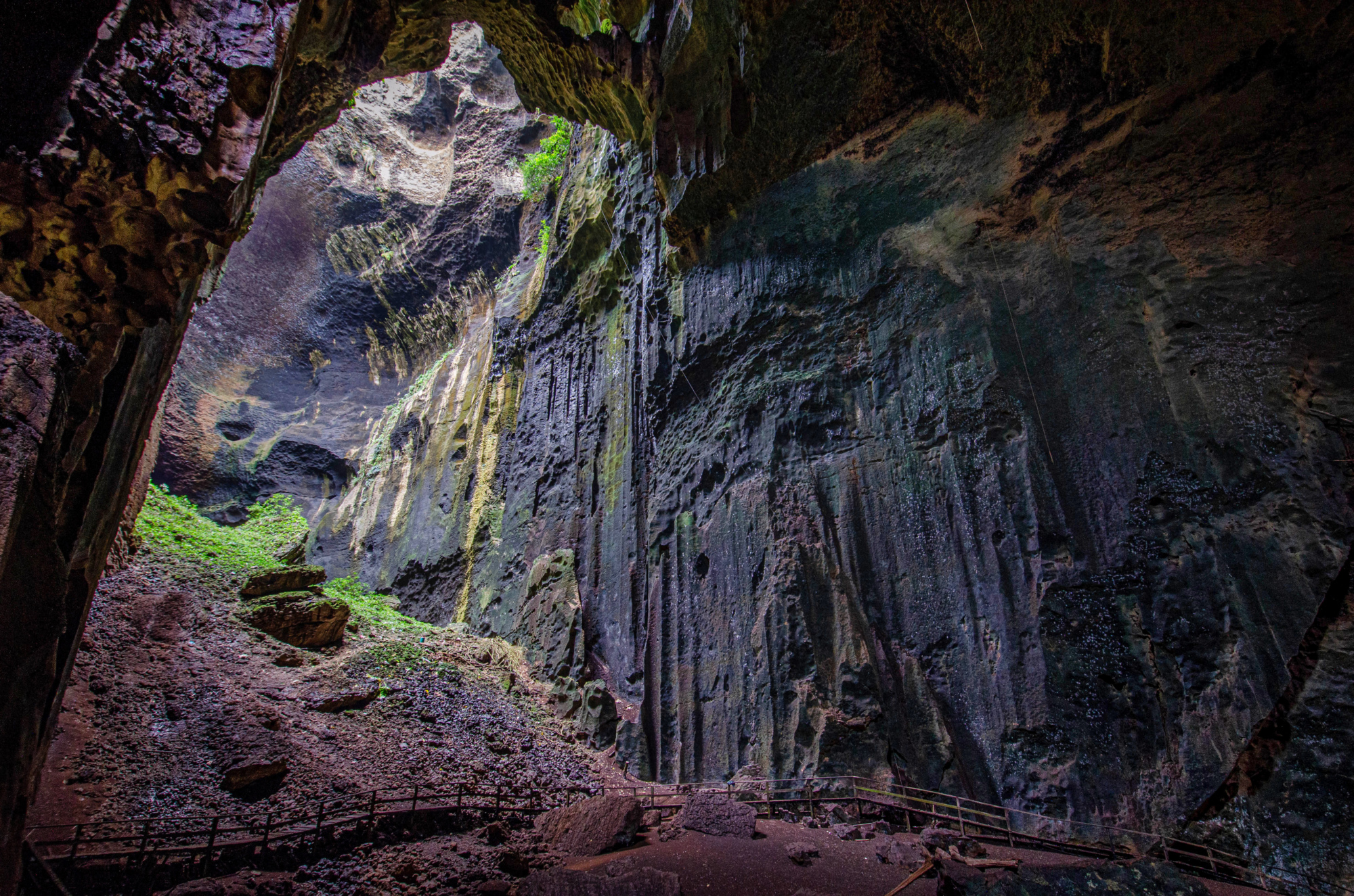
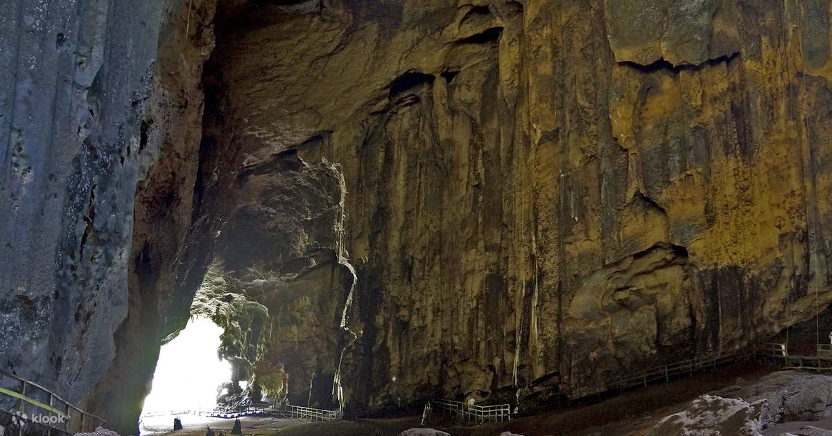
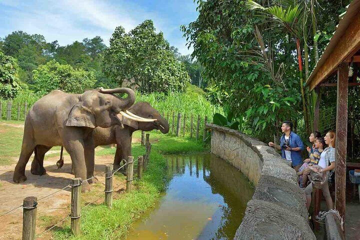
The Tabin Wildlife Reserve is located in a 1,225 km natural preserve located 48 km from Lahad Datu. It is considered the largest wildlife reserve in Malaysia covering an area of 300,000 acres. One major drawing factor of this reserve is its mineral-rich mud volcanoes which spew out mud every day and are the perfect place to spot endemic animals.

The endangered species in the reserve include the Borneo Pygmy elephants and several exotic birds. It also houses several tropical plants which have great medical and therapeutic significance. Several activities like trekking, hiking, birdwatching and night drives are the prime factors for visiting this quiet yet adventurous greenwood.

Being home to more than 300 recorded species of birds, Tabin is a paradise for bird lovers. Two birdwatching tours are arranged – early morning or early evening. The tour is usually for one hour. Some of the rarest species of the birds spotted at the Reserve include the Speckled Piculet, Chestnut-capped Thrush and Thick bellied flowerpecker.

Mud Volcanoes are a unique feature of Tabin Wildlife Reserve. The best time to visit these volcanoes is early in the morning as the volcanoes are visited by animals. A walk to these easily accessible volcanoes in the morning could be worth a sight, especially of the big three animals – the Pygmy Elephant, the Sumatran Rhinoceros and the Tembalu. Visit the Lipid Mud Volcano which is the nearest volcano to Tabin Base Camp. Fresh mud is spewed by the volcano every day and is worth the sight.

Lipad Waterfall, also known as Twin Waterfall is a 1.5-hour trek from Tabin Wildlife Lodge. The trek is easy and simple with several chances to spot wildlife. Enjoy a swim in the pools at the base of the waterfall. Night drivers are also arranged by the lodge every night. It is a perfect opportunity to witness the nocturnal animals. There are nine trekking trails in the Reserve. All these trails require the company of a professional guide.

The reserve is located at the centre of the Dent Peninsula and comprises almost 300,000 hectares, twice the size of Singapore. The national reserve has several endangered species and also houses nine primate species on its premises, including the Orangutan and three endangered cat species. There are also more than 300 species of birds and it is one of the best spots for bird watching in the country.

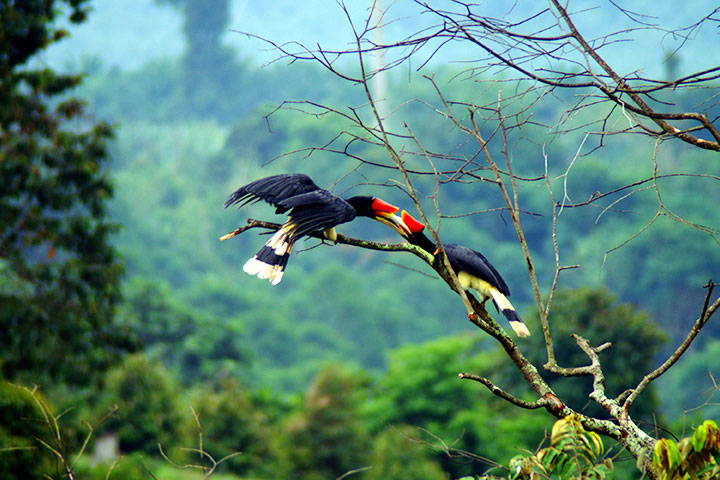
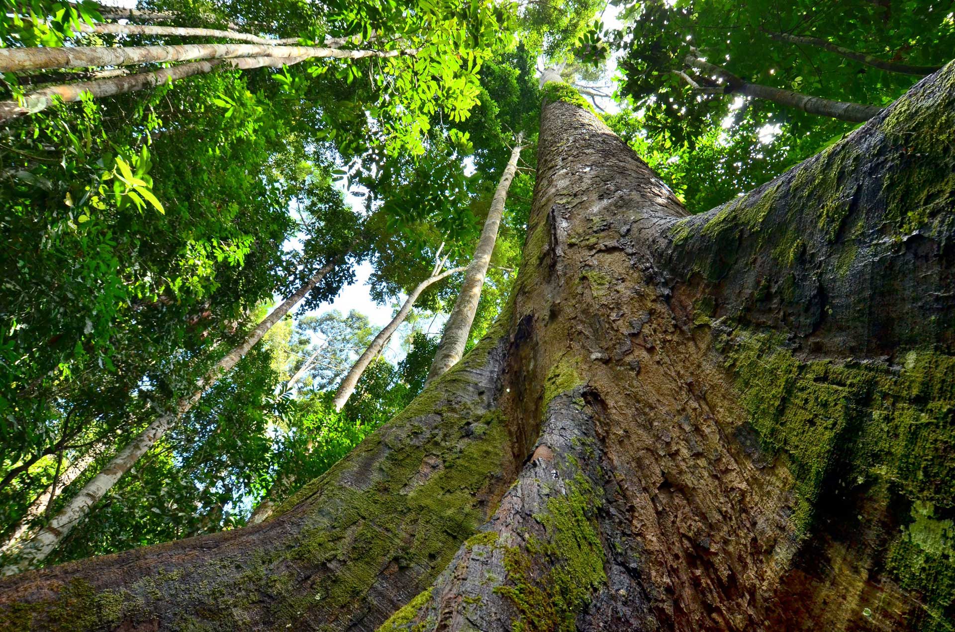
Located in the northeastern part of Borneo, the Danum Valley Conservation Area is a lowland dipterocarp forest. Spreading over 438 sq km, this pristine forest land is around 82 km from Lahad Datu. It houses endemic flora and fauna and is known for species such as gibbons, mousedeer, the Bornean orangutan and over 250 species of birds. Danum Valley is an ideal place for birdwatching, wildlife sightings and an adventurous stay in a forest. The forest has great topography ranging from cascading waterfalls to hills to rivers, thus offering a wide variety of activities like swimming, trekking and hiking. Night Walks and Night Drives are among other thrillful activities to experience at the Conservation Area. The Valley is of great interest to the scientists who have been researching the forest for years. Several research programmes are conducted all year round. The forest is unique as it has never had any permanent human settlement or hunting.

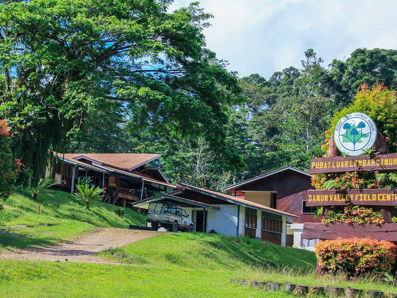
Early morning is the best time for birding as they can be spotted in large numbers. The guide takes the tourists through the trails and roads where other animals like Gibbons, Borneon Britslehead, Blue-headed Pitta and Argus Pheasant can be spotted. 4X4 Night Drives are planned and done by the Danum Valley Field Center. Drives are meant for spotting nocturnal animals like wild cats, civets and flying squirrels. They charge RM 160 and a maximum of 8 people are allowed in the car. BRL also has an extended night drive which starts at 8:30 pm and returns at 1 or 2 am. Charges are extra for the extended rides. Night Walks are a major draw of the forest. This is a guided tour to spot several animals and reptiles. Slow Loris and Western Tarsier are majorly spotted during these night walks. Another major activity offered by the Field Center is a short trip to the Bukit Atur Global Atmospheric Watch, GAW. Being at an elevation, Atur Hills gives a panoramic view of the rainforest and splendid sunrise. Tourists are allowed to swim in the Senggama River. However, the tourists are only allowed to bathe near the river bank by the Field Centre.

Entry fees include the conservation fee of RM 50 per person, and a ranger fee of RM 30 per hour, while the education and nature gallery fee is RM 10 per person. A compact camera fee is RM 10 per camera while a DSLR camera will incur a fee of RM 100 per camera.

Semporna
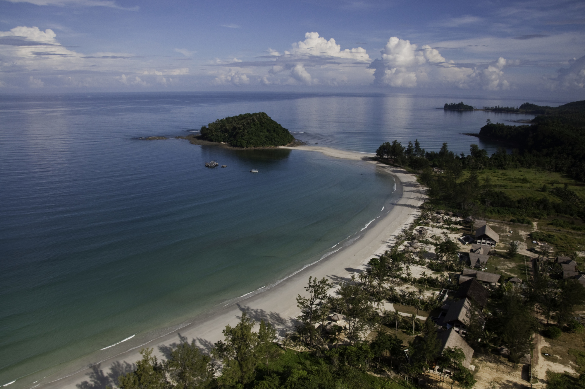
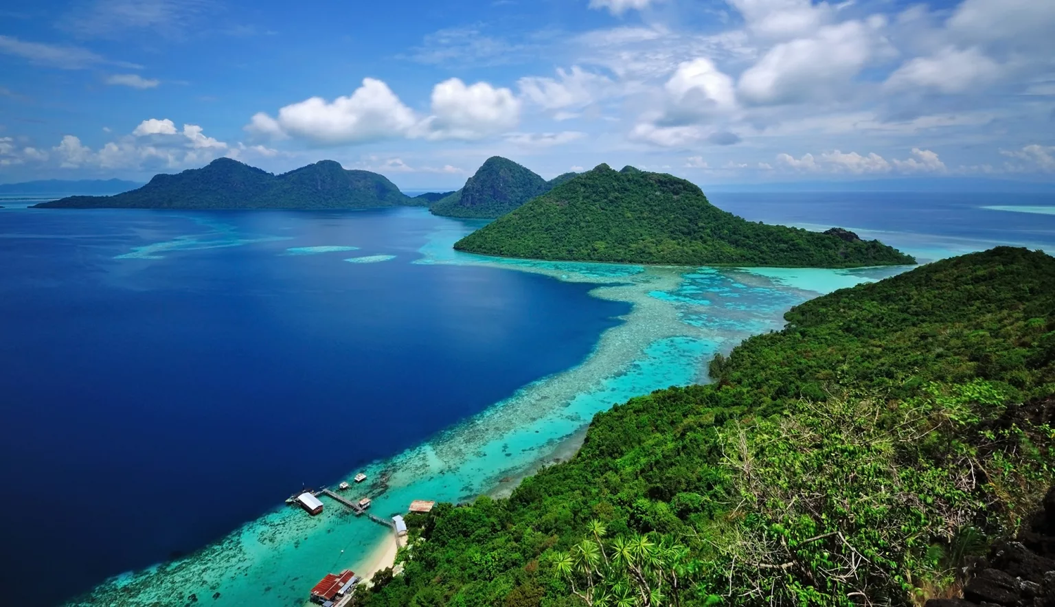
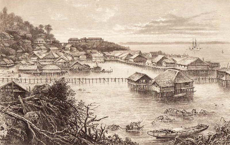
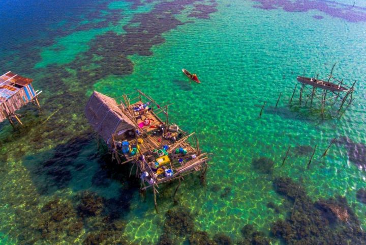
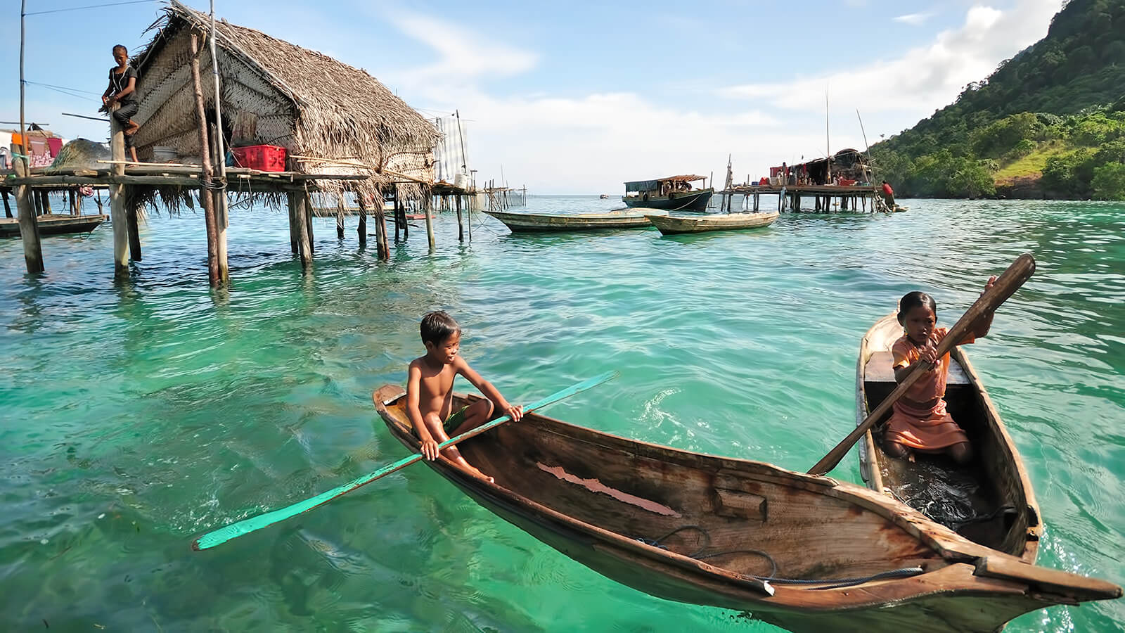
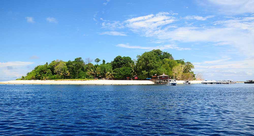
The town of Semporna is a staging point for visitors while going to dive or snorkel at the nearby islands of Mabul, Mataking, Sipadan, Maiga, and Kapalai. A characteristic feature of Semporna is the stilt houses referred to as water villages. Tourists can also explore nearby regions and some natural and historical spots outside the town. At a 15-minute drive from Semporna is Bukit Tengkorak, which is an archaeological heritage site. This also opens up many hiking and trekking opportunities for those who fancy it.

Semporna was founded soon after the British North Borneo Chartered Company established Sandakan, and was initially settled by Chinese traders, most fleeing from Spanish attacks on the Sulu Sultanate. Before being named Semporna, this area was known as Tong Talun in the Bajau language which means Hujung Hutan in Malay or at the end of the forest in English. It was renamed Labuan Semporna which is Malay for perfect anchorage but the word Labuan was subsequently dropped. Other sources translate Semporna as a Peaceful Place.

Including other parts of eastern Sabah, this area was ruled by the Sultanate of Sulu before being handed over to the British North Borneo Chartered Company in 1876 by agreement. From then, the area came under permanent British administration. Other Western powers, including the Dutch, tried to conquer this area in June 1876 but were repelled by the British presence here. This area also was long a main landing point for pirates. Very few people lived on the coasts for fear of these marauders. Action by the British, Dutch and Spanish managed to successfully combat the pirates throughout the 1800s. Upon the advent of the Chartered Company in the early 1880s, only one pirate stronghold remained at Omadal Island, which was defeated by HMS Zephyr in 1886. By mid-1887, a trading station on the southern side of the entrance to Darvel Bay was established. With pirates having recently destroyed the settlement of Maimbung in Sulu, some of the Chinese merchants there asked for permission to settle in the Company’s territory, under the rule of law and its resulting security. Semporna was the site of a small-scale migration of Chavacano speakers from Zamboanga, fleeing the Malaysia-funded Moro Conflict between Muslim rebels and the Philippine government. These Chavacanos speak a Creole of Mexican-Spanish and are partially descended from Peruvian settlers mixed with indigenous Filipinos from the former Rajahnate of Sanmalan.

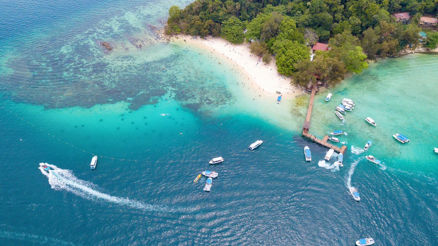
Semporna is located at the tip of Semporna Peninsula around Lahad Datu Bay, also known as Darvel Bay, and is visited by tourists as a base for scuba diving or snorkelling trips to Pulau Sipadan or Sipadan Island, some 36 km southeast of town. Semporna is also known for the Regatta Lepa traditional boat races which occur annually in April.

While peak diving season is between April and November, diving is possible all year round in Semporna. The clear waters around the islands in the Semporna Island Park, also known as the Tun Sakaran Marine Park, are great spots to explore the variety of aquatic life found on the island. Further, Mabul Island and Kapalai Island house cuttlefish, mandarin fish and pygmy seahorses, among others.

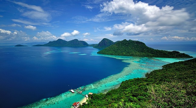
Comprising eight islands, the Tun Sakaran Marine Park features multiple dive sites. The waters around the islands off the east coast of Sabah are home to barracudas, eagle rays, turtles, parrotfish, and nudibranchs. Hikers are in for a fun time at the park as well, with the chance to hike uphill and explore the lagoon in Bohey Dulang. Tourists can also visit the Tun Sakaran Marine Research Unit, home to a seaweed farming centre and a clam spawning centre.

Also known as Semporna Islands Park, in 2004, the Tun Sakaran Marine Park became the seventh gazetted area under Sabah Parks with a total area of 350 sq km. Approximately 2,000 people live within the park, most of whom consist of the nomadic Bajau Laut or Sea Gypsies people, who live in stilt houses and houseboats in and around the marine park. To this day, out of the eight islands, there is only one island, Sebangkat that has an owner and legal grant holder after the gazetting in 2004.

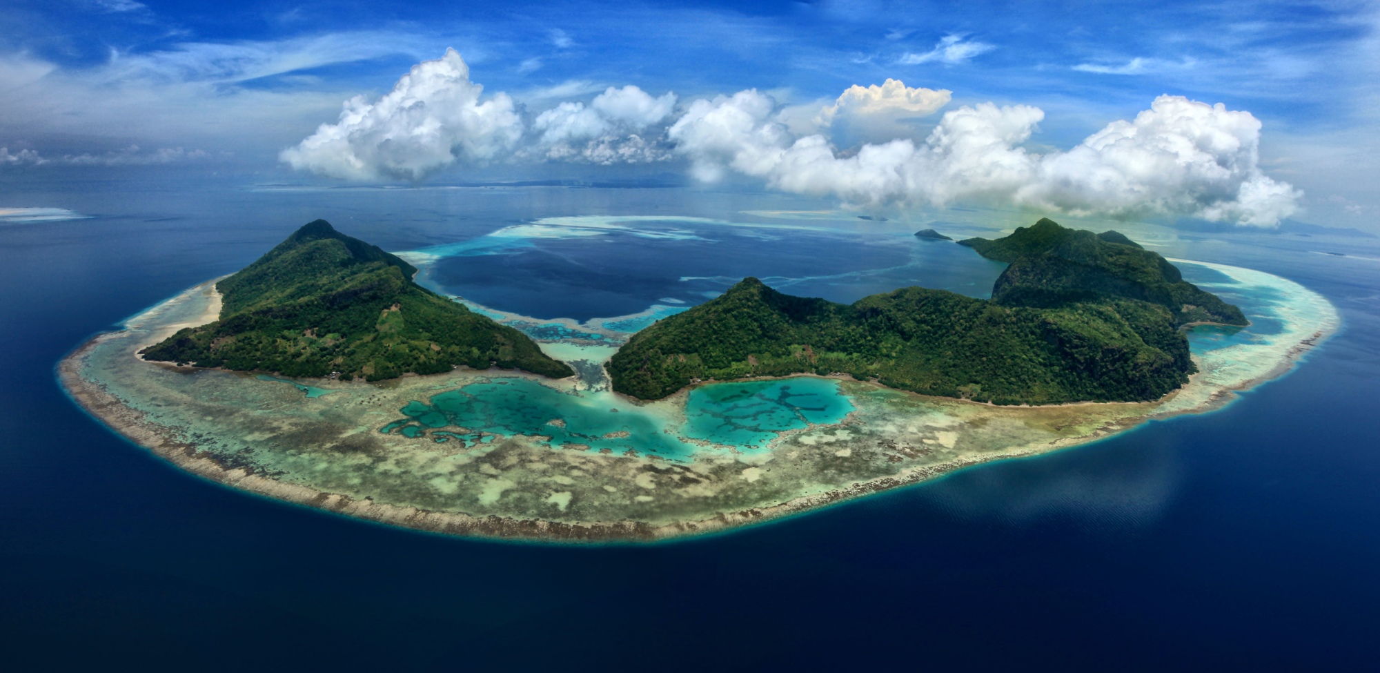
23 km from Semporna, Bohey Dulang island, is the second largest island in the Tun Sakaran Marine Park archipelago. Bohey Dulang is a hiker’s paradise, with uphill treks to the island’s peak and a lagoon that opens into the sea there to explore. The island is also home to birds such as hornbills, fruit doves, babblers, metallic pigeons, scrub fowls, and the like, making it an excellent spot for birdwatching. In addition, the Tun Sakaran Marine Research Unit houses a seaweed farming centre and a giant clam hatchery. The island is home to the nomadic sea gipsy people, known locally as the Bajau Laut.

Sipadan National Park, on the Celebes Sea off the east coast of Sabah, is a top diving destination, located at the centre of the Indo-Pacific basin. With turtles, sharks, triggerfish, crevalle jackfish, barracudas, and trevally fish found here, the waters are home to one of the richest marine habitats in the world. However, the deep diving points and underwater currents mean Sipadan is more suited to advanced divers.

Located 10 km south of Semporna, Skull Hill, locally known as Bukit Tengkorak, is a volcanic rock shelter site as well as an important archaeological site. The slopes of the hill have shards of pottery that have been traced back to over 3000 years ago. The hill is an open archaeological site, with a museum at the base housing various findings from the site. The hill used to be one of the largest sites of pottery making in Asia during the Neolithic period, a practice that continues with the Bajau people of Semporna.

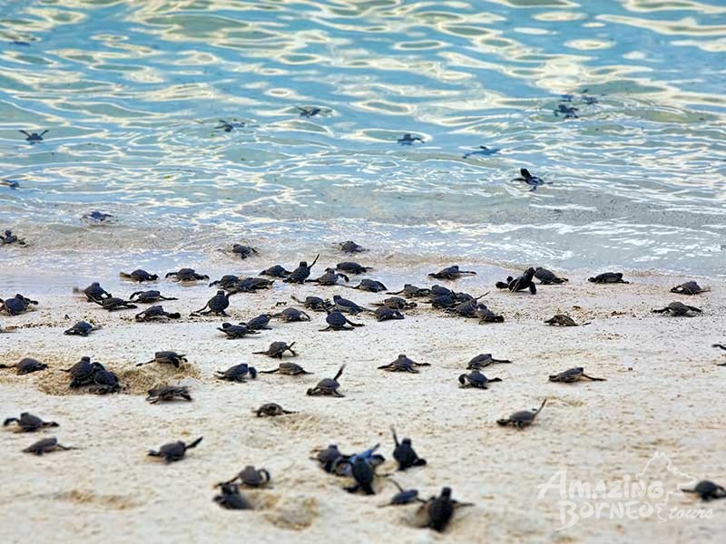
The Tropical Research And Conservation Centre at Semporna aims to restore coral reefs and protect sea turtles from fish bombing practices followed by locals. Tourists can volunteer to help the organisation and construct frameworks for corals, monitor and protect green and hawksbill turtles move their eggs to the hatchery, and patrol the islands to protect marine life. As volunteers, tourists can also enjoy scuba diving as well as relaxing on the white sands of the beach.
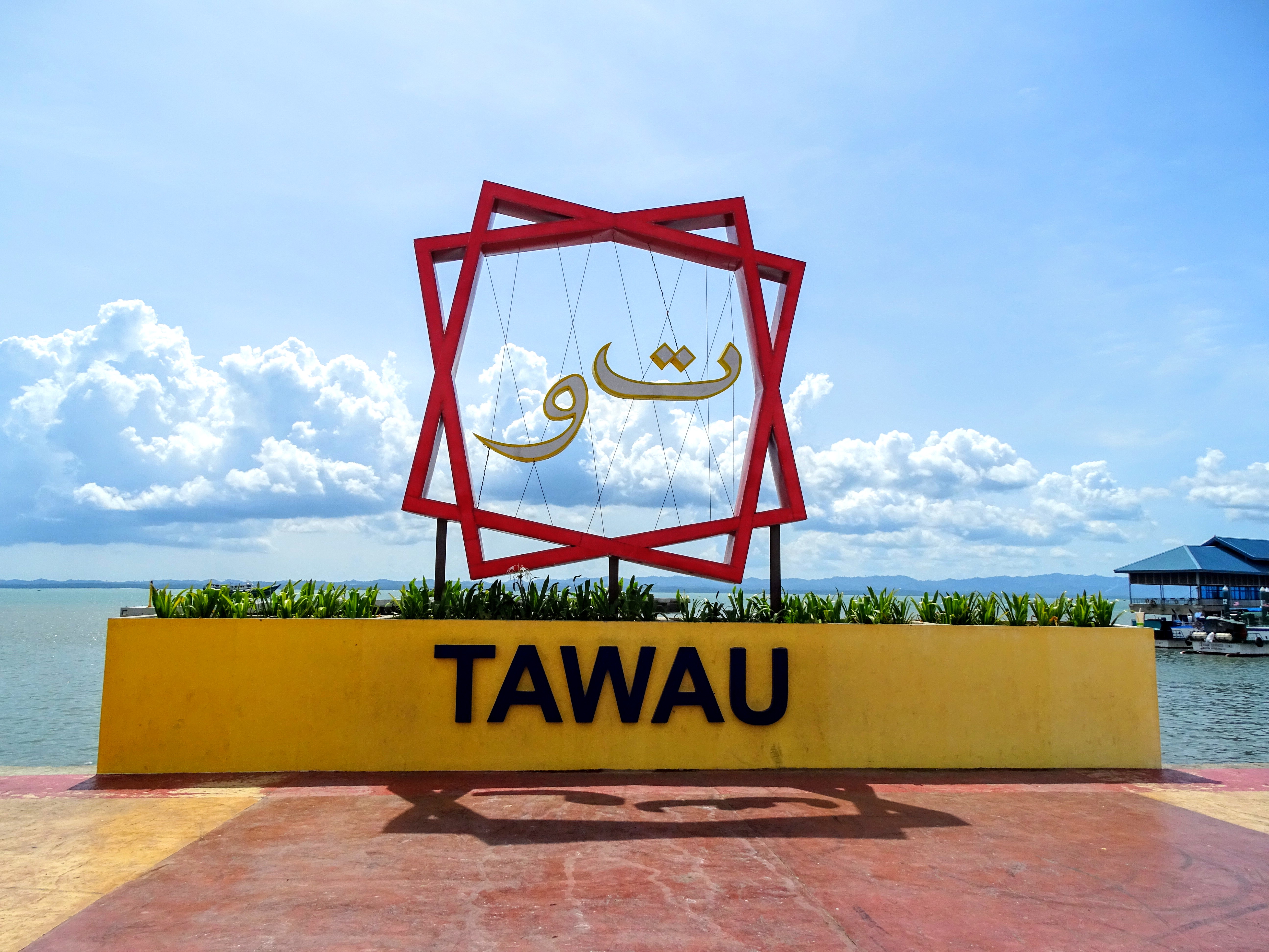
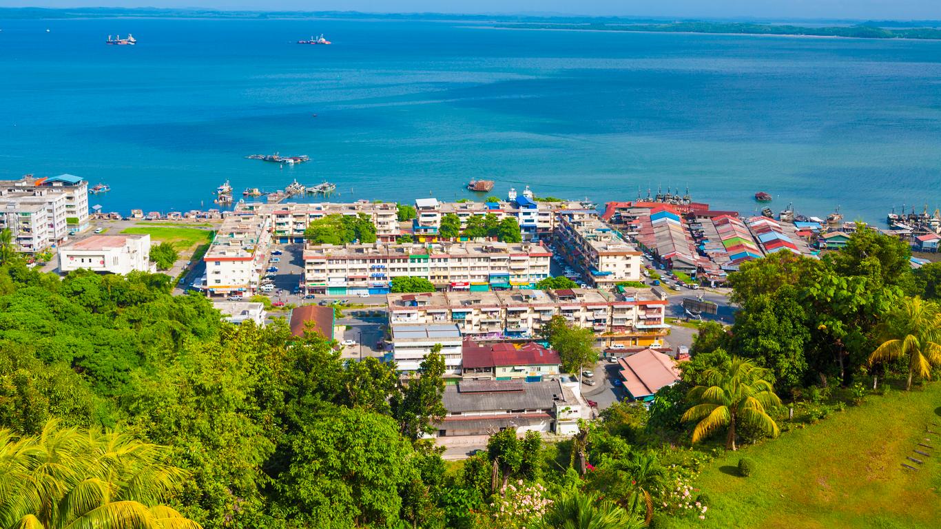
Tawau
Formerly known as Tawao, Tawau is the third-largest city in Sabah, after Kota Kinabalu and Sandakan. It is bordered by the Sulu Sea to the east, the Celebes Sea to the south at Cowie Bay and shares a border with North Kalimantan, Indonesia.

Before the founding of Tawau, the region around it was the subject of dispute between the British and Dutch spheres of influence. In 1893, the first British merchant vessel sailed into Tawau, marking the opening of the town’s seaport. In 1898, the British set up a settlement in Tawau. The North Borneo Chartered Company, BNBC accelerated the growth of the settlement’s population by encouraging the immigration of Chinese. Consequent to the Japanese occupation of North Borneo, the Allied forces bombed the town in mid-1944, razing it to the ground. After the Japanese surrender in 1945, 2,900 Japanese soldiers in Tawau became prisoners of war and were transferred to Jesselton. Tawau was rebuilt after the war, and by the end of 1947, the economy was restored to its pre-war status. Tawau was also the main point of conflict during the Indonesia–Malaysia confrontation from 1963 to 1966. During that period, it was garrisoned by the British Special Boat Section, and guarded by Australian Destroyers and combat aircraft. In December 1963, Tawau was bombed twice by Indonesia and shootings occurred across the Tawau-Sebatik Island international border. Indonesians were found trying to poison the town’s water supply. In January 1965, a curfew was imposed to prevent Indonesian attackers from making contact with Indonesians living in the town. While in June 1965, another attempted invasion by the Indonesian forces was repelled by bombardment by an Australian destroyer. The military conflict finally ended in December 1966. The main economic activities of the town are timber, cocoa, oil palm plantations, and prawn farming.

The Tawau Hills National Park was established in 1979, primarily as a protection for the water catchment area of Tawau. It is located 24 km north of Tawau and comprises 279.72 sq km of lowland dipterocarp rainforest, surrounded by oil palm and cacao plantations. The park offers picnic areas, camping sites, and chalets and contains rugged volcanic landscapes including hot springs and spectacular waterfalls. The highest point in the park is Gunung Magdalena at 1310 m.

The newly opened 9 km long trail to the World’s second longest rainforest tree at a height of 96.7 m is also located here. All this makes Tawau Hills Park an ideal place for gatherings like picnics, campings and night stays. The River Lodges at the park are a popular accommodation option which gives a serene view of the river and the park.

The most popular spot of Tawau Hills Park is the Bukit Gelas Waterfalls, which are 2.5 km from the Lodge and take about an hour to cover. The trail is easy except for the last 200 m which is an adventurous climb up the slope. A 200 m walk from the park’s main entrance will take one to the very famed Table Waterfalls with a natural swimming pool. The nature trail to the sulfur Springs is mostly flat, at a distance of 3.2 km from the Lodge. However, the latter half of the trail is hilly. The natural trail to the Sulphur Springs gets divided from the natural trail of Bukit Gelas Waterfall at the juncture of the suspension bridge. To reach Sulphur Springs, one must cross the suspension bridge and take the climb up the muddy hills. The natural trail to the mountains is a three-day guided forest trail to extinct volcanoes covering a total distance of 17 km. It covers a visit to Gunung Magdalena and Gunung Lucia along with Bukit Gelas Waterfalls, Sulphur Springs and Kerangas Forest. Gunung Magdalena is the highest peak in Tawau Hills Park with a height of 1312 m. The trail to Mount Magdalena is 14 km and is the longest trail. As it is a three-day trek, 2 nights are to be spent at the hostel located 10 km into the trail. This trail also includes a tour to Gunung Lucia which is the second highest peak with a height of 1202 m. The trail to Gunung Maria is another alternative for a shorter and faster hike. It is the third-highest peak with a height of 1067 m. It is compulsory to hire a guide on all trails and special permits are to be issued by Sabah Parks before the commencement of the climb to these trails. The easy jungle walk to 530m high Bombalai hills takes about 30 minutes. One can witness panoramic views of the park from these hills. The sight is breathtaking with a view of Tawau town along with Cacao and Palm oil plantations.

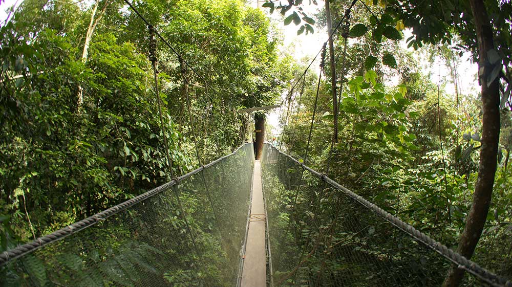
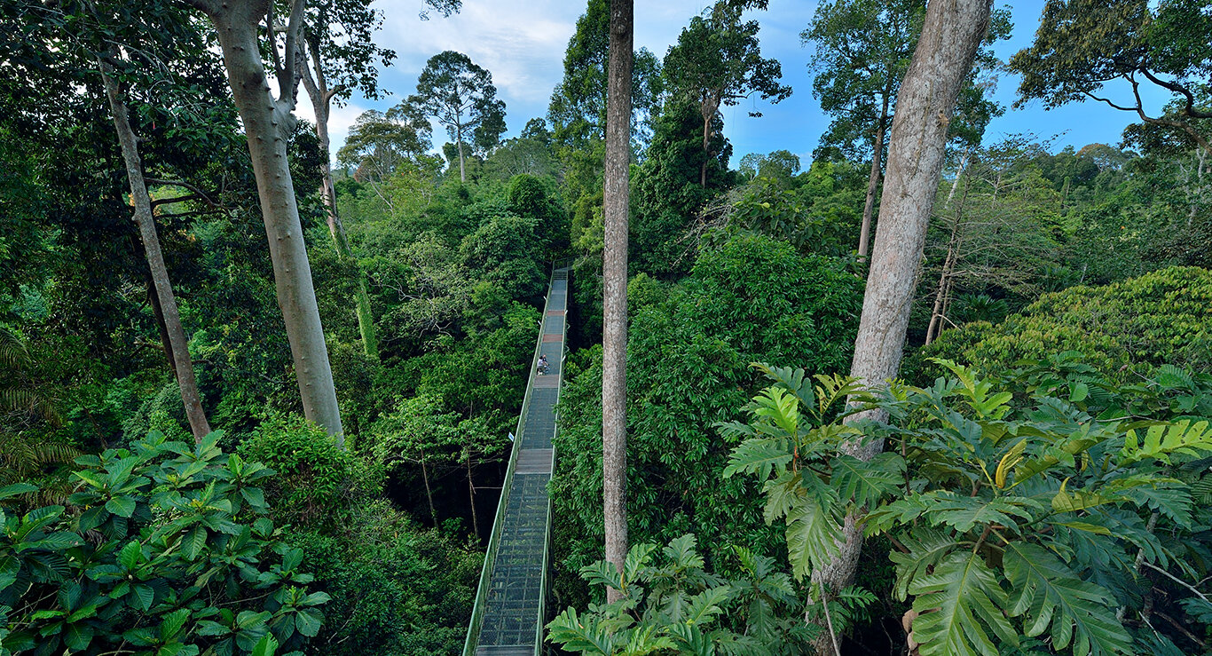
With 180 species of birds, Tawau Hills Parks is one of the major spots for birdwatching. Black hornbills, bushy crested hornbills, crested-fireback pheasants, helmeted hornbills, rhinoceros hornbills, great argus, white-crowned hornbill, Malayan peacock pheasants and wreathed hornbills can be spotted here. The Bukit Genop Canopy Walk is an easy 1 km jungle trail to a 231 m long canopy walk which gives an amazing view. The park arranges for night walks with professional guides to see nocturnal animals in their natural habitat. However, the night walk requires pre-arrangements and separate fees. The newly opened 9 km trail takes the adventurers to the 96 m high tree of Tawau Hills Park.

It is recommended to make prior reservations as the resort can accommodate only a limited number of people. Supplies and accommodations are arranged accordingly by the park administration. One may visit it for a day- trip or spend a few nights at the park.

There is only one accommodation service provider at the park, that is, Tawau Hills Resort. It has several staying options like Chalets, Droms, Lodges and a Hostel. There is one jungle lodge and one mountain lodge. The Hostel is located at a distance of 10.5 km from Mount Magdalena Trail with facilities like a kitchen, bathroom and furniture while other accommodations are located at the entry of the park.

Entry Fees at RM 3 for adults and RM 1 for children who hold Malaysian passports, while foreigners pay RM 10 for adults and RM 6 for children. The park is open daily from 7 am to 6 pm.

Bukit Gemok is a popular trekking spot about 10 km from the centre of Tawau. The Bukit Hill canopy walk situated inside the forest reserve is to look out for. Sprawling across an area of about 231 m, this canopy walk is regarded as one of the longest canopy walks in Sabah and provides a panoramic view of Tawau town. One can find wild plants such as forest orchids in addition to commercial timber. Further, endangered species such as the Chinese Egret and hornbills can also be found here. Bukit Gemok shares its boundary with cocoa plantations and palm oil. Basic facilities such as rest tents and washrooms have been installed inside the forest reserve.

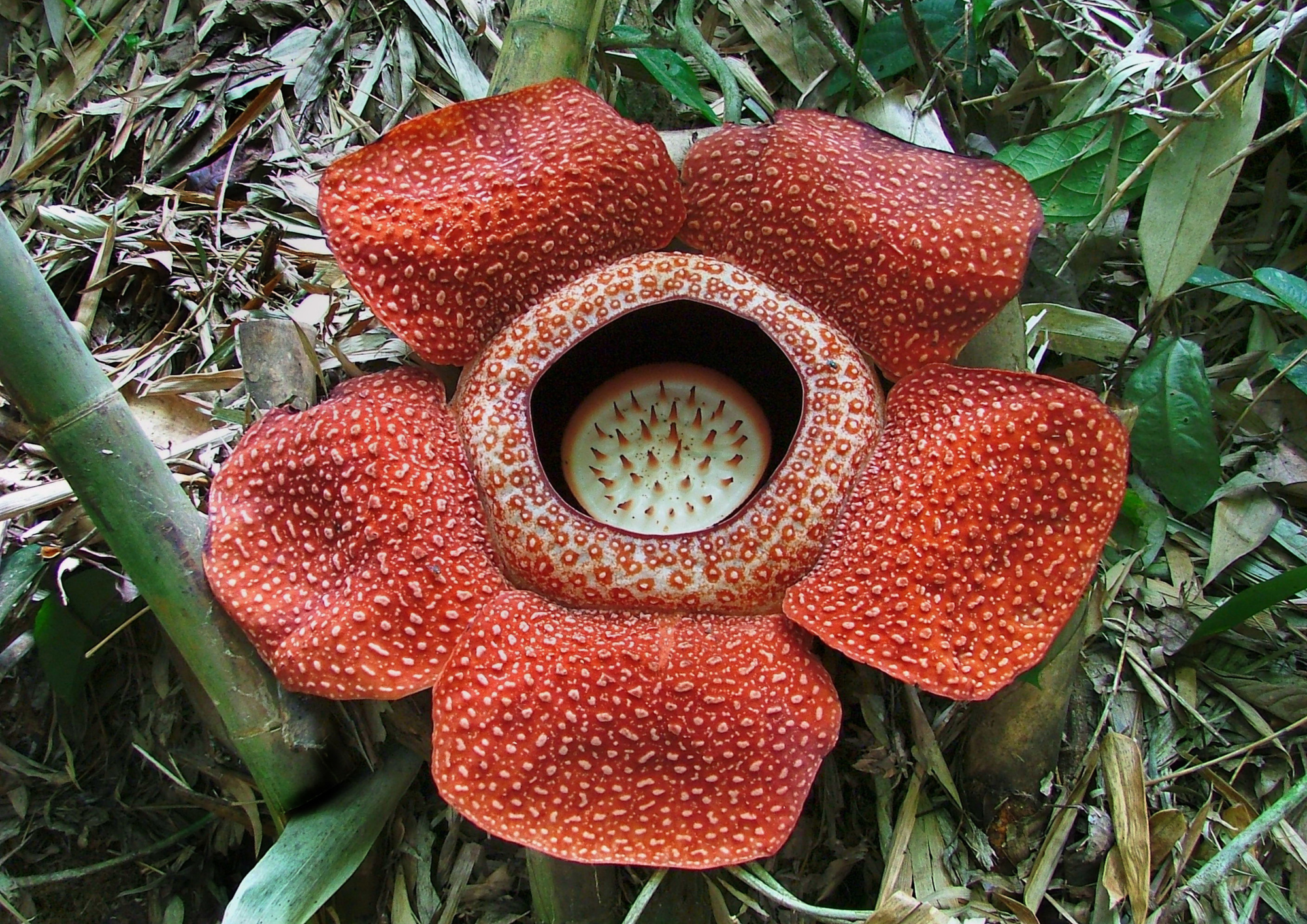
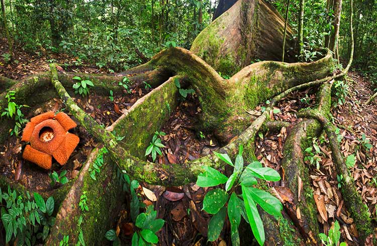
The Maliau Basin, reaching 1675 metres above sea level at its highest point, is one of Malaysia’s richest and most diverse wildlife areas. A 4-hour drive from Tawau, this isolated region seems like a completely different world, with its unique ecosystem. Along with over 1800 species of trees, the Rafflesia flower, and the carnivorous Pitcher Plant, one can come across rare species of animal life such as orangutans, Sumatran rhinos and pygmy elephants. For the hikers, operators often organise four or five-day-long hikes thoroughly exploring the Maliau Basin.

The Maliau Basin Conservation Area is a 25-km wide bowl-shaped catchment depression which is now a popular rainforest. It is one of the world’s greatest biodiversity zones housing almost 2000 types of flora and fauna. Maliau Basin attracts adventurers, trekkers and naturalists. The River Maliau flows into the Kinabatangan River, making the Basin extremely prestigious. The water catchment was gazetted as a Class I Protection Forest in 1997.

Popularly known as Sabah’s Lost World, the forest lives up to the name as it is almost deserted, apart from the seasonal hikers and adventurers. The rainforest bowl covers an area of 58840 hectares, with numerous waterfalls and campsites. The terrain is quite rough for a beginner, but the basin and views make up for it.

Entrance fees range from around RM 4000 for 4 days. One will need to apply for visitation permission online from the Park HQ several months before visiting the forest. However, one can also get a permit given at the park entrance. A guide service is needed to cover the basin. Documents are required to be shown to assess the level of physical fitness to trek the basin reserve.

Trails to the various camps, Maliau Fall and Mount Lotung are often explored during the dry seasons between January to July. The forest has around 70 km of trails leading to the main fall and other paths that lead to Mt. Lotung, which staggers a height of 5469 ft above sea level. Groups are likely to usually hike around the basin and camps.

Agathis Camp marks the commencement of the trail. It used to previously be mostly abandoned because of the elephants. A bench area and a devastated old building are all that remain now. Nepenthes Camp or the Camel Trophy Camp is about 7-8 km from the Agathis Camp. Nearby are the Takob Akob Waterfall and the Giluk Waterfall, which one can visit on the way. The observational station at the camp provides a mesmerizing view of the forest. Ginseng Camp is about 9 km from Agathis Camp and is situated right next to the Ginseng waterfall. One can spend the night at the camp and swim by the falls to feel rejuvenated. The seven-layered Maliau EWaterfall lies at the heart of the Maliau Basin.

Some very rare and endangered species that only reside in Borneo, belong to the Maliau Basin forest including the nearly extinct Sumatran rhinos and pygmy elephants. The canopy rainforest is filled with various kinds of vegetation including the rarely occurring aquilaria trees, agarwood, pitcher plants and Rafflesia flowers.

Situated in the Tawau Highlands, the mountainous Ulu Kalumpang Forest Reserve is 35 km from Tawau. Covering over 500 square kilometres, the forest reserve is home to many endangered species, including the critically endangered orangutan. There are about 183 orangutans in this reserve, isolated from the rest of the world in an attempt to encourage survival. The forest reserve is home to 5 different forest types.

The Tawau Hot Springs are a set of 8 sulphur hot springs occurring along a 50-metre stretch of a mountain stream. The water of this stream is hot and strongly acidic, with a distinct smell of hydrogen sulphide. Locals bring food offerings to the springs, and they believe the water of the springs is capable of curing skin diseases and illnesses.

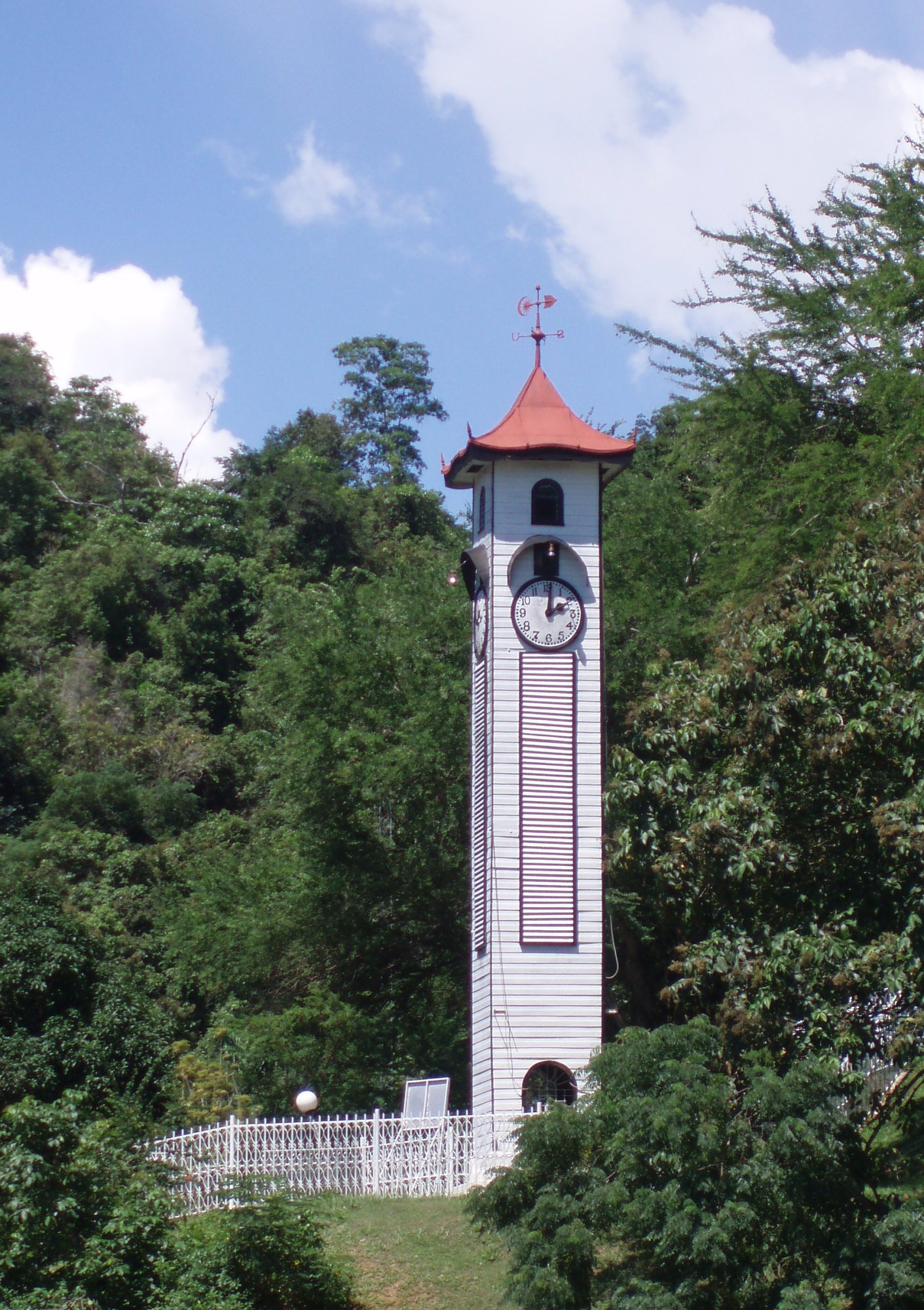
The Tawau Bell Tower, also known as the Belfry, is the oldest standing structure in the town, whose history dates back to 1921. This tower was built by the Japanese to commemorate the armistice agreement which took place after the First World War. Prison labour was used to construct the tower, and funds were contributed by Japanese businessmen in Tawau. As the abandoned structure recently was almost near collapse, it was restored with funds contributed by the Rotary Club of Tawau in 2006.

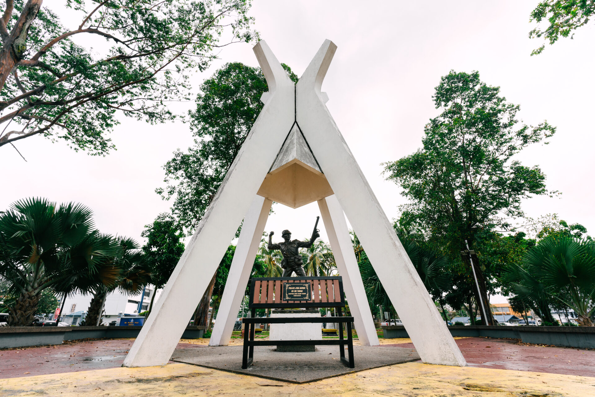
The Confrontation Memorial was built after the Indonesian-Malaysian confrontation, an undeclared war that took place between 1963 and 1966. The memorial was built to pay respect to those who lost their lives to protect the country.

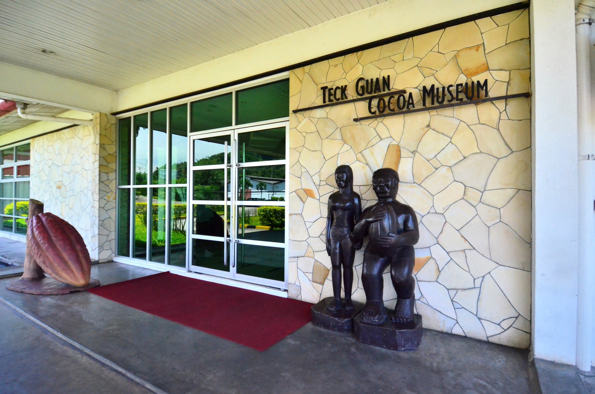
Tawau is known for its cocoa production, and the one-of-a-kind Teck Guan Cocoa Museum showcases the development of this industry in the region. The museum has a cocoa processing plant and manufacturing factory within its compound, and one could take educational tours and learn about raw cocoa processing. In addition, there are cocoa products and chocolates available for sale, and visitors can also sample a few of them. The museum needs bookings for visits.

Open from early morning until about 6 pm, the Pasar Tanjung Tawau is located at the centre of Tawau and hosts 6,000 stalls. The market prides itself on selling products at much lower prices than in Peninsular Malaysia. Dried seafood is a specialty, and visitors can buy dried and salted anchovies and shrimp here. Visitors can also sample delicacies indigenous to the Sabah region.

The Tawau International Cultural Festival is an annual cultural event that showcases the talent and art of ethnic Malaysian groups. This festival features artist presentations, cultural performances, and several other forms of art. Celebrations in the form of parades and fireworks also form a part of this colourful and vibrant festival. The Tawau International Cultural Festival is generally celebrated in the first half of the year i.e. January to April.

And with this, after more than a year, we come to the end of what Malaysia has in store for visitors. I have put quite a few places on my bucket list. And you?

Travel Bucket List: Malaysia Part 55 – Sabah Part 4

Sandakan
Formerly known at various times as Elopura, Sandakan is the second largest city in Sabah after Kota Kinabalu and is located on the Sandakan Peninsula on Sabah’s east coast.

Before the founding of Sandakan, the Sulu Archipelago was the source of dispute between Spain and the Sultanate of Sulu for economic dominance in the region. By 1864, Spain had blockaded the Sultanate’s possessions in the Sulu Archipelago. The Sultanate of Sulu awarded a German consular service ex-member a piece of land in the Sandakan Bay to seek protection from Germany. In 1878, the Sultanate sold north-eastern Borneo to an Austro-Hungarian consul who later left the territory to a British colonial merchant. The German presence in the area raised concern among the British. As a result, a protocol was signed between the British, German and Spanish to recognise Spanish sovereignty over the Sulu Archipelago, in return for the Spanish not intervening in British affairs in northern Borneo.

Sandakan began to prosper when the British North Borneo Company, BNBC started to build a new settlement in 1879, developing it into an active commercial and trading centre as well as making it the main administrative centre for North Borneo. The British also encouraged the migration of the Chinese from British Hong Kong to develop the economy of Sandakan. However, the prosperity halted when the Japanese occupied the area. As the war continued and Allied bombing started in 1944, the town was destroyed. Unable to fund the costs of the reconstruction, the administrative powers of North Borneo were handed over to the Crown Colony government. Subsequently, the administrative capital of North Borneo was moved to Jesselton.

The first European settlement was built by a Scottish arms smuggler from Glasgow named William Clark Cowie who named the settlement Sandakan, which in the Suluk language means the place that was pawned. It was soon renamed Kampong German, due to the presence of several German bases there. When another new settlement was built shortly after the previous Cowie settlement had been destroyed by a fire, it was called Elopura, meaning beautiful town by the British North Borneo Company but the locals persisted in using the old name and later it was changed back to Sandakan. Besides Elopura, it was also nicknamed Little Hong Kong due to the strong presence of ethnic Chinese migration from Hong Kong, mainly Cantonese and Hakka.

Sandakan is one of the six districts that is involved in the Eastern Sabah Security Command or ESSCOM, a dusk-to-dawn sea curfew which had been enforced since 19 July 2014 by the Malaysian government to repel attacks from militant groups in the Southern Philippines. Sandakan is located about 28 km from the international border with the Philippines.

The Kinabatangan River is one of the most prominent and accessible places in Asia to see a variety of flora and fauna. The river is home to more than 200 bird species and more than 50 mammals along with ten primate species. The significant animals are the proboscis monkey and the Bornean gibbon. The river is about 560 km long and is Malaysia’s second-longest river. The name Kinabatangan is a reference to the early Chinese trades who settled around the river mouth of the river. The word Kina is a direct reference to the Dunsun tribe of the Chinese settlers. Chinese traders had settled in the river mouth of Kinabatangan since the 7th century and used trading as a means to live their livelihood. Visitors can opt for a boat ride from Sandakan Yacht Club to the Sukau Rainforest at 1 pm. The boat ride to the lodge takes less than 3 hours and visitors can also get a glimpse into Borneo’s wildlife and natural beauty.

The Kinabatangan River basin has five different habitats: waterlogged forests, saline swamps, dry forests, freshwater swamps, and limestone forests. The distinct habitats allow wildlife to thrive and are home to several hundred species. The Kinabatangan Wildlife Sanctuary was founded in 2006 and safeguards 27,800 hectares of the area.

The river cruise is the top thing to do at Kinabatangan River. Several tour packages have different cruises at different price ranges. It’s a magical experience and visitors will be left in awe when they see the sunrise in the river. There are 3 river cruises every day and visitors can choose their ride timing according to their convenience. Timings for the River Cruises are 6 am, 4 pm and between 7 and 9 pm. The morning hours are great for visitors who want to gaze at birds while evening time is great for visitors who want to watch monkeys and crocodiles. The nighttime River Cruise ride is great for visitors who want to experience the river at night while observing the nocturnal animals.

The jungle Trek is an activity for adventure seekers only. Oxbow Lake is the prominent trekking site in this area and visitors are recommended to do planning before they begin the trek. Gomantong Cave is a bat haven and home to many swiftlets. The cave is an impressive wonder and is also a hotspot for several other animals, particularly orangutans. However, the cave is also full of cockroaches and faeces which can be disgusting for visitors. The river is one of the best spots to watch animals and birds thrive in their natural surroundings. The most prominent bird in this part is the Hornbill, which can be spotted easily. The Orangutans and wild monkeys are the more common animals found in this area.

The best time to visit Kinabatangan River would be March to September as this period foresees the least rain which can allow visitors to enjoy their trip more. This is also the best time to spot Orangutans and other forms of wildlife. The dry climate of these months allows visitors to spot more wildlife and travel more comfortably.

The Sandakan Heritage Museum is located on the 1st floor of the Wisma Warisan building, next to the Sandakan Municipal Council and is part of the Sandakan Heritage Trail. The museum showcases the pre-war and post-war history of the town—various artefacts including barter trade items, authentic office equipment in the 1920s and traditional agricultural equipment. Portraits of local leaders and early scenes of the town are prominently displayed with the most eye-catching being the large mural of Sandakan in 1935 in the museum’s hallway. The Martin and Osa Johnson Safari Museum in Chanute, Kansas, United States has relations with the museum with the digital copies of the Johnson photographs related to North Borneo are returned to the museum and the authority of Sabah Museum.

The Agnes Keith House, formerly known as the Newlands is a historic house museum named after Agnes Newton Keith, an American author known for her three autobiographical accounts of life in British North Borneo. The house was already constructed on a hill in the current site as a British colonial government quarters. In 1934, Agnes married Harry Keith, a British official forest conservation officer in Sandakan. After being destroyed in World War II, a new house was rebuilt between 1946 and 1947 on the hill of a destroyed house and became the first government permanent timber dwelling. The newly rebuilt house was renamed Newlands. Agnes lived in the house for several years before the house was owned by others. After being left unoccupied, the Sabah Museum Department together with the Federal Department of Museum and Antiquities began to collaborate in 2001 to restore the house and on 26 April 2004, it was finally opened to the public as a museum.

Agnes wrote about mysterious incidents throughout her stay where she saw a tall unrecognisable female figure apparition. The next occupant also experienced similar incidents. The house has been restored and turned into a heritage house since the restoration works in 2004. The house provides insights into life during the administration of British North Borneo and is furnished with a reproduction of colonial furniture and antiques. A gallery on the first floor tells the story of Agnes, her books and her family.

The Chartered Company Monument is a monument dedicated to the British servicemen or employees who were killed at the end of the 19th century. The monument was built by the British North Borneo Company and is part of the Sandakan Heritage Trails, a trail which connects the historic sights of Sandakan.

The Chinese Cemetery in Sandakan sprawls across a huge area and is regarded as one of the most fascinating burial grounds in Asia. One part of the cemetery is dedicated to the Chinese. Here, the graves follow the old feng shui principles. There is also an ancient charnel house which houses the remains of extended Chinese families. These houses depict Taoist guardian deities which protect the departed spirits from negativity. Another section of the Chinese Cemetery houses the remains of the Japanese community.

The Sandakan Japanese Cemetery is an old graveyard located on a hill about 2 km from the town’s central business district. It is a cemetery where many Japanese female prostitutes, known as Karayuki-san who came from poverty-stricken agricultural prefectures in Japan are buried. These young women were sold into slavery at a very young age years before World War II which also included recent comfort women during the war. It is part of the Sandakan Heritage Trail.

The Sandakan Massacre Memorial consists of three monuments which commemorate 30 Chinese victims, most of whom were the local elite of an underground movement executed on 27 May 1945 along with several other victims during the Japanese occupation of North Borneo. The memorial was built on the spot where the massacre took place and where the victims were buried. It is located near a Chinese cemetery on a hill above the old town centre of Sandakan. The memorial is located near the entrance to the Sandakan Chinese Cemetery. Right next to the gate, it is surrounded by a tiled square of six metres long. Link chains connected by stone pillars limit the memorial, which consists of approximately three metres high stele and two flanking memorial stones.

The Sandakan Memorial Park is a memorial site built on the former grounds of the former Sandakan camp. The site is dedicated to the prisoners in the camp who died during the Sandakan Death Marches, and to those who died during a march to Ranau. It also recognises the suffering and sacrifice of the native population. This park hosts the Sandakan Memorial Day service on August 15.

The memorial park is located about 1.5 km southwest of present-day Sandakan Airport, which occupies part of the former camp of the Australian B Force. The memorial is divided into six stations that are connected by a circular route. The excavator was used for the construction of an airport for the Japanese. During repairs, it was sabotaged by Australian prisoners of war rendering it inoperable and so it never worked again. The steam generator and other generators became the main power source for the camp. The wood-fired steam engine-powered generator was used for the lighting of the camp and its enclosure. The Great Tree is a huge specimen of a Mengarisbaumes that originally stood where the memorial obelisk is placed today. It was the dominant structure of the POW camp by its size. Shortly after the war, the tree was destroyed by a fire. A new Mengarisbaum was planted near the entrance on 25 April 2008 for the park. The Japanese also operated a food depot and kitchen with a water tank preserved in concrete. The main entrance was on the east side of the memorial park before the storage area. The road leading to the airport and to the left and right was the Mile 8 Road street from Sandakan to Ranau. It was from here, that all three marches began to Ranau. The Sandakan Commemorative Pavilion was opened on 18 March 1999 and contains a permanent exhibition about the POW camp and the death marches in both English and Malay languages.

The Sandakan War Monument is a monument established by the British to commemorate citizens who died during the Second World War. The monument is part of the Sandakan Heritage Trails, a Heritage Trail which connects all of Sandakan’s historic sights.

The William Pryer Monument is a monument in memory of the founder, William Burgess Pryer. It is part of the Sandakan Heritage Trails, a trail which connects all the historic sights in Sandakan. The monument site changed frequently. In the 1950s, the monument stood on a square that today is known as the site of the Sandakan Municipal Council. In the early 1960s, the monument was located near a field and later relocated again when Sandakan North Road was converted into a four-lane road. Its current location is on MPS Square, fronting the Municipal Council building along with other monuments such as the Chartered Company Memorial after the transformation of the site, which was a former hockey field.

St. Mary’s Cathedral or Sandakan Cathedral, is the cathedral and mother church of the Roman Catholic Diocese of Sandakan. Founded in 1883, it is the oldest church in Sandakan. During the 19th century, it was erected as a prefecture based in Labuan. In the period established in the territory of the various mission stations, including the mission of Santa Maria of Sandakan, a small town on the coast of the island of Borneo.

The Sam Sing Kung Temple, also known as the Three Saints Temple is the third oldest temple in Sandakan after the Goddess of Mercy and Tam Kung Temples. Built in 1887, the temple is part of the Sandakan Heritage Trail. The temple has undergone several recent renovations. The temple was originally established as a religious centre for Chinese migrants who had arrived from Guangdong, and the Qing Dynasty. The temple is also called the Three Saints Temple with the three saints referring to Kwan Woon Cheung, the saint of righteousness, the Goddess of Tin Hou who is worshipped by fishermen and seamen for protection, and the Min Cheong Emperor who is worshipped by hopeful students who seek success in examinations. The temple has a collection of 100 pre-printed Taoist Divination Poems. Its bronze bell was donated by the first Kapitan Cina of Sandakan, known as Fung Ming Shan who was appointed by the British rulers in 1887 to manage and oversee the Chinese community in the town.

Nestled on the Tanah Merah hill, the Puu Jih Syh Temple is the largest Chinese temple in Sandakan. The highlight is the panoramic view of the Sandakan city and the Sulu Sea from this Buddhist-Chinese temple. Kuan Yin, the Goddess of Mercy and Passion is the principal deity. The temple is adorned with shades of red and golden, while its roofs are adorned with paintings of Chinese dragons. Traditional Chinese architecture, gleaming lanterns, a huge variety of flowers, statues and Buddhist intricate works further accentuate its beauty.

The Sandakan Jamek Mosque, also known as Masjid Jamek Sheik Hasabollah At-Tohiri and was opened in 1890. It is the oldest mosque in Sandakan and part of the Sandakan Heritage Trail. The mosque was opened in 1890 by Damsah, a Muslim cloth merchant from the British Raj in present-day India. During World War II, the mosque was a hidehole for the town’s Muslim population from the Japanese. The Japanese military believed the mosque was also the hiding place for British soldiers leading them to shoot the mosque several times during the war.

Turtle Islands Park is located within the Turtle Islands, which lie in the Sulu Sea some 3 km north of Sandakan. It consists of 3 islands – Selingaan, Little Bakkungan and Gulisaan, including the surrounding coral reefs and ocean. The Park is noted for its green turtles and hawksbill turtles which lay their eggs on the beaches of the islands. The Park covers an area of 17.4 sq km. The name Turtle Islands, however, refers to 10 islands, 3 of which are part of Turtle Islands Park of Malaysia, and 7 which belong to the Turtle Islands Wildlife Sanctuary of Tawi-Tawi province, Philippines.

Only on Selingan are there chalets for overnight visitors, and those who wish to see the turtles laying eggs must stay overnight. A curious fact of the three islands is that turtles come ashore nightly, not only during certain seasons and thus one is virtually guaranteed to see them. During the peak season in October, up to 50 turtles come ashore to lay eggs. Park rules are strictly enforced and visitors are not allowed on the beach from sunset to sunrise so as not to disturb the turtles. The eggs are collected and the visitors vacate the beach immediately so as not to scare away other turtles, which are very sensitive to movement on the beach. After the laying and collection of eggs and eventual tagging of the turtle, if it is a first-time visitor, tourists are allowed into the hatchery to observe the further work of the rangers: the transplantation of the freshly laid eggs into a man-made incubation chamber. The chamber is no different from that of the turtle: between 60 and 75 cm deep, in the sand, but within a protected hatchery to make it impossible for natural predators to dig the nests open. Since temperature determines the sex of the turtles, part of the hatchery is shaded, while the rest remains under the open sun. After the transplantation of the eggs, visitors will get turtle hatchlings—baby turtles—to release into the sea, which is also done by night to further increase their chances of survival.

Not all nests are emptied by the park rangers, but some remain undisturbed and develop naturally. By conserving the turtles, the park does not want to endanger other wildlife on the island: many animals that are natural predators of the turtles, such as monitor lizards, a crab specialising in turtle hatchlings, eagles and other birds, and marine animals such as sharks. They need the turtles for their survival. The turtle conservation programme in Sabah is the oldest in the world and has the most detailed statistics and research. Marine turtles have been around for at least 230 million years, but because of human activities, they have been brought, over the past hundred years, to the brink of extinction.

The Gomantong Caves are an intricate cave system inside Gomantong Hill and the hill is the largest limestone outcrop in the Lower Kinabatangan area. Situated in the Gomantong Forest Reserve, the caves and the surrounding area are a protected area for wildlife, especially orangutans. The limestone hill is also the only known site for the endangered land snail Plectostoma mirabile. Investigation of the guano deposits was first made in 1889 by J.H. Allard of the China Borneo Company, and the caves were first mapped by P. Orolfo in 1930. Detailed re-mapping and laser scanning of the caves was conducted in 2012 and July 2014.

The bat population is dominated by a colony of the wrinkle-lipped free-tailed bat, whose nightly exodus is a popular tourist attraction. There are also bat hawks that linger not far from the scene and prey specifically on the bats as they leave their roost.

For centuries, the caves have been renowned for their valuable edible swiftlet nests, which are harvested for bird’s nest soup. The most valuable of the nests, the white ones, can sell for very high prices. The birds’ nest collection is an ancient tradition, and the trading of these nests has been done since at least 500 AD. Twice a year, from February to April and July to September, locals with licenses climb to the roof of the caves, using only rattan ladders, ropes, and bamboo poles, and collect the nests. The first collection takes place early in the breeding season before the swiftlets lay their eggs. The birds then make another nest in which they finally lay their eggs. After the young have left the nest, the second collection is made. Care must be taken to ensure that the nests are collected only after the young swiftlets have abandoned these nests. Edible birds’ nests are protected under the Wildlife Conservation Enactment of 1997. Heavy fines and penalties are imposed on unlicensed collectors.

The main cave system is divided into two parts: the more accessible Simud Hitam or Black Cave, and the larger Simud Putih or White Cave which lies above. The names refer to the main type of nests produced by swiftlets in each cave. The cave system is home to many other animals, including massive populations of cockroaches, centipedes and bats. Outside one can see many raptors including crested serpent eagles, kingfishers, and Asian fairy-bluebirds. Access is in the form of a wooden walkway circuiting the interior.

Simud Hitam or Black Cave the more accessible of the two caves is only a few minutes walk from the entrance building and is open to the general public. It is the source of the less-valuable black saliva nests. These contain both feathers and saliva and require cleaning afterwards. Simud Putih or the White Cave is the larger of the two caves, and also the more technical; it is not open to the general public, and access requires appropriate caving equipment and experience. It is where the more valuable white saliva nests of the swiftlets are found and is reached by a steep, 30-minute climb further up the mountains. The main entrance is located above and adjacent to the main lighthole at the back of Simud Hitam.

Travel Bucket List: Malaysia Part 54 – Sabah Part 3

The Signal Hill Observatory Tower, located just outside the main town provides astounding views of Kota Kinabalu. The observatory platform is a high-roofed platform located shaped in the form of a UFO at the edge of Signal Hill overlooking Kota Kinabalu and the South China Sea. The observatory allows visitors to get a panoramic view of Likas Bay and the Tanjung Aru areas surrounding it and provides one of the best scenic views of Kota Kinabalu.

The Sabah Art Gallery or Balai Seni Lukis Sabah in Malay is an art gallery founded in 1984 by Datuk Mohd. Yaman Hj. Ahmad Mus. The building consists of two gallery spaces. The permanent exhibition of the art gallery houses more than 3,000 artworks by local and international artists with a total estimated value of around more than MYR10 million. The temporary gallery houses various exhibitions. Besides exhibitions, the gallery regularly hosts workshops, seminars, competitions etc.

Sabah’s state museum, the Sabah Museum is located on 17 hectares of land at Bukit Istana Lama. The original Sabah Museum location was established on 15 July 1965 in a shophouse in Gaya Street largely due to the efforts of the Sabah Society. George Cathcart Woolley’s collection of photographs, diaries and other artefacts, bequeathed to the State Government of Sabah, formed the nucleus of the museum. The complex contains not only the museum proper but also an ethnobotanical garden, a zoo and a heritage village. The main building also houses the Sabah Art Gallery. Other galleries cover Islamic civilisation, archaeology and history, natural history, and ceramics and brassware. The mission of the museum is to collect, preserve, conserve and document ethnographic, archaeological, historical, numismatic, art-historical, botanical, zoological and mineralogical collections from throughout the state, and to conduct research on important and interesting aspects of Sabah’s history, culture, and social and natural history.

Merdeka Square is a square located from where the Federation of Malaysia was declared in 1963. The square was the site for sporting events during the British North Borneo Crown period. Before the Jesselton Community Hall was built in the 1950s, the square was not just used as a football field but also became a parade site, especially before the construction of the Kota Kinabalu Sports Complex. On 16 September 1963, the late Chief Minister Donald Stephens declared the formation of the Federation of Malaysia at the site. Since then, the square is only used for small ceremonies. In 2015, the square was closed for several months for renovation work. On 23 February 2018, it is one of 24 heritage sites in the state that were gazetted by Sabah’s State Heritage Council under the new enactment of State Heritage Enactment 2017.

The Petagas War Memorial or Petagas War Memorial Garden is a memorial park dedicated to the Second World War victims in Sabah, particularly the 324 resistance movement members, who were executed on 21 January 1944 at the site by the Japanese occupying forces of North Borneo for their involvement in the Jesselton Revolt. The park was built on the site where the massacre took place and where the victims were initially buried. On 21 January 1946, the Chinese War Victims Relief Association, CWVRA held a memorial service at the execution site on the second anniversary of the massacre. The park grounds and marble memorial were built in 1948 at the behest of the West Coast Memorial Fund Residential Committee, WCMFRC. At the same time, it was decided that the site of the massacre and its burial sites should be a permanent place of remembrance for all North Borneo’s victims of World War II. The inauguration of the memorial took place on the fourth anniversary of the massacre on 21 January 1948. In 1949, the remains of the men who were murdered by the Japanese military police, kenpeitai and interred in Labuan were reburied at Petagas. Since the opening of the Petagas War Memorial site, an annual memorial service has been held on 21 January with the participation of high-ranking state politicians, families of the victims and the general population. At the 1998 service, a representative of the Japanese government and the Japanese consul in Kota Kinabalu attended the ceremony for the first time.

The Double Six Monument is a memorial located in the Sembulan neighbourhood which marks the site of the 6 June 1976 fatal plane crash known as the Double Six Tragedy bearing the first Chief Minister of Sabah, Tun Fuad Stephens, as well as six other State ministers.

Tanjung Aru Beach, located near the west coast of Kota Kinabalu is one of the most iconic attractions in Sabah. It is a great place for all types of visitors, from couples to families. Tanjung Aru Beach is one of the best spots to catch a breathtaking sunset. The beautiful beach is divided into three parts, and are known as the First, Second and Third Beaches respectively. With lively music and entertainment everywhere, the nighttime at Tanjung Aru Beach is a stark contrast to its beautiful daytime vibes.

First Beach is located next to the Shangri-La’s Tanjung Aru Resort and Spa and is the most popular beach in Tanjung. There are plenty of food stalls and restaurants in First Beach and it is always buzzing with visitors. It features an open food court and offers a variety of delicacies to its visitors. Tourists are also allowed to use the barbeque pits at the beachfront to cook their meals. Second Beach is a great spot to catch the sunset. However, it is advised to look out for jellyfish as it is quite common around these areas. Third Beach in Tanjung Aru Beach is a great spot for surfers and the beach also provides surfing lessons on the beach.

The Kota Kinabalu Waterfront is a mixed development project with a mall, hotels, restaurants, resort homes and a boardwalk between Filipino Market and Oceanus Mall. Also known as KK Waterfront, it is situated in the heart of the city offering an unmatchable experience of the mesmerising sunset, nightlife and an array of restaurants, bars, and small eating and massage joints.

Bustling with the hustle of locals and tourists, the Gaya Street Sunday Market is a weekly market set in Gaya Street. It has been an important place for farmers, fishermen and other traders for more than a hundred years. The Sunday Street Market is famous for providing a large number of unique, handcrafted, organic and herbal items along with plants, flowers, stylish and colourful clothes, jewellery and other items of local, cultural and traditional importance. The market opens early in the morning and one can stroll around to shop and also try the authentic Malaysian and international cuisine at the roadside stalls.

Tucked into Patau Village’s virgin forests, Mahua Waterfall sits inside Crocker Range National Park. It is a plunge-type waterfall cascading from a height of 17 metres and is among Sabah’s best ecotourism attractions for trekking and camping. In addition, there is a 1.2-metre-deep natural pool for swimming. The waterfall is open from 8 am to 6 pm and has an entry fee of RM 15 per person.

Kota Kinabalu Wetland Centre is 24 hectares of the only remains of mangrove forest that once existed extensively along the coastal region of Kota Kinabalu. Previously known as Likas Swamp or Likas Mangrove and later Kota Kinabalu City Bird Sanctuary, the Centre came foremost out of 20 wetlands selected by the Sabah Wetlands Inventory Committee in 1986. The Centre is an important refuge and feeding ground for many species of resident birds, as well as several migratory bird species from Northern Asia. In addition, it is a breeding ground for marine life protected by the Fishery Department of Sabah.

Apart from providing shelter and food for both resident and migratory species of wildlife, wetlands also prevent salt build-up in surrounding freshwater supplies, stabilising sedimentation, storing nutrients and removing toxins. More than 80 different species of birds have been identified in the wetlands so far. Tourists are also thrilled to spot many colourful butterflies, mudskippers, weaver ants, jellyfish, water snakes and other amphibian or aquatic animals within this region.

Walking amidst nature while being close to the city is a rarity that the visitors to this centre love to experience. Tourists marvel at the thick foliage and often come across many sea creatures with the chirping of birds and insects being the only sound heard inside the mangrove forest. The centre is reckoned as a paradise for avid bird watchers with numerous species of birds being spotted in the forested area during the morning hours or in the breeding season. Both local people, as well as tourists, are educated about the uses of mangrove forests and their importance. The voluntary guardian program is undertaken by voluntary workers who train nature lovers to take an active part in conservation. Enthusiastic participants are guided by the volunteers so that they get to understand the concept of ecology and the conservation of the mangrove. Most of the work is done indoors with the participants provided with extensive training. The centre is closed on Mondays and on other days is open from 8 am to 6 pm.

Lok Kawi Wildlife Park is a famous natural wildlife park that is divided into two sections – zoological and botanical and houses many species of flora and fauna. The zoological part of the park houses many animals while the botanical part of the wildlife park offers an opportunity for a nature hike and also a chance to witness various types of flowers and trees along with insects, some of them indigenous to Malaysia.

The Pulau Tiga National Park consists of a group of coral reef-ed islands surrounded by the South China Sea, opposite the swamps of the Klias Peninsula. The park has three main islands, as the name suggests. These islands were formed by eruptions of mud volcanoes, namely the Tiga Islands, Kalampunian Damit and Kalampunian Besar. The region had peaked its fame when the reality show ‘Survivor’ featured it in their documentary, naming it popularly as Survivor Island. The desert island national park covers an area of 158 sq km whilst being surrounded by Kota Kinabalu and Labuan. Tropical Pulau Tiga is a refreshing and isolated family or romantic weekend getaway destination from the mundane life with its mesmerizing beaches of white sand, crystal waters and bubbling mud pools.

Tiga Island has a lot of dense tropical vegetation in the area. The volcanic steam of methane and bubbling mud volcanoes can still be seen and experienced in many places here. Kalampunian Besar has some soft white sand beaches and crystal clear water along with wreathes of sandbar action all across the island that have been eroded spectacularly by the waves. Scuba diving and snorkelling are some of the more popular activities that happen here. Kalampunian Damit is a smaller island, a little larger than a humongous rock. The island is popularly known as Snake Island because of the poisonous slippery inhabitants that live here and is a mating location.

Pulau Tiga is well known for hosting ground-dwelling megapodes that bury their eggs in the sandy beaches. There is also a diverse marine life including sharks and barracudas, in the greenish–blue sea beaches of the islands, that one can spot while swimming or strolling down the sands. There is also an abundance of vegetation present in Pulau Tiga.

Diving and snorkelling are some of the most sought-after activities when the tide sets. The dive centre on the island provides a course for beginners and intermediate learners. One can spot the seven km of colourful coral reefs along the beaches. There is also a mangrove lagoon and two pole-like trees called the giant ranggu that one must see. There are various bubbling mud pools, scurries and mud volcanic caves that one can visit. The island is located 5 km southwest of Kota Kinabalu. The day trip takes a total of around 11-12 hours when travelling independently.

The Tunku Abdul Rahman National Park comprises a group of five islands located close to Kota Kinabalu. The park is spread over 4,929 hectares, two-thirds of which cover the sea. Before the Ice Age, it formed part of the Crocker Range mass of sandstone and sedimentary rock on the mainland. However, about one million years ago, the melting ice brought about changes in the sea level and parts of the mainland were cut off by the sea to form the islands of Gaya, Sapi, Manukan, Mamutik and Sulug. Evidence of this can be seen from the exposed sandstone of the coastline forming the cliffs, caves, honeycombs and deep crevices. The park was named after Tunku Abdul Rahman, Malaysia’s first Prime Minister.

The ferry station for visitors travelling to the islands in Tunku Abdul Rahman National Park is located in downtown Kota Kinabalu. This ferry terminal is also the departure point for patrons staying at either Manukan Island Resort, Gayana Resort or Bunga Raya Resort.

One of the biggest attractions of the islands is the wide variety of aquatic life found in the waters surrounding the islands, and travellers who love natural beauty and the underwater experience will love a trip to the marine park which has many attractive diving and snorkelling sites where incredible untouched reefs attract a multitude of aquatic animals. Some of the islands also have resorts where travellers can spend a few days, like in Gaya. One can also choose to set up camp with tents on the islands and spend the night under the stars.

The marine park is comprised of a total of five islands, all of which are a short boat ride away from each other. Gaya Island is named because it is the largest of the islands. Gaya means big, but even though it is the largest, it is not the most developed. It has light forest trails for trekking activities. At Manukan Island, the word Manukan means fish and is named for the varied aquatic life in its surrounding waters. It is the second-largest island in the park and the most developed. Sapi Island is named after the sound of a mowing buffalo. It is another one of the most developed islands in the park with the most services and amenities and tends to be the most popular island of all. Sulug Island is named for the Sulug people of Sabah. This is one of the least developed islands and has nearly no facilities. Mamutik Island is named for the wide array of seashells that can be found on its beaches. This is another one of the lesser developed islands and has few amenities, except for some basic forms of accommodation, but tends to be much quieter and is ideal for relaxation and snorkelling. The only way to reach the islands within the Tunku Abdul Rahman Park is by ferry. Every hour, boats depart from the Jesselton Point Ferry Terminal. A trip from Jesselton Point to the park takes about 15-20 mins, depending on the island. The first boats to the islands depart at 7:30 am and the last at 4:30 pm.

Mantanani Islands are a collection of three stunning islands with gold beaches and ringed with nearly untouched coral reefs, located off the northwest coast of Sabah. The islands are a perfect getaway from the city and have recently become increasingly popular among travellers and locals alike. The scenic Mantanani Islands have small resorts for those wishing the spend the night under the skies and maybe explore the scenic beauty at night. It also houses some of the most diverse aquatic life that travellers can experience for themselves through underwater activities like diving and snorkelling.

Crocker Range National Park was established in 1984, although the area had previously been under protection as a forest reserve. It covers the north-south Crocker Range, of 1200-1800 metre mountains in Sabah. In the vicinity of the park headquarters, there is a resort that provides accommodation and food services. Other visitor facilities such as an exhibition centre, insectarium, fernarium, observation tower and trekking trail can also be found. The park covers 1,399 sq km, making it the largest park in Sabah. The park consists of both hill and mountain forests, with many species of flora and fauna endemic to Borneo. Maintenance of this forest cover is essential to ensuring a pure water supply for many of the towns and communities in Sabah. The park contains at least five species of primates, such as the orang-utan, gibbons and the furry tarsier with its enormous round eyes, and extremely sociable long-tailed macaques. The Padas River bisects the range between Beaufort and Tenom.

The Rafflesia Forest Reserve is a Virgin Jungle Reserve, VJR that covers an area of 356 hectares in Tambunan. The reserve was first established in 1967 as part of the Crocker Range Forest Reserve and in 1984, it was made a separate reserve to protect the area’s Rafflesia flowers. The Rafflesia Information Centre is located along the road from Kota Kinabalu to Tambunan. Several sites with wild specimens of the parasitic flowering plant Rafflesia pricei are reachable via hiking trails from the centre. The reserve is home to many insect species endemic to Borneo.

Kudat
Located on the Kudat Peninsula, about 190 km north of Kota Kinabalu, Kudat is near the northernmost point of Borneo. It is the largest town in the heartland of the Rungus people which is a sub-ethnic group of the majority Kadazan-Dusun race and is therefore a major centre of Rungus culture. It is also notable for being one of the first parts of Sabah to be settled by Chinese Malaysians, particularly from the Hakka dialect group. Kudat is the northernmost Malaysian city.

What is now the Kudat, was originally named Tomborungan by the local indigenous Rungus. It was named after the Tomborungus River, which has since disappeared. According to local lore, when the early British settlers asked for the name of the place, the local Rungus people misunderstood them and thought that they were asking for the name of a species of coarse grass which grows in abundance in the area. The grass is known as kutad in the Rungus dialect. This was eventually corrupted to Kudat and replaced the old name of Tomborungan.

The original inhabitants of Kudat are the native Rungus people, a sub-group of the Dusun people, who traditionally lived inland in longhouse communities to stay beyond the reach of the pirates who frequented the coastline. In the late 19th century, Franz Witti, an explorer in the employ of the British North Borneo Chartered Company, discovered oil 26 km outside the present-day Kudat town. This may have been a reason why the Company chose Kudat as the site for their first settlement in British North Borneo. The town of Kudat was officially founded on 7 December 1881. Company officers began clearing the land with the aid of several Brunei Malays in preparation for the declaration of Kudat as the first capital of British North Borneo. This was eventually made official in 1882. The British settlers ensured that they would live in peace with their native neighbours by signing a peace agreement with Temenggung Kurantud, the then Chieftain of the Rungus people and Datu Harun, the then leader of the Muslim community of Kudat.

The company brought in foreign workers from China. During World War II, the Japanese Imperial Army built and maintained an airfield in Kudat with the help of locals and forced labour from Java, Indonesia. The runway was built using coral stones as a base. In 1945, the United States Far East Air Force repeatedly bombed the airfield putting it out of action. After World War II, Kudat received little attention from the rest of British North Borneo, having long been eclipsed by the rapid growth of Sandakan and Kota Kinabalu, then known as Jesselton. Exacerbating Kudat’s isolation was the fact that it was only accessible by sea until a road was built in the 1960s linking Kudat with Kota Kinabalu. Locals concentrated largely on the coconut and seafood industries until the 1990s when small numbers of visitors began coming to Kudat to experience traditional Rungus culture.

In the early 2000s, Kudat underwent a period of rapid development. A raft of projects gave Kudat several new hotels, a sports centre, the Sidek Esplanade and a new road linking the town with the Pan-Borneo Highway.

Kudat is home to a significant Hakka Chinese minority which is among the oldest Hakka communities in Sabah. Hakka involvement in Kudat began in the 1880s with Walter Medhurst’s offer of free passage to British North Borneo to prospective migrants in southern China.

The small but important tourism industry in Kudat town revolves largely around its laid-back atmosphere and its proximity to the sea. Visitors come to purchase its fresh seafood and experience the charms of a typical Sabahan country town. Tourist attractions located in the town proper include the Kudat Golf Club, Sidek Esplanade, central market and fish market. Kudat is famous for its beaches, which are among the most unspoilt in Sabah. Some of the better-known beaches include Bak Bak, Pasir Putih, Kalampunian and Torungkungan.

Kudat is also notable for its proximity to Tanjung Simpang Mengayau, a headland which forms the northernmost point of the island of Borneo. The Tip of Borneo marks the meeting point of the South China Sea and the Sulu Sea. The tip as part of the Kudat Peninsula was formed through the Kudat formation in the Early Miocene age.

The original name of Tanjung Sampang Mangazou comes from the language of the indigenous Rungus. The words Tanjung or cape, Sampang or union and Mangazou or battle refer to this location of a battle that occurred when the ethnic Rungus defended their territory against the attack from Moro Pirates. According to legend, this place was a favourite landing point for the pirates. Local Chinese people refer to the place as Den Foh Liew, which in Hakka means a lighthouse due to a lighthouse on a nearby island of Kalampunian Island that can be seen from here.

The tip is one of Sabah’s popular tourist attractions. Within the area, there is a park-like grounds with a Malaysian flag pole and a large bronze globe which opened in 2004. The bronze globe marks the location of the Borneo Island tip at latitude 7 degrees north and longitude 116 degrees east with a map featuring the island embossed in bronze and laid on a flat surface at an angle with inscriptions to mark the tip. Over the years, infrastructure and public amenities have been erected at the site including a public rest area with a café, souvenir shop and washrooms. The park-like grounds has become a place to view sunsets and full moons.

Several villages along the Kota Kinabalu – Kudat road each showcase one particular aspect of Rungus culture. In Kampung Gombizau, visitors can observe the production of honey and gathering of traditional Rungus herbs, whereas Kampung Sumangkap is famous for its gong-making industry. Kampung Bavanggazo on the other hand is noted for its traditional Rungus longhouses, which are part of a community project offering tourists the chance to experience and learn about the culture and lifestyle of the Rungus people. Rungus culture can also be experienced at the Misompuru Homestay Programme, which is centred around Kampung Minyak.

Travel Bucket List: Malaysia Part 53 – Sabah Part 2

Kota Kinabalu
Affectionately known as KK, Kota Kinabalu, Sabah’s capital was formerly known as Jesselton. The city is located on the northwest coast of Borneo facing the South China Sea. The Tunku Abdul Rahman National Park lies to its west and Mount Kinabalu, which gave the city its name, is located to its east.

In the 15th century, the area of Kota Kinabalu was under the influence of the Bruneian Empire. Historically, the Kadazandusuns called the area by the name of Dondoung. In the 19th century, the British North Borneo Company, BNBC first set up a settlement near Gaya Island. However, it was destroyed by fire in 1897 by a local leader named Mat Salleh. In July 1899, the place located opposite Gaya Island was identified as a suitable place for settlements. Development in the area was started soon after that; and the place was named Api-api before it was renamed after Sir Charles Jessel, the vice-chairman of BNBC, as Jesselton. Jesselton became a major trading port in the area and was connected to the North Borneo Railway. Jesselton was largely destroyed during World War II. The Japanese occupation of Jesselton provoked several local uprisings notably the Jesselton Revolt but they were eventually defeated by the Japanese. After the war, BNBC was unable to finance the high cost of reconstruction and the place was ceded to the British Crown Colony. The British Crown declared Jesselton as the new capital of North Borneo in 1946 and started to rebuild the town. After the formation of Malaysia, North Borneo was renamed as Sabah. In 1967, Jesselton was renamed Kota Kinabalu, Kota being the Malay word for City and Kinabalu after the nearby Mount Kinabalu. Kota Kinabalu was granted city status in 2000.

Kota Kinabalu is a major tourist destination and a gateway for travellers visiting Sabah and Borneo. Kota Kinabalu is named after Mount Kinabalu, which is situated about 50 kilometres east-northeast of the city. Kinabalu is derived from the name Aki Nabalu meaning the revered place of the dead. Aki means ancestors or grandfather, and Nabalu is a name for the mountain in the Dusun language. There is also a source claiming that the term originated from Ki Nabalu, Ki meaning have or exist, and Nabalu meaning the spirit of the dead. The word kota comes from Malay word kota which in turn comes from the Sanskrit word kota which means fort, fortress, castle, fortified house, fortification, works, city, town, or place encircled by walls. A direct translation of the name Kota Kinabalu into English would be the City of Kinabalu or Kinabalu City.

Besides Jesselton, there are also other older names for Kota Kinabalu. The most popular is Api-Api, or simply Api, which is a Malay word meaning Fire. Another suggested historical name is Deasoka, which roughly means below the coconut tree in the Bajau language. The Bajau locals purportedly used this name to refer to a village in the southern part of the city which was filled with coconut trees. Yet another name was Singgah Mata which means transit eye, but can be loosely translated as pleasing to the eye. It is a name said to have been given by fishermen from Gaya Island referring to the strip of land that is today’s downtown Kota Kinabalu. Today, all these names have been immortalised as names of streets or buildings around the city.

Kota Kinabalu is located on the west coast of Sabah. The city lies on a narrow flatland between the Crocker Range to the east and the South China Sea to the west. There are six islands off the coast of the city. The largest is Gaya Island, the site of the first British settlement. Approximately 8,000 people live there. The smaller islands, mainly uninhabited, are named Sapi Island, Manukan Island, Sulug Island, Mamutik Island and Sepanggar Island to the north. Sepanggar Island is located north of the National Park opposite Sepanggar Bay.

Besides being the capital city, Kota Kinabalu is also the main industrial and commercial centre for Sabah. The economy is dominated by the primary sector of industry. Historically, the secondary sector dominated the economy, but due to rapid urbanisation and economic development, this sector of the economy is slowly diminishing. More recently, a move towards a more tertiary-based industry has become more apparent, especially with the boom in the tourism industry.

Malaysia’s highest mountain, known as Gurung Kinabalu in Malay, Gayo Ngaran or Nulu Nabalu in Dusun, Mount Kinabalu is protected as Kinabalu Park, a World Heritage Site. Standing at a height of 4,101 m, this is the most accessible mountain in the world. The mountain and its surroundings are among the most important biological sites in the world, with between 5,000 and 6,000 species of plants, 326 species of birds, and more than 100 mammalian species identified. Mount Kinabalu has been accorded UNESCO World Heritage status.

Low’s Peak can be climbed by a person in good physical condition and there is no need for mountaineering equipment at any point on the main route, but climbers must be accompanied by accredited guides at all times due to national park regulations and may experience altitude sickness. Its vast altitude allows a wide array of habitats to thrive and is one of the world’s most important biological sites.

The climate of the mountain varies from humid tropical at its base to alpine at its summit. Due to the coldness of the mountain from December to January, there are a few occasions where frost and ice appear at the summit of Mount Kinabalu. Snow has been recorded three times in this area; in 1975, 1993 and 2022.

Mount Kinabalu gets its name from the Kadazan word Aki Nabalu which translates to the revered place of the dead. Mount Kinabalu is sacred to the locals as they believe that the spirits of their ancestors occupy the peak of the mountain. Initially, every time someone tried to climb the mountain, a chicken was sacrificed to pacify the spirits. However, this ritual takes place only once a year where seven chickens are sacrificed to pacify the spirits. Another popular legend among the locals is that the mountain belongs to a Chinese Widow. The legend says that a Chinese prince married a Kadazan woman after he defeated a dragon. However, soon after his marriage, he left for China thus abandoning the Kadazan woman. The woman then headed into the mountains where she was later turned to stone.

Ascending and descending the mountain can take up to 4 hours. However, visitors generally take two days with an overnight stay at Laban Rata, which is located 3,272 meters above sea level. Visitors generally try to reach the peak of the mountain by sunrise to catch the beautiful sun and capture sensational pictures.

The entry fee to enter Kinabalu Park is RM 15 for adults and RM 10 for children. A climb fee permit is charged at RM 200 for foreigners and RM 50 for Malaysians. A maximum of 120 people are allowed to climb the mountain each day to preserve the environment and for safety measures. Climbing permits are subject to availability so visitors are recommended to book their climbing packages in advance. Permits for the climb can be obtained from the tour guides or agencies. The cost of hiring mountain guide services is RM 230, while the porter service per day is RM 65.

Malaysia’s first national park, Kinabalu Park was opened to the public in 1964 and is today a UNESCO World Heritage Site by UNESCO. The park is buzzing with plant species such as the alpine meadow plants and montane oak.

It is one of the most important biological sites in the world with more than 4,500 species of flora and fauna, including 326 bird and around 100 mammal species, and over 110 land snail species. It covers an area of 754 sq km surrounding Mount Kinabalu, which is the highest mountain in Borneo.

The park contains a variety of flora and fauna that ranges over 4 climate zones; from rich lowland dipterocarp forest through the montane oak, and rhododendron, to the coniferous forests, to the alpine meadow plants, and the stunted bushes of the summit zone. The mountain is also known for its many carnivorous plants and orchid species, most notably Nepenthes rajah. It is also home to a multitude of endemic animal species, including the Kinabalu giant red leech and Kinabalu giant earthworm. The park also plays host to a variety of birds, insects, mammals, amphibians, and reptiles.

Mount Kinabalu is one of the youngest non-volcanic mountains in the world. It was formed within the last 10 to 35 million years. The mountain still grows at a rate of 5 millimetres a year. Kinabalu Park has eight nature trails for visitors who want to explore nature without trekking the mountain. There are several other attractions in the park such as the Orchid Conservation Center and the Butterfly Farm which will be an educative experience. One should not miss the waterfalls in the park, Kipungit Waterfall and Langanan Waterfall. The latter stands at 120m high and is a sight to behold.

April is the most preferred month for climbing the mountain as the weather is stable and is more suited for climbing. Visitors are advised to avoid climbing the mountain during November and December, as these months witness heavy rainfall which can make climbing difficult and dangerous.

Standing at 800 m above sea level, Kokal Hill is popular for its mesmerising city view, cool and fresh air, chilly temperatures and relaxing atmosphere. To get to the panoramic view, one needs to hike to the top which has resorts, cafes, homestays and a perfect location for landscape photography. Kokol Hill experiences a cool and pleasant climate mostly and is very crowded on clear days. It is best to visit around 6 am and in the evenings to experience the beautiful sunrise and sunset respectively.

The oldest standing structure in Kota Kinabalu, the Atkinson Clock Tower was originally known as the Atkinson Memorial Clock Tower and sits in solitary on the bluff along Signal Hill Road. The clock tower was built in memory of Francis George Atkinson, Jesselton’s first district officer who died of Malaria or Borneo Fever. His mother Mrs Mary Edith Atkinson presented a two-faced clock to Jesselton town as a tribute to the memory of her son and it was decided later that a clock tower would be built in his honour. The clock tower was originally built using Mirabau wood. Measuring 50 feet high, the clock tower stood from its lookout point on the hill facing towards the township of Jesselton. A weather vane with initials of the wind direction added a few more inches to the height of this elegant monument. Ships calling port at the wharf used the Atkinson Clock Tower as their navigation landmark, as it could be seen from the sea. The clock tower was illuminated at night and was used as a shipping landmark right up to the 1950s.  

Over the years, the clock tower underwent many transformations. Subsequent repairs and renovations have altered its appearance. Japanese machine-gun fire during World War 2 damaged the dial and cog of the clock tower’s mechanisms. The clock tower was extensively renovated and altered for Jesselton’s Diamond Jubilee celebrations in 1959. In 1961, the Atkinson Clock Tower’s clock face was altered yet again. The dials of the clock were changed and the face was replaced with translucent Perspex, with black figures on a white background for internal lighting. But the building itself has remained intact in its exact location for more than a century. The clock tower is protected with its site gazetted in 1983.

A cluster of traditional homes, the Mari Mari Cultural Village is popular for its tours and traditional art and craft displays. Murut, Dusun, Bajau and more are the communities scattered around Jin Kiansom, in Kota Kinabalu. One can witness tattoo-making, blow-pipe making and other indigenous crafts that these tribes engage in, as well as sample their cuisine and learn about their lifestyles and beliefs. While here, make sure to visit the Kiansom Waterfall which is close to the village.

The tour of the Mari Mari Cultural Village takes one through the vast area inhabited by the members of 5 different tribal communities. One can witness the various traditional activities and habits followed by each of these distinct tribes and their daily routines and rituals. Some of the fun activities included in the Mari Mari Tour include rice wine tasting, a unique method of cutting trees and blowpipe dart shooting which was once used as a means of defensive weapon but has now been turned into a harmless entertaining game. One can also volunteer for their special folk music and tribal ethnic dances like the Magunatip bamboo dance performed by the Murut tribes.

The Murut Tribe is one of the oldest tribal communities residing in the Mari Mari Village. They used to have quite a dominant grasp over the other tribes residing in and around the area due to their headhunting practices. They were also well-known for their fatal weapons like poisoned blowpipes, swords and ribbed spears coated with venom. One of their ancient traditions involved strategically placing the skeleton heads of those sacrificial humans to display their might to the neighbouring tribes and preventing any attempts of attacks or threats to the members of their tribe. However, after British colonisation, their population started decreasing rapidly and they became more domesticated leading them to turn into one of the friendlier tribes of the current times.

The Lundayeh Tribe, also called the Lun Bawang tribe, are a hard-working community of fishermen, livestock farmers, hunters and fishermen. They were infamous for their hardcore burak or rice wine drinking habits. In the early 20th century, there was a major smallpox epidemic which wiped out most of the Lundayeh tribe members. This was mainly due to their low immunity caused due to excessive drinking which made them more vulnerable to any kind of outbreaks. Today, the Lundayeh are considered almost extinct.

The Bajau tribal community has two subdivisions – about half of them residing in Kota Belud and the other half in Sempora. The Bajau tribes of Kota Belud are popularly known as the Cowboys of the East due to their skilled horse breeding and horse riding abilities. The Bajau Laut tribes of Semporna are fondly known as Sea Cusps due to their proficient sailing skills.

The Kadazan tribe is truly the people of the land. They cherish their produce and celebrate Kaamatan annually which they consider to be one of the most auspicious harvest festivals to honour and thank the agricultural deities. Most of the Kadazans are Christians, mainly Roman Catholics and a minority community of Protestants and Islamic followers.

The Rungus tribe was earlier considered to be a sub-community of the bigger Kadazan ethnic group until recently when they were declared to be a separate, independent tribal community that happened to be heavily influenced by Malaysian society. The entire community is quite heavily dependent upon rice harvest and processing making it their main source of income.

The cultural village is open from 10 am to 6 pm daily. Entry fees are RM 180 for adults RM 160 for children between the ages of 5 and 11.

The Japanese thermal pools at the Poring Hot Springs are part of the Kinabalu National Park and are a perfect way to relax after an exhaustive trek on Mount Kinabalu. The natural hot springs and the baths contain sulphur which is known for its skin-curative and restorative properties. The complex also has an enchanting forest filled with life, where a lucky few might even get to see some rare flora or fauna like the Rafflesia flower which only blooms rarely. Poring Hot Springs makes for a great trip for anyone looking for some adventure and the chance to attune to oneself.

The Poring Canopy Walk offers a chance to have a thrilling bird’s eye view of the entire spring complex from a height of 30 metres. It consists of a series of walkways suspended from trees in a circular shape. Visitors can opt to undertake an unguided trek through the forest complex to the Kipungit and Langanan waterfalls. The park complex also houses a beautiful butterfly park, located en route to the canopy walk. Another attraction for lovers of flora and fauna is the orchid garden within the park, home to a wide variety of orchids and also certain kinds of animals. The forest also has activities like bird watching that are highly enjoyable. The spring is open daily from 8 am to 6 pm.

The Kota Kinabalu City Mosque is the largest and second main mosque in Kota Kinabalu. Surrounded by a man-made lagoon, it is popularly known as the Floating Mosque because it appears to be floating on the water. The mosque is believed to be an epitome of Islamic architecture having been built in the lines of the Mosque Of Nabawi Al-Munawwara. It consists of a huge prayer hall along with three distinct madrasahs or Islamic schools with the capacity of accommodating up to 12,000 people at a time. Visitors are permitted to enter the mosque and look through it, however, they must register themselves with the Kota Kinabalu City Mosque Tourism Management first.

The dome of the mosque is striking and resplendent in gold and blue colours with the structure resembling Al Masjid an Nabawi, the second holiest mosque in the world. It is surrounded by an artificial lagoon that gave it the name of the floating mosque. Apart from 3 madrasahs and a prayer hall, a palliative care clinic as well as a fish farm. The mosque also introduced paddle boat rides for visitors in 2008. The mosque is open from 8 am to 12 noon and then again between 2 to 3:30 pm and 4 to 5:30 pm. It is closed on Fridays, but open all other days. Entry is free for Malaysians, but foreigners need to pay RM 5.

The Puh Toh Tze Temple is one of the most popular Buddhist temples in the country. The temple is adorned with traditional carvings and sculptures of the local deities. Built in the late 21st century, the temple was constructed to pay respect to and worship the Chinese goddess Kwan Yin, the Goddess of Mercy and Compassion, who is considered to be one of the most influential goddesses in the kingdom of Chinese deities. The architecture of this temple has gained its inspiration from the traditional Chinese designs and patterns making it one of the most popular tourist attractions at Kota Kinabalu. There are several intricate features in the temple. A massive stone staircase pavilion is flanked by statues of 10 deities on either side. However, the statue of Kwan Yin which greets visitors right as they cross the main entrance captivates their attention and dominates over the rest of the statues. Inside the temple is a huge Chinese laughing Buddha statue with miniature followers clinging onto him giving the statue a humorous touch. The walkway of Puh Toh Tze Temple houses the giant bell which is believed to have brought about good fortune to anyone who rings it.

Travel Bucket List: Malaysia Part 52 – Sabah Part 1

Located in the northernmost part of Borneo, Sabah has land borders with Sarawak to the southwest and Indonesia’s North Kalimantan province to the south. The Federal Territory of Labuan is an island just off Sabah’s west coast. Sabah shares maritime borders with Vietnam to the west and the Philippines to the north and east. Kota Kinabalu is the state capital, the economic centre of the state, and the seat of the Sabah State government. Other major towns in Sabah include Sandakan and Tawau. Sabah has an equatorial climate with tropical rainforests, abundant with animal and plant species. The state has long mountain ranges on the west side, which form part of Crocker Range National Park. The Kinabatangan River, the second longest river in Malaysia, runs through Sabah. The highest point of Sabah, Mount Kinabalu, is also the highest point in Malaysia.

The origin of the name Sabah is uncertain, and many theories have arisen. One theory is that during the time it was part of the Bruneian Sultanate, it was referred to as Saba because of the presence of a variety of banana called pisang saba, also known as pisang menurun, which is grown widely on the coast of the region and popular in Brunei. The Bajau community referred to it as pisang jaba. While the name Saba also refers to a variety of bananas in both Tagalog and Visayan languages, the word in Visayan has the meaning noisy, which in turn is derived from Sanskrit Sabhā, meaning a congregation, or crowd and related to a noisy mob. Due to the local dialect, the word Saba has been pronounced as Sabah by the local community. While Brunei was a vassal state of Majapahit, the Old Javanese eulogy of Nagarakretagama described the area in what is now Sabah as Seludang.

Although the Chinese have been associated with the island since the days of the Han dynasty, they did not have any specific names for the area. Instead, during the Song dynasty, they referred to the whole island as Po Ni, also pronounced Bo N), which is the same name they used to refer to the Sultanate of Brunei at the time. Due to the location of Sabah near Brunei, it has been suggested that Sabah was a Brunei Malay word meaning upstream or in a northerly direction. Another theory suggests that it came from the Malay word sabak, which means a place where palm sugar is extracted. Sabah is also an Arabic word, which means morning.

The presence of multiple theories makes it difficult to pinpoint the true origin of the name. It is nicknamed the Land Below the Wind or Negeri Di Bawah Bayu, as the state lies below the typhoon belt of East Asia and has never been battered by any typhoons, except for several tropical storms.

The earliest known human settlement in the region existed 20,000–30,000 years ago, as evidenced by stone tools and food remains found by excavations along the Darvel Bay area at Madai-Baturong caves near the Tingkayu River. In 2003, archaeologists discovered the Mansuli valley in the Lahad Datu District, which dates back the history of Sabah to 235,000 years. During the 7th century, a settled community known as Vijayapura, a tributary to the Srivijaya empire, was thought to have existed in northwest Borneo. The earliest independent kingdom in Borneo, supposed to have existed in the 9th century, was Po Ni, as recorded in the Chinese geographical treatise Taiping Huanyu Ji. It was believed that Po Ni existed at the mouth of the Brunei River and was the predecessor to the Bruneian Empire.

In the 14th century, Brunei and Sulu were part of the Majapahit Empire but in 1369, Sulu and the other Philippine kingdoms successfully rebelled and Sulu even attacked Brunei, which was still a Majapahit tributary. The Sulus specifically invaded Northeast Borneo at Sabah. The Sulus were repelled but Brunei became weakened. In 1370, Brunei transferred its allegiance to the Ming dynasty of China. The Maharaja Karna of Borneo then paid a visit to Nanjing with his family until his death. He was succeeded by his son, Hsia-wang, who agreed to send tribute to China once every three years. After that, Chinese junks came to northern Borneo with cargoes of spices, bird nests, shark fins, camphor, rattan and pearls. More Chinese traders eventually settled in Kinabatangan, as stated in both Brunei and Sulu records. A younger sister of Ong Sum Ping or Huang Senping, the governor of the Chinese settlement, then married Sultan Ahmad of Brunei. Perhaps due to this relationship, a burial place with 2,000 wooden coffins, some estimated to be 1,000 years old, was discovered in the Agop Batu Tulug Caves and around the Kinabatangan Valley area. It is believed that this type of funeral culture was brought by traders from Mainland China and Indochina to northern Borneo as similar wooden coffins were also discovered in these countries.

During the reign of the fifth sultan of Bolkiah between 1485 and 1524, the Sultanate’s thalassocracy extended over northern Borneo and the Sulu Archipelago, as far as Kota Seludong, present-day Manila, with its influence extending as far as Banjarmasin, taking advantage of maritime trade after the fall of Malacca to the Portuguese. Many Brunei Malays migrated to Sabah during this period, beginning after the Brunei conquest of the territory in the 15th century. But plagued by internal strife, civil war, piracy and the arrival of Western powers, the Bruneian Empire began to shrink. The first Europeans to visit Brunei were the Portuguese, who described the capital of Brunei at the time as surrounded by a stone wall. The Spanish followed, arriving soon after Ferdinand Magellan’s death in 1521, when the remaining members of his expedition sailed to the islands of Balambangan and Banggi in the northern tip of Borneo. Later, in the Castilian War of 1578, the Spanish, who had sailed from New Spain, which was centred in Mexico and had taken Manila from Brunei, unsuccessfully declared war on Brunei by briefly occupying the capital before abandoning it. The Sulu region gained its independence in 1578, forming its sultanate, known as the Sultanate of Sulu.

When the civil war broke out in Brunei between Sultans Abdul Hakkul Mubin and Muhyiddin, the Sulu Sultan asserted their claim to Brunei’s territories in northern Borneo. The Sulus claimed that Sultan Muhyiddin had promised to cede the northern and eastern portions of Borneo to them in compensation for their help in settling the civil war. The territory seems never to have been ceded formally, but the Sulus continued to claim the territory, with Brunei weakened and unable to resist. After the war with the Spanish, the area in northern Borneo began to fall under the influence of the Sulu Sultanate. The seafaring Bajau-Suluk and Illanun people then arrived from the Sulu Archipelago and started settling on the coasts of north and eastern Borneo, fleeing from the oppression of Spanish colonialism. While the thalassocratic Brunei and Sulu sultanates controlled the western and eastern coasts of Sabah, respectively, the interior region remained largely independent from either kingdom. The Sultanate of Bulungan’s influence was limited to the Tawau area, which came under the influence of the Sulu Sultanate before gaining its own rule after the 1878 treaty between the British and Spanish governments.

In 1761, Alexander Dalrymple, an officer of the British East India Company, agreed with the Sultan of Sulu to allow him to set up a trading post for the first time in northern Borneo, although this was to prove a failure. Following the British occupation of Manila in 1763, the British freed Sultan Alimuddin from Spanish colonisers and allowed him to return to his throne; this was welcomed by the Sulu people and by 1765, Dalrymple managed to obtain the island, having concluded a Treaty of Alliance and Commerce with the Sultan of Sulu by a willing Sultan Alimuddin as a sign of gratitude for the British aid. A small British factory was then established in 1773 on Balambangan Island, a tiny island situated off the north coast of Borneo. The British saw the island as a suitable location to control the trade route in the East, capable of diverting trade from the Spanish port of Manila and the Dutch port of Batavia, especially with its strategic location between the South China Sea and Sulu Sea. The British abandoned the island two years later when the Sulu pirates began attacking. This forced the British to seek refuge in Brunei in 1774 and to temporarily abandon their attempts to find alternative sites for the factory. Although an attempt was made in 1803 to turn Balambangan into a military station, the British did not re-establish any further trading posts in the region until Stamford Raffles founded Singapore in 1819.

In 1846, the island of Labuan on the west coast of Sabah was ceded to Britain by the Sultan of Brunei through the Treaty of Labuan, and in 1848 it became a British Crown Colony. Seeing the presence of the British in Labuan, the American consul in Brunei, Claude Lee Moses, obtained a ten-year lease in 1865 for a piece of land in northern Borneo. Moses then passed the land to the American Trading Company of Borneo, which chose Kimanis, which they renamed Ellena, and started to build a base there. Requests for financial backing from the US government proved futile and the settlement was later abandoned.

Japanese forces landed in Labuan on January 3, 1942 and later invaded the rest of northern Borneo. From 1942 to 1945, Japanese forces occupied North Borneo, along with most of the rest of the island, as part of the Empire of Japan. The occupation drove many people from coastal towns to the interior, fleeing the Japanese and seeking food. As part of the Borneo Campaign to retake the territory, Allied forces bombed most of the major towns under Japanese control, including Sandakan, which was razed to the ground. The Japanese ran a brutal prisoner-of-war camp known as Sandakan Camp for those siding with the British. The majority of the POWs were British and Australian soldiers captured after the fall of Malaya and Singapore. The prisoners suffered notoriously inhuman conditions, and amidst continuous Allied bombardments, the Japanese forced them to march into Ranau, which is about 260 kilometres away, in an event known as the Sandakan Death March. In March 1945, Australian forces launched Operation Agas to gather intelligence in the region and launch guerrilla warfare against the Japanese. The war ended on September 10, 1945, after the Australian Imperial Forces or AIF succeeded in the battle of North Borneo.

After the Japanese surrender, North Borneo was administered by the British Military Administration and, on July 15, 1946, became a British Crown Colony. The Crown Colony of Labuan was integrated into this new colony. Due to massive destruction in the town of Sandakan since the war, Jesselton was chosen to replace the capital and the Crown continued to rule North Borneo until 1963. Upon Philippine independence in 1946, seven of the British-controlled Turtle Islands, including Cagayan de Tawi-Tawi and Mangsee Islands off the north coast of Borneo, were ceded to the Philippines as part of negotiations between the American and British colonial governments. On August 31, 1963, North Borneo attained self-government. After discussion culminating in the Malaysia Agreement and 20-point agreement, on September 16, 1963, North Borneo as Sabah was united with Malaya, Sarawak and Singapore, to form the independent Malaysia.

From before the formation of Malaysia until 1966, Indonesia adopted a hostile policy towards the British-backed Malaya, leading after the union to the Indonesia-Malaysia confrontation. This undeclared war stemmed from what Indonesian President Sukarno perceived as an expansion of British influence in the region and his intention to wrest control over the whole of Borneo under the Greater Indonesia concept. Meanwhile, the Philippines, beginning with President Diosdado Macapagal on Ju, June 1962, claimed Sabah from cession by heirs of the Sultanate of Sulu. Macapagal, who considered Sabah to be the property of the Sultanate of Sulu, saw the attempt to integrate Sabah, Sarawak and Brunei into the Federation of Malaysia as trying to impose the authority of Malaya on these states.

Sabah held its first state election in 1967. In the same year, the state capital of Jesselton was renamed Kota Kinabalu. On June 14, 1976, the state government of Sabah signed an agreement with Petronas, granting it the right to extract and earn revenue from petroleum found in the territorial waters of Sabah in exchange for 5% in annual revenue as royalties based on the 1974 Petroleum Development Act. The state government of Sabah ceded Labuan to the Malaysian federal government, and Labuan became a federal territory on April 16, 1984. In 2000, the state capital, Kota Kinabalu, was granted city status, making it the 6th city in Malaysia and the first city in the state.

In February 2013, Sabah’s Lahad Datu District was penetrated by followers of Jamalul Kiram III, the self-proclaimed Sultan of the Sulu Sultanate. In response, Malaysian military forces were deployed to the region, following which an Eastern Sabah Security Command was established. Sabah has seen several territorial disputes with Malaysia’s neighbours, Indonesia and the Philippines. In 2002, both Malaysia and Indonesia submitted to arbitration by the ICJ on a territorial dispute over the Ligitan and Sipadan islands, which was later won by Malaysia. There are also several other disputes yet to be settled with Indonesia over the overlapping claims on the Ambalat continental shelf in the Celebes Sea and the land border dispute between Sabah and North Kalimantan. Malaysia’s claim over a portion of the Spratly Islands is also based on sharing a continental shelf with Sabah. The Philippines has a territorial claim over much of the eastern part of Sabah. It claims that the territory is connected with the Sultanate of Sulu and was only leased to the North Borneo Chartered Company in 1878, with the Sultanate’s sovereignty never being relinquished. Malaysia, however, considers this dispute a non-issue, as it interprets the 1878 agreement as that of cession and deems that the residents of Sabah exercised their right to self-determination when they joined to form the Malaysian federation in 1963. Before the 2013 incident, Malaysia continued to dutifully pay an annual cession payment amounting to roughly $1,000 to the indirect heirs of the Sultan, honouring an 1878 agreement, where North Borneo, today’s Sabah, was conceded by the late Sultan of Sulu to a British company. However, the Malaysian government halted payments after this tragedy. As a result, the self-proclaimed Sulu heirs pursued this case for legal arbitration vis-à-vis the original commercial deal. Since then, Sulu claimants have been accused of forum shopping. In 2017, the heirs showed their intention to start arbitration in Spain and asked for $32.2 billion in compensation. In 2019, Malaysia responded for the first time. The attorney general at the time offered to start making yearly payments again and to pay RM 48,000 or about USD 10,400 for past dues and interest, but only if the heirs gave up their claim. The heirs did not accept this offer and the case, led by Spanish arbiter Gonzalo Stampa, continued without Malaysia being involved. In February 2022, Gonzalo Stampa awarded US$14.9 billion to the Sultan of Sulu’s heirs, who have since sought to enforce the award against Malaysian state-owned assets around the world. It is noteworthy that on 27 June 2023, the Hague Court of Appeal dismissed the Sulus’ bid and ruled in favour of the Malaysian government, which hailed the decision as a landmark victory.

The Philippine claim can be based on three historical events: the Brunei Civil War from 1660 until 1673, the treaty between the Dutch East Indies and the Bulungan Sultanate in 1850 and the treaty between Sultan Jamal ul-Azam and Overbeck in 1878. Further attempts by several Filipino politicians to destabilise Sabah proved to be futile and led to the Jabidah massacre in Corregidor Island, Philippines. This led the Malaysian government to support the insurgency in the southern Philippines. Although the Philippine claim to Sabah has not been actively pursued for some years, some Filipino politicians have promised to bring it up again, while the Malaysian government has asked the Philippines not to threaten ties over such an issue.

Sabah exhibits notable diversity in ethnicity, culture and language. It is known for its traditional musical instrument, the sompoton. Sabah has abundant natural resources, and its economy is strongly export-oriented. Its primary exports include oil, gas, timber and palm oil. The other major industries are agriculture and ecotourism. Sabah is located south of the typhoon belt, making it insusceptible to the devastating effects of the typhoons that frequently batter the neighbouring Philippines. The state is surrounded by the South China Sea in the west, the Sulu Sea in the northeast and the Celebes Sea in the southeast. Sabah’s 1,743 km of coastline faces erosion and because it is surrounded by three seas, it has extensive marine resources. The state coastline is covered with mangrove and nipah forests. Both coastal areas on the west coast and east coast are entirely dominated by sand beaches, while in sheltered areas the sand is mixed with mud. The western part of Sabah is generally mountainous, containing three of the highest peaks. The main mountain range is the Crocker Range, with several mountains of varying heights. Adjacent to the Crocker Range is the Trus Madi Range, with Mount Trus Madi, at a height of 2,642 m. The highest peak is Mount Kinabalu, at a height of 4,095 m. The central and eastern portions of Sabah are generally lower mountain ranges and plains with occasional hills. On the east coast is the Kinabatangan River, which is the second-longest river in Malaysia after the Rajang River in Sarawak, with a length of 560 km. Sabah experiences two monsoon seasons, the northeast and southwest. It also receives two inter-monsoon seasons, from April to May and September to October. As Sabah lies within the Sunda Plate with compression from the Australian and Philippine Plates, it is prone to earthquakes.

The kingfisher is the state bird of Sabah and is featured in one of its coats of arms. The Semporna Peninsula on the north-eastern coast of Sabah is identified as a hotspot of high marine biodiversity importance in the Coral Triangle. The jungles of Sabah host a diverse array of plant and animal species. Most of Sabah’s biodiversity is located in the forest reserve areas, which form half of its total landmass. Its forest reserves are part of the 20 million hectares of equatorial rainforests demarcated under the Heart of Borneo initiative. Kinabalu National Park was inscribed as a World Heritage Site by UNESCO in 2000 for its richness in plant diversity combined with its unique geological, topographical, and climatic conditions. The park hosts more than 4,500 species of flora and fauna, including 326 birds and around 100 mammal species, along with over 110 land snail species.

Since the post-World War II timber boom, driven by the need for raw materials from industrial countries, Sabah forests have been gradually eroded by uncontrolled timber exploitation and the conversion of Sabah forest lands into palm oil plantations. Since 1970, the forestry sector has contributed to over 50% of the state revenue, of which a study conducted in 1997 revealed the state had almost depleted all of its virgin forests outside the conservation areas.