Travel Bucket List: Malaysia Part 30 – Terengganu Part 2

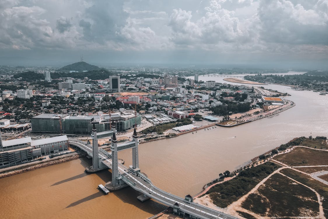
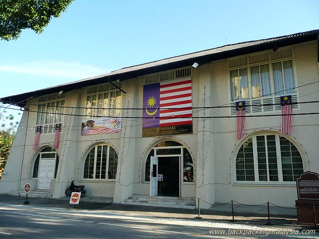
Colloquially known as KT, Kuala Terengganu is the administrative, economic, and royal capital of the state. It is also the only royal capital among the nine royal states of the country to bear its state’s name. Kuala Terengganu is located about 440 km northeast of Kuala Lumpur on the East Coast of Peninsular Malaysia. The city is situated at the estuary of the Terengganu River, facing the South China Sea. Kuala Terengganu was awarded city status as well as the title Bandaraya Warisan Pesisir Air or Waterfront Heritage City on 1 January 2008.

Kuala Terengganu continued to be Terengganu’s capital when it was still a vassal state of Siam and during the early years of the British colonisation of Malaya. Terengganu fell under the administration of Britain through the Bangkok Treaty of 1909 and was forced to accept a resident British advisor. Terengganu, along with four other states were grouped under the term of Unfederated Malay States. The British maintained its rule on Terengganu until the Japanese occupation in World War II. On 18 October 1943, Terengganu was annexed by Thailand as part of an agreement with the Japanese and after the war, the British regained control of Terengganu.

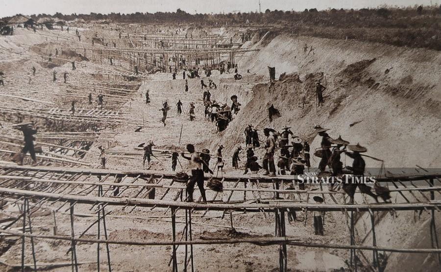
Kuala Terengganu was a major fishing port and one of the important trading ports in Malaya. The chief export commodities were coffee, gambier, gold, ivory, pepper, and tin. They were mainly traded for rice, tobacco, cotton goods and opium.

Kuala Terengganu’s economy is mostly made up of small-scale manufacturing industries such as traditional textile making, local food industries, arts and craft factories, and agriculture, with most of them centred around residential areas or villages. As the principal gateway for tourists to the state, tourism remains one of the economic sources for Kuala Terengganu.

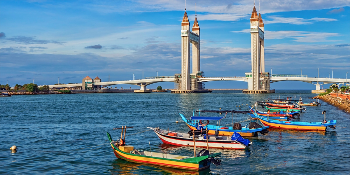
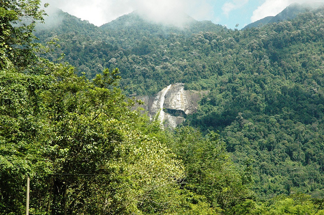
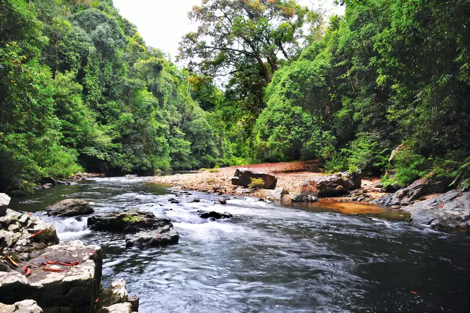
The Terengganu River is a beautiful river that originates from Lake Kenyir in Hulu Terengganu and flows through Kuala Terengganu, leading up to the South China Sea. This beautiful river has several bridges namely the Sultan Mahmud Bridge, the Manir Bridge, the Pulau Sekati Bridge, and the Kuala Terengganu Drawbridge. Several cruises also operate at the site which provides an enjoyable experience to visitors. A boat ride in this beautiful river will enable one to witness traditional fishing boats, traditional silt houses, as well as wonderful wildlife creatures.

A small hill known as Bukit Puteri can be found close to Pasar Payang. The hill is located near the banks of the Terengganu River and because of its strategic location, it was used as a fortification by the sultans of the state. Old artefacts, a graveyard, and monuments can be found on top of the hill. During the Islamic holy month of Ramadan, a century-old brass bell known as genta will be rung to signify that it is time for iftar or the end of the fasting on that day.

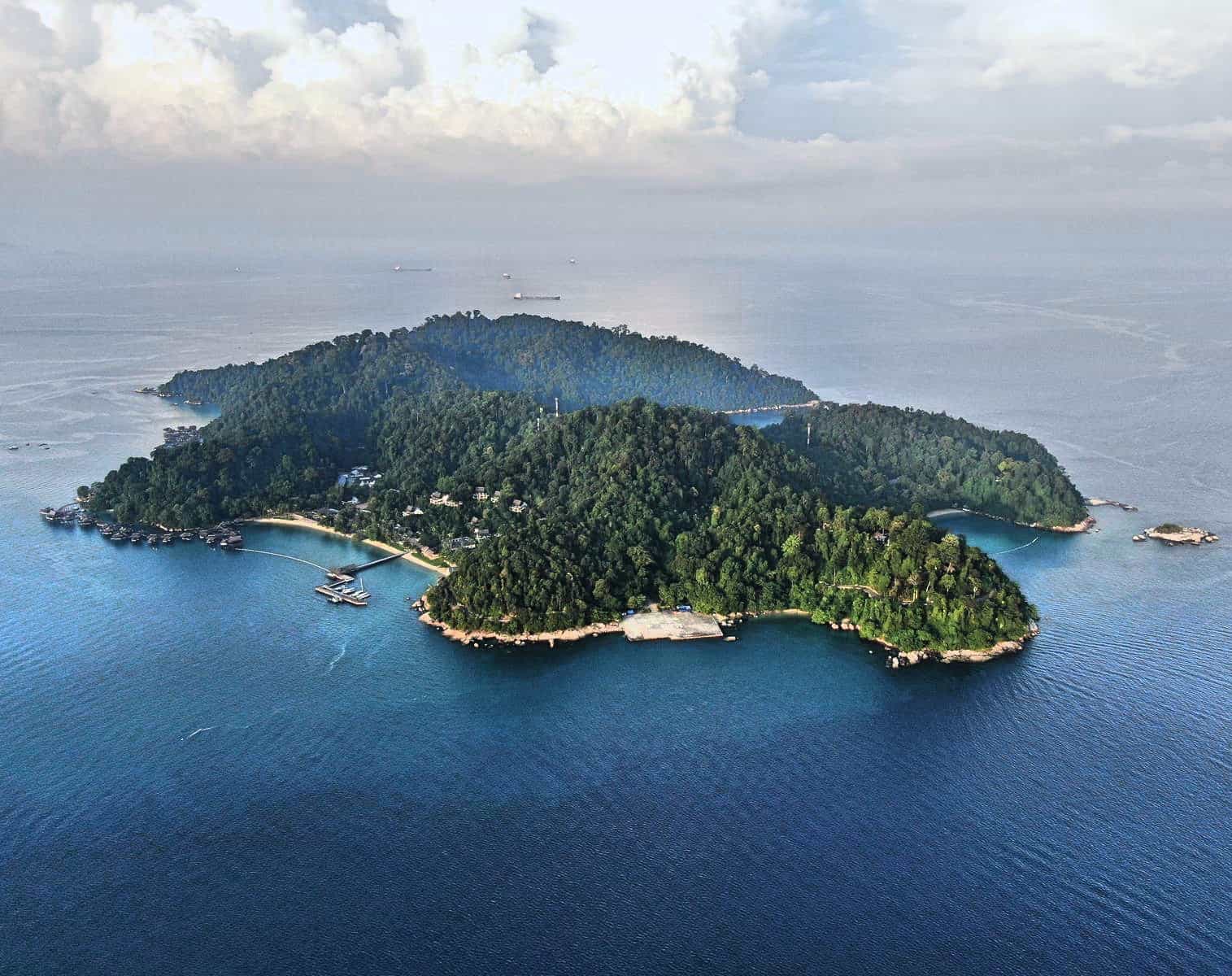
Pulau Duyong is a river island located at the Terengganu River estuary known for its traditional boat-making activities. Pulau Duyong also contains a historical monument known as Kota Lama Duyong or Duyong Old Fort, which is a traditional Malay house built with local and European elements. Rumah Warisan Haji Su or Haji Su Heritage House, a complex of two traditional Malay houses located in mukim Losong, is another historical and cultural attraction of the city.

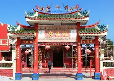
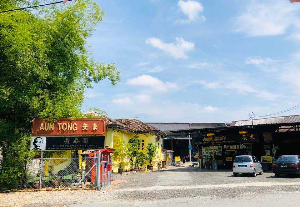
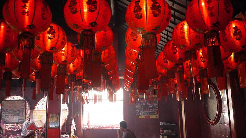
The Chinatown of Kuala Terengganu is the centre of the Peranakan Chinese in the city. One of the main tourist attractions of Kuala Terengganu, this settlement consists of two rows of shophouses from the prewar era, with some of them dating back to the 1700s. Most of the houses are 2 stories high, mainly made of bricks or concrete, with wooden flooring for the second storey. Some have kept the intricate wood carving windows, huge, heavy wooden front doors, and old plaques. The centuries-old buildings now consist of sundry shops, local coffee shops, offices, souvenir shops, restaurants, kopitiam, and other services. It is home to two Chinese temples, Ho Ann Kiong and Tien Hou Kong, which were built in 1801 and 1896. The Hoi Ann Temple houses a statue of Mazu, the Goddess of the Sea. Another landmark is the 19th-century Low Tiey water well, erected in 1875, which still supplies clean water to Chinatown’s residents. The recent attractions in Kampung China are its back alleys, many of which are transformed into thematic lanes containing various information, decorations, and murals. Turtle Alley is a beautiful back alley that portrays a lot of information about turtles, with turtle-themed walls and floor mosaics. Another thematic lane, the Tuake Wee Seng Hee Cultural Lane, is old-styled with a colonial-era telephone booth and a classic red cast iron post box, which is still used today. The walls of the lane are filled with a collection of old signs from shops in Chinatown and Han Dynasty-era poems. This is one of the most popular photography spots in Chinatown. Chinatown is popular for the various local delicacies such as roti paong, durian cake, Pulut Dipa and the white keropok lekor, which is made out of wolf herring or ikan parang.

The architecture in Chinatown shows influences of traditional Southern Chinese architecture along with neoclassical or Art Deco. The shophouses have distinguishing façades. While the older buildings have bland designs, the neoclassical buildings have a more ornate architecture. The shophouses were not made singularly, but rather connected with other shophouses to form a long structure, separated by numerous back alleys. They are mostly two-story buildings. Families using the shophouses for commercial purposes dedicate the ground floor to business and trade and live on the top floor. One of the most significant and common details of all these buildings is the covered passageway in front of the buildings, known as kaki lima or the five-foot way.

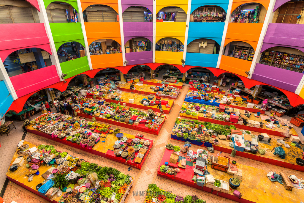
Bazaar Warisan contains vendors selling traditional fabrics such as batik and songket. The double-storeyed Pasar Besar Kedai Payang or Central Market, more commonly known as Pasar Payang is the main market of the city and houses different kinds of goods. One of Terengganu’s famous attractions, the market is located in the heart of Kuala Terengganu on the banks of the Terengganu River. The market building comprises two floors and can accommodate up to 1,000 traders. There is a great variety of products on display at the market, including those that depict the heritage of the stage and are thus sold in keeping with the Terengganu culture. The stalls on the ground floor sell wet goods as well as some delicious traditional cakes, in addition to selling grocery items. On the first floor, one will find shops selling copper products, songket fabrics, clothes, brocade, batik, and brassware, as well as a variety of bronze art items and accessories.

Malaysia’s first floating mosque, the Tengku Tengah Zaharah Mosque, is located near the banks of Kuala Ibai Lagoon, just 4 km from Kuala Terengganu. The 25-year-old mosque was built by the late Sultan of Terengganu in memory of his mother. Built in a Moorish architectural style, the mosque is made of shimmering white marble, along with Bomanite paving and mosaic work, and looks even more attractive during the night. While the main prayer hall is downstairs and allows only males to enter, the hall on the upper level allows females. Winning the Aga Khan Award for exceptional architecture in 1994, Tengku Tengah can accommodate 2000 attendees in its 5 acres of circumference. The pristine white 125-foot-tall minaret of the mosque against the peeping South China Sea on one side makes the Tengku Tengah Zaharah Mosque a major attraction. Non-Muslims are not permitted to enter during prayer hours.

Nestled in the Islamic Heritage Park, the Crystal Mosque is a unique and popular attraction. Constructed between 2006 and 2008, the mosque encompasses several modern architectural elements. The crystal mosque boasts four minarets that appear to radiate a golden hue during the daytime. The exterior is made up of glass, crystal, and steel, and the interiors are adorned with ginormous crystal chandeliers. The corridor is decorated with magnificent latticework, and the gorgeous yellow mihrab has calligraphy engraved on it. The mosque can accommodate up to 1500 people at any point in time. The mosque is open between 6 am and 11 pm.

The Abidin Mosque is the old state royal mosque whose history dates back to 1793. It was built by Sultan Zainal Abidin II and is also referred to as the Big Mosque or the White Mosque. Abidin Mosque boasts nine domes and intricately decorated latticed windows. The gigantic structure can accommodate up to 2500 people at any time. The old Royal Mausoleum is also situated nearby.

Ho Ann Kiong is the oldest Chinese temple in Chinatown, Kuala Terengganu. This beautiful temple is adorned with red and golden architectural elements and marvellous stone carvings. One can also admire the gigantic wishing tree that can be found behind the temple premises. The history of this temple dates back to 1801, when it was built by the early Hokkien community. Unfortunately, this temple was destroyed by fire in 2010 and fully restored in 2012. UNESCO has assigned heritage value to the temple.

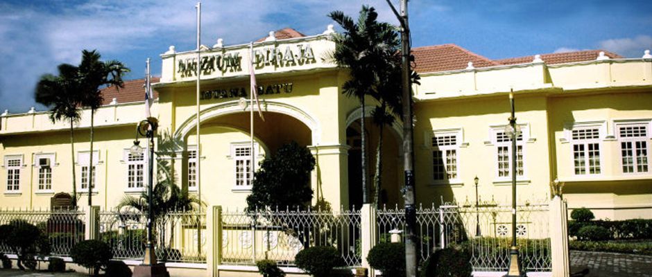
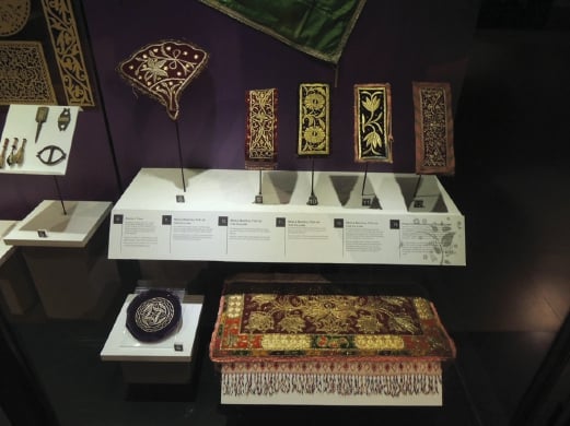
The Terengganu State Museum is one of the largest museum complexes in Malaysia and Southeast Asia, with an area of 75,000 sq m. The architecture is based on the traditional Terengganu Malay house known as rumah tele. It has eight different galleries across four buildings and other open-air exhibits such as the Petronas Gallery, the Maritime Gallery, the Islam Gallery, exhibits of traditional Terengganuese houses, and many others. The museum is also the home of the Terengganu Inscription Stone, the oldest artefact with Jawi writing in the country. This museum is adorned with concrete stilts, landscaped gardens, ponds, and beautiful roofs. Some of the other attractions of the museum include the rumah tele gifted by King Mongkut of Thailand, the Batu Bersurat inscription stone, traditional weapons, Islamic artistic elements, and traditional real houses. The museum is open from 9 a.m. to 5 p.m. on Saturdays and Thursdays, from 9 a.m. to 12 noon and then from 3 p.m. to 5 p.m. on Fridays. Entry fees for Malaysians are RM 5 for adults, RM 2 for children and RM 1 for students in uniform. For foreigners, it is RM 15 for adults and RM 10 for children.

The Batu Bersurat, Batu Bersurat Terengganu or the inscribed stone of Terengganu can be found in the Terengganu State Museum. This stone provides one of the oldest pieces of evidence of Jawi writing, which is the Arabic alphabet used in Malaysia. The stone was found near the Teluk Gedong waterfront and was listed as a United Nations Memory of the World.

To date, the stone’s replica can be found in Kampung Buluh, Kuala Berang and Ladang Roundabout in Kuala Terengganu. Its inscriptions prove that Islam was the state religion. The stone rises to a height of about 89 cm and weighs about 214.8 kg. The Batu Bersurat bears 3 facades and its four sides bear inscriptions in opposite directions. While the inscriptions talk about the spread of Islamic culture, they also provide insight into the lives of Malaysian people during the 10th and 11th centuries. A proclamation by the ruler of Terengganu can also be found in the Batu Bersurat. In this proclamation, the ruler urges his subjects to uphold Islam and he also states the 10 basic Sharia laws. A symbol of the Dutch East India Company is also carved on the stone. Information about regional trade is also inscribed on it. Further, it also bears the depiction of a tiger that appears to be stealing a child. The Batu Bersurat stone was found in Terengganu, Malaysia. It was founded by the locals during a flash flood and taken to a mosque, where it was used as a platform for ablutions. Here, it was discovered by Syed Hussin, who took the stone to the Sultan of Terengganu to obtain more information about it.

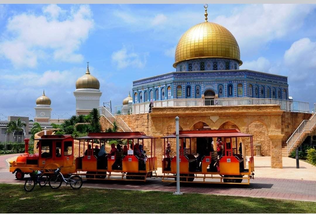
Taman Tamadun Islam or the Islamic Heritage Park, was opened in 2008 and is located on Wan Man Island. The star attraction is the congregation of various Islamic historical monuments from around the world. There are several offers and packages of attractions bundled together that enable visitors to get the maximum value for their money. There is a river cruise that operates from 10 am to 6 pm on Mondays, Wednesdays and Thursdays, and from 9 am to 6 pm on Fridays, Saturdays, Sundays and selected holidays. Monument Park and the Taman Tamadun Islam River Cruise remain closed on Tuesdays except for school and selected public holidays. The Friday prayer break timing is from 11:30 am to 2:30 pm. Entry fees are RM 20 for adults and RM !5 for children between seven and twelve. For Monument Park, the entry fees are RM 24.10 for adults and RM 17.80 for children between 7 and 12. The public park is open to all, free of charge. There are 22 replicas of world-famous mosques, architectural structures and monuments of Islamic influence and importance, like India’s Taj Mahal, Saudi Arabia’s Masjidil Haram and Egypt’s Alabaster Mosque, to name a few. It is also lit up in the evening with a splendid light show.

Travel Bucket List: Malaysia Part 29 – Terengganu Part 1

Located in eastern Peninsular Malaysia, Terengganu is bordered in the northwest by Kelantan, in the southwest by Pahang, and in the east by the South China Sea. Several outlying islands, including the Perhentians, Kapas and Redang, are also part of the state. The state is also known by its Arabic honorific, Darul Iman or Abode of Faith. Terengganu is geographically divided into sparsely populated and mountainous inland known as the Terengganu Highlands and largely flat coastal plains, in which most of the state’s people are concentrated. The state is known for having the longest coastline in west Malaysia and many of the most popular islands in Malaysia are located in the state of Terengganu.

The coastal city of Kuala Terengganu, which stands at the mouth of the broad Terengganu River, is both the state and royal capital as well as the largest city in Terengganu. Other major cities and towns include Jerteh, Kuala Dungun, Chukai, Kuala Berang, Marang, and Permaisuri. Terengganu is Malaysia’s 7th-largest state by area and 10th-largest in population. Terengganu, along with Kelantan, Perlis and the Federal Territory of Putrajaya, is one of the most homogeneous states and territories in the country, of which 95% of the population are ethnic Malay-Muslims with their distinct language, dialect, culture, history, and tradition.

In Malay, kuala can mean river mouth, estuary, or confluence. Thus, Kuala Terengganu is roughly translated as the confluence or estuary of Terengganu, referring to the broad expanse of the Terengganu River estuary, which empties into the South China Sea. There are several theories regarding the name Terengganu. One theory attributes the name’s origin to terang ganu, Malay for bright rainbow. Another story, considered to be the most popular version, is said to have been originally narrated by the ninth Sultan of Terengganu, Baginda Omar. It tells of a party of hunters from Pahang roving and hunting in what is now southern Terengganu. One of the hunters spotted a big animal fang lying on the ground. A fellow party member asked to which animal the fang belonged. The hunter, not knowing which animal, simply answered taring anu, Malay for fang of something. The party later returned to Pahang with a rich hoard of game, fur, and sandalwood, which impressed their neighbours. They asked the hunters where they sourced their riches, to which they replied, from the land of Taring Anu, which later evolved into Terengganu. Terengganu was called Trangkanu by the Siamese when it was under their influence. Terengganuans usually pronounce Terengganu as Tranung or Ganu, with the G often being emphasized.

The traditional Chinese name for Terengganu has been Dīngjiānú, which is a direct transcription of the Malay name. However, in recent years, the Chinese community in Terengganu has raised objections to the name, citing that the characters used loosely translate to giving birth to a child who will become a slave. They successfully petitioned the regulatory commission for the Chinese language in Malaysia to change the Chinese name for the state to Dēngjiālóu, which can be loosely translated to aspiring or stepping up to a higher level, in September 2004. The new name was in unofficial use by the state’s Chinese community for at least 30 years before its official adoption.

Human activities may have already existed in Terengganu as early as 16,000 years ago, during the Paleolithic age, as evidenced by the discovery of a skeleton in Gua Bewah, Hulu Terengganu, in 2009. The skeleton, which is called Bewah Man, has been analysed as 5,000 years older than skeletons found in Perak, making it the oldest known modern human skeleton in the country.

Terengganu’s location by the South China Sea ensured that it had been on trade routes since ancient times. Based on Ptolemy’s 2nd-century map called Golden Chersonese, the areas of what would be known as Terengganu today were historically called Perimula and Kole Polis. The earliest written reports on the area that mentioned the name Terengganu were by Chinese merchants and seafarers in the early 6th century A.D. During the early Hindu-Buddhist period, Terengganu was known as Tan-Tan, which is based on what is now Kuala Telemong. It was a small ancient polity that came under the influence of Langkasuka, a powerful kingdom based either in Kedah or Patani in the 1st century AD. In the 7th century, the dynasty of Langkasuka that once ruled over Terengganu was replaced by a new kingdom called Srivijaya, under whom Terengganu traded extensively with other kingdoms in the Malay Peninsula, Borneo and Sumatra, Champa, the Khmer Empire, the Majapahit Empire and especially the Chinese.

The present Sultanate of Terengganu was established in 1708. The first Sultan of Terengganu, Sultan Zainal Abidin I, established his court near Kuala Berang, then moved his court a few more times until he settled near Bukit Keledang, Kuala Terengganu. During the early 18th century, Kuala Terengganu was still a small town. It was described as having about one thousand houses that were scattered around the town. The Chinese were already present in Kuala Terengganu at that time. Half of the population were Chinese, and they were engaged in agriculture and trading. After the death of Sultan Daud in 1831, a brief civil war erupted between two claimants to the throne, namely Tengku Mansur and Tengku Omar. Tengku Omar was based at Bukit Puteri, while Tengku Mansur was based at Balik Bukit. Tengku Omar was defeated by Tengku Mansur, and he fled from Terengganu. Tengku Mansur became the next Sultan as Sultan Mansur II. His son, Sultan Muhammad, succeeded him as the next Sultan after his death in 1837. However, in 1839, Tengku Omar returned to Terengganu with his entourage to reclaim the throne. He defeated Sultan Muhammad and forced Sultan Muhammad to flee. Tengku Omar reoccupied his fort at Bukit Puteri and was throned as the next Sultan, Sultan Omar.

Terengganu was the first Malay state to receive Islam, as attested to by the Terengganu Inscription Stone with Arabic inscriptions found in Kuala Berang. The inscribed date, which is incomplete due to damage, can be read as various dates from 702 to 789 AH (1303 to 1387 CE). Terengganu became a vassal state of Malacca but retained considerable autonomy with the emergence of the Johor Sultanate.

Terengganu emerged as an independent sultanate in 1724. The first sultan was Tun Zainal Abidin, the younger brother of a former sultan of Johor, and Johor strongly influenced Terengganu politics through the 18th century. In the 19th century, Terengganu became a vassal state of the Thai Rattanakosin Kingdom and sent tribute every year called bunga mas. Terengganu prospered and was largely left alone by the authorities in Bangkok, unlike in neighbouring Patani and Kelantan. The period also witnessed the existence of a Terengganuan vassal, Besut Darul Iman.

The terms of the Anglo-Siamese Treaty of 1909 saw power over Terengganu transferred from Siam to Great Britain. A British advisor was appointed to the sultan in 1919, and Terengganu became one of the Unfederated Malay States. The move was highly unpopular locally, and in 1928, the British used military force to suppress a popular uprising.

During World War II, Japan occupied Terengganu and transferred sovereignty over the state back to Siam, which had been renamed Thailand in 1939, along with Kelantan, Kedah, and Perlis. After the defeat of Japan, British control over these Malay states was reestablished. Terengganu became a member of the Federation of Malaya in 1948, then a state of a sovereign Malaya in 1957, which became Malaysia in 1963. Following decades of rule by the Barisan Nasional coalition, the Pan-Malaysian Islamic Party (PAS) came to power in 1999, making Terengganu the second state in Malaysia to be ruled by the Islamist party, the first being neighbouring Kelantan.

Terengganu used to be Malaysia’s poorest state until oil and gas were discovered off its coastline in the 1980s, and the state’s main industry now is petroleum and gas. Tourism and fishing are also major industries and agriculture also remains important. Terengganu was traditionally famous for boatbuilding, with highly decorated, carved wooden boats called bangau to be found in the harbour of every village and town. The state did not receive many Indian or Chinese migrants, and therefore Malay cultural influences predominate. Traditional pursuits such as kite-flying contests, top-spinning contests, and traditional arts and crafts such as batik and songket are still very much alive.

Terengganu, along with Kelantan, is known as the cradle of the Malay civilization in Peninsular Malaysia. There are various traditional dances in the state, such as the Ulek Mayang, Rodat, Saba, Balai, and Nur Sakti; some even predate the arrival of Islam in the region. Terengganu is also one of few states to adopt the gamelan as part of their traditional theatre, after Riau and Pahang; the Terengganu gamelan has developed a distinct identity from the Sundanese and Javanese gamelan. The gamelan was originally brought to Pahang and later to Terengganu and was played only during royal occasions. Today, the gamelan is part of the state’s cultural heritage.

Travel Bucket List: Malaysia Part 28 – Kelantan Part 2

Continuing our exploration of Kelantan

The architecture of the Sultan Ismail Petra Silver Jubilee Mosque is unique because it combines Chinese and Islamic architecture and resembles the 1,000-year-old Niujie Mosque in Beijing. Construction on the mosque started on September 12, 2005, and the mosque was inaugurated in August 2009 and boasts an area of 3.7 acres and can accommodate 1,000 worshipers at one time. The mosque’s interiors are a fascinating mixture of Chinese, Islamic, Indian, and Uzbek styles of architecture and elements. It has a towering minaret where one can see the names of all 25 Prophets inscribed on tiles. The mosque is open to people of all faiths except during prayer time.

The Muhammadi Mosque was built as a tribute to the late Sultan Muhammad IV’s contribution and service to the state. Masjid Al-Ismaili is a significant and beautiful mosque. It is said that this mosque was a gift to Sultan Ismail Petra from his son, Sultan Muhammad Ⅴ. That’s why it is a great testimony to father-son bonding. The mosque has five minarets and a five-step staircase leading to the entrance, and the number five symbolizes the five pillars of Islam. At the same time, it has six domes, symbolizing six pillars of faith. The mosque is open to people of all faiths during non-prayer times.

The Wat Photivihan Sleeping Buddha is one of the 25 temples found in Tumpat and one of the most popular in the country. Also called the Phothivihan Buddhist Temple or Wat Yamu, the temple was established in 1973 by Abbot Phra Krurasapia Chakorn and attracts thousands of Thai pilgrims every year. The temple houses a 40-metre statue of the sleeping Buddha, considered the largest and longest in the state since its construction in 1975. Upon its completion in 1979, the statue was recognised as one of the two reclining Buddha statues in Malaysia and also the largest in Southeast Asia, until it was surpassed by the 66-metre statue in Chaukhtatgyi Buddha Temple in Myanmar. Devotees of this temple are mainly ethnic Thais since the temple itself is a typical Thai Buddhist temple of Theravada Buddhism. There is also a Chinese Pavilion, a Tibetan-style hall featuring a statue of the Bodhisattva Avalokitesvara with 18 arms and Phra Phrom, the four-faced goddess. The compound also includes accommodation for monks and visitors. There is plenty of free parking and entrance to the temple is free. Any donations from visitors are always welcome.

Wat Machimmaram Temple is an amazing Thai Buddhist temple located in Tumpat with a 30-meter-high sitting Buddhist statue. The temple’s architecture is a mixture of Chinese and Thai styles, with guardian deity statues in Chinese style. There is a turtle pool and many food and drink stalls. Wat Maisuwankiri, near the village of Kampung Bukit Tanah, boasts a floating temple and a richly decorated dragon boat surrounded by a murky moat. At Wat Pikulthong, on the apex of a mound of earth, this gold mosaic standing Buddha shimmers under a tropical sun. Wat Kok Seraya features a golden stupa and a statue of a standing female Buddha.

The Seng Choon Kiong, also known as Mazu Temple, is an approximately 300-year-old temple in Kampung Tok’kong and is a site of pilgrimage for worshippers of Mazu in Malaysia. The Water and Moon Temple is a must-visit because it has a history spanning more than 500 years. The temple’s statues are nearly 600 years old. It is locally believed that the temple grants the wishes of the needy. Zi Xia Dong, or Princess Cave, is a Chinese cave temple that is located just opposite the Water and Moon Temple. To reach the temple, one must cross the metal bridge, a pebbled path, and a rubber plantation before climbing up a 20-meter-high staircase to reach the peak of the limestone hill. Inside the cave is a giant figure of the Goddess of Mercy, which is worshipped. There are many stories about this cave. One story is that there was a princess who was ferrying a ship through this land with her father and other crew members. When the ship arrived here, the Princess fell in love with the Pulai settlement, and she was reluctant to go back with her father. So to escape from her father, she hid in the cave and gradually became the guardian of the hill.

The town of Gua Musang is famous for its limestone hills and caves. The name Gua Musang means Cave of the Fox. One can explore numerous caves here, including Gua Musang, Princess Cave, Gua Batu Hijau, Bombed Cave, and many more. One should take enough precautions while climbing and exploring these caves, as some of them are filled with insects and bats. Gua Ikan is one of the most commonly visited caves in Kelantan. It is very famous because the cave’s rock formation resembles a fish shape, which is why it earned the name Fish Cave. Due to the complexity of the cave’s geology, it is recommended to hire a guide from the nearby Gunung Stong State Park. The cave is made of limestone and hosts animals like bats, whip scorpions, spiders, and lots of mosquitos. The caves are open between 8 am and 5 pm daily. Close to Dabong, this cave features a limestone grotto carved out by a flowing river that can rise rapidly and dangerously after rain. Usually, however, it is a pleasant, if slightly overused, picnic spot.

Gunung Stong State Park is home to one of the highest waterfalls in Malaysia, the seven-tiered Jelawang Waterfall. Named for the 1422 m-high Gunung Stong mountain, this 219.5 sq km park, only 15km from Dabong, features beautiful stepped waterfalls and offers amazing hiking, swimming and trekking. It is believed to be home to elephants, tigers and tapirs. The beauty of Jelawang Waterfall can be seen from a distance as one travels towards the park entrance. From the park, you can hire a guide to lead you, or you can hike yourself, following the trails given.

Located in the Gua Musang Region near Kelantan’s borders with Pahang and Terengganu, Taman Negara is located in the Hantu Hill and Lebir Reserve forests. Also known as Kuala Koh National Park, because it is located across three states, visitors sometimes get confused about which state the national park is located in. In truth, the park is located in the district of Gua Musang in Kelantan State. The park is mostly tropical rainforest and is home to Malaysia’s highest mountain, Mount Tahan. There are a vast number of exotic birds, animals, insects, and even reptiles and amphibians. The park is open from 9 a.m. to 5:30 p.m. on Mondays and Saturdays and from 9:30 a.m. to 5:30 p.m. on Sundays. Taman Tasik Gua Musang is a relaxing and beautiful lake garden where one can enjoy walking, jogging, and exercising.

Named after Prophet Muhammad’s entrepreneurial wife, Siti Khadijah Market is a fitting name for a market mostly run by women. The market was originally established as Buluh Kubu Market in 1985 and opened to the public by Sultan Ismail Petra. The market was then renamed Kelantan Menteri Besar Nik Abdul Aziz Nik Mat in 1997. The market is housed in a four-story building and features an octagonal shape. Fresh goodies, ready-to-eat foods, local snacks and drinks can be found in the market. The bottom floor is dedicated to wet items such as fish, vegetables, chicken and so on. Level 1 is allocated to dry food items such as serundeng. They additionally sell traditional Kelantan cakes, chicken, spiked fish, rice noodles, glazed rice, nasi dagang, laksam and somtam. The second and third floors are for non-food items.

Also known as Balai Getam Guri, the Handicraft Village and Craft Museum houses many fine examples of Kelantanese craftsmanship such as traditional embroidery, songket weaving, batik printing, silver work and wood carving. Kampung Kraftangan is a handicraft market, a touristy affair opposite Istana Batu, with a one-room museum with displays of woodcarving, batik-making and other crafts.

The pale-yellow Istana Batu building, constructed in 1939, was the crown prince’s palace until it was donated to the state. Now a museum, the richly furnished rooms give a surprisingly intimate insight into royal life, with family photos and personal belongings scattered among the fine china, chintzy sofas and the late sultan’s collection of hats.

The Bank Kerapu War Museum was the Japanese headquarters during their occupation during WWII. Before that, this building was the first trading bank in Kelantan. This museum displays more than 1000 exhibits relating to war such as Japanese tools that were used during the occupation. It is open from 8:30 am to 4:45 pm daily except Fridays.

Next to the tourist information centre, the Muzium Negeri Kelantan is the official state museum. The exhibits on Kelantan’s history and culture are interesting, but the accompanying signage can be poor. Muzium Islam occupies an old villa once known as Serambi Mekah or Verandah to Mecca, a reference to its days as Kelantan’s first school of Islamic instruction. Nowadays, it displays a small collection of photographs and artefacts relating to the history of Islam in the state.

Istana Jahar, Kota Bharu’s best museum, focuses on Kelantanese rituals and crafts. It’s housed in a beautiful chocolate-brown building that dates back to 1887 and is easily one of the most attractive traditional buildings in the city. The collection here includes detailed descriptions of batik weaving, the elaborate ceremonies of coming-of-age circumcision, wedding nights and funerary rights. It is known as Jahar because of a tree that grew on the palace grounds. The museum is open from 8:30 am to 4:45 pm on all days except Fridays. For locals, adults need to pay RM 2 and children pay RM 1, while foreign adults will pay RM 4 and children will pay RM 2.

The Jungle Railway is a must-see attraction of Kota Bharu. The railway runs along the east coast and through the centre of Malaysia and passes through Kelantan, where it stops at the city of Tumpat. It is described as one of the world’s most picturesque journeys. Throughout the journey, one can get to see the luxurious green jungle with the best scenery of the journey once it heads north. While travelling from Kuala Lipis to Kuala Krai, one can see huge rivers and limestone hills around the town of Gua Musang. And that, according to tourists, holds the best scenery of the entire journey. To travel from Tumpat to Kuala Lumpur, a first-class ticket will cost between RM 101 and RM 130 and a second-class ticket will be about RM 31 per person.

This is all that I could find about the state of Kelantan. I believe that this state is very underrated and has a lot of potential for tourism. Let’s see when I can make it here. Keep watching this space for the next state we will be exploring, the state of Terengganu.

Travel Bucket List: Malaysia Part 27 – Kelantan Part 1

Located in the northeastern corner of the Malay Peninsula, Kelantan is said to translate as the Land of Lightning. An agrarian state with green paddy fields, rustic fishing villages and casuarina-lined beaches, Kelantan is home to some of the most ancient archaeological discoveries in Malaysia, including several prehistoric aboriginal settlements. The honorific name of the state is Darul Naim or the Blissful Abode. Kelantan is the only state outside of East Malaysia that does not use the term district in its second-level administrative division. Instead, the districts are named as colonies (Jajahan), or collectivities and one autonomous subdistrict. The capital, Kota Bharu, includes the royal seat of Kubang Kerian.

Kelantan is bordered by Narathiwat Province of Thailand to the north, Terengganu to the southeast, Perak to the west and Pahang to the south. To the north-east of Kelantan is the South China Sea. Due to Kelantan’s relative isolation and largely rural lifestyle, Kelantanese culture differs somewhat from Malay culture in the rest of the peninsula; this is reflected in the cuisine, arts and the unique Kelantanese Malay language, which is unintelligible even for some speakers of standard Malay.

Kelantan has diverse tropical rainforests and an equatorial climate. The state’s mountain ranges belong to the Titiwangsa Mountains, which are part of the Tenasserim Hills that span throughout southern Myanmar, southern Thailand and Peninsular Malaysia, with Mount Yong Belar being the state’s highest point.

There are several suggestions for the origin of the name Kelantan. One theory proposes that the word Kelantan comes from a modified version of the word gelam hutam, the Malay word for the cajuput, or swamp tea tree. Other theories claim that the name comes from the Malay word kilatan, which translates to shiny or glittery or kolam tanah, which means a clay pool. Kelantan was called Kalantan by the Siamese when it was under their influence.

Kelantan’s early history is not very clear, but archaeological evidence shows human settlement in prehistoric times. Early Kelantan had links to the Funan Kingdom, the Khmer Empire, Sri Vijaya, Majapahit and Siam. Around 1411, Raja Kumar, the ruler of Kelantan, became independent of Siam, and Kelantan became an important centre of trade by the end of the 15th century.

In 1499, Kelantan became a vassal state of the Malacca Sultanate. With the fall of Malacca in 1511, Kelantan was divided up and ruled by petty chieftains, paying tribute to Patani, then a powerful Malay kingdom of the eastern peninsula. By the early 17th century, most of these Kelantan chiefs had become subject to Patani. Kelantan made a political alliance with Patani during the reign of Raja Biru in 1619 for mutual trade and military interests. The Queen of Patani was deposed in 1651 by the Raja of Kelantan, starting a period of Kelantanese rule in Patani.

Around 1760, Long Yunus, an aristocratic warlord of Patani origin, succeeded in unifying the territory of present-day Kelantan and was enthroned by his father-in-law, Ku Tanang Wangsa, the Regent of Terengganu, as Yang di-Pertuan Muda or Deputy Ruler of Kelantan. Long Yunus was succeeded in 1795 by his son-in-law, Tengku Muhammad, by Sultan Mansur of Terengganu. The enthronement of Tengku Muhammad by Terengganu was opposed by Long Yunus’ sons, thus triggering a war against Terengganu by Long Muhammad, the eldest son of Long Yunus. The pro-Terengganu faction was defeated in 1800 and Long Muhammad ruled Kelantan with the new title of Sultan as Sultan Muhammad I. Later, when the new sultan died childless, it triggered another civil war among claimants to the throne. His nephew, Long Senik Mulut Merah, triumphed over his uncles and cousins and assumed the throne in 1835 as Sultan Muhammad II. Sultan Muhammad II leveraged his loose alliance with Siam to form the modern Kelantan state, centred in his new fort on the eastern bank of the Kelantan River, which became Kota Bharu in 1844.

Under the terms of the Anglo-Siamese Treaty of 1909, the Thais relinquished their claims over Kelantan, Terengganu, Kedah and Perlis to the British Empire, and Kelantan thus became one of the Unfederated Malay States with a British adviser. Kelantan was where the Japanese first landed during their invasion of Malaya, on December 8, 1941. In 1943, Kelantan was transferred by the Japanese to Thailand during World War II and became a province of Thailand. Kelantan reverted to Malaya upon the end of World War 2 in August 1945.

Kelantan became part of the Malayan Union in 1946 and then the Federation of Malaya on February 1, 1948, and together with other Malayan states, it attained independence on August 31, 1957. On September 16, 1963, Kelantan became one of the states of Malaysia.

From Kuala Krai, the conjoined streams become the Kelantan River, also known as Sungai Kelantan, a broad, mud-coloured stream that dominates the fertile coastal plains and defines the geography of the region. The Kelantan River valley is a fertile rice bowl, rich in hardwoods and rubber and lush with tropical fruits.

For centuries, Kelantan was all but separated from the rest of the country by the Titiwangsa Mountains, a mountain range running from north to south through the peninsula. Weeks of hard travel were required to reach Kelantan. The easy way to Kelantan was to sail around the peninsula, braving the sea and pirates. For this reason, Kelantan’s history often involves the sea and boats. Even today, many of its people are very much tied to the sea. A discussion with many coastal residents will confirm that their ancestors, as far back as they know, were of the sea.

During the 1920s, in the days of British colonial rule, a railway line was built, linking Tumpat on the state’s northern coast, through the jungles of upper Kelantan and Pahang and then on to other states. Also, between the 1920s and 1980s, trunk roads were built to link Kelantan with adjacent states.

Kelantan has a chiefly agrarian economy dominated by rice, rubber and tobacco. Fishing along its 96-kilometer coastline is also an important economic activity. Cottage industries that employ traditional skills in handicraft production, such as batik, woodcarving and songket weaving, are also evident. Logging activities are active, given the vast remaining area of forest. In recent years, tourism, especially to offshore islands, has increased in importance. Kelantan’s GDP is significantly lower than that of any other state in Malaysia.

Kota Bharu, the capital, is the major urban centre, and there are also plans to open up the southern portion of the state under an ambitious multimillion-dollar development project. The main market in the city centre is a top attraction.

Colloquially referred to as KB, Kota Bharu serves as the state capital and royal seat of Kelantan. It is situated in the northeastern part of Peninsular Malaysia and lies near the mouth of the Kelantan River. The town is home to many religious buildings and museums. The unique architecture of the old royal palaces is still occupied by the sultan and sultanah and is off-limits to visitors but viewable from the outside.

Kota Bharu means the new city or new castle or fort in Malay. Occasionally, the name of the city is written as Kota Baharu. Kota Bharu was founded during the late 19th century. Before its establishment, Kota Bharu was home to Kelantan’s Royal Palace, then established by Sultan Muhammad II of Kelantan in 1844 as Kelantan’s state capital who wanted the new state capital built in his honour. Before this, Kota Bharu was known as Kuala Kelantan. Before Kota Bharu assumed the role, the Kelantanese capital was divided into two which were Kota Kubang Labu and Kota Pengkalan Datu. During the 19th century, Kelantan was a prosperous and populous state with a population of around 30,000 to 50,000 people including a thousand Chinese. Production from within the state included gold, tin ore, black pepper, areca nut, rice, rattan, bamboo, agarwood and songket. Kota Bharu acts as an entrepot for goods due to its strategic location beside the Kelantan River.

During World War II, Pantai Sabak, about 10 km from Kota Bharu, was the initial landing point of the Japanese invasion forces on 8 December 1941, which began the Battle of Kota Bharu, the first battle of the Malayan campaign. Japanese forces captured the city and would go on to successfully engage the British in jungle warfare and ultimately capture Singapore.

The city was declared a Cultural City on 25 July 1991 by the late Sultan Ismail Petra based on two important aspects – the history of Kota Bharu and the uniqueness of its local arts and cultures. Kota Bharu was rebranded as the Islamic City, Bandar Raya Islam in Malay, by the Kelantan State Government on 1 October 2005 through its Developing With Islam or Membangun Bersama Islam policy.

Diving in Kota Bharu is a relatively new activity. At present, only one dive shop operates in the area. Trips out to the wreck of the IJN Awazisan Maru, known locally as the Japanese Invasion Wreck are among the sites offered. This Japanese transport ship was the very first vessel to sink in the Pacific War. The wreck is a 30-minute boat journey from a jetty which is 10 minutes outside of Kota Bharu. Strong surf threatens all major beaches in the vicinity of Kota Bharu with substantial erosion. The community has been implementing wavebreakers by piling up massive amounts of boulders to protect the coastline. Regular beach activity has become impossible as visitors frequent beaches further south. In terms of tourism, the most famous beach in Kota Bharu is Pantai Cahaya Bulan. Once known as Pantai Cinta Berahi or the Beach of Passionate Love, today it is known as Pantai Cahaya Bulan or Moonlight Beach in keeping with Islamic sensibilities. Locally known as PCB, erosion events have seen the installation of a concrete breakwater, but PCB’s sandy sprawl is still worth considering for a seafood lunch. The road leading to PCB is quite pretty, especially by bicycle, and there are batik shops and workshops along the way. The Irama Bachok Beach is located within the Bachok District and is the main tourist spot for Bachok District residents and Kelantan residents in particular. The Pantai Bisikan Bayu or the Beach of Whispering Breeze is also known as Pantai Dalam Rhu. The gentle breeze at the beach produces a hushed sound that, locals say, sounds like a soothing whisper.

Travel Bucket List: Malaysia Part 26 – Perak Part 4

Taiping
Located approximately 48 km northwest of Ipoh, Taiping is the second largest town in Perak after Ipoh, the state capital. Taiping took over Kuala Kangsar’s role as the state capital from 1876 to 1937 but was then replaced by Ipoh. Its growth slowed after that, but in recent years,
the town has been developing rapidly again. Perak State Museum is located in the town.

Taiping is also known as Peninsular Malaysia’s wettest town, receiving an average rainfall of about 4,000mm in Taiping, while the peninsula’s average is 2,000mm–2,500mm. Its unusual rainfall has also led to a fertile collection of flora and century-old rain trees in the Taiping Lake Gardens.

The area developed quickly in the 19th century, when tin was discovered. The mines attracted large numbers of settlers, particularly Chinese. Feuds began between the different groups of Chinese immigrants and became so bitter that, in the early 1870s, the British intervened and assumed control of the town. Before 1937, Taiping was the state capital and the centre of a long and drawn-out war resulting in a change of rulership for the state. Taiping used to be known as Klian Pauh – Klian meaning mine while Pauh is a type of small mango.

Long Jaafar has been historically credited with the discovery of tin in Larut in 1848. According to legend, Long Jaafar had an elephant named Larut and he used to take this elephant with him when journeying between Bukit Gantang and Lubok Merbau. One day the elephant went missing and when the elephant was eventually found three days later Long Jaafar noticed tin ore embedded in the mud that was on the elephant’s legs. It is said that this was how Larut got its name. Eventually, in 1850, Larut district was bestowed upon Long Jaafar by Raja Muda Ngah Ali and the Chiefs of Perak. Sometime later, the Sultan of Perak, Sultan Abdullah, died in 1857 and a series of succession disputes ensued. Unhappy with the abuse and favouritism of various royalties, rival Malay camps took sides with one or the other of the two great Chinese secret societies present at the time.

Long Jaafar established and developed his administrative centre at Bukit Gantang and made Kuala Sungai Limau at Trong the principal harbour of the Larut Settlement. In 1857 Long Jaafar was succeeded by his son Ngah Ibrahim. In the time of Ngah Ibrahim, the Chinese increased in number and by early 1860 two large groups were formed by the Chinese, the Five Associations whose members worked in the mines of Klian Pauh and the Four Associations whose members worked in the mines of Klian Baharu.

The capital of Perak was moved from Bandar Baru or New Town to Taiping after Datok Maharaja Lela assassinated the first British Resident of Perak Mr. James Wheeler Woodford Birch at Pasir Salak in 1875. In 1937, the capital of Perak was moved from Taiping to Ipoh.

The town’s mining industry continued to thrive; the country’s first railway was built to transport tin from Taiping to Port Weld, now known as Kuala Sepetang at the coast for export. The first train in Malaysia took its schedule on 1 June 1885. By 1900, an English language school, a newspaper, and the Perak Museum, the oldest in Malaysia had been established. Although Taiping’s economy declined with the dwindling tin deposits, tin mining remains an important industry in the area as is rubber and rice.

One of Taiping’s most famous attractions, the 64-hectare Taiping Lake Gardens is created on the site of an abandoned tine mine. Taiping’s first public garden was established during British rule in Malaysia, the garden is located near Bukit Larut and is equidistant to the town centre and the Taiping Zoo. Home to 10 man-made lakes and ponds, it is visited for its aesthetics and beauty and is a sight to behold during sunrise and sunset. The gardens are also home to the gigantic Rain Trees. The place is lit with tall bamboo, pines and other trees like Angsena and Hujan that are scattered all over.

There are few private and government houses located near the gardens; among them are the Old Residency, home of the Secretary to the Resident, the Raja’s House at the junction of Birch Road and Residency Road and the army officers’ residences on Batu Tugoh Road.

Popularly known as Kolam Renang Batu Besar, the Burmese Pool is a large rock pool along a stream. This rock pool is quite spacious but shallow. Burmese Pool is named after the natural rock pool fed by a waterfall, which continues from there as Sungai Larut. Since this pool is located in the rainforest, visitors are required to go through the Taiping Lake Gardens and search for the signboard pointing towards the Burmese Pool. Burmese Pool is a favourite local picnic spot and is open between 8 am and 5 pm every day. There is a parking fee of RM 2 per entry.

Located in Changkat Jering, Trong Hotsprings is part of three pools whose access is permitted to those who opt for the RM 10 package. It is open from midnight to noon and then between 4 pm and midnight. Entry fees are RM 2 to soak in hot spring water which can be changed up to three times and RM 10 for access to all three pools.

Taiping Zoo, also known as the Taman Mergastua Sultan Idris Shah enjoys a scenic location at the Taiping Lake Gardens and is positioned right at the foot of the Maxwell or Larut Hill. Dwelling over a vast area of 34 acres, this wildlife park is currently home to more than 2000 animals which includes 180 indigenous and exotic species of amphibians, mammals, and reptiles. There is a sizable African Savannah as well as the Australian exhibit and rare nocturnal animals.

The zoo is open from 8:30 am to 6 pm every day, including weekends and public holidays. The Night Safari is open from 8 to 11 pm daily and from 8 pm to midnight on Saturdays and public holidays. The entrance fee to the zoo is RM 16 for adults, RM 8 for children between 3 and 12 and for senior citizens above 60. The Night Safari costs an adult RM 20 while children and senior citizens need to pay RM 10. The mini train at the night safari is free to all.

Taiping War Cemetery is a burial ground dedicated to the Allied office staff and servicemen martyred during the Second World War. Erected and maintained by the Commonwealth War Graves Commission, this cemetery is located in Bukit Larut. About 850 casualties from the Second World War are commemorated here out of which 500 remain unidentified. Most of these buried men originated from the UK, Australia, China, Malaysia, and the Gurkha Regiment.

Segregated into two segments of land, this graveyard has placed Christian graves located on the southeastern side of the road while non-Christian graves are buried on the opposite side. A cross of sacrifice stands on the southeastern boundary and a Stone of remembrance stands on the northwestern boundary. Jalan Bukit Larut is a road that serves as a boundary between these Christian and non-Christian sections of the cemetery. These graves are marked with white granite headstone depicting their regimental badge if known. Muslim graves are aligned in such a manner that they face Mecca, thus following Muslim religious convictions.

When the Japanese invaded the west coast of Peninsular Malaysia, Taiping was on the British line of retreat. Hosting a garrison of one Indian Army, the Taiping forces were reinforced with a casualty receiving station where 500 beds for the military patients were arranged by the civilian authorities. During the war, the 6th and 15th Indian brigades used Taiping as a resting and refitment centre. At the end of the Second World War, the Japanese surrendered. Major H.J. Ingram was assigned the task of identifying the dead who lost their lives in the British and Commonwealth wars. Major Ingram designed and supervised the erection of this cemetery for the reception of graves that were brought from the battlefields, numerous other temporary burial grounds, and the village and other civil cemeteries. Open all hours of the day, staff are available on the site from 8 am to 5 pm daily.

The Clock Tower is a historical landmark situated in the town’s heart. Originally built in 1881, it was initially constructed of wood and timber but rebuilt with bricks in 1890. Although there were many similar buildings in Penang and Kuala Lumpur, this is the oldest clock tower in Malaysia. The clock tower was originally shaped like a square fort but it has been demolished now. It is located in the Jalan Kota area and today, it is a tourist information centre offering maps and details of Taiping.

There is no provision to get to the top of the tower but the building is admirable from outside. Since it was built during British colonial rule, there is a replica of the medieval red-coloured telephone booth, now used as a kiosk just outside the visitor centre. The 20-metre-high tower has a brick-coloured pyramid-shaped roof with carefully chiselled archways, capped by a small weather vane in the form of a rooster. The middle of the building has a spacious and open balcony-like structure, decorated with flags, right above the main entrance which indeed has two red doors on each side.

Regarded as one of the oldest museums in Malaysia, Perak Museum is a small public museum that stands as a landmark in Taiping. It was founded by Sir Hugh Low, the fourth British Resident of Perak in 1883. This athenaeum is stacked with a whooping 8474 displays out of which 5074 are cultural collections, 523 are nature-based, and 2877 are miscellaneous collections.

Initially, this exhibition centre showcased artefacts based on ethnography, zoology, botany, and geology. The artworks here are segregated into four galleries: Nature Gallery, Cultural Gallery, Indigenous People Gallery, and Temporary Gallery. Rich in archaeological art pieces, this exhibition centre includes some hundred-year-old collections of animal species such as binturong and pulasan, animal skeletons, and extinct smoked clay. The Perak Museum boasts of ancient British-style art deco architecture.

The Nature Gallery displays skeletons of animals like tigers and elephants. Also, there is much taxidermy highlighted with animals stuffed in jungle dioramas. In the Cultural Gallery, Malaysian handicrafts like woven bamboo items from Perak are displayed. Other exhibits of the cultural gallery include Mannequins wearing typical costumes worn at Malay, Indian and Chinese weddings. Over at the Indigenous People Gallery, one can view the lifestyle and physical characteristics of the Orang Asli community. This gallery also holds a fantastic collection of indigenous masks. You will also find old-style earthen pottery and utensils in this gallery. The Temporary Gallery rotates some of the unseen exhibits of the museum.

The basement of the museum is home to some vintage cars and other displays include a carriage of the Perak State Railway Company, a 19th-century steam engine, a Malaysian Air Force jet fighter, and an old anchor reclaimed from the Straits of Malacca. The Museum is open from Tuesday to Sunday between 9 am to 6 pm and is closed on the first day of Hari Raya Aidilfitri and Hari Raya Aidil Adha. Entry fees for adults are RM 2 while children below the age of 12 enter free.

All Saints Church is a wooden church that was founded in 1886 and consecrated in 1887. It is the oldest Christian church in Malaysia and boasts a Gothic architectural design. The church is built of meranti panels with hardwood frames and a louvred tower with four tubular bells. Featuring a timber facade, this church has a stained glass that was created in 1911. There is a small cemetery dwelling adjacent to this church. This cemetery is stuffed with finely crafted tombstones of some Europeans and young servicemen who lost their lives. This 120-year-old church has undergone some recent developments. It included a multi-purpose hall in 2008. Apart from an administrative office, this holy place of worship is well-equipped with washrooms, choir rooms, libraries, and vicarage quarters. The main hall in this church can comfortably accommodate 350 devotees at a time. The church is open from 8 am to 8 pm daily.

The Aun Tong Coffe Mill is the oldest coffee mill in Malaysia. The coffee factory located in the main town of Taiping produces the Antong Café brand of coffee. It is also known for some other excellent produce of locally brewed coffee like Ipoh and Durian. The factory displays the procedure of how coffee is produced, roasted and processed. A video is played at the mill explaining the coffee-making process in detail allowing some free coffee sampling and tasting before purchasing it. The factory has an adjacent shop that offers quality coffee powder, biscuits and roti kok and serves as a museum describing the history of Sun Yat Sen.

Orangutan Island is the world’s best rehabilitation and conservation centre for orangutans. Located in the heart of Bukit Merah, about 30 km north of Taiping, it is a 35-acre land neighboured by a beautiful lakeside resort. Started in 2000, Orangutan Island offers an amazing experience to visitors and is only accessible by a 15-minute jetty ride which can be boarded from near the lakeside resort-Bukit Merah Laketown resort. The entire tour of Orangutan Island will take one closer to nature through a steel cage walkway and will give one in-depth knowledge about the endangered yet interesting Orangutans. The entire walk is around 45 minutes to 1.5 hours long which is well guided by staff. Visit the orang-utan infant care unit to meet and see a baby orang-utan or feed and play with the orang-utans for a captivating yet fun experience. The best time to visit Orangutan Island depends on the weather conditions. Months between March to October are considered to be the best and one should avoid going on rainy days. Orangutan Island is open between 9 am to 5 pm and entry fees for foreigners are RM 40 for adults and EM 20 for children. Malaysians need to pay RM 30 for adults, RM 18 for children and RM 15 for senior citizens. Malaysians can also avail of a family package which will cost RM 100 for 2 adults and 3 children or RM 90 for 2 adults and 2 children.

Bukit Larut
Located 10 km east of Taiping, about 1250 m above sea level, Bukit Larut is Malaysia’s oldest and smallest hill resort. Offering a tranquil glimpse of Perak’s colonial past, it was established during the 1880s as a retreat from the lowland heat. Formerly, known as Maxwell Hill, Bukit Larut is popular for its fragrant, cool air, walking trails and foggy mornings.

Bukit Larut is rich in biodiversity and home to 621 highland plant species which accounts for 20.4% of the overall highland plant species found in Peninsular Malaysia, as well as 27 mammal, 227 bird, 9 reptile, and 56 amphibian species. The area receives the highest rainfall in Malaysia with precipitation reaching up to 5,800 millimetres (230 in) annually. Bukit Larut is the location for the annual North Face Malaysia Mountain Trail Festival, which is a qualifier event for the Ultra-Trail du Mont-Blanc (UTMB).

Reaching the top of Bukit Larut is fun. The 10 km hike from Taiping is a 2.5-hour trek one way If one has a good level of fitness. One can also arrive at the top via the government land rovers which is over a distance of 13 km and has 72 bends in the road, which costs RM10 for adults and RM5 for children for a round trip which is available at the base station. The trips by road are available between 8 am and 5 pm with some extra trips on weekends. The ride takes less than 30 minutes to reach the top from the base and is limited for each day up to 200. Online booking is not available.

Private vehicles are not allowed on the hill road. The telecom tower at the top of the upper station of Bukit Larut offers a stunning panoramic view. Surrounded by several bungalows, nature prevails at its best here with more than 600 varieties of plant species and 200 varieties of birds. Reservations are not accepted beforehand and visitors must go early at 8 am to buy tickets for the day. Visitors must specify what time they want to go up and what time to come down. The cost is RM 4 per person for a round trip.

The history of Bukit Larut dates to the Larut Wars which occurred in 1861 between Chinese underground societies Han San and Ghee Hin over tin mine control in Klian Pauh, the predecessor to Taiping, leading to British intervention into Taiping and later The Pangkor Treaty of 1874 which allowed the British to administer Perak. After the treaty was signed, the British found that tin mining activity could be easily observed from Bukit Larut and that the hill was also suitable as a place of retreat from the hot weather. Construction of the hill station took place in 1884 and the hill was named after George Maxwell, a British Malaya administrator. Maxwell Hill was renamed Bukit Larut in 1979. In early 1997, the government of Perak announced a RM 320 million plan to redevelop Bukit Larut with additional tourism facilities, to enhance its potential as a tourism area in Perak. However, due to opposition by residents and some non-governmental organisations in addition to political pressures, the redevelopment plan was cancelled on July 20, 1997, and the focus shifted to renovating the old colonial-era bungalows and rest houses for RM 2 million. At the same time, the Malaysian Public Works Department revealed that the road on Bukit Larut could not be widened further. It was also announced that construction of the cable car would overwhelm the tourism system in Bukit Larut and would also potentially erode the biodiversity in that area.

The economy of Bukit Larut is limited to tourism and hospitality, with accommodation services providing the main source of income. Accommodations for visitors mostly consist of colonial rest houses and bungalows. No high-rise hotels are available in the area. Historically, Bukit Larut had coffee and tea plantations on an experimental basis, but these were discontinued due to the inflexibility of the transportation system. However, the Tea Garden House, which was previously part of the tea plantation area, continues to operate.

Bukit Larut is the site for an annual international trail running event, The North Face Malaysia Mountain Trail Festival. It is usually held in December and attracts more than 2,100 runners from 35 countries. The trail running event is certified by the International Trail Running Association (ITRA) and is listed as one of the qualifying races for the Ultra-Trail du Mont-Blanc (UTMB). A portion of the registration fees is channelled to the Bukit Larut Tourism Department for the maintenance of Bukit Larut.

The Tulip Garden at Bukit Larut is the first tulip farm established in Malaysia. Admission to the tulip farm is RM1 outside the tulip season and RM2 during the season. Bukit Larut has a small park covered by tall pine trees and little swings to enjoy the misty mornings. The hanging bridge enhances the beauty of the place with options for photography. To get a panoramic view of Taiping city from above, forget not to experience the Lookout Tower. A nice place for family picnics, this hill has scattered seating arrangements with tables and chairs to serve the purpose.

The best time to visit Bukit Larut is between January to April. One should avoid visiting Bukit Larut in the rainy season, especially from September to December to avoid sudden afternoon showers. The hiking trail becomes slippery and risky to walk along. Landslides are likely to cause more disruption during the monsoon.

Pangkor Island
Pangkor Island or Pulau Pangkor is an island with a population of approximately 10,000. Nearby islands include Pangkor Laut Island, Giam Island, Mentagor Island, Simpan Island, and Tukun Terindak Island. The major industries of the island are tourism and fishing. Pangkor Island has a land area of 18 sq km and is 3.5 km from Peninsular Malaysia. The interior of the island is forested and is home to 65 reptile species, 17 amphibian species, and 82 total herpetofauna species.

Historically, Pangkor was a refuge for local fisherfolk, merchants and pirates. In the 17th century, the Dutch built a fort to control the Perak tin trade, known as the Dutch Fort. In 1874, it was the location of a historical treaty between the British government and a contender for the Perak throne, the Pangkor Treaty, which began the British colonial domination of the Malay Peninsula. The old British name for the Pangkor Island group was the Dindings.

Following the Federal Government’s move to grant the island duty-free status effective 1 January 2020, the island recorded a 40% increase in visitors. Public ferries depart from Lumut to Pangkor Island from the old Lumut jetty.

Batu Gong is a petroglyph or rock carving of an unknown age located on a headland at Pantai Pasir Bogak depicting a gong, which is 100 cm in diameter and is oriented directly north. In 2003, Marina Island, an artificial island was developed by the Marina Island Group of companies and began operation in 2010, with a private investment of RM250 million by 2013. The integrated mixed-development resort island consists of waterfront residential properties, a new jetty, Marina Island Jetty, a private commercial marina called Pangkor Marina Malaysia, service apartments, hotels and shop offices. The jetty has a ferry service that connects to the island.

The west coast of Pangkor is famous for its beaches, resorts and hotels for tourist accommodations. The famous beaches there include Pasir Bogak, Teluk Nipah and Coral Beach. The east coast of Pangkor is where all the residents live and where many of them work in the local food and fisheries activities, including the dry fish factory, boat workshops, and a fish farm. Other attractions on the island include the Fu Ling Kong temple, the Sri Pathirakaliamman temple in Sungai Pinang Besar village; Batu Bersurat, Tiger Rock, the Dutch Fort or Kota Belanda, the tombs in Kampung Teluk Gedung and Tortoise Hill and Batu Gong.

Bukit Pangkor is a forested hill climbing which will lead to Pangkor Island’s highest point at around 350 meters. The trek amidst the lush jungle in the company of hornbills, cicadas and macaques, through marked trails, will be quite a good jungle adventure with a moderate difficulty level.

Pangkor Island’s Chinatown offers a vivid background for snapshots against the colourful traditional Chinese decorations. The restaurants on the red-block path streets of Chinatown serve delectable dishes. The place is good to explore as it exudes an altogether different vibe from the rest of the island.

Foo Lin Kong Temple is a Taoist temple set against a hill in a stunning landscape. Adorned with large rocks and stones, the temple is more than 100 years old and has some mysteries attached to it. The temple’s garden has a mini Great Wall of China. Also, visitors can climb the hill behind the temple for some fascinating views of the scenery around.

Dutch Fort is a 17th-century fortress initially built to store tin ore, now in a state of complete ruin. It consists of just 3 worn-out brick walls with some windows in between. The area around it has a park and some souvenir stores.

Located at Pulau Pangkor, Ling Je Kong Temple is a Chinese temple that sits on the top of a rocky ridge at Coral Beach. Initially, a small place dedicated to the Chinese Goddess of Mercy, Kuan Yin, it is now a religious temple with Chinese scriptures, figures and surprisingly statues of cartoon Mickey Mouse, Donald Duck, etc. The temple provides splendid views of the crystal waters of Coral Beach and Pangkor Island.

And that’s all from Perak! Look out for the next Malaysian state I will be exploring…