

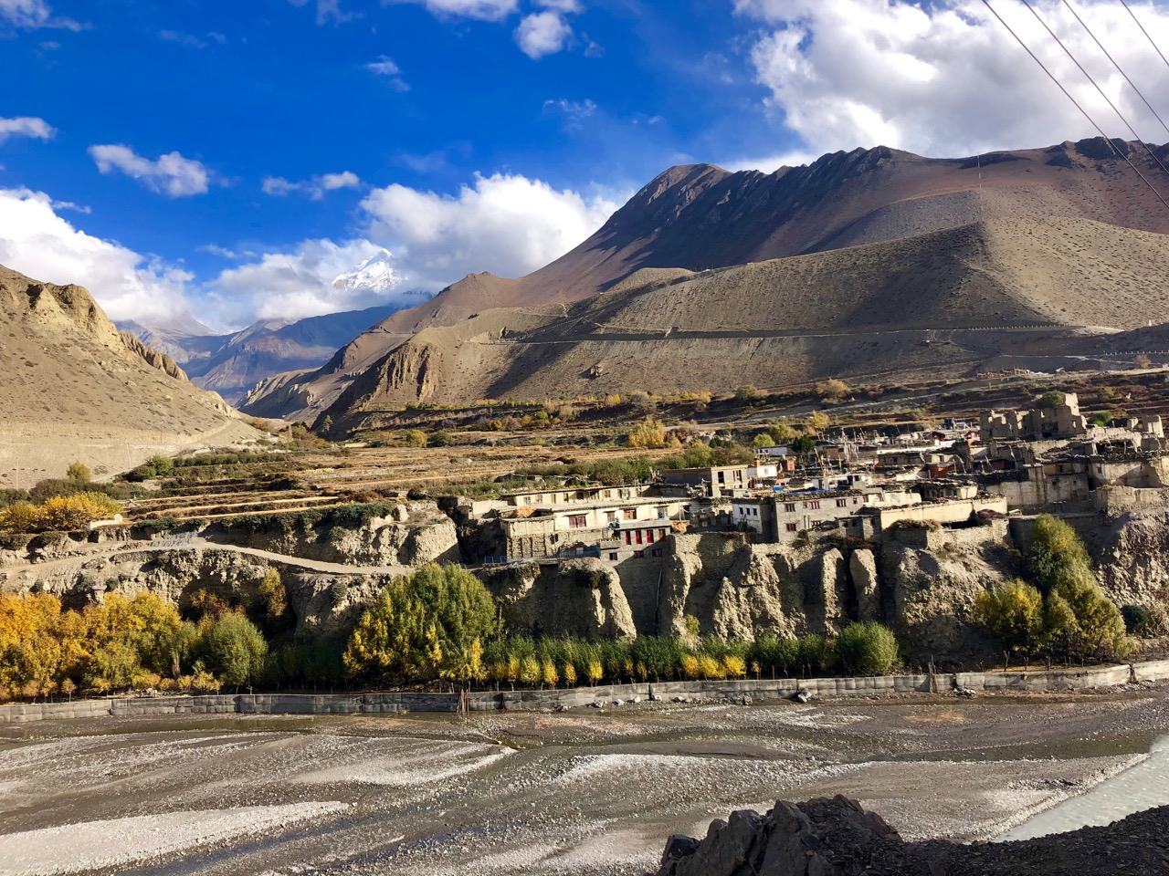
Jomsom
Also known as Dzongsam or the new fort, Jomsom is the centre of the Gharapjhong rural municipality in Mustang district and a former independent village development committee situated at an altitude of about 2,700 m in western Nepal. The soaring peaks of Dhaulagiri and Nilgiri form a backdrop to the town straddling the Kali Gandaki River, which flows right through the centre of Jomsom. Along the banks of the Kali Gandaki, black fossilised stones called shaligram, considered a symbol and reminder of Lord Vishnu can be found. Such stones are believed to be found only in the Kali Gandaki, and are considered holy by Hindus. The town is also the main hub for onward travel to Upper Mustang and Muktinath.
Jomsom lies to the north of Pokhara and is the main gateway to Upper Mustang. The trail passing through Jomsom follows the Kali Gandaki River which forms the deepest ravine in the world; on one side lies the Annapurna mountain range and on the other side is Dhaulagiri. The river freezes during winter and flows with rainwater and melting snow in summer and monsoon. With its diverse landscape, the area around Jomsom has the scenery of rocky cliffs and high peaks of the Himalayas without much presence of greenery, with the exception being forests of bright rhododendrons. The culture in Jomsom is a rich combination of Hinduism and Tibetan Buddhism.

The houses in Jomsom are designed to protect the inhabitants from the strong winds that blow in the valley every day from late morning onwards. These winds are caused by the differences in atmospheric pressure between the Tibetan plateau and the lower reaches of the valley. The best example of the unique architecture of this region is found in the village of Marpha which is a two-hour walk down from Jomsom, where one can find stone-flagged streets with an efficient underground drainage system and flat-roofed houses with a central courtyard, which best showcase the architecture of this area.
Not too far from Jomsom is Muktinath, the famous pilgrimage site for Buddhists and Hindus. For Hindus, Muktinath is a sacred place of salvation. They believe that bathing in the waters here guarantees salvation after death. The Hindu god, Lord Brahma, is said to have lit the eternal flames that burns at Muktinath. To Buddhists, Muktinath is where the great sage Guru Rinpoche or Padmasambhava who brought Buddhism to Tibet, came to meditate. The area around Jomsom is a perfect place to find fossilised ammonites, known locally as Shaligram, which are found all along the upper reaches of the Kali Gandaki.
Most of the route along the Jomsom trek forms part of the Annapurna circuit and Annapurna foothill treks. The usual starting point is Naya Pul on the Pokhara to Baglung road and from there, via Ghorepani and Tatopani, into the gorge of the Kali Gandaki. The deep valleys and high mountains encircling the giant Annapurna Himal embrace a wide range of peoples and terrain, from sub-tropical jungle to a high, dry landscape resembling the Tibetan Plateau.

Located 13 km from Jonsom, Dumba Lake is a small but picturesque attraction which is a short hike from Jomsom. Leopard Cave is an underground natural enclosure located at Thini. Rare snow leopard species are found here. Jomsom View Tower, from the height of 3750 m, offers beautiful panoramic views of the mountains of Mustang. The view tower is located at Thini, which is a short hike from Jomsom. Located on the Beni-Jomsom highway, about 40 km from Jomson, Rupse Falls is a major tourist attraction. The water falls from a height of 300 m and is surrounded by lush greenery and the world’s deepest gorge, the Kali Gandaki Gorge lies very close to the waterfall.
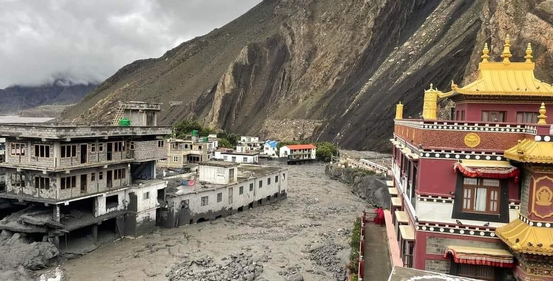
Kagbeni
A village in Upper Mustang, Kagbeni is located in the valley of the Kali Gandaki River and lies on the trail from Jomsom to the royal capital Lo Manthang, near the junction with the trail to Muktinath. Kagbeni is also regarded as one of the oldest villages in the Himalayas and lies between two sacred rivers Muktinath and Kali Gandaki. Officially Kagbeni is a settlement that bridges the gap between Lower and Upper Mustang, right at the feet of Muktinath Valley by the River Kali Gandaki. But spiritually, Kagbeni is a Tibetan village, stuck in the annals of time. In ancient times, Kagbeni was an important centre of trade for Tibetans and Indians. The famous Salt Trade Route between the two countries went through the village.
Kag Chode Thupten Samphel Ling Monastery, or the Red Monastery is the most famous landmark in the village. Built in 1429, the beauty of the monastery matches its surroundings. From outside, it looks colourful and desolate, just like the rest of Kagbeni. Inside there are sculptures of Buddha and friendly monks and a tranquil environment, where one can sit and meditate or listen to the silence. Photography is prohibited inside the monastery.
The Upper Mustang requires a special permit and USD 50 per day per person to stay and is why today many travellers prefer Kagbeni instead to get the ambience of high mountains. There are many trekking trails from Kagbeni, that lead up to the old royal capital of Lo Manthang. While trekking, one will come across Chortens and prayer wheels. Chortens are Buddhist tomb shrines, which are common in Tibetan culture and must always be crossed by the right side. The Tibetan Buddhists consider it bad luck to cross by the left. One will see numerous colourful Buddhist flags as well, planted here and there. From the summits, the entire valley can be seen, still like a painted picture on an artist’s canvas. A raw cold wind blows at this altitude at all times, and the view opens up to the vast expanses of mountain desert plains stretching into Tibet, it feels mysterious and intoxicating, but most importantly, insignificant. To stand there in front of the historical and unfathomable terrains of the Himalayas is as humbling an experience as it can be.
Mustang
Mustang which means a fertile plain was once part of the Kingdom of Lo-Manthang that joined the Federation of Nepal in 2008 after the abolition of the Shah dynasty. It straddles the Himalayas and extends northward onto the Tibetan Plateau is one of the remotest areas in Nepal and is second in terms of the sparsity of population. The elevation ranges from 1,372 to 8,167 m and includes Mount Dhaulagiri, the 7th highest mountain in the world, with several peaks above 7,000 meters.
Part of an ancient kingdom bordering the Tibetan plateau and sheltered by some of the world’s tallest peaks, Mustang still maintains Tibetan traditions because of strict regulations on the movement of tourists. Upper Mustang was a restricted area until 1992, which makes it one of the most preserved regions in the world due to its relative isolation from the outside world, with a majority of the population still speaking traditional Tibetic languages. Mustang is derived from the Tibetan word meaning the “Plain of Aspiration. It is a popular area for trekking and can be visited year-round, regardless of season. Lower Mustang is well-known for its natural scenery while Upper Mustang is famous for its trekking and hiking trails, monasteries, caves and local tribes.

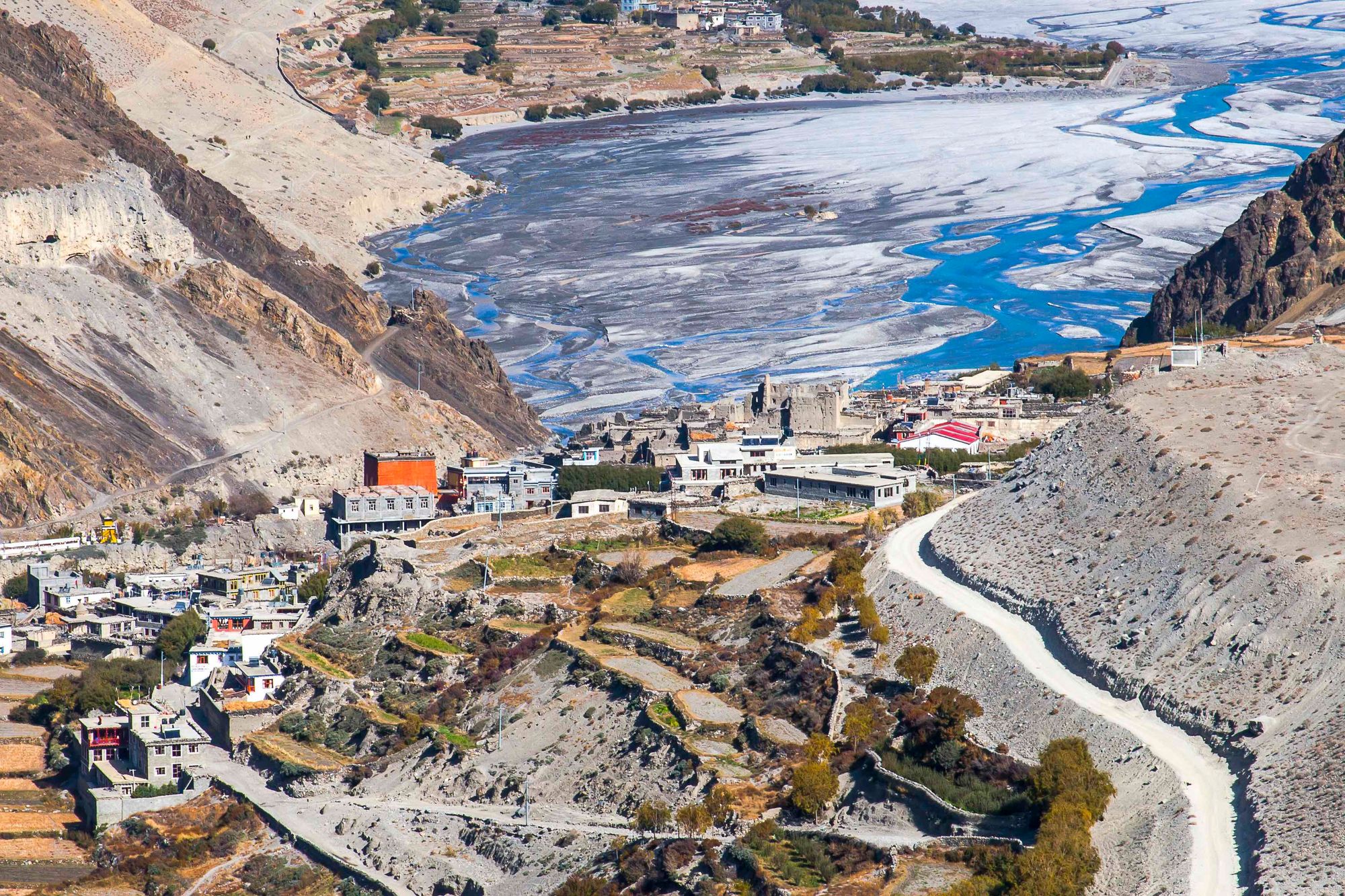
The Kali Gandaki River is a highly important feature of Mustang. Its source is located near the Tibetan border coincides with the Tibetan border and the Ganges-Brahmaputra watershed divide. From there, it flows south towards the northern Indian plains through the ancient kingdom of Mustang, flowing through a sheer-sided, deep canyon immediately south of the Mustang capital of Lo Manthang, then widens as it approaches Kagbeni where high Himalayan ranges begin to close in. The river continues southward past Jomsom, Marpha, and Tukuche to the deepest part of the gorge about 7 km south of Tukuche in the area of Lete. The gorge then broadens past the border of Mustang and Myagdi. Geographically, Lower Mustang lies between the Tibetan Plateau in the North and the high Himalayan Mountains in the South. The region between the Tibetan Plateau and the Himalayan Mountains is called Trans-Himalaya. The Kali Gandaki Gorge or Andha Galchi, measured by the difference between the river height and the heights of the highest peaks on either side, is the world’s deepest canyon.
Much of the history of Mustang is about legends rather than documented facts. However, it is believed that Mustang or the Kingdom of Lo was once a part of the Ngari area of Tibet and a loose collection of feudal estates, their history is also tied to Tibetan religion and culture, geography, and politics. It was often closely linked to adjoining kingdoms of Western Tibet and, during other periods of history, politically linked to Lhasa, the capital of Central Tibet. Lo was incorporated into the Tibetan Empire by Songtsen Gampo, the most famous Tibetan king.
From the 15th century to the 17th century, Mustang had control over the trade between the Himalayas and India because of its strategic location. In 1380, Lo became an independent kingdom under Ame Pal. The last royal family traced its lineage for 25 generations, all the way back to Ame Pal who oversaw the founding and building of much of the Lo and Mustang capital of Lo Manthang, a walled city surprisingly little changed in appearance from that period. The only remnant of these kingdoms is the still-intact Kingdom of Lo, an area corresponding to the northern third of Mustang.

In 1769, the army of Prithvi Narayan Shah, the first King of the Gorkha Kingdom and the Shah dynasty, unified what was a land of many small kingdoms to forge the kingdom of Nepal. At the end of the 18th century, the kingdom was annexed by Nepal and became a dependency of the Kingdom of Nepal in 1795. During the late 1950s and 60s, Mustang became the centre for Tibetan guerrillas engaged in small operations against the Annexation of Tibet by the People’s Republic of China in 1959. Up until 2008, the Kingdom of Lo or Upper Mustang was an ethnic Tibetan kingdom and a suzerainty of the Kingdom of Nepal. Though still recognised by many Mustang residents, the monarchy ceased to exist on 7 October 2008, by order of the Government of Nepal. The last official and later unofficial king (raja or gyelpo) of Mustang was Jigme Dorje Palbar Bista who lived between 1930 and 2016. He died on 16 December 2016 after living a retired life largely in Kathmandu since 2008 when Nepal abolished its own monarchy.
One feature of Mustang is the thousands of cliff dwellings, some highly inaccessible. These Mustang Caves or Sky Caves of Nepal are a collection of some 10,000 man-made caves dug into the sides of valleys in the Mustang. Several groups of archaeologists and researchers have explored these stacked caves and found partially mummified human bodies and skeletons that are at least 2,000–3,000 years old. Explorations of these caves by conservators and archaeologists have also led to the discovery of valuable Buddhist paintings, sculptures, manuscripts and numerous artefacts belonging to the 12th to 14th centuries. The caves lie on the steep valley walls near the Kali Gandaki River in Upper Mustang.

Lo was out-of-bounds for foreigners until 1992. Although it is now open on a restricted basis to foreign travellers, tourism to the region is still strictly restricted and hard to access. The Nepalese government have introduced a surcharge for anyone trekking past Kagbeni, which marks the border of Upper Mustang. Foreign tourists are required by the Nepalese Department of Immigration to acquire special permits, pay fairly steep fees of US$50 per day per person, and be accompanied by a liaison guide to protect local traditions and the environment from outside influence.
The ancestral isolation of Mustang helped to retain its ancient culture largely unviolated, and it survives as one of the last bastions of traditional Tibetan life. In this ancient forbidden kingdom, traditions have survived longer than in Tibet proper following its annexation by China. The lower Mustang areas such as much of Baragaon, Panchgaon, and Thak Sat Sae along the Annapurna Circuit are among the most heavily trekked routes in Nepal. The scenery of the trail ranges from forests of bright rhododendron fields to rocky cliffs and deserts. The culture along the trek is a rich combination of Hindu and Tibetan Buddhism. The trail’s highest point is Muktinath at 3800 m, a popular Hindu and Buddhist pilgrimage site for centuries. The Kali Gandaki Gorge is part of the popular trekking route from Pokhara to Muktinath. The gorge is within the Annapurna Conservation Area.
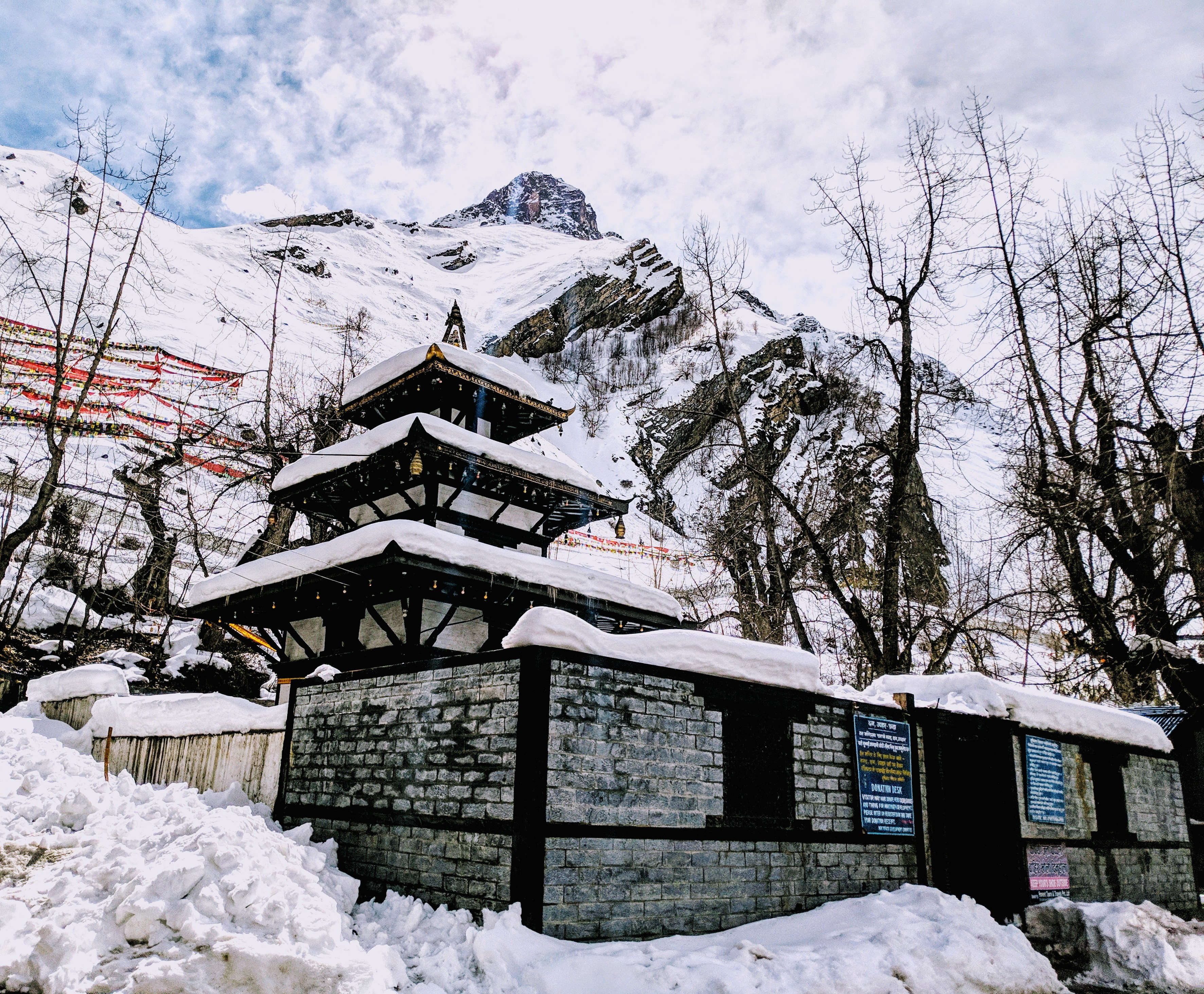
The Muktinath Temple is significant to both Hindus and Buddhists. Located in the Muktinath Valley, the shrine is close to the rural Ranipauwa, which is often mistaken to be Muktinath. The temple’s name refers to Mukti, meaning nirvana, or salvation, and nath, which signifies master, or Lord. Among the Hindus, Muktinath temple is also referred to as the Mukti Kshetra, which translates to “the place where one receives moksha or liberation”. Of the one hundred and eight sacred Shri Vaishnava temples, Muktinath Temple holds the 106th rank among the Divya Desam, or ‘premium temples’. The ideal time to visit this temple is between March to June when the temperatures are relatively warm, and the overall weather condition is pretty pleasant.
One of the eight sacred shrines, Muktinath Temple, is built in the Pagoda-styled central temple which has a gold statue of Lord Vishnu. Even though the temple is small, the main deity is almost the size of an adult man. This central statue in the temple is seen as the manifestation of Padmapani, a compassionate embodiment of all the Buddhas. In front of the temple lie two ponds, named Lakshmi Kunda and Saraswati Kunda respectively. It is a common belief that bathing in these water bodies washes off all negative forces and karma. Muktinath temple is said to have risen on its own; therefore including it as one of the eight shrines which have supposedly existed by themselves.

The outer courtyard, or the Prakaram, houses one hundred and eight waterspouts shaped like the heads of bulls, through which the sacred water of the Kali Gandaki River flows. This water symbolises the Pushkarini waters that are believed to have descended from the one hundred and eight Divya Desams. Devotees bathe in these waters even during freezing temperatures, with the hope of washing away their sins and attaining salvation.
Because of the hundred and eight water springs, the temple is also known as Chumig Gyatsa which translates to Hundred Waters. The Buddhists consider it to be an essential place for the Dakinis, the goddesses who are also known as the Sky Dancers. Legend also says it is the place where Guru Padmasambhava had meditated for some time before moving on with his journey from India to Tibet.
