
From Belgaum, today let’s explore briefly some other smaller and lesser known towns in Karnataka and then look at some of the state’s bounties from nature.
Hubli-Dharwad
Hubli, officially known as Hubballi, is the second largest city the Indian state of Karnataka. It forms a contiguous urban area with the city of Dharwad.
The name Hubballi comes from the term Hoovina Balli which means ‘Flowering Creeper’ in Kannada. Hubli is the anglicized version of Hubballi. Rayara Hubli, was the old Hubli, where there is a Bhavani Shankara temple and Jain basati. Under the Vijayanagara Rayas, Rayara Hubli grew as a commercial centre, famous for trade in cotton, saltpetre and iron. Under the rule of the Adilshahis, the British opened a factory which was looted by Shivaji Maharaj in 1673. The Mughals conquered Rayara Hubli and placed it under the governance of the Nawab of Savanur, who built a new extension named Majidpura. Hubli was conquered by the Marathas from the Nawab of Savanur in 1755-56 following which the city was conquered by Hyder Ali, only to be recaptured by the Marathas in 1790. The British took Old Hubli from the Peshwas in 1817 and the new town, with 47 other villages, was handed over to the British by the Sangli Patwardhan in lieu of subsidy in 1820. In 1880, the British started the Railway workshop and with this, Hubli came to be reckoned as an industrial centre in this part of India. The impressive Chandramauleshwara temple in Unkal is from Chalukyan times. The Sufi shrine, Sayed Fathesha Wali, was visited by Tipu Sultan.
The Chalukyas ruled Dharwad during the 12th century. In the 14th century, the district was first overrun by the Bahmani Sultanate, after which it was annexed to the newly established Hindu kingdom of Vijayanagar, when the fort was built in 1403. After the defeat of the Vijayanagar king in 1565, Dharwad was for a few years practically independent under its Hindu governor; but in 1573 the fort was captured by the sultan of Bijapur, Adil Shah, and Dharwad was annexed. Adil Shah built a fort in an area later called Manna Killa, and later Nazratabad. With this fort, the strategic importance of Dharwad increased and it attracted the attention of subsequent conquerors, including Aurangzeb, Shivaji, Aurangzeb’s son Bahadur Shah I, Peshwa Balaji Baji Rao, Hyder Ali, Tipu Sultan and finally the British.
Gulbarga
Officially known as Kalaburagi, Gulbarga is the largest city in the Hyderabad-Karnataka or the Kalyana-Karnataka region of North Karnataka. Closer to Hyderabad than Bengaluru and previously part of the Hyderabad State, it was incorporated into the newly formed Mysore State and then Karnataka in 1956 through the States Reorganisation Act.
The city is famous for its historical monuments, temples, tombs and delectable cuisine. With a history dating back to the 6th century, Gulbarga was part of the Rashtrakuta dynasty then, but the Chalukyas regained their domain within a short period and reigned supreme for over 200 years. The Kalyani Kalachuris who succeeded them ruled until the 12th century and around the end of that century, the Yadavas of Devagiri and the Hoysalas of Dwarasamadra destroyed the supremacy of the Chalukyas and Kalachuris of Kalyani. Around the same period, the Kakatiya kings of Warangal came into prominence and the present Gulbarga and Raichur districts formed part of their domain. The Kakatiya power was subdued in 1321 AD and the entire Deccan, including the district of Gulbarga, passed under the control of the Delhi Sultanate. The revolt of the officers appointed from Delhi resulted in the founding of the Bahmani Sultanate in 1347 CE by Ala-ud-Din Bahman Shah, who chose Gulbarga or as he called it, Hasanabad to be the capital. When the Bahamani dynasty came to an end in 1527, the kingdom broke up into five independent Sultanates, Bijapur, Bidar, Berar, Ahmednagar, and Golconda. The present Gulbarga district came partly under Bidar and partly under Bijapur. The last of these sultanates, Golconda, finally fell to Aurangzeb in 1687. With the conquest of the Deccan by Aurangzeb in the 17th century, Gulbarga passed to the Mughal Empire. In the early part of the 18th century, with the decline of the Mughal Empire, Asaf Jha, one of Aurangzeb’s generals, formed the Hyderabad State, in which a major part of the Gulbarga area was also included. In 1948, Hyderabad State became a part of the Indian Union, and in 1956, excluding two talukas which were annexed to Andhra Pradesh, Gulbarga district became part of new Mysore State.
Gulbarga’s Urdu name which meant “city of flowers and gardens” was renamed Kalaburagi which in Kannada means “The Land of stones and thorns” on 1 November 2014. The city is famous for it’s many religious shrines like the Khwaja Banda Nawaz Dargah, Sharana Basaveshwara Temple, and Buddha Vihar. It also has a fort built during Bahmani rule named the Gulbarga Fort, whose Jama Masjid is said to be an architectural wonder of the Brahmi kingdom. Haft Gumbad or “Seven Domes,” which lies outside the city contains the tombs of the later Bahmani sultans. Shor Gumbad, which lies to the west of Gulbarga fort on the top hill has some very fine stucco on its ceilings and the trellis and is perhaps a victory monument.
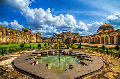
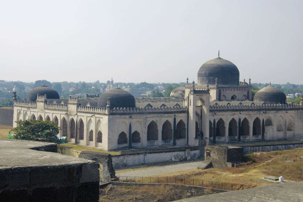
Bidar
A hilltop city bordering the Karnataka, Maharashtra and Telangana borders, Bidar is well known for its many sites of architectural, historical and religious importance. Picturesquely perched on the Deccan plateau, the Bidar fort is more than 500 years old and still standing strong. Also known as the city of whispering mounuments, the city has around 61 monuments, of which about 30 are tombs located in and around the city. Bidar is home for the second biggest Indian Air Force training centre in the country. The city is also known for its Bidri handicraft products, Bidriware, which now has GSI status. The city got its name and is considered one of the holiest place for Sikh pilgrimage. An ancient Karez System in the city has been discovered recently. The Karez or Qanat is an underground network of aqueducts for water supply with the The Bidar Karez which was built in the 15th century being more than 3 km long with 21 air vents.
Legend has associated Bidar with the ancient kingdom of Vidarbha, to which references are found in early Hindu literature like Malavikagnimitra, Mahabharata, the Harivamsa, Bhagavata, and a few other Puranas. Under the rule of the Bahmani Sultanate Bidar was known as Muhammadabad. The recorded History of the city goes back to the third century B.C. when it was a part of the Mauryan Empire. After the Mauryas, Satavahanas, Kadambas, and Chalukyas of Badami and later the Rashtrakutas reigned over Bidar territory. The Delhi Sultanate first led by Allaudin Khilji and then Muhammed-bin-Tughluq invaded the area and took control of entire Deccan including Bidar. The Brahmani dynasty was established in mid 14th century when some officers of the Delhi Sultanate rebelled. The Bidar fort is attributed to Sultan Ala-ud-Din Bahman Shah, the first sultan of the Bahmani dynasty to 1427, when he shifted his capital from Gulbarga to Bidar. During the rule of Ahmad Shah I, Bidar was made the capital city of Bahmani Kingdom and the old fort was rebuilt and madrasas, mosques, palaces, and gardens were raised. Aurangzeb wrested the Bidar Fort from the Adil Shahis after a 21-day war in 1656 and Bidar became a part of the Mughal dynasty for the second time. In 1724, Bidar became a part of the Asaf Jahi Kingdom of the Nizams. Bidar became a part of Karnataka in 1956.
The Mahmud Gawan Madrasa is a grandiose madrasa built in the late 15th century. Its imposing structure in the Brahmani style makes it a unique monument of its kind in India. Bidar Fort is considered one of the most formidable forts of the country and was a planned city. The main citadel complex housed the royal places and on the southern side, the city was built. There are five gateways for entry into the city fort. Rangeen Mahal, situated in the fort, near Gumbad Darwaza, is unique not because of its decoration with coloured tiles and other art work but because the architecture is a blend of both Hindu and Muslim styles. The walls of Mahal are adorned with mother-of-pearl of the finest quality in laid in jet-black stone. Floral patterns and calligraphic text are also depicted here. Takht Mahal, The Royal Palace, was the royal residence which was fully decorated with coloured titles and stone carvings part of which can be seen even today. The coronations of several Bahamanis and Barid Shahi sultans were held there. From the royal pavilion which is situated behind throne palace one can view the valley and low land below. The Solah Khamba Mosque or the Solah Sutoon Ki Masjid was built by Qubil Sultani between 1423 and 1424. And derives its name from the 16 pillars that are lined in the front of the structure. It is also popularly known as the Zanana Masjid. The Chaubara is a tall old cylindrical tower, 22 meters high, facing all four directions in the centre of Bidar city. It was used as a watchtower, commanding a fine view of the entire plateau from the top. A winding staircase of eight steps leads to the top of the tower, a clock is being placed on top of the tower, can be viewed from all the four directions. The Gurudwara Nanak Jhira Saheb is known to be one of holiest place for Sikhs and is believed that Guru Nanak visited the place during famine in this region. You can also find Bahmani Tombs known as Ashtur
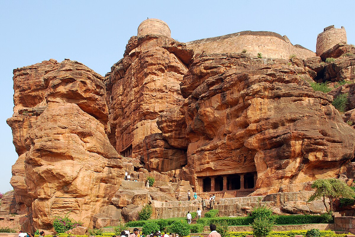
Badami
Located in a valley of rugged red sandstone, surrounding the Agastya Lake, Badami (formerly known as Vatapi) is an archaeological delight owing to its beautifully crafted sandstone cave temples, fortresses and carvings. Located in the Bagalkot district in Karnataka, Badami is part of the UNESCO World Heritage Sites that constitute Aihole-Badami-Pattadakal and is the finest example of traditional temple architecture in India.
Once the royal capital of the Chalukyas, Badami is home to a number of examples of Dravidian architecture which have instances of both South and North Indian styles of architecture. There are three Hindu Temples and one Jain Temple in Badami Caves. Rock climbing is a popular activity here for people looking for some adventure too.

Bijapur
Famous for the Gol Gumbaj and Ibrahim Rauza which is considered to be the Taj Mahal of the Deccan, Bijapur is takes its visitors back in time through its glorious ancient structures. Built around the 10th-11th century by the Kalyani Chalukyas, Bijapur was known as Vijayapura then which translates to City of Victory. Among other important attractions, there are various mosques including Jumma Masjid, palaces citadels.

Hassan
Known as the temple-architecture capital of Karnataka, Hassan derives its name from the presiding deity Goddess Hassanamba which in Kanada language mean ‘Smiling mother’. Hassan saw its development as a major seat of Hoysala Empire that ruled major parts of South India. An example of the ancient glory of Hassan is the Shettyhalli Church which was built in the 18th century. In Mosale, Nageshwara and Channakeshava reflect the Hoysala architecture of the 12th century. Hassan is mainly popular for its Jain Temples and the Hassanamba Temple.
Shimoga
Located in the central part of the state, Shimoga lies on the banks of the Tunga River. It is also nicknamed as the Gateway to Malnad. The city derives its name from the words ‘Shiv-Mukha’ implying ‘Face of Lord Shiva’. The area formed the southern tip of the Emperor Ashoka’s Mauryan Empire in the third century and was ruled during later centuries by the Kadambas, Chalukyas, Ganges, Rashtrakutas, Hoysalas, and the Vijayanagara empire. The city got an independent identity under the Keladi Nayakas’ rule during the 16th century and from the late 17th century, the city has been a part of the Kingdom of Mysore until the independence of India in 1947, when the Mysore state merged into the Republic of India. On 1 November 2006, the state government announced the renaming of Shimoga to “Shivamogga” which happened on 01 November 2014.
Mattur, a village near Shivamogga, is known for the usage of Sanskrit for daily usage and is the mother tongue of all the residents of Mattur and it’s twin village, Hosahalli. Hosahalli is situated across the bank of the Tunga River and the two villages are almost always referred to together. Mattur and Hosahalli are known for their efforts to support the Gamaka art, which is a unique form of singing and storytelling in Karnataka.

Hampi
A UNESCO World Heritage Site, Hampi is known as the city of ruins. Situated in the shadowed depth of hills and valleys, surrounded by 500 ancient monuments, beautiful temples, bustling street markets, bastions, treasury building and captivating remains of Vijayanagar Empire, Hampi is a traveller’s delight. Today an open museum with more than 100 locations to explore, it is a history’s buff’s delight.
Hampi was the capital of the Vijayanagar empire around the 14th century, and was considered the second largest city in the world at that time, after Beijing and possibly India’s richest. Over the next centuries it fell out of importance after the Vijayanagara Empire was defeated, its capital conquered, pillaged and destroyed by a coalition of muslim sultanate armies in 1565. After this Hampi remained in ruins.
Hampi’s ruins are spread over 4,100 hectares and it has been described by UNESCO as an “austere, grandiose site” of more than 1,600 surviving remains of the last great Hindu kingdom in South India that includes “forts, riverside features, royal and sacred complexes, temples, shrines, pillared halls, mandapas, memorial structures, water structures and others”. The city is surrounded by boulders of different sizes, and you can climb to the top of them with a little effort to get a stunning view of the entire city and the geography. Located on the banks of the Tungabhadra River, Hampi is famous for its massive, beautifully carved temples, especially the Virupaksha Temple, dedicated to the patron deity of the empire. You can also find remains of the old aqueducts, canals and military barracks and stables here.

The Hampi site has been studied in three broad zones; the first has been named the “sacred centre”; the second is referred to as the “urban core” or the “royal centre”; and the third constitutes the rest of metropolitan Vijayanagara. The sacred centre, alongside the river, contains the oldest temples with a history of pilgrimage and monuments pre-dating the Vijayanagara empire. The urban core and royal centre have over sixty ruined temples beyond those in the sacred centre, but the temples in the urban core are all dated to the Vijayanagara empire. The urban core also includes public utility infrastructure such as roads, an aqueduct, water tanks, mandapa, gateways and markets and monasteries, the distinction which has been assisted by some 77 stone inscriptions. Most of the monuments are Hindu; the temples and the public infrastructure such as tanks and markets include reliefs and artwork depicting Hindu deities and themes from Hindu texts. There are also six Jain temples and monuments and a Muslim mosque and tomb. The architecture is built from the abundant local stone with the dominant style being Dravidian, with roots in the developments in Hindu arts and architecture in the second half of the 1st millennium in the Deccan region. It also included elements of the arts that developed during the Hoysala Empire rule in the south between the 11th and 14th century such as in the pillars of Ramachandra temple and ceilings of some of the Virupaksha temple complex. The architects also adopted an Indo-Islamic style in a few monuments, such as the Queen’s bath and Elephant stables.
Sharavathi Valley Wildlife Sanctuary
A protected wildlife sanctuary, the Sharavathi Valley Wildlife Sanctuary is named after the Sharavathi river flowing through the sanctuary . The sanctuary is spread across the forests of Uttara Kannada & Shivamogga districts with the Sharavathi Reservoir present within the sanctuary. The sanctuary was established in 1972 with an area of 431.23 sq km and was subsequently expanded to 930.16 sq km in 2019. After expansion, the sanctuary has been renamed as the Sharavathi Lion Tailed Macaque Wildlife Sanctuary. The expanded sanctuary is aimed at protecting the freshwater habitat of Myristica swamps that hosts many species like Lion Tailed Macaque which has now been classified as endangered, the Leaf Nosed Bats, the Hornbills etc.
Bhadra Wildlife Sanctuary
Covering an area of over 490 sq km, the Bhadra Wildlife Sanctuary is located only 38 km west of the Chikmanglur town in Karnataka. Surrounded by hills of the Western Ghats on all sides, the view of the Bhadra Wildlife Sanctuary looks like a scene right out of a movie! The serrated mountains loom in the distance as the mountain peaks pierce the sky. The heaven touching apex of the mountains acts like a crown to the massive Bhadra Wildlife Sanctuary. The tanning brown forest leaves the onlooker in awe of the majesty of the massive trees, the diversity of the flora and the intricacies of the landscape. The sparkling Bhadra River passes through this sanctuary; hence its name. The river is a major source of water in the sanctuary. The sanctuary is open from 6:30 to 8:30 am and then again between 4 to 6 pm. You will need at least 2 hours to finish the sanctuary which has an entry fee of INR 400.

Brahmagiri Wildlife Sanctuary
Brahmagiri, at 1608 m above sea level, is a hill range on the Western Ghats bordering Kerala and Karnataka on the border between Wyanad District of Kerala state on the south and Kodagu or coorg District in Karnataka on the north side. The sanctuary derives its name from the highest point, the Brahmagiri peak and covers an area of about 181 km. It was declared as sanctuary on 5th June 1974. The sanctuary mainly has evergreen and semi-evergreen forests, and in the higher altitudes, there are grasslands with shola forest patches. Bamboos are well represented in these forests. The best time to visit the area is between December to February and try to avoid the monsoon season.

Nagarhole National Park
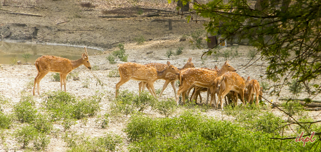
Located in the Mysore district, the Nagarhole National Park boasts of a rich wildlife as well flora and fauna. Located near Bandipur National Park, it is packed with the bounty of raw nature with the best of wildlife, forest cover and varied topography, gushing streams, gentle slopes and shallow valleys. The place is a paradise for nature lovers and those seeking solitude. A variety of species such as Elephants, Jackals, Tigers, Panthers, Gaurs, Sambars, Spotted Deers, Mongoose, Civet cats, Hyenas, Sloth Bears and over 250 species of birds call this place their home. The park is bounded by Kabini River on the north while Bandipur National park forms its southern boundaries.
A dam of the Kabini River along with its reservoir demarcates the two national parks and is a sight to behold. Other than that, the park also houses stunning vegetation and plantation along with verdant tropical and deciduous forest land. Nagarhole National Park is home to a number of reptiles such as King Cobra, Krait, Indian Rock Python, Russel’s Viper, vine snake, Tortoise, Monitor Lizard and Toads. In addition to these, trees such as sandalwood, silver oak, rosewood and teak are found in abundance here. The period from October to May is considered to be the best time to visit Nagarhole. Entry fee are INR 50 for an Indian adult, INR for a foreign adult and camera fees are INR 50 per camera. The park is open on all days between 6 to 9 am and then again from 4 to 6 pm.

Bandipur National Park
Bandipur National Park was once the hunting grounds of the Maharaja of Mysore and later established as a reserve in 1974 under the Project Tiger. It is 80 km from Mysore on the way to Ooty in Tamil Nadu and due to a lot of wildlife casualties because of speeding vehicles that go through the park, a ban on traffic between 9 PM to 6 AM has been established to ensure the safety of the animals of the park. Located in the Nilgiris, it is the first Biosphere Reserve in India and is spread over 874 sq km. The park is replete with a wide range of endangered wildlife like elephants, hornbills, deers, pythons, sloth bears, pythons, panthers etc. and multitudes of teak and sandalwood trees. Bandipur National Park is neighbours with the Nagarhole and the Wayanad Wildlife sanctuaries and is a few minutes from the Mudumalai National Park. The best time to visit the park is considered to be in the months of October to February, before the monsoon season starts. The park charges INR 250 for the entry fee. Camcorders can also be carried in at a fee of INR 200. The park is open from 6:30 to 9:30 am and then again between 3:30 to 6:30 pm. You can also take safaris inside the park. A Gypsy Safari which can take six people costs INR 3000, a bus safari costs INR 350 while a boat safari takes you along the Kabini river for a relaxing 2 hours and 45 minutes ride costs INR 2000 for Indians and children pay slightly less which can accommodate 15 people in a single boat. You can also take an elephant safari which costs INR 50 per person and which happens between 10 to 11 am most mornings. Foreigners will be charged more than Indians.
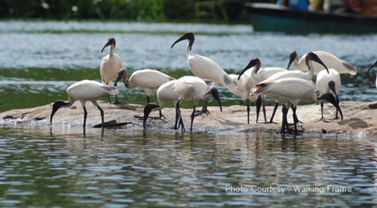
Ranganathittu Bird Sanctuary
The Ranganathittu Bird Sanctuary in Srirangapatna is a haven for bird watchers as it houses a wide array of bird species. It is the largest bird sanctuary in the state and comprises of six small islands on the banks of the river Kaveri. Popular tourist activities ones include bird watching, boating, and some good old nature photography. Out of the 170 species of bird that reside here, the most notable ones are the Painted Stork, Common Spoonbill, Asian Openbill Stork, Black-headed Ibis, and Woolly-necked Stork. This biodiversity hub also houses many small animals such as the Bonnet Macaque, Flying Fox and small mammals like common palm civet, Indian grey mongoose and the monitor lizard. Ranganathittu Bird Sanctuary is the perfect place to relax and unwind in the lap of nature and the company of family and friends. The best time to explore the raw nature of the national park is between September and May, especially around April to May. The monsoon months makes the park all lush green and verdant, however, roads are muddy and rain-soaked. Summer months, although dry, allows the visitors to witness the wildlife easily around water sources. It also serves as the best time for bird watching. The park is open from 9 am to 6 pm daily and entry fees are INR 50 for an Indian adult and INR 25 for a child who is Indian. For foreigners, the fees are INR300. If you wish to take a boat ride, Indians will pay INR 50 for an adult and INR 25 for a child while a foreigner will pay INR 300. Large cameras will incur a charge of INR 500.
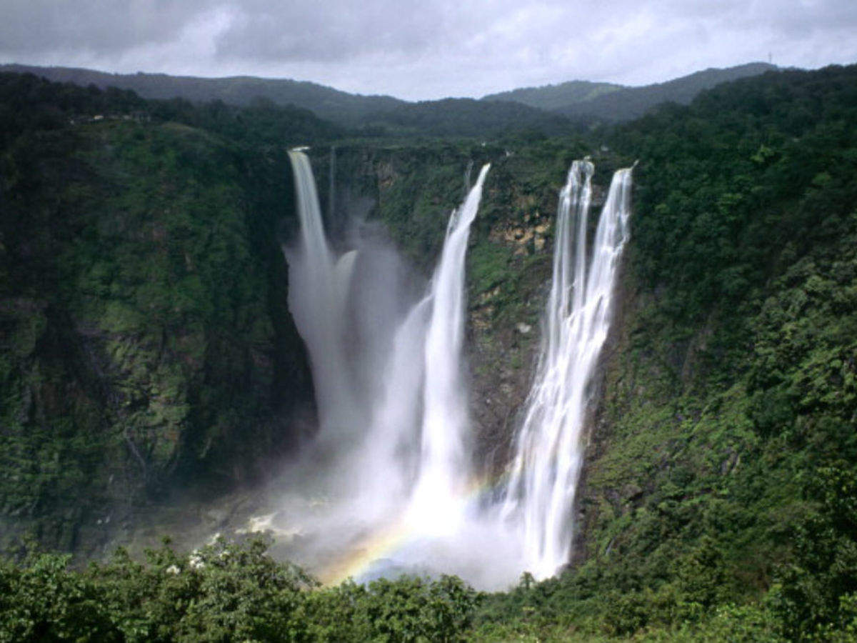
Jog Falls
The third-highest plunge waterfall in India, Jog Falls is the highest waterfall in the state, next to the Nohkalikai Falls of Meghalaya and the Dudhsagar Falls in Goa. The Jog Falls drop about a 253 m or 850 feet in a single fall on the Sharavathi river. However, due to the construction of Linganamakki Dam which is a hydroelectricity plant closeby, the flow in the falls is hugely restricted before monsoons. So, to see the falls in all its glory, make sure you visit during the monsoons. The falls are a two drive from Shimoga city. Also known as Gerosappa Falls or the Joga Falls, this seasonal waterfall is broken into four segments – Raja, Roarer, Rocket and Rani. They’re named based on certain characteristics of the streams. Raja is an unbroken stream, Roarer is a strong and violent current that gushes down to meet the Raja stream, Rocket flows down in different jets and Rani is a quiet stream with falls in foam.
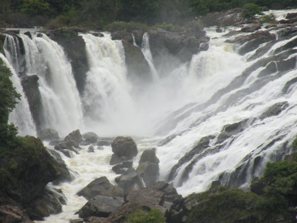
Shivanasamudra Falls
Situated on the banks of river Kaveri, Shivanasamudra is primarily a hydropower project location but has gotten massive attention for its stunning waterfalls. Literally translating to ‘Lord Shiva’s Sea’, Shuvanasamudra is a picturesque town with rocky terrain and gushing waterfalls and is a popular tourist destination with the Gaganachukki and Barachukki waterfalls being the ones you don’t want to miss. Tourists enjoy the calm town amongst the roar of the cascading waters and the view from the vantage point. This calmness is infused with subtle hints of spirituality, given the Ranganatha temple here, which attracts pilgrims. The Cauvery Wildlife Sanctuary is another important attraction here and is popular if you want to go fishing and trekking. There is parking available at the vantage point and a well-maintained place with many benches and steps which take you to many levels of vantage points. Since it’s a waterfall, it is best to visit during monsoons as it’ll be in its most glorious state. Beware of the monkeys at the vantage point though as they tend to get a bit playful and will sometimes grab your belongings. So avoid wearing jewellery and keep your wallets in your pockets and bags. There is a scarcity of restaurants near the vantage point, so either carry eatables with you or come here with a full stomach.
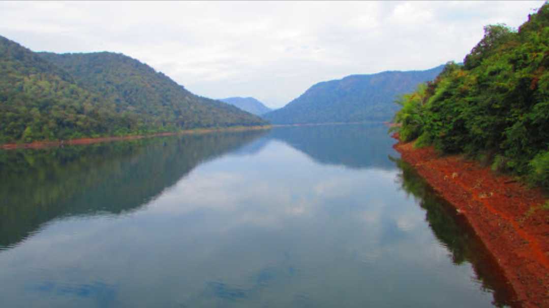
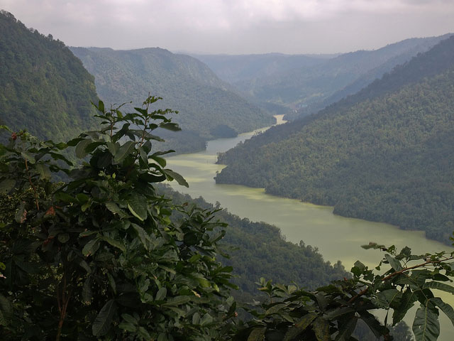
Kodasalli Backwater
The Kodasalli Backwater at Damdeli is a mesmerising pool of water accumulated behind the Kodasalli dam. The dam with the same name is constructed over the Kali river; the waters are used to generate electric power and this site is classified as a hydroelectric power station. The pool is also fed by waters gushing down from the Sathodi Waterfalls above it. On your way downhill from the Sathodi Waterfalls, a mild downward trek off route can take you to the serene and tranquil backwaters. Besides the alluring beauty of the surrounding forests and the lake view in the front, several chopped tree trunks branching out from the lake give it a pretty artistic look. A small tea stall nearby serves piping hot tea.
In the next part, we’ll look at some highs and lows in the state…
