
Formerly known as Uttaranchal, Uttarakhand is often referred to as the Devabhumi or the land of the Gods due to numerous Hindu temples and pilgrimage centres found throughout the state. was formed on the 9th November 2000 as the 27th State of India, when it was carved out of northern Uttar Pradesh, Uttarakhand is located at the foothills of the Himalayan mountain ranges and is known for the natural environment of the Himalayas, the Bhabar and the Terai regions. The state borders the Tibet Autonomous Region of China to the north; the Sudurpashchim Pradesh of Nepal to the east; the Indian states of Uttar Pradesh to the south and Himachal Pradesh to the west and north-west. The winter capital of Uttarakhand is Dehradun, the largest city of the state while Gairsain, a town in the Chamoli district is the summer capital.
Uttarakhand is rich in natural resources especially water and forests with many glaciers, rivers, dense forests and snow-clad mountain peaks. The Char-dhams, the four most sacred and revered Hindu temples of Badrinath, Kedarnath, Gangotri and Yamunotri are nestled in the mighty mountains. The state capital of Dheradun lies in the Dun Valley, on the watershed of the Ganga and Yamuna rivers. The state is blessed with a rare bio-diversity, and has 175 rare species of aromatic & medicinal plants found in the state. The state is unique in that it has almost all major climatic zones and is rich in mineral deposits.
Uttarakhand’s name is derived from the Sanskrit words Uttara meaning north, and khaṇḍa meaning land, altogether simply meaning ‘Northern Land’. The name finds mention in early Hindu scriptures as the combined region of Kedarkhand in present day Garhwal and Manaskhand in present day Kumaon. Uttarakhand was also the ancient Puranic term for the central stretch of the Indian Himalayas. However, the region was given the name Uttaranchal by the union government and Uttarakhand state government when they started a new round of state reorganisation in 1998. Chosen for its allegedly less separatist connotations, the name change generated enormous controversy among many activists for a separate state who saw it as a political act. The name Uttarakhand remained popular in the region, even while Uttaranchal was promulgated through official usage. In August 2006, after assenting to demands, the state name was formally changed to Uttarakhand.

Archaeological evidence supports the existence of humans in the region since prehistoric times. The region formed a part of the Uttarakuru Kingdom during the Vedic age of ancient India. Among the first major dynasties of Kumaon were the Kunindas in the 2nd century BCE who practised an early form of Shaivism. Ashokan edicts at Kalsi show the early presence of Buddhism in this region. During the medieval period, the region was consolidated under the Katyuri rulers of Kumaon also known as the Kurmanchal Kingdom. After the fall of the Katyuris, the region was divided into the Kumaon Kingdom and the Garhwal Kingdom. In 1816, most of modern Uttarakhand was ceded to the British as part of the Treaty of Sugauli. Although the erstwhile hill kingdoms of Garhwal and Kumaon were traditional rivals, the proximity of different neighbouring ethnic groups and the inseparable and complementary nature of their geography, economy, culture, language, and traditions created strong bonds between the two regions, which further strengthened during the Uttarakhand movement for statehood in the 1990s.
Ancient rock paintings, rock shelters, paleolithic stone tools which are hundreds of thousands of years old, and megaliths provide evidence that the mountains of the region have been inhabited since prehistoric times. There are also archaeological remains that show the existence of early Vedic practices from around 1,500 BCE in the area. The Pauravas, Khasas, Kiratas, Nandas, Mauryas, Kushanas, Kunindas, Guptas, Karkotas, Palas, Gurjara-Pratiharas, Katyuris, Raikas, Chands, Parmars or Panwars, Mallas, Shahs and the British have ruled Uttarakhand in turns. It is believed that the sage Vyasa scripted the Hindu epic Mahabharata in the state.
Among the first major dynasties of Garhwal and Kumaon were the Kunindas in the 2nd century BCE who practised an early form of Shaivism and traded salt with Western Tibet. It is evident from the Ashokan edict at Kalsi in Western Garhwal that Buddhism made inroads in this region. Shamanic Hindu practices deviating from Hindu orthodoxy also persisted here. However, Garhwal and Kumaon were restored to nominal Vedic Hindu rule due to the travels of Shankaracharya and the arrival of migrants from the plains. Between the 4th and 14th centuries, the Katyuri dynasty dominated lands of varying extent from the Katyur valley in modern-day Baijnath in Kumaon. The historically significant temples at Jageshwar are believed to have been built by the Katyuris and later remodelled by the Chands. Other peoples of the Tibeto-Burman group known as Kirata are thought to have settled in the northern highlands as well as in pockets throughout the region, and are believed to be ancestors of the modern day Bhotiya, Raji, Jad, and Banrawat people.

By the medieval period, the region was consolidated under the Garhwal Kingdom in the west and the Kumaon Kingdom in the east. During this period, learning and new forms of painting like the Pahari school of art was developed. Modern-day Garhwal was likewise unified under the rule of Parmars who, along with many Brahmins and Rajputs, also arrived from the plains. In 1791, the expanding Gorkha Empire of Nepal overran Almora, the seat of the Kumaon Kingdom, who annexed it to the Kingdom of Nepal and in 1803, the Garhwal Kingdom also fell to the Gurkhas. After the Anglo-Nepalese War, this region was ceded to the British as part of the Treaty of Sugauli and the erstwhile Kumaon Kingdom along with the eastern region of Garhwal Kingdom was merged with the Ceded and Conquered Provinces. In 1816, the Garhwal Kingdom was re-established from a smaller region in Tehri as a princely state.
After India’s independence, the Garhwal Kingdom was merged into the state of Uttar Pradesh, where Uttarakhand composed the Garhwal and Kumaon Divisions. Until 1998, Uttarakhand was the name most commonly used to refer to the region, as various political groups, began agitating for separate statehood and on 9 November 2000, Uttarakhand became the 27th state of the Republic of India.
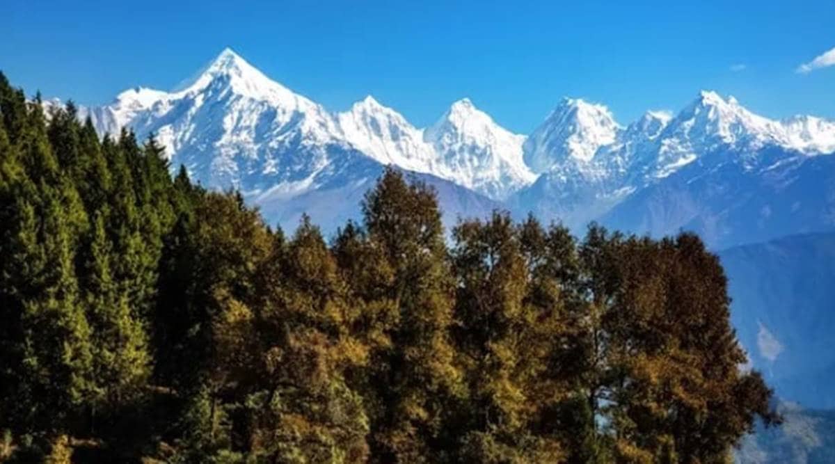
86% of Uttarakhand is mountainous and 65% is covered by forest. Most of the northern part of the state is covered by high Himalayan peaks and glaciers. Two of the most important rivers in Hinduism originate in the glaciers of Uttarakhand, the Ganges at Gangotri and the Yamuna at Yamunotri and are fed by myriad lakes, glacial melts and streams. These two along with Badrinath and Kedarnath form the Chota Char Dham, a holy pilgrimage for the Hindus.
The state hosts the Bengal tiger in Jim Corbett National Park, the oldest national park of the Indian subcontinent. The Nanda Devi and Valley of Flowers National Parks, a UNESCO World Heritage Site located in the upper expanses of Bhyundar Ganga near Joshimath in Gharwal region, is known for the variety and rarity of its flowers and plants. The Himalayan ecosystem provides habitat for many animals, including bharal, snow leopards, leopards and tigers, plants, and rare herbs.
As I usually do, let’s start with the state capital of Dehradun.

Dehradun is the winter capital and the most populous city of Uttarakhand. Part of the Garhwal region, Dehradun is located in the Doon Valley on the foothills of the Himalayas nestled between the river Ganges on the east and the river Yamuna on the west. The city is noted for its picturesque landscape and slightly milder climate and provides a gateway to the surrounding region such as Mussoorie and Dhanaulti as well as summer and winter trekking destinations like Dodital and Dayara Bugyal for camping and grandeur Himalayan panoromic views. The Hindu holy cities of Haridwar and Rishikesh along with the Himalayan pilgrimage circuit of the Char Dham which include Yamunotri, Gangotri, Kedarnath and Badrinath.
During the days of British Raj, the official name of the town was Dehra. Dehradun is made up of two words Dehra and Dun. Dehra is derived from the word dera, meaning camp, and Dun or Doon in Garhwali language refers to a valley that lies between the middle Himalayas and the Shivaliks. The town was established when Baba Ram Rai, the son of the seventh Sikh Guru, Guru Har Rai settled his Dera or camp in the area in 1675 whichh is when the modern city of Dehradun started to develop. In the Skanda Purana, Dun is mentioned as a part of the region called Kedarkhand, the abode of Shiva. According to Hindu mythology, in ancient India during the Mahabharata era, Dronacharya the great teacher of Kauravas and Pandavas, lived here hence the city is also known as Dronanagari or thecity of Drona.
It is believed that after the battle between Ravana and Lord Rama, Lord Rama and his brother Lakshmana visited this site. Ancient temples and idols have been found in the areas surrounding Dehradun which have been linked to the Ramayana and Mahabharata and these relics and ruins are believed to be around 2000 years old. Rishikesh is mentioned when Lord Vishnu answered the prayers of the saints, slaughtered the demons and handed the land to the saints. In the seventh century, this area was known as Sudhanagara and was described by the Chinese traveller Huen Tsang and later came to be known as Kalsi.
Dehradun was invaded by Mahmud of Ghazni during his campaigns into India followed by Timur in 1368, Rohilla chief Najib ad-Dawlah in 1757 and Ghulam Qadir in 1785. In 1806, the Nepalese King Prithvi Narayan Shah united many of the Indian territories that now fell under places such as Almora, Pathankot, Kumaon, Garhwal, Sirmur, Shimla, Kangra and Dehradun. On the western front Garhwal and parts of Himachal Pradesh up to Punjab and on the eastern front the state of Sikkim up to Darjeeling became parts of Nepal for a brief period until the British East India Company went on the war from 1814 to 1816. The war ended with the signing of the Treaty of Sugowli where almost a third was ceded to British East India company. The British got Dehradun in 1816 and colonised Landour and Mussoorie in 1827–1828. Post-independence Dehradun and other parts of Garhwal and Kumaon were merged with United Provinces which was later renamed the state of Uttar Pradesh. In 2000, the state of Uttarakhand was created from the northwestern districts of Uttar Pradesh under the Uttar Pradesh Reorganisation Act 2000 and Dehradun was made its interim capital.
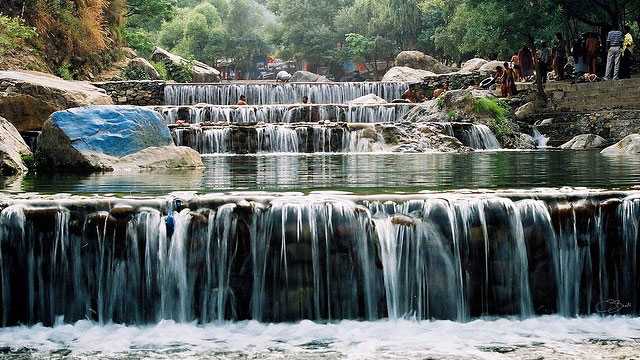
Sahastradhara: Literally meaning a thousand-fold spring, Sahastradhara is a popular attraction, famous for its medicinal & therapeutic value as its water contains sulphur. Sahastradhara is located about 14 km from the city, near Robber’s Cave. Also known as Sulphur Springs, this waterfall cascades through limestone stalactites from a height og around 9 meters, making the water rich in sulphur. A dip in the Sulphur-rich water here feels cold and refreshing but is believed to have remarkable medicinal advantages. The temperature of the water here is a little lower than its surroundings and its picturesque beauty attracts a lot of travellers. One can even enjoy a stunning view of the mountains on a fun ropeway ride. The falls are open from 8 am to 7 pm daily.
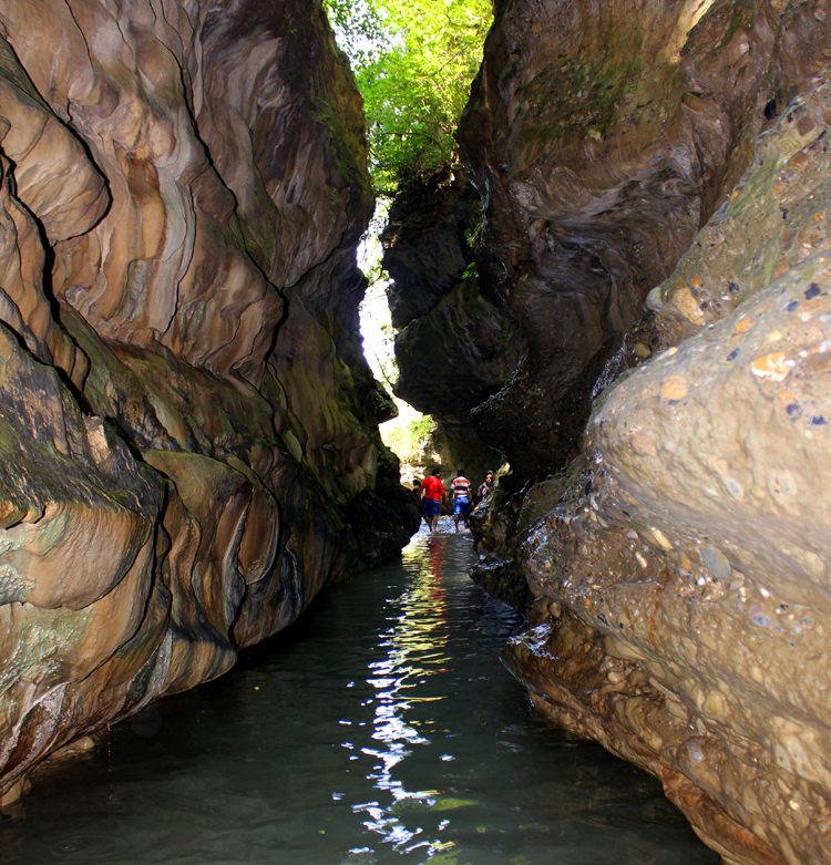
Robber’s Cave: Locally known as Gucchu Pani, Robber’s Cave is a river cave formed in the Himalayas, about 8 kilometres from Dehradun. This river cave is believed to be an abode of Lord Shiva and is very close to Sahasradhara and is speciality is that river water flows out from the middle of the cave. The cave is a narrow gorge formed between a conglomerate limestone formation. It creates a feeling similar to being in a scene from a mystery movie, surrounded by dark limestone as streams gush in, echoing inside the cave. With cold water underground springs, the cave cools down during the scorching-hot summer-afternoon and is a perfect picnic spot amidst the natural beauty of Uttarakhand. It is said that the cave got its name from the British after they found out that robbers kept stolen items in the cave. While the cave has elegant natural interiors, the most exquisite feature of Robber’s Cave is its 10 m high waterfall. The water in the cave appears and then, all of a sudden, vanishes underground. The water appears again on the surface a few yards away. You may also visit the Tibetan Buddhist Temple, the Takpeshwar Temple, the Ramakrishna Ashram Temple and the Dehradun Zoo; each being 2 to 4 kilometres away from Robber’s Cave.

Maldevta: located in Shripur, Maldevta offers one of the vistas of nature’s perfection, with the great Himalayas in the backdrop, the pristine Song rRiver gurgling through thick shrubberies and little birds hopping and chirping about the area. Visitors are many during the summer months, as people often come to take a chilling and refreshing dip in the river. You can indulge in a little adventure and trek through the thick wilderness and stroll around and observe birds on the go. A temple sits, most solemnly on the lap of nature, adding to the beauty. Maldevta is also famous among campers, but as the place is thickly populated with flora and fauna, campers are advised to come in groups, as wild animals tend to come out of their hideout after sunset. Maldevta is open from 10 am to 6 pm and the best time to visit is during summer, between April to July, though it is open all year round.

Lacchiwalla: Located in the forest area of Rajaji, Lacchiwalla is famous for its greenery, picturesque cottages and hotels. The brook serves as a natural water park where people can get engaged in all sorts of water activities such as swimming, boating, etc. However, one must remember to carry one’s swimming equipment as the authorities do not provide anything as such. The place is especially popular among families to hang out on weekends. It also has a garden with several monkeys menacingly hanging around and about the trees. It is open from 8 am to 5 pm in the summer and from 9 am to 5 pm in winter. Entrance fees are INR 20 for adults and INR 10 for children below the age of 12 while parking fees are INR 50 for four wheel vehicles.
Har Ki Dun: Nestled away from the hustle bustle of the city, Har Ki Dun, also known as the Valley of Gods is a beautiful cradle shaped valley with untouched panoramic beauty. Perched at an elevation of 3,566 mts above the sea level, this place is one of the remotest areas of Uttarakhand offering a plethora of trekking excursions. Here, you will find yourself surrounded by thick Pine forests and scintillating mountain peaks. This beautiful trail will take you to some of the most unexplored areas of the Garhwal Himalayan region where the simplicity and rustic lifestyle of the residents of hills is still untouched by the time. The beautifully carved houses along the way add to the charm of this trek. Visit this splendid place if peaceful nature and adventure is what you are looking for. The best time to visit is between March and June and then again between September and November. The trek will take approximately eight days.

Bali Pass: One of the least explored treks in the Indian Himalayan region that connects the Har Ki Dun Valley with Yamunotri, the Bali Pass Trek is a beautiful journey that one should try at least once in a lifetime. Bali Pass, which is set at an elevation of about 4,800 meters and located in the heights of Garhwal Himalayan region, is an exhilarating getaway where from you can capture the majestic trio of Kalanag at 6,387 meters, Bander Poonch 6,316 meters and Swargarohini group of peaks at a maximum elevation of 6,252 meters. The trail crosses the Govind National Park, which houses several colourful orchards and species of animals and birds, pens and clicks the trekker’s diary and lenses with enrapturing moments. The trail is best explored between May and June and between September and October and takes about ten days to cover. The entry fees for the trek is between INR 9,000 and INR 13,000.
Kalsi: A small village near Dehradun, Kalsi is known as the gateway to the Jaunsar-Bawar tribal region and is located between Dehradun and Chakrata hill station along the banks of the river Yamuna and is the confluence of the rivers, Yamuna and Tons. Inhabited by the people from the Khils, Bhutis and Mundar communities, Kalsi is surrounded by lush green oak and sal trees and a vast green valley, offering visitors an enchanting view of the Garhwal Himalayan ranges. Summertime is arguably the best period to visit Kalsi as the weather is much nicer and suitable for the outdoor activities with the morning hours being the best time for walking the trails. On the other hand, the periods of October to November and February to March is usually when you will see the migratory birds gather at Asan Barrage, sothere never really is a bad time to visit Kalsi. Where there, make sure, you visit the Ashokan Rock Edict which is a pear-shaped quartz rock onto which the fourteenth edict of King Ashoka is inscribed. The Pali language and the Brahmi script used in these edicts reflect upon the humane nature of Ashoka as a king and his concern for the welfare of his subjects. The names of five great Greek kings can be found engraved on the edict which conclusively dates it back to 253 BC. Dakpathar is an ideal picnic spot with many recreational water sports and activities including boating, canoeing, sailing, river rafting, water skiing, and even hovercrafts. Chakrata Hills is a hill station about 43 kms from Kalsi and offers visitors views of the towering Chakrata hills and ravishing waterfalls and also trek along the Chakrata Pass which winds along some of the waterfalls, including the very famous and beautiful Tiger Pass. If you are looking to soak in a bit of history along with the scenery, then the Timli Pass is worth visiting. This place is regarded to be historically significant as it is believed to have bore witness to the battle between the British army led by Major General Ochterlony and the Gorkhas.

Asan Barrage: Known for the many endangered migratory birds that flock here at various times of the year during their migrations, the Asan Barrage is a bird watcher’s paradise with its artificial lake attracting thousands of birds of varied species. Also known as the Dhaulipur Lake, the Assan Barrage was formed due to the confluence of two great rivers, the Assan and Yamuna rivers. Many exotic birds such as the red-crested pochards, coots, cormorants, wagtails, greater spotted eagles, osprey, marsh harriers, etc, can be seen in all their glory. A majority of bird species which migrate over the Himalayas during the winter season, stop over here on their journey towards the south of India. The lake and barrage is open during the daytime and has no entry fee.
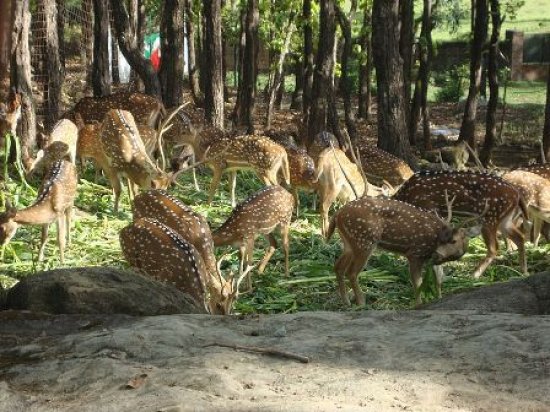
Malsi Deer Park: Located at the base of the Shivalik range in Dehradun, the Malsi Deer Park, also known as the Malsi Zoo, is a zoological garden and heaven for nature lovers, with the beauty of the place highlighted by rich flora and fauna. It is a small zoological park with a picturesque location and vibrant wildlife, making it an amazing place for photographers. Though the park is mainly famous for deer, visitors can also spot peacock, nilgais, rabbits, and tigers to name a few. Apart from the nilgais, the park is home to Himalayan antelopes and the park is a part of the Malsi Forest Reserve. The park is closed on Mondays and on other days, it is open from 10 am to 5 pm and has an entry fee of INR 10 per person.

Tapovan Temple: Situated on the banks of the river Ganga, the Tapovan temple is a holy place which is located 5 km from Dehradun. All sorts of holy Hindu rituals are performed at the ashram which also conducts yoga courses for those interested. Surrounded by greenery a visit to this temple is known for releasing the tension and providing a sense of satisfaction as well as peace of mind. Tapovan as a place holds a lot of spiritual importance because according to Hindu mythology, Guru Dronacharya who was the teacher of the Kauravas and Pandavas in Mahabharat underwent his forfeit here. The word Tapovan has been derived from two words, Tapasya which means rigour and van which means forest. The temple and ashram are open from 6 am to 8 pm daily.
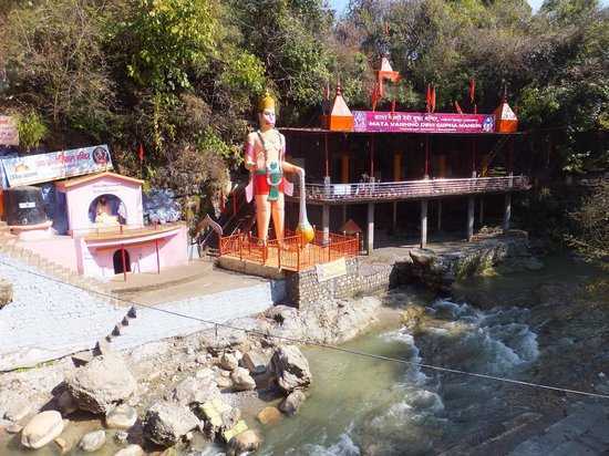
Tapkeshwar Temple: Also known as the Tapkeshwar Mahadev Temple, the Tapkeshwar Temple is located 6.5 kms from Dehradun’s city centre. A humble cave shrine dedicated to Lord Shiva, this temple is situated along the banks of a river which imparts it a unique sanctity. This cave was once the abode of the famous guru Dronacharya and hence is also known as Drona cave. A Shiva Linga is enshrined in the main complex which is believed to grant the wishes of all those who seek the Lord’s blessings. Water trickles from the ceiling continuously on the Shivalinga, making it an interesting spectacle to watch. Cool sulphur water springs here are available for pilgrims to take a bath in before they enter the main temple. The Tapkeshwar Temple, while simple and charming in its appearance, is a popular destination and is also thronged by young travellers as a picnic spot. To reach the temple, one has to take a short trek through the forest. The best time to visit the temple is during Shivratri, during which a large-scaled festival is organised to mark the occasion. Elaborate prayer services are held and pilgrims offer Lord Shiva’s favourite eatables to him on the day. A widespread legend says that Ashwathama, the son of Dhronacharya, was born inside the cave. However, his mother did not have enough milk to be able to feed her newborn. Ashwathama was wise beyond his years, and he prayed to Lord Shiva to grant him some milk to satiate his hunger. Being the generous God he is, Lord Shiva granted the wish of the newborn for milk to suffice his hunger. Since then, a Shiva Linga has been established there which is said to grant the wishes of all those who visit this temple seeking the Lord’s blessings. The Tapkeshwar Temple is a gentle amalgam of manmade and natural design. It is situated between two gentle hills, while the main sanctum is contained within the bounds of a naturally occurring cave. The architecture itself pertains to typical Hindu style. The temple is open daily from 6 am to 7 pm.

Ram Rai Gurudwara: Established by Ram Rai, the eldest son of the seventh Guru of the Sikhs, Sri Har Rai ji in 17th century, the Ram Rai Gurudwara in Dehradun is one of the oldest gurudwaras and a popular pilgrimage centre for adherants of the Sikh faith. There is an annual fair is held every year on the 5th day after Holi, the festival of colors.
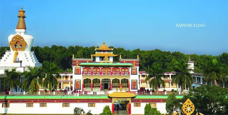
Mindrolling Monastery: Also known as the Buddha Temple Complex, the Mindrolling Monastery was established in Clement Town, Dehradun by Khochhen Rinpoche in 1965. Situated in the middle of the serene foothills of the Himalayas, the Mindrolling Monastery is one of the largest Buddhist centres in India which attracts thousands of visitors. Being an architectural masterpiece with several sections, the monastery is a visual wonder. The monastery exudes beauty owing to its gardens, university complex and the tallest Stupa in Asia. While surrounded by greenery, it also has numerous shrine rooms, Tibetan art forms, and murals. What catches the attention of every tourist is the presence of the tall statue of Lord Buddha. One of the six major monasteries of the Tibetan Nyingma School, this monastery was first established in 1676. The Ngagyur Nyingma College is also present within the premises offering advanced Buddhist studies to monks. The monastery has wall paintings inside which showcase the life of Lord Buddha and has been built in the Japanese style of architecture with the Stupa, also known as the Great Stupa, inaugurated in 2002 as one of its major attractions. It has a height of 220 feet and a width of 100 square feet, making it the largest stupa in Asia. The monastery has five floors with statues of Lord Buddha and Guru Padmasambhava. There are ornate gold colour wall paintings present on the first three floors and an open platform offering a huge 360-degree view of the Dehradun Valley on the fourth floor. Visitors are allowed to go on the upper floor on Sundays only. Another distinguishing factor of the monastery is the 130 feet tall statue of Lord Buddha inside. The Mindrolling Monastery was constructed by Rigzin Tendak Lingpa in 1676. In 1965, it was re-established by Khochhen Rinpoche with the help of fellow monks. The Buddha Temple Complex was built with the aim to protect the religious and cultural understanding of the Nyigma school of Buddhism, being one of the four schools of Tibetan Buddhism. The other schools are known as Sakya, Kagyu, and Gelak. Around 50 artists were involved in the design and construction of the monastery which took almost three years to complete. The monastery is open from 8 am to 12 noon and again between 2 to 7 pm during the summer months and from 9 am to 12 noon and again between 1:30 to 6 pm during the winter months.

Clock Tower: Also known as the Ghanta Ghar, the Clock Tower is a very famous tourist attraction. Construction for the tower began in 1948 and completed in 1953 and inaugurated by Lal Bahadur Shastri. The clock does not work at present, but it is said that years ago when it was built, it was said a person on the other end of the city could hear the clock when it rang. The clock tower is situated on the Rajpur Road and is surrounded by numerous business centers. The tower has a gold plate on top of it which has all the names of the freedom fighters who fought for the independence of the country. Originally, the tower was named Balbir tower and was built to mark India’s independence. Sarojini Naidu, the then Governor of Uttar Pradesh, laid the base of the monument in 1948. It is 85m tall and has an exclusive architecture with six faces.
Moving on, let’s travel about 35 km north to the hill station of Mussoorie.
