
After Amaravathi, Vijayawada and Machilipatnam, let’s see what else Andhra Pradesh has to offer.

Guntur
Known as the Land of Chillies, Guntur is famous for its massive chilli market yard. It is the 24th most densely populated city in the world, 11th most in India and third most populous town in Andhra Pradesh located at a distance of 30kms from the newly coined capital Amaravathi and forms a part of the new AP Capital Region. The earliest reference to the present name of the city can be dated back to the period of Ammaraja I who ruled between 922 and 929 AD, the Vengi Eastern Chalukyan king. In Sanskrit, Guntur was referred to as Garthapuri, which translates to a place surrounded by water ponds. The earliest recorded reference of Guntur comes from the Idern plates of Ammaraja I. The inscriptions stones in the Agastyeshwara temple in the Naga Lipi, an ancient script, dates back to about 1100 AD in old Guntur and is considered one of the its famous temples. The region has been historically known for Buddhism and the first Kalachakra ceremony performed by Gautama Buddha himself. With the arrival of the Europeans in the late sixteenth century the city attained national and international significance when the French shifted their headquarters from Kondavid Fort to Guntur in 1752. The Nizams of Hyderabad and Hyder Ali also ruled the city until it came under British rule in 1788. With a busy industrial scenario, Guntur forms part of the prominent Vishakhapatnam-Guntur Industrial corridor and is renowned as a textile and transport hub in India.
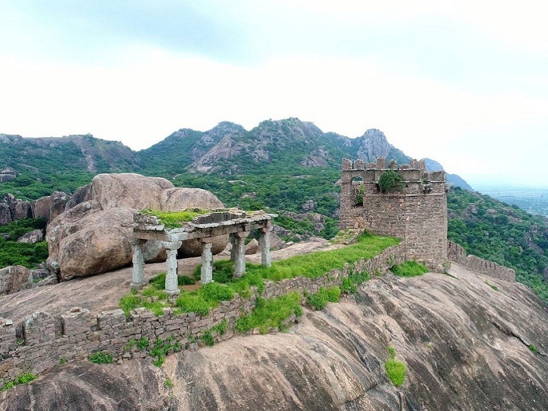
Kondaveedu lies about 17 miles from Guntur and houses an ancient fort belonging to the 13th century built by the Reddy kings comprising of 21 magnificent structures. Situated on the top of the hill, the views from the fort are amazing. The place also offers an ideal trail for trekking. A group of several temple located at the base of the hillock provides a captivating sight with Kathulabave and Gopunatha Temple being two of the many temples in the area. The best time to visit the fort is between October and March and the fort is open all days and has no entry fees.
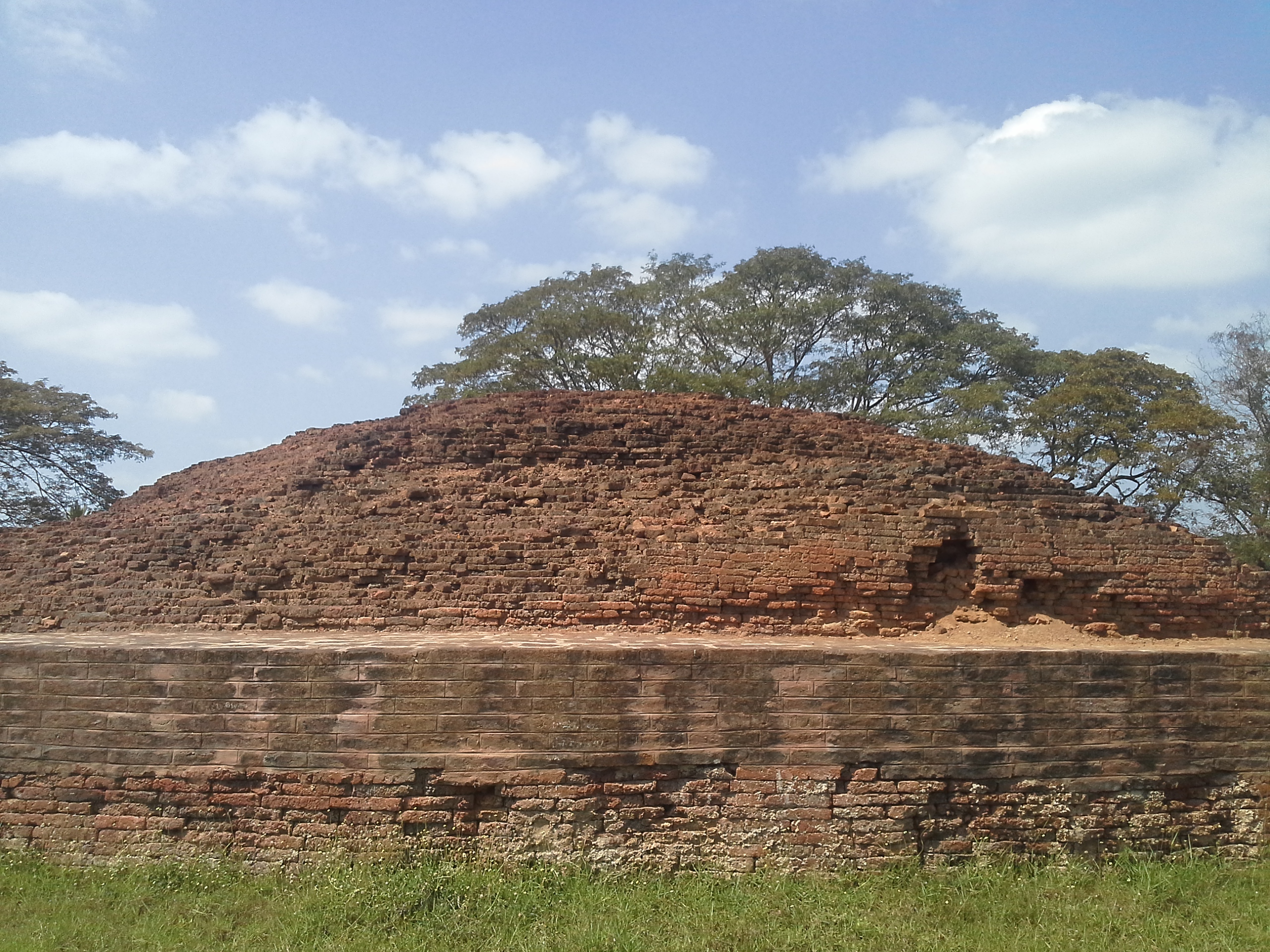
Bhattiprolu is a small village mainly known for its Buddhist stupa that is a centrally protected monument of national importance. Originally known as Pratipalapura, Bhattiprolu was ancient Buddhist town that used to flourish during the rule of the Sala dynasty. As per records, King Kuberaka used to rule this town around 230 BC and the stupa is known to have been built around the 2nd and 3rd centuries BC. The stuapa was found during excavations between 1870 and 1892. Boasting of a diameter of 40 m, and an additional basement of 2.4 m, the great stupa is also called the Mahachaitya. The Mahachaitya also has a large halls with several pillars, some ruined votive stupas which have several stupas of Lord Buddha. Besides this, there were also some stone receptacles found- which contained a copper vessel, silver casket and golden casket, with enclosed beads of bone and crystal etc. During exavations in Bhattiprolu, examples of the Brahmi script were found written on an olden urn with the relics of Buddha. This script has been named as the Bhattiprolu Alphabet and experts believe that the Telugu and Kannada script was inspired by the same.
Originally known as Kondakavuru, Kotappakonda Trikutaparvattam is famously known as Kotappakonda or Trikutaparvattam meaning a three-peaked hill which actually lies nearby. Located nearly 25 miles from Guntur, it offers a panoramic view of majestic hills from any direction. The popular three peaks derive their names from Hindu mythology namely Vishnu, Brahma and Maheswara. Another place worth visiting is Guthikonda Cave as well as the Someswara Swamy temple is another popular place to visit. Kotappakonda Trikutaparvattam is open daily from 6 am to 12:30 pm and then again between 3 to 8 pm.
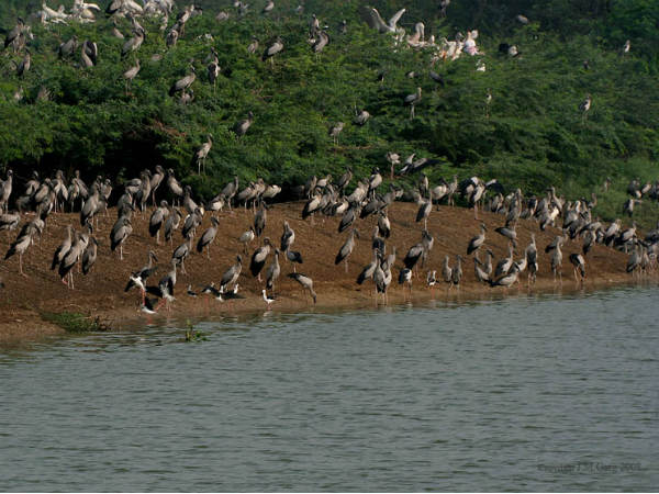
A place to admire a large number of endangered species of Birds, the Uppalapadu Bird Sanctuary is situated in the southern side of the city. The water tanks in the region are a perfect place to enjoy a beautiful spectacle of birds like the spot-billed pelicans and painted storks. The number of bird species has, however, has reduced in the recent time from 12,000 to 7000. There is an entry fee of INR 30 per person.

Chirala
Also known as Ksheerapuri, which translates as the town of milk, the peaceful town of Chirala was founded by Minchala Paleti Papayya and Minchala Paleti Perayya. Over time, the name changed to Chirala, where Chira means a sari. The town and the surrounding areas are known for their high-quality hand-loom industry and is known as Mini Bombay or Chenna Bombay. Chirala is famous for its quiet beaches, splendid panoramic view and extremely hospitable people. The beaches of Chirala are untouched by human malice and over-population. The two prime beaches of the town include the Ramapuram Beach and the Vodarevu Beach which are famous for their silent and peaceful nature, where one can hear the waves roaring and chirping of birds with unparalled sunrises and sunsets. Chirala is an abode of magnificent temples, churches and glittering local market. Some of the noteworthy places include the St. Mark’s Lutheran Church, the Veera Raghavaswamy temple, the Padmanabhuni Swami Temple, the Sai Baba Temple, the St. Luke Church and the Pooleramma temple.

Nagarjunakonda
An island today, Nagarjunakonda is a historical town, located near Nagarjuna Sagar, near the state border with Telangana. The ruins of several Mahayana Buddhist and Hindu shrines are located at Nagarjunakonda which is one of India’s richest Buddhist sites, and today lies almost entirely under the Nagarjunasagar Dam. The town is named after Nagarjuna, a southern Indian master of Mahayana Buddhism who lived in the 2nd century, who is believed to have been responsible for the Buddhist activity in the area. The site was once the location of many Buddhist universities and monasteries, attracting students from as far as China, Gandhara, Bengal and Sri Lanka. 3rd and 4th century inscriptions discovered there make it clear that it was known as Vijayapuri in that period with the name Nagarjunakonda dating to the medieval period. The Ikshavaku inscriptions invariably associate their capital Vijayapuri with the Sriparvata hill, mentioning it as Siriparvate Vijayapure.

Situated at the top of the hill, the Nagarjunakonda Caves depict the life of the Buddhist civilisation that existed here. From the beautifully carved sculptures, the inscriptions on the cave walls to the life sized statues and relics of the Buddha, this cave offers a visual treat. Apart from this, there is another cave situated underground and is horizontal and is said to be the second largest cave in the Indian sub-continent. The museum in the premises offers a collection of excavated artifacts belonging to the era. Open daily from 7:30 am to 7:30 pm, there is no entry fee to access the caves.

The chief abbot of Nalanda University, Acharya Nagarjuna established a University and meditation centre known as Dhamma Nagajjuna and many people from far and near came to learn the Dhamma and helped in spreading it all over Southeast Asia. Today this is known as Nagarjuna Sagar and is a Vipasna meditation centre that teaches the Buddhism way of living. The basic course is of a 10 day meditation programme, free of cost and involves living there with minimal belongings and attaining oneness with nature and oneself. The course is conducted in Hindi, Telugu and English. Though the course is free, prior reservations need to be made.

The world’s largest masonry dam protected with 26 gates measuring 14m in height and 13m in width, the Nagarjunasagar Dam is built across the Krishna river. The dam has a storage capacity of nearly 11,472 million cubic meters with an irrigation capacity for 10 acres of land. The dam is 150 m tall and is 16 kms in length while also being a major tourist attraction. It is among the first irrigation projects started by the Indian government as an element of the green revolution. Today, apart from offering not only irrigation facility, but it is also a source of hydroelectricity and attracts a large number of tourists owing to its great magnificence as well as the cover of dense green surrounding it offering a captivating view. The best time to visit the dam is between October to February and it has an entry fee of INR 20 for adults and INR 15 for children. Boating in the dam can be done daily except on Fridays at 9 am, 11:30 am and 1:30 pm.

Srisailam
A hill town, Srisailam is famous for the Mallikarjuna Jyotirlinga Temple and is one of the 18 holy Shaktipeethas or pilgrimage sites for the Saivism and Shaktism sects of Hinduism. The town is classified as both a Jyotirlinga and a Shakti Peetha. Situated on the banks of river Krishna, Srisailam is identified with a wildlife sanctuary and a dam.

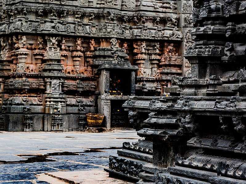
On the southern bank of the Krishna river is a temple the town Srisailam is known for. The Mallikarjuna Swamy Temple, is the most celebrated temple of the town and finds it roots in the sixth century, when it was built by King Harihara Raya of Vijayanagar. According to legend, Goddess Parvati cursed sage Bringi to stand, as he only worshipped Lord Shiva. Lord Shiva, after consoling the goddess, gave him a third leg, so that he could stand more comfortably. Visitors can find the idol of sage Bringi standing on three legs here as well as idols of Nandi, Sahasralinga and Nataraja. The walls and pillars of the temples are also adorned by beautiful carvings and sculptures. One of the most beautiful temples of the town, this is the one sacred structure, located on the Nallamala hills, that should not be missed.
At the highest point of Srisailam, referred to as Sikharam, one finds a temple dedicated to the Sikhareswara Swamy, watching over the landscape and a pristine Krishna river flowing below. Sikhareswara Swamy is one of the forms of Lord Shiva and is believed to possess the power to free his devotees from their sins. Here, at this abode of the Lord of Sikharam, you can find some of the most beautiful views in the area with another temple dedicated to Lord Ganesha.
A recent addition to the temples of Srisailam is the Hemareddy Mallamma temple located close to the Mallikarjuna Swamy temple. The temple has an ashram next to it.

Located amidst beautiful surroundings, the Sakshi Ganapati temple is a small little shrine dedicated to Lord Ganesha. Devotees believe that Lord Ganesha knows who visits the Mallikarjuna Jyotirlinga and keeps a record and shows it to Lord Shiva. Hence, devotees visit this temple first to register their visit before visiting any other temple in Srisailam. There is a modest climb of 10 steps to reach the sanctum of this temple which is nestled amongst dense woods.
A modest temple, housing a Shiva Linga, the Hathakesvara temple tends to be one of the most frequently visited temples, by locals. The temple is said to at the same place as where Sri Adi Sankaracharya, created one of his philosophical texts.
Situated at a distance of 20 km from Srisailam, the Ista Kameswari temple is dedicated to an avatar of Goddess Parvati, Goddess Istakameswari. Dating back to somewhere between the 8th and 10th centuries, the temple is based in the middle of a lush green forest and boasts of stunning landscape. Known to have a striking architecture and beautiful designs, the temple is located inside the folds of a cave that makes it all the more interesting and unique. Other than the surroundings, the highlight of the temple is the idol of Goddess Kameswari which is said to have a super soft texture although it is made in hard steel. It is believed that the Devi can grant any wish to the devotees if they visit it even once.
Srisalam is known for its devotion towards Lord Shiva, and a rocky bank of this river has in each of its rocks, believed to be an image of Lord Shiva. The belief also grants the bank its name, Lingala Gattu.

The setting of Akkamahadevi caves around 10 kilometres away from Srisailam in Telangana is a natural wonder. Located right across the Krishna river, the caves are a natural formation that has been in existence for more than a million years amidst the Eastern Ghats. With its naturally formed arch at the entrance which stands without any support of any kind, the main attraction is the deep-lying Shivalinga inside the extensive maze of pathways. The lingam is a popular religious shrine, dedicated to Lord Shiva and has attracted tourists and pilgrims for centuries. The hills of the Nallamala range across the ghat section offer serene, picturesque views of the vista around, en route the Akkamahadevi Caves. The Krishna river is the sole route available to access the caves, and the small but scenic journey is said to be well worth the effort. Private and public boat operators undertake these short trips from the small piece of habited land, close to Srisailam. Bordered by the towering Nallamala hills on all sides, ride may last up to an hour or so. The caves are named after the Kannada poetess, saint and philosopher of the 12th century, Akka Mahadevi. She is said to have performed penance and offered prayers inside the caves to the naturally existing Shivalingam deep inside the cave formation.
As the river Krishna turns down hill, it is called Patala Ganga or the underground Ganges with a certain spirituality in the air. One can also try the enjoyable ropeway car ride and look down at the majestic river and lush green beauty all around. The starting point of the ropeway is near the Srisailam Mallikarjuna temple. The ropeway is open from 6 am to 5:30 pm while you can enjoy boating from 9 am to 5 pm daily. Cost of the both the ropeway and the boating is INR 50 for adults and INR 35 for children.

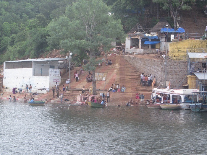
One of the main centres of attraction for the town, the Srisailam dam is also one of the 12th largest hydroelectric projects in India. A blend of uninterrupted natural beauty and engineering genius, the Srisailam dam emerges out of the verdant greenery of the Nallamala Hills to mark its presence and is built across the verve of the Krishna river and nestled in a deep canyon, surrounded by forests and sceneries, finding a home in the sound of gushing and falling water. The road up to the dam is a scenic beauty too, and the view of the Srisailam Dam is a sight to behold. The foundation of the dam was laid down in 1960 and was completed in 1981 with the second phase undertaken in 1987 to convert the site into a multipurpose project with a capacity to generate additional 770mw of power.The imposing structure of the dam is perched at a massive height of 300 metres and the edifice itself is 145 metres in height and 512 metres in length. One of the best things to do around the Srisailam dam is to spend some quality time as one looks over to the gurgling waters of the Krishna. The view from the top of the dam is an astonishing sight, especially when the water is released and one can see the might of its flow. Visitors can also explore the dam using the ropeway and taking a boat ride on the Krishna river. The dam is open from 6 am to 5 pm daily and entry is free.

Octopus View Point is a view point is located 5 km before Domalpenta and offers amazing views of the adjoining forests, enchanting gorges and the mesmerising backwaters of the Krishna river. It is so named because of Krishna river down below looks like an octopus spread between the hillocks. It provides a spectacular bird’s eye view of the entire valley below. In addition to that, there is a regular safari tour conducted by the reserve that is the major highlight of the place.
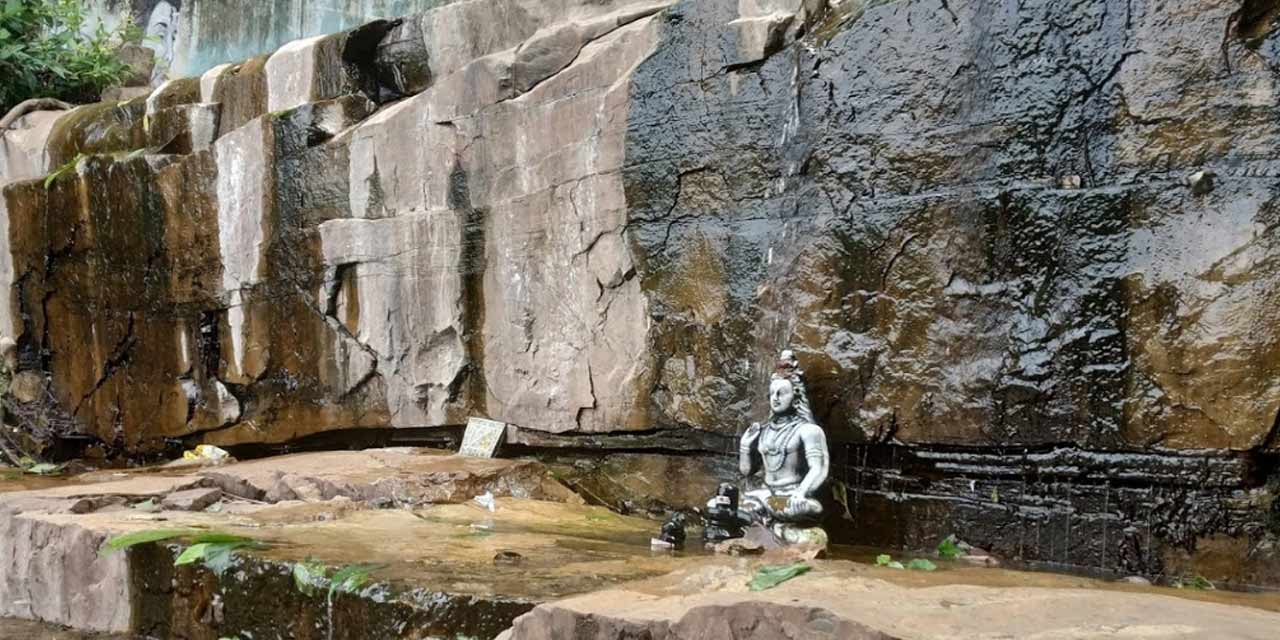
Paladhara Panchadara is a beautiful scenic spot that is located around 4 km from Srisailam and can be reached by a flight of stairs that leads to an infusion of several streams. The gurgling of streams along with the beauteous natural environment surrounding the place makes it the perfect spot to reflect and unwind. It also holds significant religious importance as the name of the central stream Paladhara Panchadara is derived from the Hindu God Lord Shiva. It is believed that the stream was named after the one originating from Lord Shiva’s forehead with pala meaning forehead and dhara meaning stream. It is believed that Sri Adi Shankaracharya stayed here in the 8th century while he was meditating. He created his renowned masterpiece Sivanandalahari right here as well as the Bhramaramba Ashtaka where he praises Goddess Bhramaramba. Paladhara Panchadara is open between 9 am and 5 pm daily.
Find yourself fascinated as you witness instances of the livelihoods and cultures of the tribes of Andhra Pradesh at the Chenchu Lakshmi Museum. Also, honey collected by the tribes and packaged by the state government is also available at the museum for sale and is a true specialty to take back home.
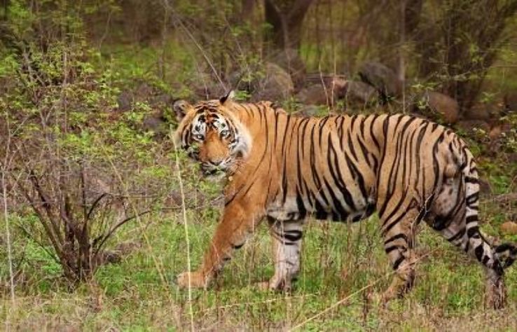
The Srisailam Tiger Reserve occupies a total area of 3,568 acres, making it one of the largest tiger reserves in India. The Srisailam Dam and Nagarjunasagar Dam are also located in the reserve area. Apart from tigers, one can spot other animals like the leopard, sloth bear, dhol, Indian pangolin, chital, sambar deer, chevrotain, blackbuck, chinkara, and chowsingha. There are other reptiles and amphibians also found in this area including crocodile, Indian python, king cobra and Indian peafowl.
One also finds a number of crocodiles in the down waters of Srisailam Dam, where a breeding programme, supported by the local government is being carried out.

Cumbum
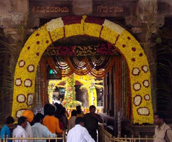
Cumbum town is widely popular for the age-old man-made lake here. Also called Gundlakamma Lake, it is built on the rivulet of the same name upon Nallamalai Hills. The lake is 7km long and has a width of 3.5km. Cumbum Lake is touted as one of the oldest man-made lakes in Asia. It has its roots in history as it was built by Gajapati rulers of Odisha back in 15th century and was later modified and its anicut was built by Varadharajamma, Vijayanagar princess and wife of King Krishnadevaraya back in the 17th century. Details provided from the Imperial Gazette of India shows that in those days, the lake supplied its water to 10,300 acres of land for the purpose of irrigation which is why it earned the reputation of being the second-largest irrigation tank in Asia. That Cumbum had been under the reign of Mughal rulers are proven by the inscriptions here in the town. There are two, particularly, which belong to the early 18th century. One refers to the death of Sheriff Khaja Muhammad, who was the Qiladar of the Cumbum fort during the reign of Aurangzeb and the other refers to Muhammad Sahib, the governor of Cumbum during the reign of Muhammad Shah. Since the lake is located in the lap of Nallamala forest, one can visit the nearby temples and waterfalls too. The Srisailam temple is nearby as well as the Bhairavakona waterfalls which includes the monolith Bhairavakons temple dedicated to Lord Shiva and Goddess Parvati as well as eight smaller temples carved out from the hills.

Nellore
Nellore is a beautiful city lying on the banks of the river Penna and was known as Vikrama Simhapuri in ancient times. There are various theories linked to the origin of its name. A mythological story from the Sthala Purana depicts a lingam in the form of a stone under a nelli tree. The place gradually became Nelli-ooru with Nelli standing for the emblica tree and ooru generally means place to the present day Nellore. Another explanation is that the town got its name from the extensive cultivation of paddy in and around it with Nell meaning paddy and ur meaning town. The Gazetteer of the Nellore District considers the latter the more plausible etymology. Nellore had been under the rule of Mauryas, Satavahanas, Cholas, Pallavas, Pandyas, Kharavela of Chedi dynasty, Kakatiyas, Eastern Gangas of Kalinga Empire, Vijayanagara Empire, Arcot Nawabs and other dynasties. The town was under the rule of Ashoka of the Mauryan dynasty in the 3rd century BC and then conquered by the rulers of the Pallava dynasty and was under their rule till the 6th century AD, subsequently the Chola rulers ruled Nellore for a long period of time. The Telugu Cholas met their decline in the 13th century. Tamil inscriptions indicate that it formed part of Chola kingdom till their decline in the 13th century and later became a part of Kakatiyas, Vijayanagara Empire, Sultanate of Golconda, Mughal Empire and Arcot Nawabdom. In the 18th century, Nellore was taken over by the British from the Arcot Nawabs and was part of the Madras Presidency. The city had an important role in the emergence of the Telugu language and the formation of the state of Andhra Pradesh. Potti Sriramulu, who fasted until death for the formation of Andhra Pradesh, hailed from Nellore. The town is known for its rich agriculture and has been an exporter of rice, sugarcane and cane based products, prawns, shrimps and a varied set of crops. It is the 6th most populous city in Andhra Pradesh.
Also known as Ramathirdham, the Ramalingeswara temple is located 30 km from Nellore city with the presiding deities being Lord Shiva and Goddess Kamakshamma. Devotees also visit temple to worship Lord Vigneswara and Subhramanya. An ancient temple, it serves as a magnificent architectural grandeur and is easily accessible from Vellore via a state highway.

Dedicated to Lord Vishnu, the Narasimhaswamy temple lies about 13 km from the centre of the town with Lord Vishnu being worshipped in this temple in his fourth incarnation. Also referred to as Sri Vedagiri Lakshmi Narasimha Swamy temple, the place holds several myths. The Santhana Vriksha located within the temple premises is said to bless the childless devotees while the Kondi Kasuli Hundi is considered to rid the sufferers from venomous snake and scorpion bites. A much smaller place of worship dedicated to Adi Lakshmi is also can be spotted above the main temple. The temple is open daily from 4:30 am to 12:30 pm and then again from 3 to 7:30 pm.

Lying on the banks of Pennar river, the Ranganatha temple is one of the most revered temples of Nellore. The temple is great religious significance and is considered to be the oldest temples of the area. The temple is also known for its beautiful architecture and exquisite carving and houses seven gold pots adorned with huge mirrors within the temple premises. The Addala Mandapam or minor hall situated within the complex is famous for its intricate inlay work. It is also a major part of the temple being the place where the idol of the presiding deity of the temple, Lord Sri Ranganathswamy is enshrined. The temple is open daily from 6 am to 12 noon and then from 2 to 9 pm.
Barah Shaheed Dargah is a mausoleum located very close to the sea in Sulurpet. The place was established in the honor of 12 martyrs and there is a common belief that those who visit here to pay their respects, have all their wishes fulfilled. The dargah is a sight to behold during the time of Moharram when a festival called Rottela Panduga is held for three days.

Mypadu Beach is a mesmerising beach with pristine seawater and golden brown sand and is located about 25 km from Nellore on the coast of the Bay of Bengal. One can take a long peaceful stroll across the beach or sit in the sand, contemplate about life or just absorb the beauty of the location. Open from 5 am to 6 pm and managed by the Andhra Pradesh Tourism Development Corporation, this beautiful beach serves as an ideal place to relax and connect with nature.

Renowned for being one of the most significant pelican habitats in southeast Asia, the Nelapattu Bird Sanctuary is every bird watcher’s dream location. This sanctuary is located just near the village of Nelapattu and is spread over a total area of about 459 hectares. The sanctuary is also a crucial breeding site for the spot-billed pelicans and is also home to significant plant areas like the Barringtonia swamp forests and the southern dry evergreen scrub. Other than the spot-billed pelican, the sanctuary is an important breeding ground for other birds as well, such as white ibis, openbill stork, night heron and little cormorant. In all, 189 different species of birds can be found here, of which 50 species are migratory. These migratory birds include the common teal, shoveler, spot-bill duck, grey heron, black-winged stilt, and garganey gadwall. It was declared as a sanctuary in 1997 and is open daily from 9 am to 5 pm. Entry fee for adults is INR 2 and for children, is INR 1 while foreigners pay INR 400/ If heavy vehicles need to enter, it will cost INR 100 and INR 50 for jeep and cars while it is INR 10 for two or three wheelers. If visitors plan on taking photographs, the camera fww is INR 50.

Patu Ru is a small village lying about 10 km from Nellore and is a perfect place to stock up on handicrafts and handloom sarees for which the village is renowned for. The village is settles between the triangle formed by Kovuru, Damarmadugu and Kovuru.
Our next part will see us exploring Andhra Pradesh’s judicial capital Kurnool, Gandikota, Tadipatri, Anantapur and the temple town of Puttaparthi
