
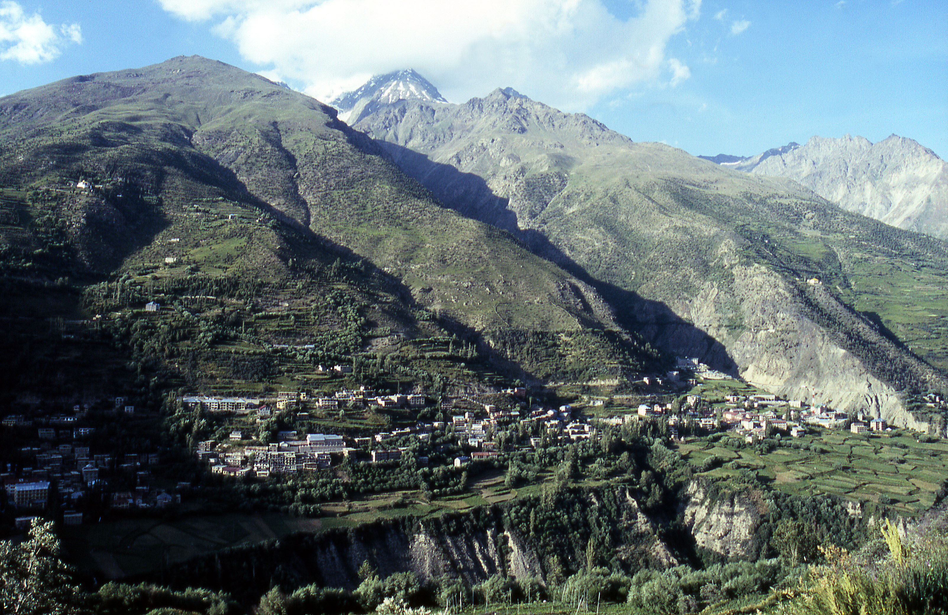
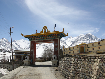
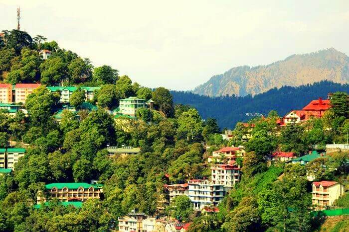
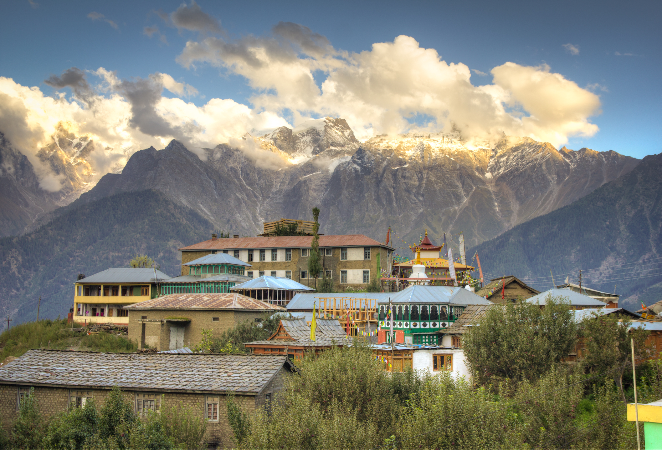
Keylong
Nestled between the Lahaul and Spiti district, Keylong is perfect for a getaway away from the tourists towns of the state. Due to the dry cold weather, Keylong does not have a lot of greenery, but the snow-covered mountains covered with mist are picturesque. Situated at an altitude of 3080 meters, the tiny hamlet is generally a stop-over for visitors travelling in the region. The small town is cut off from the outside world from November to mid-May due to heavy snowfall at Rohtang Pass. It is mandatory to get a permit from the Tourist Development Council Manali to travel to Keylong mostly because travel to Rohtang pass is restricted and to get to Keylong, one needs to cross the pass. Located 8 km from Keylong, the Kardhang Monastery is situated amidst mountains with a stunning architecture. The monastery houses a library with ancient Buddhist texts and weapons dating back to the 12th and 13th centuries. The Barachaa La Pass where Barachaa translates to pass with crossroads on summit in English offers spectacular views of the mountains and is also where three rivers namely; Chandra, Bhaga and Yunam originate. The Shashur monastery which is located at an elevation of 600 meters, sits atop a hill 3 km away from Keylong. The walls of this monastery are embellished with beautiful paintings of the 84 siddhas of Buddhism and the best time to visit is during the months of June and July because of the annual festival celebrated. The Tayul Monastery is located 6 km from Keylong. Tayul which translates to the chosen place is home to a grand library that houses thousands of ancient texts as well as a huge statue of Guru Padmasambhava. Believed to be the lake of the Sun God, Suraj Tal is situated amidst snow-covered mountains at an elevation of 4960 meters. At a distance of 24 km from Keylong, Darcha is the place to go if you plan to camp. Located at an elevation of 3360 meters, Darcha is a huge camping site. The ancient fort at Gondla was built in the 18th century and is situated 18 km from Keylong. The fort is eight stories high with intricate architecture and is located the Chandra River. The Lahaul and Spiti Tribal Museum is rich in artefacts relating to the culture of this area with many beautifully woven clothes, old masks, utensils, handmade carpets, treasures and archaeological artefacts. A tranquil lake, Deepak Tal provides scenic beauty with fresh, cold and clear water.
Pin Valley National Park
Set amidst semi-frozen rivers in the Pin Valley, the Pin Valley National Park is situated in the Cold Desert Biosphere Reserve in the Lahaul and Spiti district. The park was established in 1987 as a part of the Great Himalayan National Park Conservation Area. The elevation of the park ranges from about 3,500 metres near Ka Dogri to more than 6,000 metres at its pinnacle. Steeped in historical and present day Buddhist Tibetan culture, the area has many Tibetan Buddhist influences, evident architecturally in monasteries and stupas, and in the daily living of its residents.
One of of its kind, the Pin Valley National Park is home to rare species of the Himalayan snow leopard and their prey, the Ibex. The National Park is famous for its incredible trek which require special inner line permits which is required for any travel within 40 km of the Tibetan border and foreign nationals are not allowed inside the park. The park’s core zone is sprawled across an area of 675 sq km while its buffer zone is extended over almost 1150 sq km. Due to the park’s high altitude and extreme temperatures, vegetation density is sparse, comprising mainly of alpine trees and groves of Himalayan cedar or deodars. In summer, rare birds like the Himalayan snowcock, the chukar partridge, the snow partridge and the snow finch. Because of its snow-laden unexplored higher spots and slopes, the park forms a natural habitat for a number of endangered animals including the snow leopard and the Siberian ibex. Twenty-two rare and endangered medicinal plant species have been discovered in and around the National Park, distributed over 10 different habitat types.
The Pin Valley National Park is the place for those who like trekking in rough terrains. There are two routes with the first one called the Summer Route which is open from July to October, and the second one called the Winter Route, open from March to December. Mid- May to September is considered to be the best time to visit Pin Valley National Park, since the region around the park receives heavy snowfall in winter.

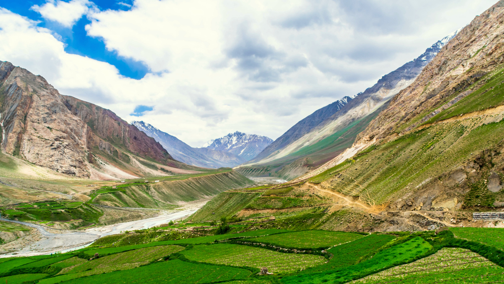
Spiti valley
A cold desert mountain valley located high in the Himalayas in the north-eastern part of the state, Spiti Valley’s name comes from the fact it lies between India and Tibet with Spiti meaning the middle land. Scantily populated, Spiti is an adventure lover’s paradise, with a number of trekking trails that tourists can choose from. Bordered on all sides by the Himalayas, Spiti Valley, is at an altitude of 12,500 feet above sea level, and gets just about 250 days of sunshine in the year, making it one of the coldest places in the country. With the thick Himalayan snow cutting Spiti off from the rest of the country for around 6 months a year, the summer months are the only time Spiti is directly accessible via motorway. All treks in the valley begin from Kaza, Spiti’s capital, which is a tranquil getaway on the plains of the Spiti river and is bound by mountains covered in snow, rivers and streams and picturesque barren landscape with scattered patches of green. Kaza is divided in to two parts, old and new Kaza, accommodating government offices and the king’s palace respectively. Locals follow the Vajrayana Buddhism similar to that found in the Tibet and Ladakh regions. The valley and surrounding region is one of the least populated regions in India and is the gateway to the northernmost reaches of the country.

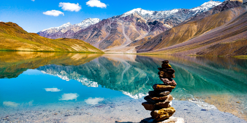
Chandratal Lake is often referred to as one of the most beautiful lakes and is located at an altitude of about 4300 on the Samudra Tapu plateau which overlooks the Chandra River. The name Chandra Taal which means lake of the moon comes from its crescent shape. This lake is also one of two high-altitude wetlands that have been designated as Ramsar sites. Legend has that the Chandratal Lake lies in the vicinity of the place from where Lotf Indra’s chariot picked up Yudhishthira, the oldest of Pandava brothers. The colour of this lake keeps changing from red in the morning to orange and blue to to emerald green as the day ends. Vast stretches of green meadows house the best camping sites with an array of wildflowers during spring. The trek from Batal to Chandratal can be quite a tedious trail, but the views make the trek worth it. The Chandratal Lake trek goes through a scenic route with a panoramic view of the Lahaul range with snow clad peaks of Minar, Talagiri, Tara Pahar and Mulkila, all of which are over 6000 meters.

Five km from the Dhankar monastery lies the Dhankar lake on the other side of the mountain which can be reached in about an hour after following a well marked trail from the monastery. When the sky changes colour, it reflects the colours on the crystal clear lake making it the perfect place to contemplate on life.

The Kunzum Pass or Kunzum La, as it is called by locals, is one of the highest motorable mountain passes in India, located at an altitude of 4,551m above mean sea level and serves as a gateway to Spiti valley. It lies on the eastern Kunzum Range and offers an incredible 360-degree view of the Bara – Shigri Glacier, the second longest glacier in the world, a jaw-dropping vista of Chandrabhaga Range and a spectacular views of the Spiti valley. A 15 km trek to Chandrataal lake starts from the pass and it is believed that visitors have to stop at the temple of Goddess Kunzum Devi, on their way to the pass, to pay their respects and seek blessing to travel safely. The tradition is to take a complete circle of the temple in one’s vehicle.
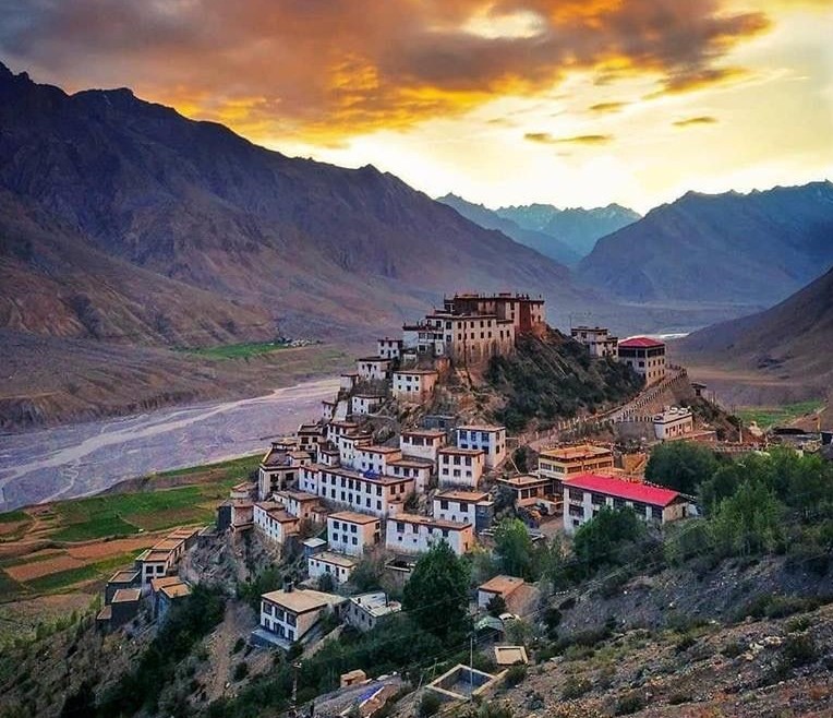
Located at an altitude of 4,166 m, the Key Monastery is very close to the Spiti river and is also known as the Kye or Ki Monastery, it is believed to have been founded by Dromton, a student of Atisha in the 11th century. Over a thousand years old, the monastery is the largest in Spiti Valley and doubles up as a religious training centre with about 300 lamas receiving their education here. As a result of the repeated attacks on the monastery, it was rebuilt multiple times making the monastery look more like a fort. The walls of the monastery are adorned with beautiful murals and paintings and marked by narrow corridors that lead to low rooms. The monastery has three floors with the first floor is used for storage and is mostly underground. The ground floor of the monastery houses the assembly hall and has cells for the monks. A richly painted room, Tangyur never fails to capture one’s attention. Thangkas, manuscripts, stucco images and wind instruments can be found within the monastery as well as an extensive collection of weapons on display.

Also refered to as Dankhar, Drangkhar or Dhangkar Gompa, the Dhankar Monastery is situated at an altitude of 12,774 feet and is perched unbelievably on the edge of a cliff and offers a panoramic view of the Spiti valley. Built one thousand years ago on a 1000 feet high mountain and overlooking the confluence of the Spiti and Pin rivers, Dhankar Monastery is listed as one of the world’s 100 most endangered monuments. Besides enchanting views, the gompa has the statue of Vairochana or Dhayan Buddha which consists of four figures seated back to back and a small museum with scriptures and murals. Below the monastery is the village of Shichilling where there is a new monastery which houses about 150 monks belonging to the Gelug school of Tibetan Buddhism. Dhankar was the traditional capital of the Spiti Valley kingdom during the 17th century and has some features from the 12th century.

Standing tall at a height of 10,000 feet, the Tabo Monastery is one of the oldest monasteries located in the Tabo village of Spiti Valley and is the oldest monastery in India that has been functioning continuously since its inception. It is second only to the Tholing Gompa in Tiber and was built by the Buddhist king, Yeshe-O. It is known as the Ajanta of the Himalayas, because of the walls of the monastery which are decorated with fascinating murals and ancient paintings, much like the Ajanta Caves in Maharashtra. Today it has been taken over by the Archeological Survey of India. The walls of the monastery are 3 feet wide and encompass 9 temples, 4 stupas, 23 chortens, a monk’s chamber and an extension which contains the nun’s chamber. The temples house a priceless collection of manuscripts, thangkas, stuccos and frescoes with the walls decorated with murals that depict the ancient tales of the Mahayana Buddhist pantheon. A four-fold figure of Vairocana, one of the five spiritual sons of Abibuddha rests in the Initiation Temple with many other life-sized statues of gods and demons and holy scriptures.

The Shashur Monastery is a three-storied monastery of the Drugpa sect, located about 40 km from Manali. The literal meaning of Shashur in the local language is blue pines, as blue pine trees can be found around the monastery. Since the monastery is perched at an elevation of 600 m above the valley, the views of the river, mountains and Keylong town are amazing. Built in the 17th century, following the Mandala concept of a square having four gates with a circle in the centre, the prayer rooms of the monastery are bedecked with large thangkas and wall paintings.

Also known as the Guru Ghantal Gompa, the Gandhola Monastery, is located around 20 kms from Keylong. Perched on the Tupchiling village hilltop, at the confluence of the Chandra and Bagha rivers, the monastery is the oldest monastery in the Lahaul region, founded by Padma Sambhava around 800 years back. It is famous for its wooden idols, which stand out from the clay idols found in all other monasteries.

Located in the Bhaga Valley of Spiti, the Tayul Monastery houses the biggest statue of Padma Sambhava which is 12 ft. tall, in his two manifestations of Singhmukha and Vajravarahi. Situated around 6 kms from Keylong, the Tayul Gompa also has a hundred million mani wheels, which are supposed to open the minds of visitors to the compassion of Lord and are said to turn themselves on auspicious occasions.

The Tangyud Monastery is located in the Komic village of Spiti Valley at 4520 metres and is one of the highest altitude gompas in India. Also known as Sakya Tangyud Monastery, it is situated on the periphery of the Kibber Wildlife Sanctuary. Sitting on the edge of a deep canyon, the monastery is built in the form of a fortified castle. Adorned with red ochre and white vertical stripes, with a slanting mud wall, it gives the appearance of being taller than it actually is and is one of the only two monasteries belonging to the Sakya sect left in Spiti Valley.

The Kardang Monastery is located in Kardang village on the banks of Bhaga river at an altitude of 3500 metres and is situated on a ridge below Rangcha Peak, facing the town of Keylong. Said to be more than 900 years old, the monastery is famous for its alluring architecture, religious significance and phenomenal collection of murals, thangkas, paintings and instruments. There are about thirty monks and nuns at Kardang Monastery who have equal rights and permission to marry. They spend the summer with their families and return to the monastery in winter. Every year in the months of June and July, an annual Chaam dance is also organised where monks are dressed in dramatic masks and headgears. The architectural style of Kardang Monastery is typical of the Lahaul and Spiti district. The highlights of the monastery include a large golden Buddha statue, ancient colourful frescoes and murals and a library of Buddhist literature including the Kagyu and Tangyur scriptures in the Bhotia or Sherpa language. There are strips of paper on which the sacred mantra ‘Om Mani Padme Hum’ is written one million times. 103 volumes of the Kangyur are kept in the library with 64 tantra books on various subjects. The monastery also houses a 4-foot high silver chorten or shrine in the first room which has the skull and ashes of Lama Norbu. To the right of it are statues of Padmasambhava and Tara Devi, and in the back, one of Tagden Shakyashree, a guru of Lama Kunga. The second room is the main Prayer Hall with an eleven-headed statue of Avalokitesvara. On a high pedestal at the right are some of Lama Norbu’s castoff garments and with a skull in front. In the third room is a six-foot wooden prayer wheel with a brass bell on it.
Located in the Pin Valley, around 10 km from Attargo and 3 km from Gulling, the Kungri Monastery is the second oldest monastery in Spiti valley and the only one following the Nyingmapa Buddhism tradition, the oldest order of Tibetan Buddhism. The Kungri Monastery has gorgeous silk paintings of Buddhist deities adorning the inner walls and during June-July, one can witness the performance of the Devil Dance or Chham.
The Trilokinath Temple, also known as Sri Trilokinathji Temple, is located in Trilokinath village. The temple is the only place in the world where both Hindus and Buddhists worship together. The diety is considered as Lord Shiva by Hindus while the Buddhists see it as Arya Avalokiteshwar. Trilokinath, another name for Lord Shiva, means the Lord of three worlds. It is believed that the Trilokinath Temple was originally a Buddhist monastery. Located at an altitude of 2760 metres, the white-painted temple used to be called Tunda Vihar, which is is the ancient name of the temple. The temple has a curvilinear stone tower or shikhara which has a distinctive amlka on its top and is made in a traditional wooden pagoda style and decorated with Tibetan prayer flags. As one enter the temple, there is a courtyard with a small white shrine with a granite lingam and a Nandi bull in the middle and a large Buddhist prayer wheel. Past the courtyard, in a room around the original shrine, a Hindu priest and a lama sit.

Komic Village, situated at a height of 4275m is a location where fossils are found, but one should not be tempted to to that as the buying and transporting of fossils is not legal. The village also owns a small monastery where women are not allowed during prayers.

Situated in the Sutlej river valley near the India- Tibet border, Tashigang is a quaint little village which is also the highest point in the Spiti Valley. Perched at an altitude of 4650 m, the village has just over four homes with a meagre population of 6 families and around 40 people in all. Tashigang’s claim to fame is that it has the highest polling booth in the world as well as a beautiful lake.
Kibber, also known as Kyibar, is a small village located at an altitude of 4270 metres and is surrounded by picturesque mountains and barren landscapes, Kibber boasts of being the highest inhabited village with a motorable road and is famous for the local monastery and the Kibber Wildlife Sanctuary. Established in 1992, Kibber Wildlife Sanctuary is spread over an area of 1400 sq k and harbours rare species of flora and fauna. Around forty snow leopards have been discovered here. The area is rich in rare and endangered medicinal plant species used in the production of traditional medicines and cosmetics. Local operators and homestays organize excursions and treks to the sanctuary.

Also known as Mummy Village, Gue is a small village which has the mummy of a monk placed inside a tomb. As per carbon dating, the mummy is 500 to 600 years old and is dressed in silk robes and placed in a squatting position. It was discovered in 1975.
Sarchu, which lies in the border of Ladakh and Himachal Pradesh is usually chosen as an overnight stop for people who travel along the Leh-Manali Highway. Located at an altitude of 4,290 metres, A majour trading point on the Silk Route, Sarchu is also called as Sir Bhum Chun and lies between the Baralacha La mountains in the south and Lachulung La in the north. The camping site on the Himalayan mountain range has many semi-permanent camps which are run between May and October.

Narkanda
Surrounded by forests and woodlands, Narkanda is a quaint little town popular for skiing in winters. Situated at a height of 9000 feet, this town is known for its natural beauty and beautiful apple orchards and is surrounded by tropical forests and majestic hills. Narkanda also has various trekking routes and a beautiful hill, Hatu Nag can be trekked and from where one gets a panoramic view of the town below. Soaring at a height of nearly 12,000 feet above sea level, the Hatu Peak is the highest peak in the Shimla district, which is surrounded by mountains and covered in a dense green forest comprising a varied population of deodar, fir, spruce, cedar and blue pine. The Hatu Mata Temple rests atop the hill on Hatu Peak and is dedicated to Mandodari, the wife of King Ravana. There is a small stove like formation that sits right next to the temple, believed to have been used by the Pandava brothers to cook their food during their exile. The trek to the peak is not very rigorous and is a one-way hike of 7 km. The Tannu Jubbar Lake is encircled with trees all around and is an ideal picnic spot. Located 7 km form Narkanda is the Mahamaya Temple, dedicated to Goddess Kali which is set amidst beautiful surroundings. Many years back, Satyanand Stokes started cultivating apples in Narkanda and kickstarted the town’s economy. This because the Stokes Farm and today the area is known for these apple orchards and.
Mashroba
Connected to the state capital of Shimla by the historic Hindustan-Tibet Road built by Lord Dalhousie in 1850, Mashobra is notable for housing one of the two Presidential retreats in India, with the other being the Rashtrapati Nilayam in Secunderabad. The President of India visits Mashobra at least once every year, and during this time their core office shifts to the retreat at Chharabra, in Mashobra. The building housing the retreat is a completely wooden structure originally constructed in 1850. Also known as the quieter Shimla, Mashobra stands at a height of about 7700 feet and is the perfect alternative for those looking for a peaceful little hill-station. Asia’s largest watersheds supplying water to Shimla, the Reserve Forest Sanctuary is a must visit not just for this reason, but also for the lush coniferous cover surrounding it and also because it is a birdwatcher’s delight. Prior permission to visit the sanctuary is needed as it is a reserved area. A spectacular picnic spot which was previously a villa of an Italian photographer Chevalier who named it after his hometown, Craignano is located at a height of about 7700 feet and flanked by streams as well as pines and oaks on all sides and is constructed out of wood. The Shali Tibba hill at an altitude of 2873 m is located in Khatnol village, 35 km from Shimla and is also known as 360 because of the 360 view from the peak of Kufri, Fagu, Shimla and Narkanda Hills. The mountain peak has a temple dedicated to Goddess Bhimakali. Originally built as a residence of Lord Kitchener of, the Wildflowers is said to have been a favourite retreat of Lord Ripon. However, it burned down in 1993 and a new Wildflower building was built as a hotel there in a joint venture between the Himachal Pradesh government and the Oberoi group of hotels. If one is a big fan of exploring little known traditions and festivals, then visiting the Mahasu Peak in the month of May should be on the list. The festival, known as Mahasu Jatara, falls on the third Tuesday of May and celebrates the shifting of the idol of the chief deity Lord Mahasu.
Kinnaur
Located on the Indo-Tibet border, Kinnaur is situated at a distance of 235 km from Shimla and hosts views of the Zanskar Valley and the snow-draped Dhauladar range. Also known as the land of God, Kinnaur’s claim to fame is the Kinnaur Kailash with the shivaling, the representation of Lord Shiva and the mesmerising rock formations which change colours several times a day. Opened to outsiders in 1989, there are old Buddhist monasteries and temples here and the district is well known for its delicious apples, Chilgoza, handlooms and handicrafts materials. Kinnaur lies on the northeast corner of the state bordering Tibet to the east and has three high mountains ranges, Zanskar and Himalayas that enclose valleys of Satluj, Spiti, Baspa and their tributaries. The slopes are covered with thick wood, orchards, fields and hamlets. At the peak of the Kinnaur Kailash mountain is a natural rock Shivling. The old Hindustan-Tibet Road passes through the valley along the banks of river Sutlej and finally enters Tibet at Shipki La pass. Kinnaur also has historical cultural links with Ngari Prefecture of the Tibetan Autonomous Region.
A favourite for Buddhist pilgrims because of the three temples of Galdang Chhodkar, Dunguir and Kangyur and an old monastery dedicated to local deity Tangtashu, Lippa has the Taiti stream flowing by. Reckong Peo also known as Peo lies in the middle of the Himalayas at a height of 2,300 metres. Also known as Rirang, Ribba gets its name by adding ri, meaning chilgoza, which Kinnaur is known for and rang, meaning mountain peak. The area is famous for its grape orchards and grape distilled alcohols and the innumerable trees with edible pines. Moorang is known for its apricot orchards and the fort built by the Pandavas on the banks of the Sutlej river.
Sarahan
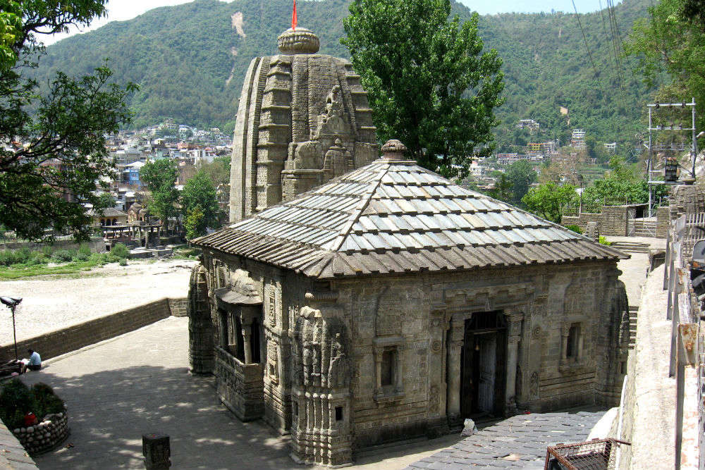
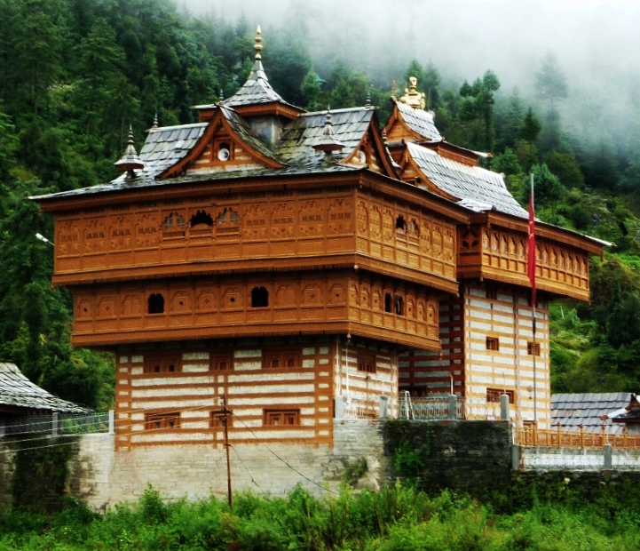
A small hamlet, Sarahan is known as the gateway to Kinnaur and is located near the Sutlej River Valley and the Indo Tibetan road, at an altitude of 2165 m below sea level. Famous for the never-ending apple orchards, dense emerald pine and deodar forests, gushing streams, wildflower fields rustic settings, terraced farms and slate-roofed houses, the village is a sight to behold. The village is famous for the Bhimadevi Temple, dedicated to the mother goddess Bhimakali, who was the presiding deity of the rulers of the former Bushahr State. One of the 51 Shakti Peethas, it is believed the temple is built at the place where Sati’s ears fell. The temple is built in the traditional Kinnauri manner with a touch of a unique Tibetan architecture and has three complexes, the first two which were built in the 12th century and the third in 1920. The three complexes are dedicated to Lord Raghunathji, Patal Bhairva Ji and Narsinghji, though Devi Kali is the principle deity and has a separate shrine. The exterior boost of wood works and the interior is full of intricate carvings. During Dussehra, grand prayers and animal sacrifices are offered to the Goddess. The Sarahan Bird Park
is located close to the Bhimkali Temple and houses the famous state bird Jujurana as well as other local birds and is closed during the summer as it is the breeding season. Located 50 km from Sarahan, Bhabha Valley is a beautiful valley running along the Bhaba river with an amazing landscape filled with the lake and alpine meadows and also is the starting point for the trek route to Pin Valley in Spiti. The Shrikhand Peak has a temple dedicated to Lord Shiva near the peak which, according to legend is where the Lord meditated. Hawa Ghar is a quaint little sitting area built below the canopy of tall trees and offers a phenomenal view of the high peaks and deep valleys. Sarahan was the summer capital of the Bushahr kings and the Bushahr Palace is situated adjacent to the Bhimkali temple. It is generally not open for public visits, though the garden and some parts may be accessible at times. The royal family does not live here now and only visits during Durga puja.

Sangla Valley
Named after a beautilful village of the same name, the Sangla Valley is bound by mountain slopes, sprawling evergreen forests, snow covered peaks, red apples orchard and cherry trees. The Baspa river also makes its way through the place and is famous for trout fishing. The Sangla Meadow is a lush green meadow spotted with mud patches and a magnificent backdrop of the snow covered Himalayas. Also referred to as Sangla Kanda, this is a must-see place when in the valley. The Baspa river, a photographer’s delight is an ideal place to fish rainbow and brown trout, camp and trek. Dedicated to Lord Jagas, the Bering Nag temple is another must-vissit and not just for its The Brelengi Gompa was established in 1992 to perform the Kalachakra ceremony by the Mahabodhi Society. Chitkul is said to be the last inhabited village within the Indian on the old Indo-Tibetan road. Situated at the height of 3450 meters, the village is located at a distance of 28 km from Sangla and has an exquisite landscape of breathtaking beauty with orchids, mountains, meadows, huge rocks, river, jungle, and grasslands. The village is sparsely populated. On the way to , about 22 km from Chitkul, one will also pass through the Rakcham village, commonly known as the model village in the region. A quaint village Rakcham is located in the Baspa Valley by the Baspa river, an important tributary of the Sutlej. Sangla is also famous for Tibetan proucts made of wood which can be found at the Tibetan Wood Carving Centre. Situated almost 8 km from Sangla, the Basteri village is where one can shop some interesting local handicrafts like handmade shawls and the Kinnauri caps.
Kalpa
A small village, Kalpa is known for its apple orchards. Local Kinnauris follow a syncretism of Hinduism and Buddhism and many temples in Kalpa are dedicated to both Hindu and Buddhist gods and goddesses. The village is known for its ancient temples and the Sutlej river flows below through deep gorges and bordered by chilgoza pine forests. An inner line permit is needed to continue upwards to the Spiti Valley. Also visible from here is the shivling rock on the Kailash mountain that changes its color at different points in the day. A perfect example of Kinnauri craftsmanship, the Narayan-Nagini temple is constructed in the traditional Tibetan pagoda style and situated on the top of a hill at Chini village. The Hu-Bu-Lan-Kar monastery was founded by Rinchensang-po who lived between 950 and 1055. Also known as Koshtampi, Kothi is important as a religious place due to the temple of the Hindu God Bhairon Baba and that of Goddess Chandika who is believed to slash the head of a demon who helped the takur of Chini in ruling Sairag and brought bliss to the town. She is believed to bestow magical boons to her devotees. The Kinnar Kailasha which is locally known as Kinner Kailash is a mountain at a height of 4800 meters and is considered sacred by both Hindu and Buddhist Kinnauris and is sometimes confused with the Mount Kailash in Tibet. There is a monolithic pillar or Shivling at an altitude of around 4800 meters which is supposed to change colour at different times of the day. As the name suggest, Suicide Point has a dangerous trench and vertical slopes with the walk to this point taking one through apple orchards. The Sapni Fort is near the Sapni village and is seven stories high. There is a temple dedicated to Goddess Kali on the fifth floor. Two buildings of this fort were constructed by King Padam Singh of Rampur, one of them being his queen’s tower. The fort also displays impressive woodwork and carvings on window frames and doors. Converted into a temple today, the Kamru Fort is dedicated to Goddess Kamakhya Devi. The fort comprises of a wooden balcony with a large idol of the goddess is placed on the third floor and a huge image of Lord Buddha in the main gate. The Roghi village is a small village about six to seven km Kalpa, famous for its simple lifestyle and customs of the region.

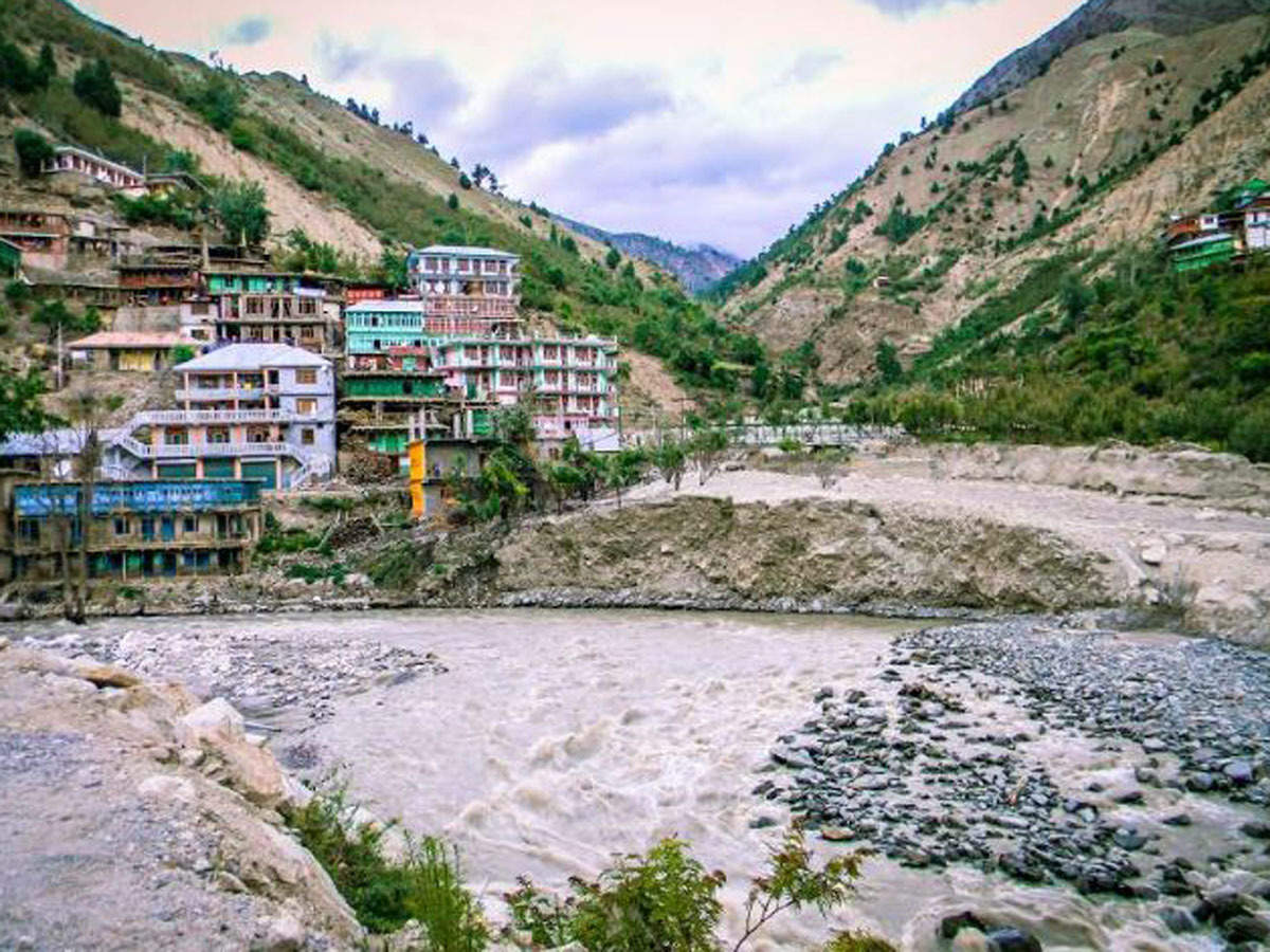
Pangi Valley
Pangi valley is a serene, quiet area inhabited by tribal people at 7,000 ft to 11,000 ft above sea level and is underdeveloped and hidden away with uneven roads and scanty resources. The valley is surrounded by white peaked mountain tops and rugged roads. The Saach Pass, a mountain pass of 14500 ft, is open during the months of June and October as it snows heavily during other months. The shrine of Det Nag in Killar is a popular tourist destination. Others include Killar, a hamlet located in a narrow gorge of the Chenab river, which is the headquarters of the Pangi subdivision; Dharwas which is the largest village in the valley; Shour, a bridge that swings over an icy cold river; Mindhal Basan Devi temple, a beautiful temple dedicated to the deity Mindhal Devi, among many others. The valley is closed for tourists for most of the year due to heavy snowfall and avalanches. The uniqueness and remoteness of the valley makes for a culture that is unique and not found anywhere else. Killar is the administrative headquarters of sorts of the valley located deep in a narrow gauge of the Chenab river. Killar also acts as an appropriate base for those trekking to Kishtwar through the Zanskar Valley. The main attraction is the Det Nag temple, dedicated to Lord Shiva. The Mindhal Devi temple located about 12 km away from Killar in the Mindhal village is famous for its wood carvings. Dharwas is the largest village found in the valley, located very close to Killar and falls on a trekking trail. It is known for its beautiful natural water spring, Tilmili that provides water rich in minerals and it is said that the King of Chamba would drink from this spring. Situated on the right bank of the Chenab river and the Chandrabhaga, Cherry Bungalow is a rest house which makes for a brilliant checkpoint while travelling in the valley. The Saichu nallah one of the major tributaries of the Chandrabhaga meets the river here with a small temple dedicated to Lord Shiva. The Parmar valley is located at an altitude of about 3,000 ft above sea level and comprises of a cluster of three villages namely Kumar, Parmar and Parmar Bhatori. The village of Parmar Bhatori has a Buddhist Gompa, and above the village are beautiful and lush expanses of green pastures. Despite the valley being secluded and still relatively underdeveloped, it is a beautiful place for a short trip of a few days.
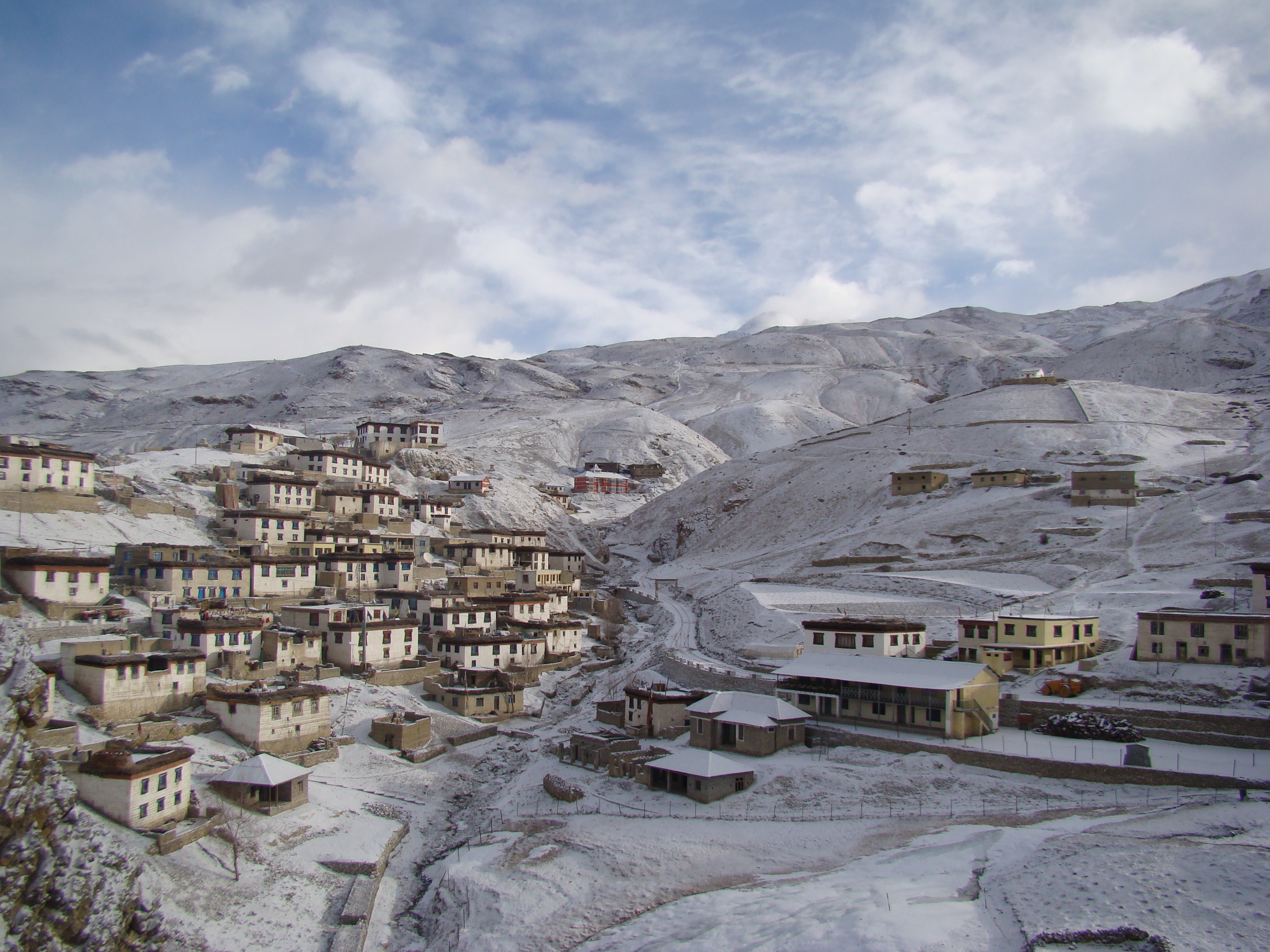
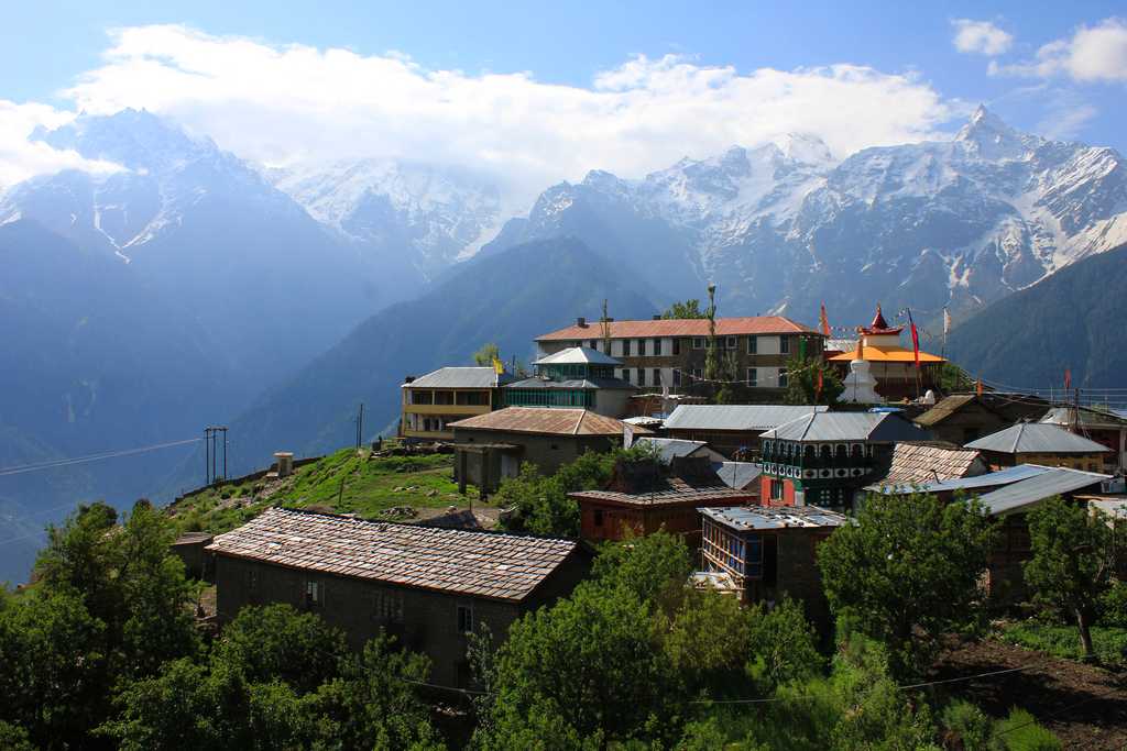
Nako
Located 3,600 metres above sea level, Nako is the most significant village in the district on the eastern end. Also known as the land of the Fairytales because it is surrounded by the greenery home to many rare species, the village is home to the Nako Lake, Buddhist temples and Rakham. Near the lake, one can also find the footprints of Lord Padmasambhava, who is believed to have meditated at the spot for many years. Because it is close to the Tibetan border, travellers need inner line permits to travel to the region and foreigners need permissions to stay overnight in any part of the village. When viewed from afar, the village seems as if it is submerged in a lake. What is unusual about the lake is the waterfall in which the water that flows appears as a milky liquid which is because the water is full of snow, and according to legends, it is the realm of fairies. The footprints of these fairies and other demigods can still be found in one of the caves near the lake. The Nako Monastery dates back to the 11th century and comprises of four large and spacious halls, the oldest known as Dukhong. The monastery complex also houses a shrine which is dedicated to Purgyal, a local deity attributed to be the spirit of the mountain. The Lipa- Asrang Sanctuary, renowned for its diverse plants is spread over an area of about 30.89 sq km. The variety of flora found in protection here includes dry coniferous forest, dry alpine scrub, dwarf juniper scrub and others. Visitors need permission to enter the sanctuary. The Chango gompa, located just a few kilometres away from the Nako monastery, is famous for its prayer wheel which is more than 500 years old and is made up of yak skin. To enter the village, one has to pay INR 150 per person for the entry permit.
And with this we come to the end of our series on the beautiful and bewitching state of Himachal Pradesh. With so much beauty waiting to be discovered, I can’t wait for things to get back to normal so that I can make a trip there, preferably during winter!
