
The Aminidivi group of islands, consisting of Androth, Amini, Kadmat, Kiltan, Chetlath, and Bitra came under the rule of Tipu Sultan in 1787 and passed to British control after the Third Anglo-Mysore War and were attached to South Canara. The rest of the islands came under the suzerainty of the Arakkal family of Cannanore in return for a payment of annual tribute which the British took over for nonpayment of arrears and were attached to the Malabar district of the Madras Presidency during the British Raj. On 1 November 1956, during the reorganization of Indian states, the Lakshadweep islands were separated from Malabar district and organised into a separate union territory for administrative purposes with the new territory called Laccadive, Minicoy, and Amindivi Islands before adopting the name Lakshadweep Islands on 1 November 1973.
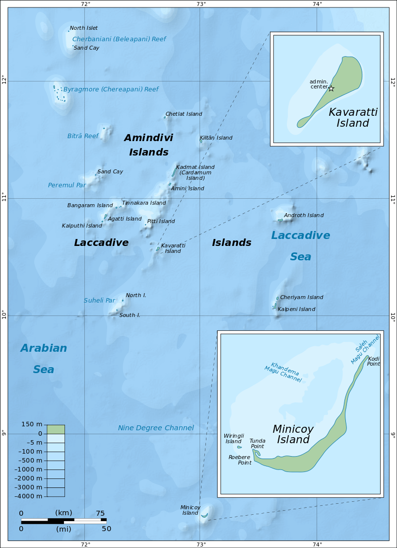
The Aminidivi subgroup of islands consisting of Amini, Keltan, Chetlat, Kadamat, Bitra, and Perumal Par and the Laccadive subgroup of islands which comprises mainly of Androth, Kalpeni, Kavaratti, Pitti, and Suheli Par, have a submarine connection between them through Pitti Bank. Together with Minicoy Island, a lonely atoll located at the southern end of the 200-km-broad Nine Degree Channel, they form the Coral Islands of India in the Arabian Sea. All these islands have been built up by corals and have fringing coral reefs very close to their shores. Two banks further north, Angria Bank and Adas Bank are not considered part of the group. The Aminidivi Islands, are one of the three island subgroups in Lakshadweep and is the northern group of the Lakshadweep, separated from the Laccadive Islands subgroup roughly by the 11th parallel north. The islands of Amini, Kiltan, Chetlat, Kadmat and Bitra are inhabited with Islam being the main religion of the islanders. The islands were inhabited from ancient times by people of nearby Kerala to which were added later people of Arab descent. In the mid 16th century all the inhabited islands of the Lakshadweep were conferred as the jagir or estate of the ruling family of the Cannanore or Arakkal Kingdom by the Chirakkal or Kolattiri Raja in order to grant them protection from the Portuguese. In the latter quarter of the 18th century, the islands of the Amindivi group revolted owing to the rigours of the enforcement of the monopoly of the coir rope trade and following the uprising, the northern islands put themselves under the rule of the Kingdom of Mysore in 1784, then ruled by Tippu Sultan. The southern group of the Cannanore Islands, however, remained loyal to the Arakkal Kingdom. In 1792, as a consequence of the Third Anglo-Mysore War and the defeat of Tippu Sultan, the Amindivi Islands came under the East India Company rule following the treaty of Srirangapatna.

Cora Divh, also called Coradeeve or Little Bassas de Pedro Bank, is a submerged bank or sunken atoll and is the third largest feature of Lakshadweep, after Bassas de Pedro and Sesostris Bank. It is also the northernmost feature. Cora Divh has no emergent cays or islands and is covered by sand, coral rubble and broken shells.
Sesostris Bank is a submerged bank or sunken atoll and is the second largest feature of Lakshadweep and one of the northernmost features, after Cora Divh and Bassas de Pedro and is named after the steam frigate INS Sesostris of the Indian Navy.

Bassas de Pedro, also known as Manjappar or Pedro Bank, is a submerged bank or sunken atoll which is the largest feature of Lakshadweep. It is also one of the northernmost features, second only to Cora Divh and is in the shape of an arch open to the east with widths ranging from 15 km in the north to 33 km in the south. Its southern end is 63 km east of North Cay of Cherbaniani Reef, the closest land feature. There are no emergent cays or islands and the bank is steep-to, smooth with minor undulations in topography, and composed of sand, shells, and decayed coral. The water on the bank is not discolored.
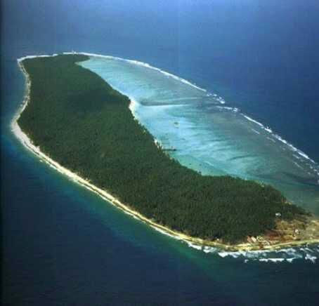
Cherbaniani Reef, also known as Beleapani Reef and Valiyapanniyam in Malayalam, is a coral atoll and is the northwesternmost feature of Lakshadweep with a roughly oval shape. The 14 km long coral reef that encloses the lagoon has three small uninhabited islands on it composed of accumulated coral sand, shingle, cuttle-bones and sea shells. There are many land hermit crabs under the boulders and among the detritus and the atoll used to be a breeding ground for pelagic birds, including the sooty tern and brown noddy, formerly found in great numbers.
North Islet has a small mosque built and maintained by local fishermen from Bitra, Chetlat, Kiltan and Agatti islands. The fishermen came here and camp for fishing during the period between both monsoons. Lakshadweep islanders from Chetlat and Bitra sometimes visit the islands to collect guano for the gardens of the inhabited islands, gathering eggs, dumping garbage and disturbing the nestlings of pelagic birds in the process. The beaches are strewn with marine litter.
Byramgore Reef, also known as Chereapani Reef is a coral atoll whose northern part is submerged. There are a few sandbanks on the reefs, but little land is above the surface at high tide. The atoll is visited by birds, including the lesser crested tern and greater crested tern.
Chetlat Island is a coral island whose local history says that islanders were cruelly treated by Portuguese seafarers in the past. Coir twisting was the traditional occupation of the islanders and average Chetlat coir used to be equal to first-class coir of the other islands in Lakshadweep. One of the populated islands of the archipelago, Chetlat is located 37 km to the northwest of Kiltan Island and the reef and lagoon are located to the west of the island with a small scale yearly growing sand spit on the northern point of the island. Chetlat is the sole inhabited island of the township of Chetlat Island and the inhabitants are engaged in very small scale farming and fishing which are mainly for the island consumption. There is a small jetty on the west coast and a helipad on southpoint.

Bitra, also known as Bitra Par, is a coral atoll where prior to the 20th century, islanders from Kiltan and Chetlat visited to collect the eggs of birds breeding there. Until 1945, when a woman from Chetlat made this island her home, there were no attempts to settle this island permanently. There is a small shrine dedicated to an old Arab saint by the name of Malik Mulla who was buried on the island which has become a pilgrimage site. The atoll of Bitra encompasses two islands, the main Bitra Island is located at the northern end of the coral reef and the small south cay is located on the southern part. Bitra is the smallest of the populated islands of Lakshadweep with the main island having a small jetty on the south shore and a helipad on the westpoint. The inhabitants on the island are engaged in very small scale farming and fishing which are mainly for the island consumption.
Kiltan or Kilthan Island is a coral island which was settled during the early periods of immigration to the Lakshadweep islands, part of an international trade route between the Persian Gulf and Ceylon. It is also home of the Sufi saint Shaikh Ahmed Naqshabanthi. Kiltan is one of the populated islands of Lakshadweep with the reef and lagoon located to the west of the island and is also crossed by the 73rd meridian east through its landmark known as Kulikkara which is a tomb of a Lady venerated by the natives.

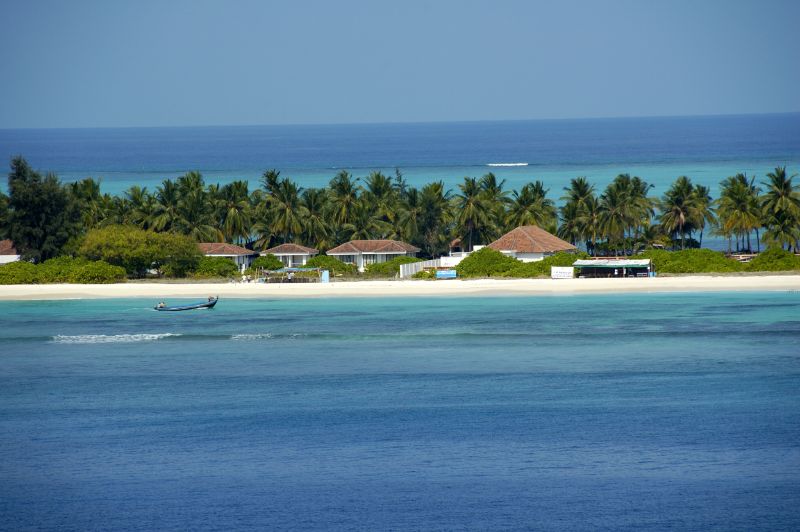
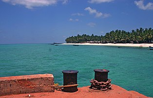
Kadmat Island, also known as Cardamom Island, is a coral island with seagrass and marine turtles which nest here. The island has been notified as a marine protected area for ensuring the conservation of the island’s animals, plants, organism and other resources. The only inhabited village on the island is Kadmat, which has fishing as the main economic activity with agriculture limited to 5% of the land area. Tourism is allowed even for non-Indians and the attractions are kayaking, snorkeling and leisure trips by a glass-bottomed boat for scuba diving. Kadmat Island is the central most island of the archipelago and is in the shape of a tear drop and is the longest island in the Amindivi group. There is an airport on nearby Agatti Island, in which flights operate from Cochin. From Agatti, it is a two and half hours boat ride to Kadmat. Ferry services also operate from Cochin on the coast of Kerala but involves a journey of 16 hours.
In 1960, a hoard of coins were unearthed and examined, revealing that the island has been inhabited since at least the year 200 and the island is known to have traded with the Romans, as in 1948 a Roman coin was found in a quarry on the island. Kadmat Island offers a host of activities to its guests which is why it is thronged by thousands of tourists every year. Some of the most popular activities and things to do on the island are scuba diving, kayaking, snorkelling and paragliding. One can also just sit and sun soak and admire the beautiful surroundings and use some of the many amazing spa and massage services available here.
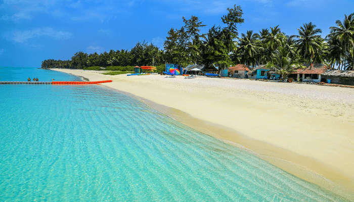
Spread over 100 metres and surrounded by beautiful blue lagoon and shimmery white sand, Kadmat Beach is not only one of the most gorgeous beaches in the region but also, one of the most visited. One can relax on a hammock, sunbathe on the shores, stroll along the seashare and watch some of its many mesmerising sunrises and sunsets. Kayaking is another popular activity here due to the pristine nature, mostly untouched and uncommercialised with crystal clear waters. There are glass bottom boats available which can be hired for the views.
The best time to visit Kadmat Island is during the winters and early summers, between the months of October and May when there are cool sea breezes blowing, and the climate is pleasant. It is better to avoid summers and monsoons due to the high heat and humidity.
Elikalpeni Bank is a submerged bank or sunken atoll and is the easternmost geographic feature of the archipelago.
Perumal Par, also known as Peremul Par, is an uninhabited coral atoll very similar in appearance to the Cherbaniani Reef further north. It has a large lagoon devoid of islands in the encircling reef, except for 3 small sandy islets located at the eastern area. Terns of different species visit this atoll. There is some damage to the corals caused by Acanthaster planci crown-of-thorns starfish that was observed in the 1990s. Its surrounding waters are a good fishing area for baitfish and is often visited by fishermen from the inhabited islands nearby as well as tourists from the nearby Bangaram Island resort who often make excursions to this lonely atoll.

Amini Island was one of the first islands in the archipelago to be inhabited. The artisans on this island are known for making walking sticks out of coconut shells and tortoise shells as well as carved stone and coral motifs. The channel between Amini Island and Cardamom Island is safe and deep. The Amini Island Light is shown on the south point of the island. The island is oval with the long axis oriented northeast-southwest. It lies at the northeastern extremity of Pitti Bank, 42 km from the small, uninhabited Pitti Island which is not to be confused with the Pitti Islet of Kalpeni Atoll, which is located at the opposite southwestern extremity of the bank. Pitti Bank, also oriented along a northeast-southwest axis, is 49 km long and may be considered a largely submerged and sunken atoll with just the two islands Amini and Pitti remaining at its opposite ends. Kadmat island, although just 5 km northeast of Amini Island, is separated from it by a deep channel and thus forms a separate geographical unit.
In the next part, we will explore the Laccadive subgroup of the Lakshwadweep archipelago.
