
Earlier this month, I finally reached India in my walk from my home in Singapore to my childhood home in Mumbai. For those who are new to this page, I am using the distance between Singapore to Mumbai as an impetus to walk my daily steps and I track these steps on a Google map. Since my first state in India is the state of Manipur, I decided to start this year with the same state.
One of India’s easternmost states, Manipur lies in Northeast India, bound by the states of Nagaland to the north, Mizoram to the south and Assam to the west. It also borders two regions of Myanmar, the Sagaing Region to the east and the Chin State to the south. Manipur has been at the crossroads of Asian economic and cultural exchange for more than 2,500 years and has long connected the Indian subcontinent and Central Asia to Southeast Asia, China, East Asia, Siberia, Micronesia, and Polynesia, enabling the migration of people, culture and religions. Manipur’s state bird is the Nongin, its state flower is the Siroi Lily and the Phoebe hainesiana or Uningthou, which is native to the state is a state tree.
The word Manipur is made up of two Sanskrit words Maṇi, which means jewel and Purǝ, which means land or place and so Manipur is translated as the jewelled land. Manipur is mentioned in historic texts as Kangleipak or Meeteileipak. The name Manipur was adopted in the 18th century by officials during the reign of Meidingu Pamheiba. Neighbouring cultures each had differing names for Manipur and its people. The Shan or Pong called the area Cassay, the Burmese called it Kathe and the Assamese called it Meklee. In the first treaty between the British East India Company and Meidingu Chingthangkhomba or Bhagyachandra, signed in 1762, the kingdom was referred to as Meckley. Bhagyachandra and his successors issued coins engraved with Manipureshwar or Lord of Manipur, and the British discarded the name Meckley. The term Kanglei, the meaning of Manipur or Kangleipak, is used to refer to items associated with the state while the term Manipuri is a recently given name. The Meitei ethnic group represents around 53% of the population of Manipur, followed by various Naga tribes at 24% and various Kuki-Zo tribes at 16%. Meiteilon or Manipuri is the state’s official language and tribals constitute about 41% of the state population.
The history of Manipur Meities is chronicled in the Puyas or Puwaris which are stories about the forefathers in the archaic Meitei script, comparable to the Thai script. By the medieval period, marriage alliances between royal families of the Manipur kingdom, the Ahom kingdom of Assam and Burma had become common. Medieval era Manipur manuscripts discovered in the 20th century, particularly the Puya, provide evidence that Hindus from the Indian subcontinent had married Manipur royalty by at least the 14th century. Another manuscript suggests that Muslims arrived in Manipur in the 17th century, from what is now Bangladesh, during the reign of Meidingu Khagemba. Ancient Manipuri mythology is indigenous to the kingdom and is also related to the local religion or Sanamahism, which includes thousands of Gods and Goddesses.

In 1891, after the defeat of the Meiteis by the British in the Anglo-Manipuri war of Khongjom, the sovereignty of Manipur which it had maintained for more than three millenniums, was lost. In 1926, it became a part of the Pakokku Hill Tracts districts of British Burma until 4 January 1947. During the British colonial rule, Manipur was a princely state with the people of Manipur pressing for democracy between 1917 and 1939. By the late 1930s, the state of Manipur negotiated with the British administration its preference to continue to be part of India, rather than become part of Burma, which was being separated from India. These negotiations were cut short with the outbreak of World War II in 1939 and on 11 August 1947, Maharaja Budhachandra, the King of Manipur signed an Instrument of Accession, joining the Indian Union and on 21 September 1949, he signed a merger agreement, merging the kingdom into India. During World War II, Manipur was the scene of many fierce battles between the Japanese invaders and the British Indian forces. The Japanese were beaten back before they could enter Imphal and this was one of the turning points of the overall war in South Asia. Manipur’s merger with India was later disputed by groups in Manipur, as having been completed without consensus and under duress and has resulted in a 50-year insurgency in the state for independence from India, as well as in repeated episodes of violence among ethnic groups in the state.
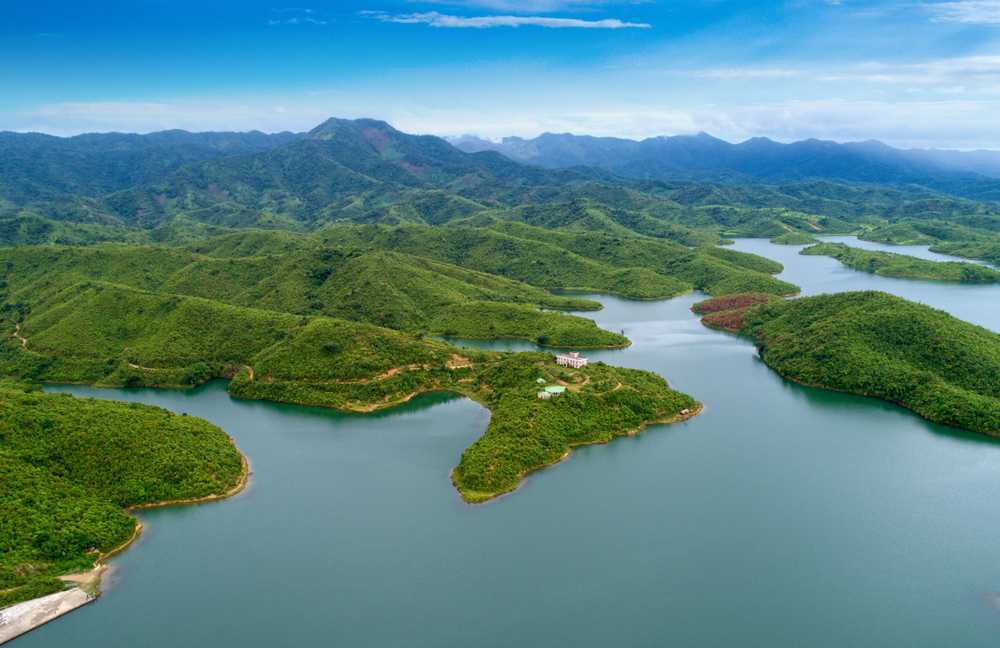
Imphal, the state’s capital lies in an oval-shaped valley surrounded by blue mountains, at an elevation of 790 metres above sea level with the slope of the valley from north to south. The mountain ranges create a moderated climate, preventing the cold winds from the north from reaching the valley and barring cyclonic storms. The state has four major river basins: the Barak River Basin or the Barak Valley to the west, the Manipur River Basin in central Manipur, the Yu River Basin in the east, and a portion of the Lanye River Basin in the north. Manipur may be characterised as two distinct physical regions: an outlying area of rugged hills and narrow valleys, and the inner area of flat plain, with all associated landforms with both areas distinct in physical features and conspicuous in flora and fauna. The tourist season in the state is from October to February when it is often sunny without being hot and humid.

The Manipuri dance is also known as Jagoi and is one of the major Indian classical dance forms, named after the state of Manipur. It is particularly known for its Hindu Vaishnavism themes, and exquisite performances of the love-inspired dance drama of Radha-Krishna called Raslila. However, the dance is also performed to themes related to Shaivism, Shaktism and regional deities such as Umang Lai during Lai Haraoba. The roots of Manipur dance, as with all classical Indian dances, is the ancient Hindu Sanskrit text Natya Shastra, but with influences from the culture fusion between India and Southeast Asia, East Asia, Siberia, Micronesia and Polynesia.

Imphal
Manipur’s capital Imphal was initially ruled by Kin Khaba and then ruled by the Pakhangba leaders when the Ningthouja tribe originated. The Ningthouja tribe quickly expanded and dominated the region in politics and war. The Kangla Palace was built by King Khagemba and his son Khunjaoba and was later destroyed by the British during the Anglo-Manipur War. During the reign of Maharaja Bhagyachandra, there were several Burmese invasions. However, the kingdom survived with the help of Maharaj Gambhir Singh.
Imphal remained peaceful until 1891 when internal differences in the royal family resulted in the 1891 Anglo-Manipur War, which the British won. The Battle of Imphal took place between March and July 1944, during World War II between the Japanese and Allied forces when the Japanese invaded Imphal to destroy the Allied forces and then invade India. But they were defeated and forced to retreat and the attack made the British realise the militarily strategic position of Imphal.
Also known as the Kangla Fort, the Kangla Palace is an old palace situated today on the west bank of the Imphal river and served as the royal palace of the former Manipur Kingdom and King Pakhangba. Originally located on both the banks of the river, today it is located in the centre of Imphal and the ruins of the palace are surrounded by a moat. Kangla which means dry land in old Meetei was the traditional seat of the Meetei rulers of Manipur. The fort is one of the oldest existing forts in the world, with its earliest record of existence dating back to 1445 BC.
One of the holiest places for the Manipuris, Kangla is a pilgrimage centre and it is believed that Lord Pakhangba resides under Kangla and ruled the Kingdom of Manipur as well as the universe. It is also believed that there are 360 important holy and sacred places in Kangla, some of which include the Nungjeng Pukhri, a sacred pond believed to be the abode of Lord Pakhangba located to the north-west of the Uttra where religious rituals are performed. Nunggoibi is another sacred place of worship of the Goddess of War and is where the Huyein Lalu Chanba ritual was performed whenever a King emerged victorious in battle. Manglen is where all the Kings of Manipur are cremated and is believed to have been developed by Maharaj Garibaniwaz in 1738. The Kangla Men Surung is where the kings performed their coronation ceremony and it is believed that the King’s ability to rule would depend on the results of the ceremony. Located to the south-eastern corner is the Wangbaren where ceremonies in connection with flood and natural calamities were performed.

Amongst the various ruins in the Kangla are the ruins of the citadel built-in 1611 during the reign of King Khagemba. The citadel enclosure had three entrances, two on the western side and one on the southern side. The Uttra was the ancestral coronation hall of the kings which also housed the coronation hall and was destroyed during the Second World War. Two huge Kangla Sha or dragons made of brick used to stand in front of the Uttra but just beyond the flight of steps leading to the Uttra on either side of the path leading to the Uttra. The dragon was the emblem of the Meiteis and was originally said to be erected by the Chinese war captives. The Kangla Sha were blown to pieces by the British after their occupation of the fort in 1891. The fort has been open to the public since 2003. Bihu Loukon is an ancient star-shaped mud fort situated in Maklang.
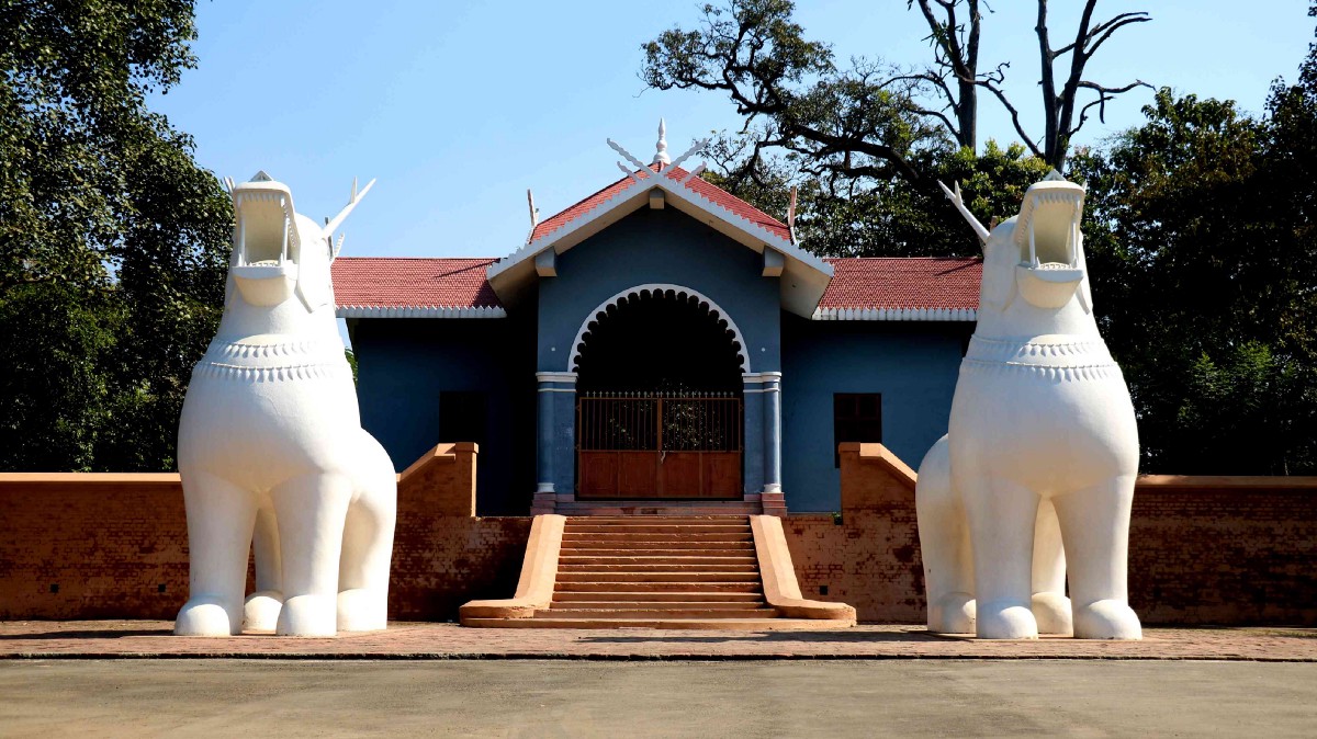
Langthabal, located about 9 km south of Imphal is most famous for its magnificent temples and historical monuments. Situated tall on a hill Langthabal is popularly known for the relics of the historical palace, traditional dwellings and architecturally complex and accomplished temples of importance. The place was created as a corridor surrounded by symmetric jackfruit and pine plantations. The hill overlooks the Manipur University campus which presents a mesmerizing view of the surroundings. The historic Langthabal Palace which was a listed monument does not seem like a protected area, instead, it has become a vast dumping ground. The Memorial site of Maharaj Gambhir Singh at Langthabal located at Manipur University campus was once the Royal Palace during the reign of Maharaj Gambhir Singh, the then Maharaja of Manipur. The complex also includes the Memorial House or Meetei Yumjao symbolising the shrine of the king.

The Ima Keithel or the Mother’s Market or Nupi Keithel or the Women’s Market is a market run exclusively by women. A popular tourist attraction, over the years, it has shifted its location within the city and is currently located in Khawairaband Bazaar. The market was established in the 16th century, following the imposition of the labour system, lallup-kaba in 1533 and hosts around 5,000 to 6,000 women vendors who sell a variety of products such as vegetables, fruits, textiles, toys fish, spices and utensils and is the largest all-women market in Asia. Lallup-kaba was a forced labour system in Manipur that required male members of the Meitei community to work in distant lands or to serve in the army and as a result of which, women had to support their households by cultivating their fields or weaving textiles and then selling the products on improvised markets which then led to the formation of the organized Ima Keithel. The Hapta Kangjeibung is the world’s oldest polo ground and is also the main venue of Manipur’s Sangai festival which takes place between 21 and 30 November annually.

The highest mud dam in the world, the Singda Dam is located 16 km from Imphal and is a popular picnic spot, with its scenic views, and relative calm. A multipurpose project constructed on the Singda river in Kangchup, it is one of the highest earthen dams in India. The dam is 490 m in length and 60 m in height and provides drinking water and irrigation to the greater Imphal area.
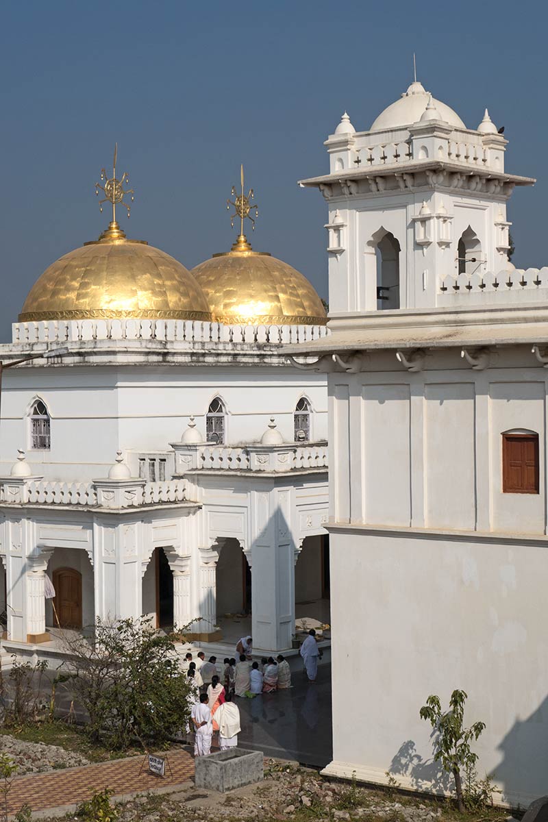
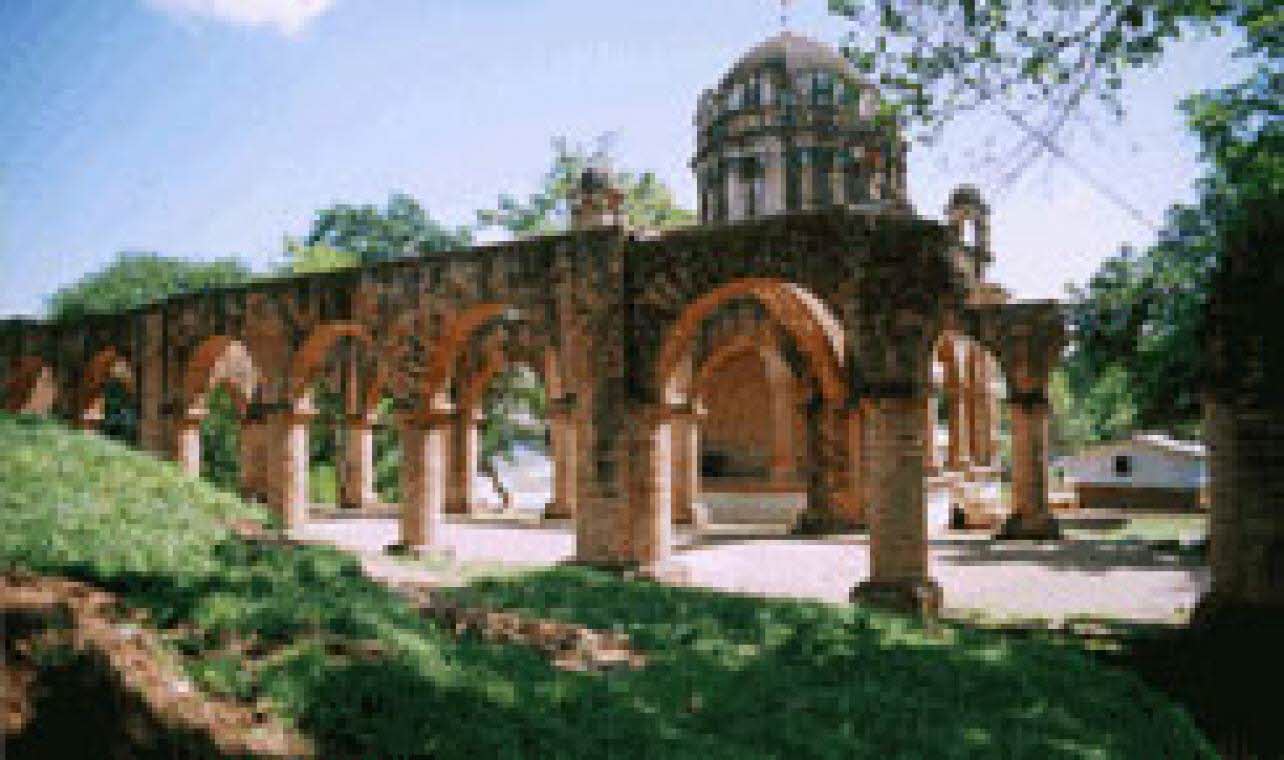
Situated near the royal palace, the Shri Govindji Temple is one of the major temples in the state constructed in the Nagara style of architecture. The largest Hindu Vaishnavite temple in the state, it is dedicated to Shree Govindajee or Lord Krishna along with various other Gods and Goddesses. The temple is also where the classic Manipuri form of dance style was first performed, dedicated to Shri Govindajee. Within the complex, the temple of Shree or Shree Govindajee was originally built in 1846, during the reign of Maharaj Nara Singh. It was severely damaged in the earthquake of 1868 with the idols of Radha Govinda damaged when parts of the temple collapsed. The temple was reconstructed by Maharaj Chandrakriti with two domes and a raised congregation hall.

The Sanamahi Temple or the Sanamahi Sanglen is a temple dedicated to Lord Lainingthou Sanamahi, the supreme deity of Sanamahism. It is located in the Sanakhwa Yaima Kollup near the Kangla Palace and is one of the oldest temples in Asia. It is often confused with the Sanamahi Kiyong Temple, situated on the hilltop of the Nongmaiching Hill and is one of the largest Kanglei temples in the state. It was reconstructed during the reign of King Kulachandra Singh in 1891 and is built in a Gothic style of architecture with a flying advance on the southern side and raised in an octagonal base. Today, the temple is located on the grounds of the 1st Manipur Rifles. The temple is a major tourist attraction as well as a religious destination of the followers of Sanamahism, including the Meitei, Kabui, Bishnupriya Manipuri people and Zeliangrong people.

The Shri Radha Raman Temple is situated at Kanchipur The Gopinath Mandir is the second-largest Hindu temple in Manipur and is also a grand premise for the performance of the great Manipuri dance, dedicated to Shri Gopinath. The Hiyangthang Lairembi Temple Complex is noted for its annual Durga Puja festival in September or October.

The 11 m tall Shaheed Minar is situated in the centre of the Bir Tirkendrajit Park and is a memorial for those who died against the British while fighting in the Meitei Revolt of 1891. The Imphal War Cemetery with over 1600 graves of those who died fighting World War II is maintained by the Commonwealth War Graves Commission is located in Dewlahland, 10 km away from Imphal International Airport. Red Hill or Maibam Lokpa Ching is a hillock and a memorial site of the World War II Battle of Imphal. It was here that a war took place between the Allied and Japanese troops. The Japan War Memorial Complex is also present in the foothills, constructed by the Government of Japan.

Specialised in the preservation and breeding of rare species, the Manipur Zoological Gardens, with its lush greenery and calm atmosphere is surrounded by hills and was established in 1976. The Manipur State Museum was set up in 1969 and caters to various categories of artefacts such as ethnology, archaeology, natural history and painting. It showcases articles owned by the Manipuri rulers.

Known as the lungs of the Imphal Valley, the Langol Reserved Forest is known for its wide-stretching area spanning in the Imphal valley. It is also famous for the sacred groves preserved since ancient times. The Langol Lairembi Temple and the Langol Ningthou Temple are sacred sites for those who follow the Sanamahi Faith.

Vaishnavite dance forms are popular in India for the religious and spiritual elements present in the songs as well as in performance. These dances have been established with devotional connotations which focus on the relationship between Lord Krishna and his beloved Radha. In terms of pure devotion, India has a long history of Vaishnavite rituals.
https://www.indianetzone.com/40/vaishnavite_dance_forms.htm