
Maenam Wildlife Sanctuary
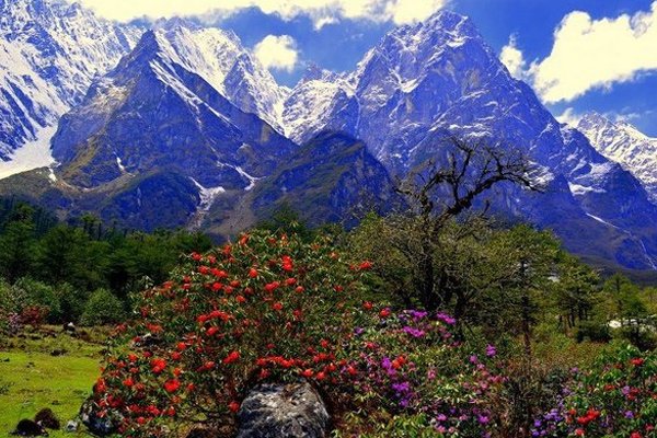
Maenam Wildlife Sanctuary is a wildlife reserve in South Sikkim covering an area of around 35 sq km. The meaning of Maenam-la translates to a treasure-house of medicine, and the sanctuary is rich in several plants of medicinal value. Established in 1987, Maenam wildlife sanctuary lies 65 km south of the state capital of Gangtok and is a popular tourist destination.
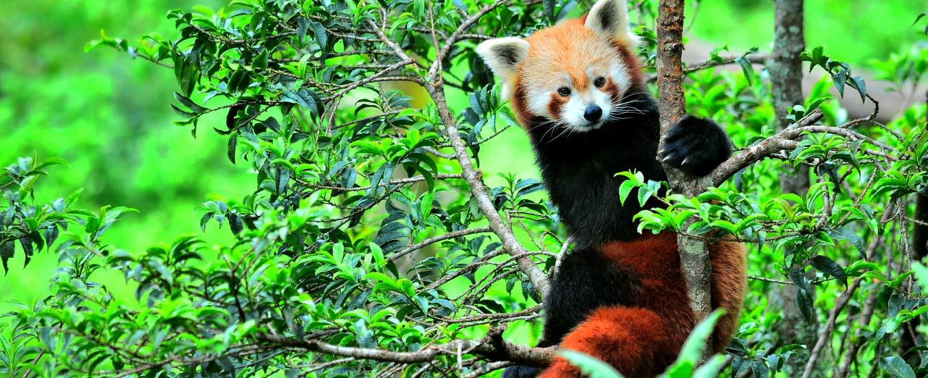
The sanctuary is filled with rhododendron, oak, chestnut and magnolia trees and is one of the richest butterfly spotting zones in Sikkim. One can also spot Red Pandas, Himalayan Black Bears and different varieties of deer at the sanctuary. It is best to visit the sanctuary between 8 am and 4 pm and remember that a permit needs to be acquired from the Home Department of the Government of Sikkim to visit the sanctuary. This can be easily obtained from tour operators. The first wildlife skywalk in India will be constructed at the Maenam Wildlife Sanctuary. The proposed construction of the 22 km rope-way from Maenam Wildlife Sanctuary to a skywalk will be built over the edge of the Bhalleydhunga steep face and there will be a rain shelter and public conveniences at the skywalk.
Geyzing
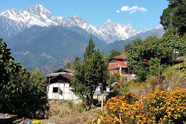
The capital city of the West Sikkim District, Geyzing, also known as Gyalshing is located at an altitude of 6,500 feet above sea level with mountains of the Himalayan range surrounding the city and the river Rangeet surging in the western part of the city. A few kilometres north is the town of Pelling. The town has a large Nepali population, and the Nepali language is the predominant language of the region. Near Geyzing is the ancient town of Yuksom, the ancient capital of Sikkim built in 1642. Other attractions include the Pemyangtse Monastery built in 1640, reputed to be Sikkim’s oldest and Khecheopalri Lake which as legend has it not a leaf is allowed to float on the surface. The town is the base for trekking in the Himalayas and professional expeditions to Mount Kanchenjunga. Yangtey, a hilltop that is a few km away from here, is located on the top of a cliff and offers a beautiful scenic view. Straight down is the river Rangeet and up ahead you can see the marvelous Kanchenjunga Mountains. Geyzing is also famous for the monasteries which are visited by several Buddhist pilgrims. Locally known as Sho Dzo Sho Lake, Khecheopalri Lake’s name comes from the surrounding Khecheopalri hill. The lake is considered to be holy by Hindu and Buddhist devotees and many legends revolve around the lake as it is believed that one’s wishes are fulfilled here. The Rabdentse Ruins is an archaeological site just a short walk from Pemayangtse Monastery. Established in the 17th century by Lama Lhatsun Chempo, the Sangachoeling Monastery is one of the oldest monasteries in Sikkim. Located at a distance of 7 km from Pemayangtse Monastery, it is perched on a ridge above Pelling. Built in the Tibetan style of architecture, the monastery is also known as the place of secret spells and was destroyed by fire several times since its inception. An unexplored and challenging trail, Dafeybhir Pass trek promises magnificent views of snow-clad mountains. It is the highest point in Singalila Trek and the path descends to the Gomathang valley.
Yangtey
At an altitude of 6000 ft, Yangtey is a small village lying very close to Pelling and famous for the amazing views of Mt. Kanchenjungha that it offers. It lies close to many tourist attractions like the Khangchendzonga waterfalls, Khecheopalri Lake, Rimbi Waterfalls, Rabdentse Ruins, Sewaro Rock Garden, Temi Tea Garden, Geyzing, Legship and the Pemyangtse Monastery. The time to see the snow-covered peaks during the winter season. The tiny hamlet also offers a spectacular sight of several mountain peaks like Rathong, Frey, Kabru Dom, Pandim, Narsing, Tinchikhang Siniolchu and Mt. Kanchenjungha.
Borong
A small beautiful village near Ravangla in South Sikkim, Borong is becoming increasingly popular because of village and eco-tourism activities. Located at an altitude of 5800 feet Borong has amazing views of the Kanchenjunga, Narsingh, Sinolchu, and Pandim peaks. One can also visit nearby places such as Fatak Village, Gerang Monastery, the Silver Falls, and the Barely Bridge. A hot fountain situated at a distance of 3km from Borong, on the bank of the Rangit River is a beautiful place to visit too. A festival takes place on the banks of the Rangeet River in February.
Mangan
Serving as the capital of northern Sikkim, Mangan is a major tourist location and the town is used as a base station from where they commence treks and tours to other parts of the state. Not only is Mangan the entry point to North Sikkim, but it is also developing into a tourist hotspot because of the breathtaking view of the Kanchenjunga range. A three-day music festival is organised here in December every year where bands from the region, as well as from the other Northeast states, perform for a huge crowd. Other attractions of Mangan include an exhibition cum sale of local handicrafts, a presentation of traditional cultural songs and dances and a food festival. The climate in Mangan is temperate as it lies at a lower altitude compared to other places in Sikkim. Winters and especially early winters are a good time to visit this place. Singhik, located 1560 m above sea level and about 4 km from Mangan, is a tiny settlement on a hill that offers a breathtaking view of Mt Kanchenjunga and Siniolchu. With ice-capped mountains watchable from a close range, this settlement is surrounded by lush green hills with river ridges along with the converging point of River Teesta and River Kanaka at the foothills. The Labrang Monastery is a museum that holds within it, statues, murals, language books and music. The walls of the museum are painted white, and the roofs of the museum are gilded in a mix of Tibetan and Indian styles of architecture. Currently, it contains 6 institutes of learning, a gilded stupa, 18 halls, a sutra debate area that houses 60,000 sutras. Built in 1983, Sirijonga Yuma Mangheem is a clone representative of the ancient Sirijunga Yuma Margheem of Maryam in West Bengal. Located amidst nature, the building is situated in such a way that it offers a beautiful view of the mighty mountains that are obstructed by white clouds, lush greenery and rivers flowing in full strength. Located in Nam Prik Dang, Rong Lungten Lee is a replication of a Lepcha Traditional House that has been converted into a museum. Located at the confluence of the Rivers Teesta and Kanaka, Rong Lungten Lee is famous because it is located in a calm environment with varieties of flora and fauna and the annual Sikkim festival, Namsoong. There are three rooms in Rong Lungten Lee, and each room displays various artefacts of different tribes of Sikkim heritage that are a souvenir of the past.
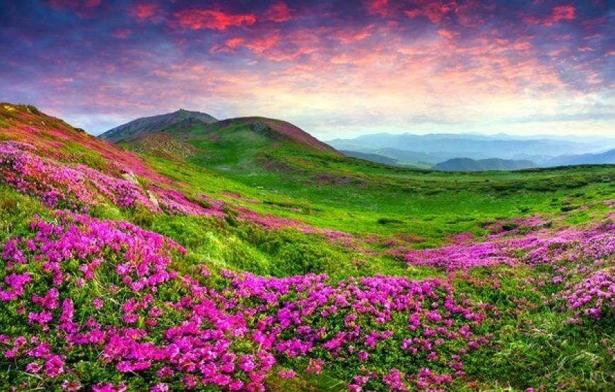
Chopta Valley
Famous as the Valley of Flowers, the Chopta Valley is popular for its riot of colours during the summer months. Lying at an altitude of 4023 m on the way to the Gurudongmar Lake, the valley maintains itself as a pristine and tranquil destination. The valley has majestic views of the snowy peaks, its slopes are covered in pine forests with grazing fields around the river meandering throughout the valley. All this makes it an ideal place for trekkers and explorers. Visitors often plan a combined visit to Chopta Valley with the Gurudongmar Lake, a sacred lake just a few km away. The Tso Lhamu Lake, about 9 km from Gurudongmar, is famous for being the source of the Teesta River. An hour’s drive from Lachen can reach the scenically blessed Thangu Village, where one can see the nomadic life of native tribes. Thangu Valley is just a short walk away, famous for its Yak race. The summer season which extends from March till May offers best climate to visit Chopta Valley while during winters, the valley is mostly frozen.

Lachung
Described as the most picturesque village in Sikkim by British explorer Joseph Dalton Hooker, Lachung is located at the confluence of the Lachen and Lachung Rivers, both tributaries of the River Teesta near the border with Tibet at an elevation of about 9,600 feet. The word Lachung means a small pass and the town is approximately 125 km from the capital Gangtok. The town is also a preferred base to visit the Yumthang Valley. The Indian Army has a forward base in the town. Before the Chinese occupation of Tibet in 1950, Lachung was a trading post between Sikkim and Tibet, after which it was closed down. Most of Lachung’s inhabitants are of Lepcha and Tibetan descent. Languages spoken here are Nepali, Lepcha and Bhutia. During winter the town is usually covered in snow. Lachung is also the base camp for Rhododendron Valley Trek which starts from Yumthang Valley and ends at Lachen Valley.
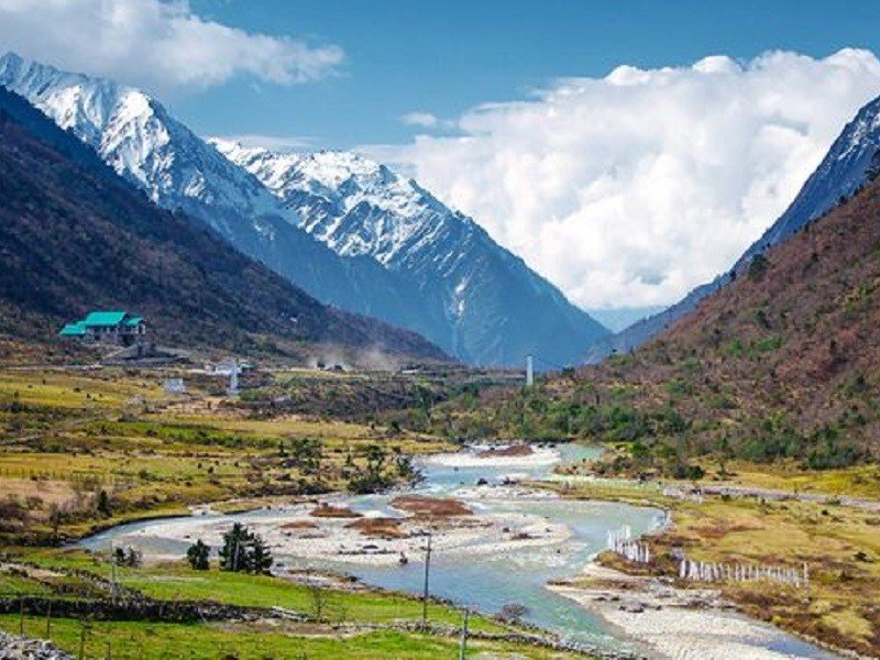
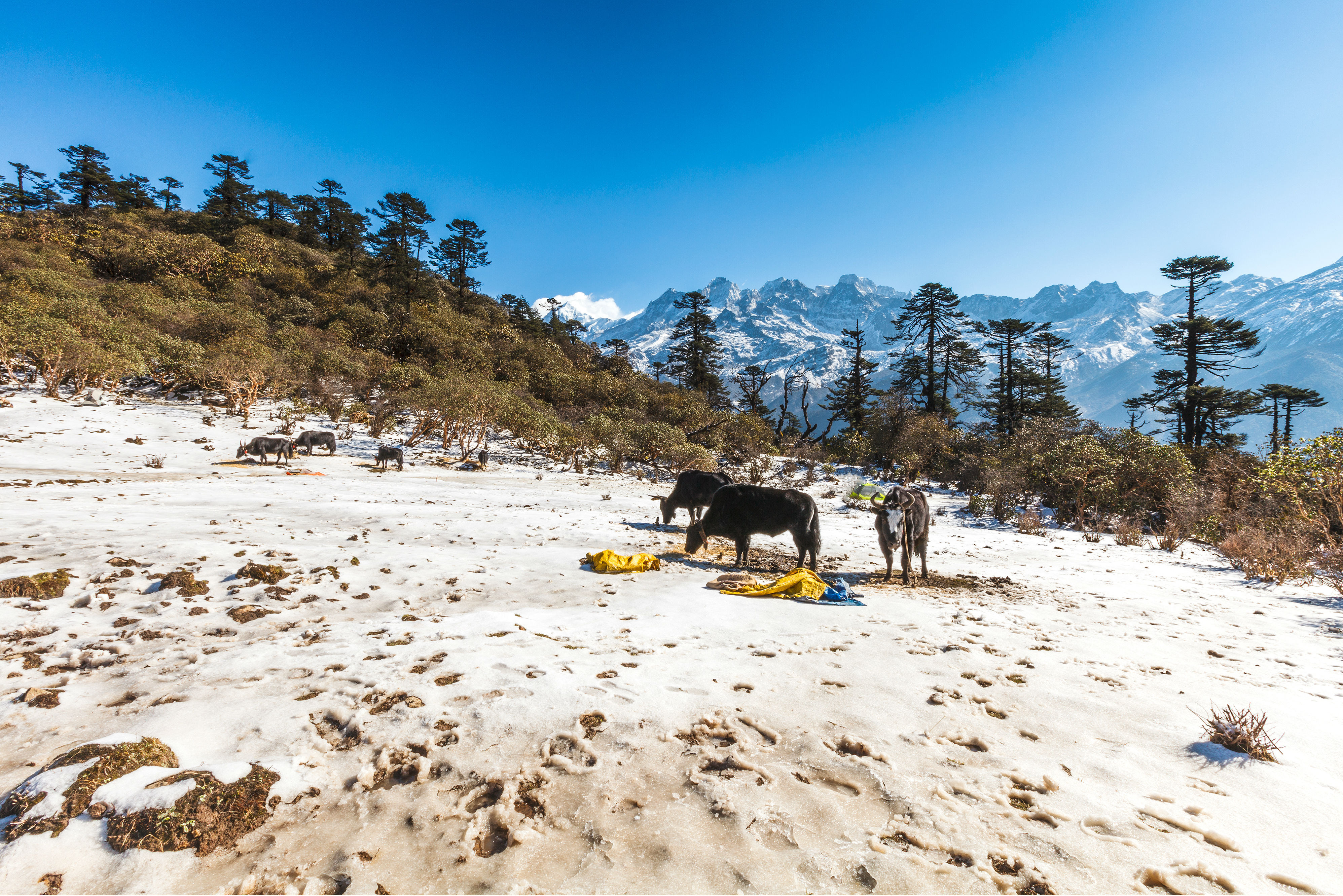
Alternatively known as Yumesamdong, Lachung Zero Point is located at an altitude of 15,300 feet above sea level and is the last outpost of civilization. The journey to Zero Point from Yumthang Valley is through tortuous and rugged roads and the snow-clad mountains, the flowing rivers, and the yaks grazing in search of vegetation make up for thrilling views. Roads end as Zero Point, after which there is only the vast desolate landscape. An Inner Line permit is required because of its proximity to the border, which can be obtained from the Tourist Information Centre or any registered tour operator. The best time to visit Zero Point is between February and June when the roads are clear and easily accessible. The Lachung Monastery was established in 1880 and a visit to the monastery is an interesting experience. Popularly known as the Sikkim Valley of Flowers, the Yumthang valley makes one feel like they have landed in the lap of nature. At an elevation of 3564 m, it has blooming flowers, flowing rivers, hot springs, and yaks grazing on meadows. The best season to visit Yumthang is from February to June when flowers cover the valley in hues of the rainbow. It is an hour’s drive from Lachung. Situated at the confluence of the Lachen and Lachung Rivers, Chungthang is a small picturesque town where one can halt while going to the Yumthang Valley. The river Teesta, also known as the lifeline of Sikkim originates here. The place has been associated with many legends and is considered a holy place blessed by Guru Padmasambhava, the patron saint of Sikkim. There is a stone that to this day bears the footprints of Padmasambhava. At an altitude of 13000 ft, the Thangu valley offers scenic views of countless alpine flowers and snowy landscapes and is ideal for nature lovers and trek enthusiasts as the valley provides a trekking base to the Chopta Valley and Muguthang. Besides the Teesta River, the Chopta, Thangu and Lassur Rivers also flow through this valley. Known as the tallest waterfall in Sikkim, the Bhim Nala Waterfall flows in three tiers and is located about 13 km from Lachung.
Lachen
Located in northern Sikkim at an elevation of 2,750 m, Lachen is well known for its Lachung monastery. Also famous as the gateway to the sacred Gurudongmar and Tso Lhamu lakes, the town’s name means a big pass. Lachen is also famous for the annual yak race, the Thangu which is held here in summer. Unlike other places in India, Lachen has its unique form of local self-governance called the Dzumsa. Every household is a member of this traditional administrative system, this institution is in charge of governing and organizing activities within the village. . The quaint Sikkim town is known for its lush vegetation that contains mainly grasslands and shrubs along with apple orchards. The pine-covered valleys and black cliffs of snowy-white hills of the Eastern Himalayas start from Lachen which makes it the base station for many trekking areas in the North Sikkim region including the famous Green Lake and Kanchenjunga National Park treks. Lachen provides expeditions to Chopta Valley, Green Lake, Cho-Lamu, Gurudongmar Lake, and Shinghba Rhododendron Sanctuary. The Gurdongmar Lake is a freshwater lake and one of the highest water bodies in the world as it is situated at an altitude of 5,210 m. The lake is positioned towards the North East of the Kanchenjunga range which freezes completely during winters. About 5 km ahead of this lake is the Tso Lhamo Lake. One needs prior permission from the army to trek from the Gurdongmar Lake to the Tso Lhamo Lake. The best time to visit Lachen is between May to September, as summers are moderate and quite enjoyable with mild to heavy rainfall during July and September.
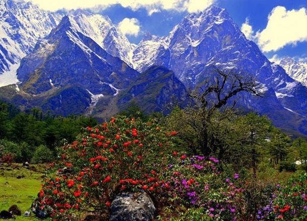
Yumthang Valley
Also known as the Sikkim Valley of Flowers sanctuary, the Yumthang Valley in North Sikkim is located 140 km north of Gangtok. This rare and exotic location with hot springs, rivers, yaks, and lush green meadows is situated at an elevation of 3564 m and houses the Shingba Rhododendron Sanctuary which has over 24 species of Rhododendron flowers, the Sikkim state flower blooming from late February to mid-June. The valley is closed to tourists between December and March due to heavy snowfall. A tributary of the river Teesta flows past the valley and the town of Lachung, the nearest inhabited town. A few hot springs are believed to have miraculous healing powers. On your way towards Yumthang Valley, one can see gushing waterfalls and streams along with a splendid view of peaks with the Pauhunri and Shundu Tsenpa. A forest rest house is the only permanent residence in the valley. As Yumthang Valley is situated close to the China border, the whole area is under army control. A Protected Area Permit is required to visit Yumthang which can be taken from Gangtok Tourism Office, the District Administrative Center at Mangan, or from the Chungthang Sub-Divisional Magistrate’s Office. Tour operators also arrange for the permit. The best time to take a trip to Yumthang valley commences from late February and lasts until June to experience the colourful flowers blossoming, which the valley is known for. However, if one wants to enjoy clear skies and a brilliant view of snow-capped mountains, then September to December would be ideal to visit. Another good time to visit Yumthang Valley is from February to March when the Losar festival is celebrated.

Thangu Valley
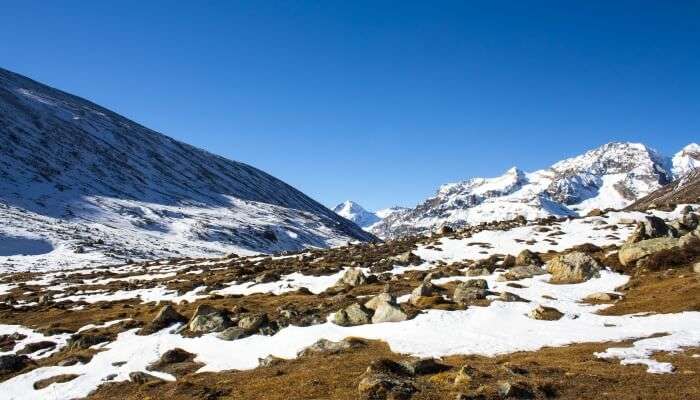
Located at an altitude of around 3900 m, Thangu is a beautiful village about two hours drive from Lachen where tourists usually choose to relax before they proceed to trek to Gurugongmar Lake, Muguthang or the Cho Lhamu Lake. In Thangu Valley, one can catch a glimpse of the rows of trees and as one goes more upwards, the beautiful view of the Tibetan Plateau begins. The ideal time to travel to Thangu Valley would be between May and June, during which, the entire valley gets decorated with vibrant alpine flowers, and the heavy snow covers up these beautiful beds of flowers in the cold months between October and March. The spectacular hiking trails from Thangu Chopta Valley and Muguthang enhance the beauty of the village. Since Thangu is near the border between India and China, there is also a big military base present here. During winter, Thangu can get quite cold. The Gurdongmar Lake nearby freezes completely during the winter months and looks beautiful.

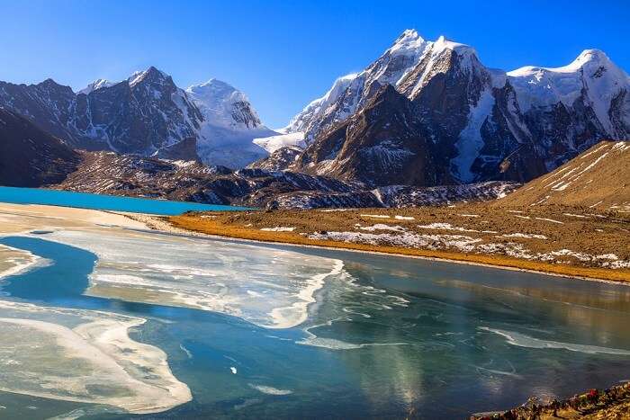
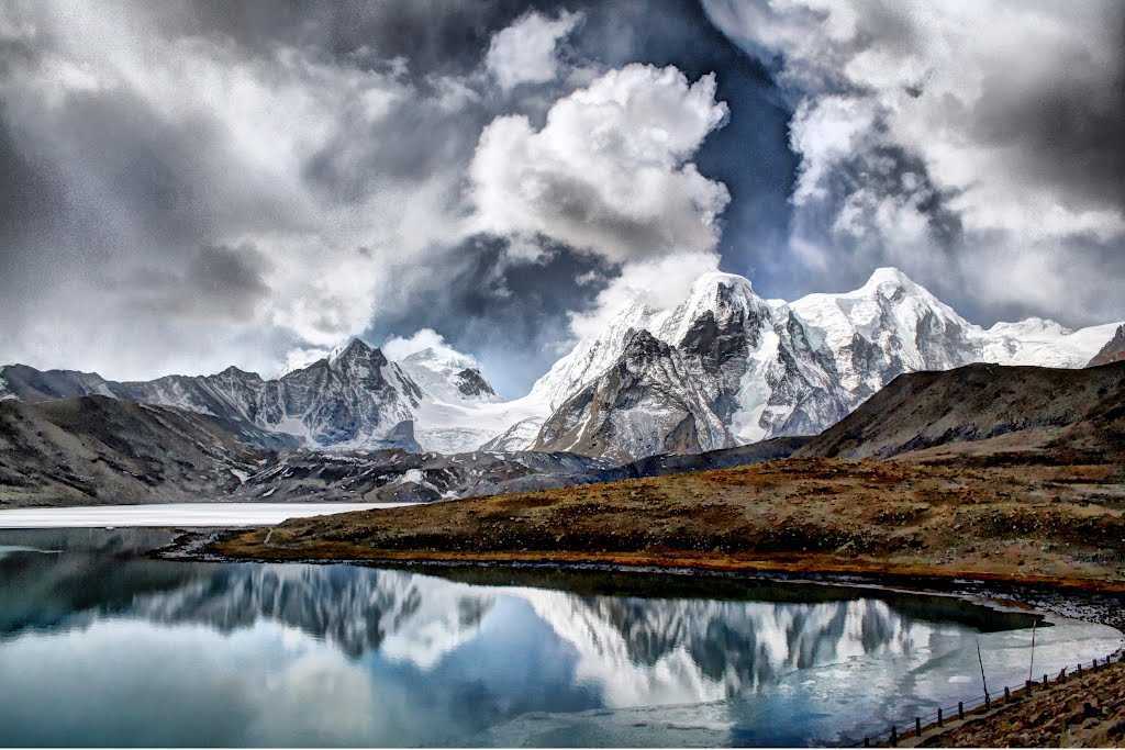
Gurudongmar Lake
One of the highest lakes in the world, at an elevation of 5,430 m, Gurudongmar Lake is located in the Great Himalayas and is considered sacred by Buddhists, Sikhs, and Hindus. The lake is named after Guru Nanak, known as Nanak Lama in Sikkim, who visited here during his third Udasi or travel around 1516.
Located 190 km from Gangtok and about 5 km south of the Tibetan border, the lake can be reached by road from Lachen via Thangu. While Indian tourists are allowed to visit the lake, foreigners need to get a special permit from the Ministry of Home Affairs in Delhi. The lake, fed by glaciers, is located to the north of the Kanchendzonga range, in a high plateau area connected to the Tibetan Plateau and provides one of the source streams which joins the Tso Lahmu and then form the source of the Teesta River. The lake remains completely frozen in the winter months, from November to Mid-May. The lake has an area of 290 acres and its peripheral length is 5.34 km, however the size of the lake appears small where devotees offer worship because the larger part of the lake is not visible due to the hilly topography obstructing the view. The area surrounding the lake, also known as Gurudongmar, is inhabited by Yaks, blue sheep, and other wildlife. The lake is fresh water and used to be very clear; the bed of the lake could even be seen from the middle of the lake. Pollution has muddied the waters in recent years, and the lake has taken on a white tinge and has obscured visibility. The water of Gurudongmar Lake is believed to have healing powers, and many tourists carry the water with them on their way back. Gurudongmar Lake is named after Guru Padmasambhava, who was also known as Guru Rinpoche, the founder of Tibetan Buddhism who visited the lake in the 8th century. The lake, however, remained frozen throughout large parts of the year, and thus there was no way that it could meet the drinking water needs of the people. The locals then appealed to the guru, who decided to help them. He placed his hand on the part of the lake, and the ice in that particular spot began to melt. A legend related to the frozen condition of the lake is linked to the visit of Guru Nanak to the lake during his visit from Chungthang to Bhutan, on his way back from Tibet. Because the lake remained frozen most of the year with no possibility of providing for drinking water needs, the yak grazers approached Guru Nanak with a request to help them. The guru hit the perpetually snow-covered Guru Dongmar Lake with his stick to provide water to the grazers. The ice melted giving way to crystal clear water. Since then, the water of the lake is stated to never freeze. The lake and the hill feature atop came to be known as Gurudongmar Lake and hill respectively. The same names are found recorded in the ancient maps prepared by the British in the nineteenth century. The best time to visit Gurudongmar Lake is between November and June as the weather is quite pleasant at that time of the year. The lake freezes completely during the winter months and is a treat to the eyes.
Cholamu Lake
Also known as the Tso Lhamo Lake, Cholamu Lake is one of the highest lakes in the world, located at an altitude of 16,700 ft. It is located in North Sikkim, about 4 km southwest of the international border with China, and is a freshwater lake fed by waters from the Zemu Glacier, the Kangtse Glacier, or the Pauhunri Glacier, and is the source of the Teesta River. Because of its location, it is off limits to most visitors and one needs special permits, from the Army and the Sikkim Policea and administration to visit the lake. The ideal time to visit Cholamu Lake are the months of October and November as one can witness a clear sky during this time of the year.
Shingba Rhododendron Sanctuary
Nestled in the Yumthang Valley of Flowers in North Sikkim, the Shingba Rhododendron Sanctuary is known for the exquisite rhododendrons found here. Part of the Sacred Himalayan landscape, the sanctuary sprawls over an area of 43 sq km and comprises over forty species of rhododendrons, at an elevation of 3,048 to 4,575 m. Azaleas bloom to their full capacity and turn the Shingba Rhododendron Sanctuary into a riot of colours from April to July thereby making it the best time to visit. Bird species found in the park include Wood snipe and Hoary-throated barwing. The sanctuary gets its picturesque look from the Yumthang Chhu meandering through it. Since Shingba Rhododendron Sanctuary is situated close to the Tibetan Plateau, it also experiences long winter seasons. The perfect time to visit the sanctuary is during April and May since one gets to enjoy the beauty of the blooming flowers.

Khangchendzonga National Park
Named after the third highest mountain peak in the world, and nestled in the lap of the Himalayas in northern Sikkim is the Kanchenjunga National Park. Included recently in UNESCO’s world heritage sites, it is a rare high altitude national park and the first Mixed-Heritage site in the country. Also spelt as Khangchendzonga National Park, the national park is located at an elevation of 8586 meters, and lies partly in Nepal and partly in Sikkim. The park is home to most endemic and rare species of flora and fauna including the Snow Leopard and Himalayan Tahr and adjoins the Qomolangma National Nature Preserve in Tibet and the Kanchenjunga Conservation Area in Nepal. A new species of bird named Himalayan Forst Thrush was discovered in 2016. There are numerous glaciers inside the national park with the Zemu glacier being the most significant one with a length of twenty-six km. There are a few Lepcha tribal settlements inside the park and it also contains the Tholung Monastery, a gompa located in the park’s buffer zone, considered one of the most sacred monasteries in Sikkim.
The Kanchenjunga National Park gets its name from the third highest mountain in the world – the Kanchenjunga which means the abode of God. The national park is juxtaposed against this mountain, which acts as a striking background at an imposing height of 8586 meters. This area was declared a National Park in 1977. Initially, the area of the National Park was 850 km sq which was extended to 1784 km sq. In Buddhism, Sikkim is presented as sacred land and according to some scriptures, the area of the park is originally the sanctum sanctorum where the Buddhist masters had hidden the religious treaties and texts to be later discovered by the people. According to the officials, these hidden treasures are called ters, destined to be discovered by ter-tons who are treasure revealers.
Entry to the Khangchendzonga National Park is restricted and regulated. An inner-line permit needs to be obtained by the Indian Nationals and a restricted area permit by the foreign Nationals, issued by the Ministry of Home Affairs. A permit also needs to be taken from the Chief Wildlife Warden, Government of Sikkim following the Wildlife (Protection) Act, 1972. For Indians, the permit costs INR 300 per head for the first seven days with INR 40 for each additional day. For foreign nationals, it is INR 560 per head for the first seven days and INR 80 for each additional day. Students pay INR 80 per head for the first seven days and INR 20 for each additional day. Tent charges are INR 50 per day while guide charges are INR 10 per day. For photography, a camera fee of INR 30, a video camera fee of INR 100 and a movie camera fee of INR 35,000 will be imposed.
There are several popular trekking options at the park and permits for all treks are obtained from the Wildlife Education and Interpretation Center at Yuksum which is the starting point of most of these treks. The best to visit the national park is from March to May and September to mid-December. It receives snowfall most of the year.

Fambong Lho Wildlife Sanctuary
The Fambong Lho Wildlife Sanctuary is a 51 sq km large wildlife sanctuary in east Sikkim, contiguous with the Khangchendzonga National Park and located around 30 km west of Gangtok. It hosts a few small hamlets inside, namely Dikchu, Pangthang, and Mangan, and is managed by State Forest Department. The sanctuary lies between 1524 m and 2749 m and at the top of Fambong Lho is the Chuli hamlet. The is no human habitatation is there between the log house of Fambong Lho and Chuli trekkers hut. The highest point of this wildlife sanctuary is Tinjure.

Goecha La
Goecha La is a high mountain pass located at a height of 4,940 m and acts as the base camp for the southeast face of Kanchenjunga. This place can only be accessed by trekking from Yuksom and it roughly takes 7-8 days for a person to reach Goecha La and come back to Yuksom. The area is accessible only after proper permits are granted.
And this ends our series on Sikkim, a state that begs you to visit because of the immense beauty it holds. I’ll be back soon to explore yet another Indian state, so keep a lookout.
