
With a name that means the abode of clouds, Meghalaya is a state in northeastern India that was formed by carving out two districts from the state of Assam – the United Khasi Hills and Jaintia Hills, and the Garo Hills on 21 January 1972. The state is bound to the south and west by Bangladesh and the north and east by Assam. Nicknamed the Scotland of the East by the British colonial rule, Meghalaya is the wettest region of India, with the wettest areas in the southern Khasi Hills recording an average of 12,000 mm or 470 in of rain a year. The state capital is Shillong and English is the state’s official language.
Meghalaya, alongside its neighbouring states, has been of archaeological interest. People have lived in Meghalaya since the Neolithic period and Neolithic sites discovered so far are located in the areas of high elevation in the Khasi Hills, Garo Hills and in states, where the Neolithic style of jhum or shifting cultivation is practised even today. The importance of Meghalaya is its possible role in the domestication of rice. After the Conquest of Taraf in 1304, Shah Arifin Rafiuddin, a disciple of Shah Jalal, migrated and settled in the Khasi and Jaintia Hills where he preached Islam to the local people. His khanqah or the building used for gatherings remains in Sarping/Laurergarh on the Bangladeshi border but the part containing his tomb is in Meghalaya on top of Laur Hill.

The Khasi, Garo, and Jaintia tribes had their kingdoms until they came under British administration in the 19th century. Later, the British incorporated Meghalaya into Assam in 1835. The region enjoyed a semi-independent status under a treaty relationship with the British Crown. When Bengal was partitioned on 16 October 1905 by Lord Curzon, Meghalaya became a part of the new province of Eastern Bengal and Assam. However, when the partition was reversed in 1912, Meghalaya became a part of the province of Assam. On 3 January 1921, the governor-general-in-council declared the areas now in Meghalaya, other than the Khasi states, as backward tracts.
At the time of Indian independence in 1947, present-day Meghalaya constituted two districts of Assam and enjoyed limited autonomy within the state of Assam. A movement for a separate Hill State began in 1960 and on 11 September 1968, the Indian Government announced a scheme for constituting an autonomous state within the state of Assam comprising certain areas. Accordingly, the Assam Reorganisation (Meghalaya) Act of 1969 was enacted for the formation of an autonomous state and Meghalaya was formed by carving out two districts from the state of Assam, the United Khasi Hills and Jaintia Hills, and the Garo Hills. The name Meghalaya coined by geographer S.P. Chatterjee in 1936 was proposed and accepted for the new state and the state came into being on 21 January 1972, with a Legislative Assembly of its own.[8]
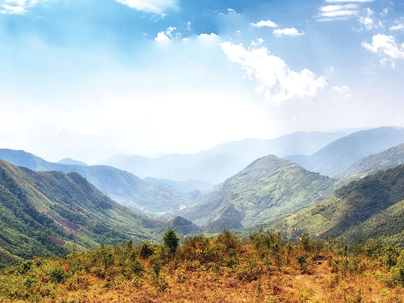
Meghalaya is a mountainous state with stretches of valley and highland plateaus, and it is geologically rich. It consists mainly of Archean rock formations. These rock formations contain rich deposits of valuable minerals like coal, limestone, uranium and sillimanite. About 70% of the state is forested and is known for its biodiversity. The mountain forests are distinct from the lowland tropical forests to the north and south. These forests receive abundant rainfall and support a vast variety of floral and faunal biodiversity. A small portion of the forest area in Meghalaya is under what is known as sacred groves. These are small pockets of an ancient forest that have been preserved by the communities for hundreds of years due to religious and cultural beliefs. These sacred groves harbour many rare plant and animal species. The Nokrek Biosphere Reserve in the West Garo Hills and the Balphakram National Park in the South Garo Hills are considered to be the most biodiversity-rich sites in Meghalaya.
Meghalaya has predominantly an agrarian economy with a significant commercial forestry industry. The state is geologically rich in minerals, but it has no significant industries and is a major logistical centre for trade with Bangladesh. With the average annual rainfall as high as 12,000 mm in some areas, Meghalaya is the wettest place on Earth. The town of Sohra in Cherrapunji in the Khasi Hills south of the capital of Shillong holds the world record for most rain in a calendar month, while the village of Mawsynram, near Sohra in Cherrapunji, holds the record for the most rain in a year.
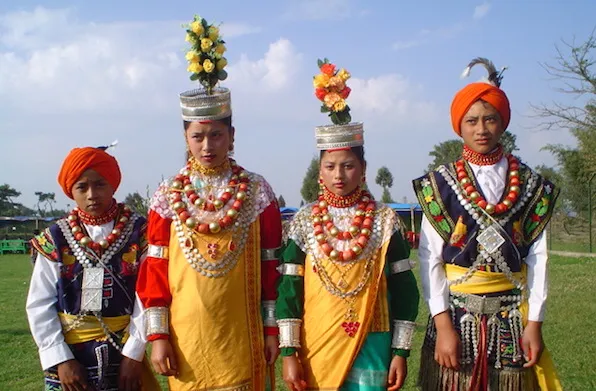
Meghalaya has one of the world’s largest surviving matrilineal cultures. Unlike many Indian states, Meghalaya has historically followed a matrilineal system where the lineage and inheritance are traced through women; the youngest daughter inherits all wealth and she also takes care of her parents. In some cases, such as when there is no daughter in the family or for other reasons, the parents may nominate another girl such as a daughter-in-law as the heir of the house and all other property they may own. Tribal people make up the majority of Meghalaya’s population. The Khasis are the largest group, followed by the Garos then the Jaintias.
Meghalaya is famous for its living root bridges, a kind of suspension bridge made over rivers using intertwined roots of Ficus elastica trees planted on opposite banks of the river or hill slopes and slowly training the aerial roots. These living bridges are made by both the Khasis and the Jaintias. Large numbers of these man-made living structures exist in the mountainous terrain along the southern border of the Shillong Plateau, though as a cultural practice they are fading, with many individual examples having disappeared recently, either falling in landslides or floods or being replaced with more standard steel bridges. Meghalaya has an estimated 500 natural limestone and sandstone caves spread over the entire state including most of the longest and deepest caves in the sub-continent.
Previously, foreign tourists required special permits to enter the areas that now constitute Meghalaya, but these restrictions were removed in 1955. Major issues in the state include illegal migrants from Bangladesh, incidences of violence, political instability and deforestation from traditional cut-and-burn shift farming practices. There are also several clashes between Khasi people and Bangladeshi Muslims in Meghalaya.
In the next part, we will explore more of the state’s capital and its largest city, Shillong.
