
India’s third-smallest state, Tripura lies in northeast India and is bordered by Bangladesh to the north, south, and west, and Assam and Mizoram to the east. Tripura is located in an isolated hilly region of the country, with various indigenous peoples, or tribes, accounting for a significant portion of the population. The area of modern Tripura which was ruled for several centuries by the Manikya Dynasty was part of an independent princely state under the protectorate of the British Empire. The independent Tripuri Kingdom, also known as Hill Tippera joined the newly independent India in 1949.
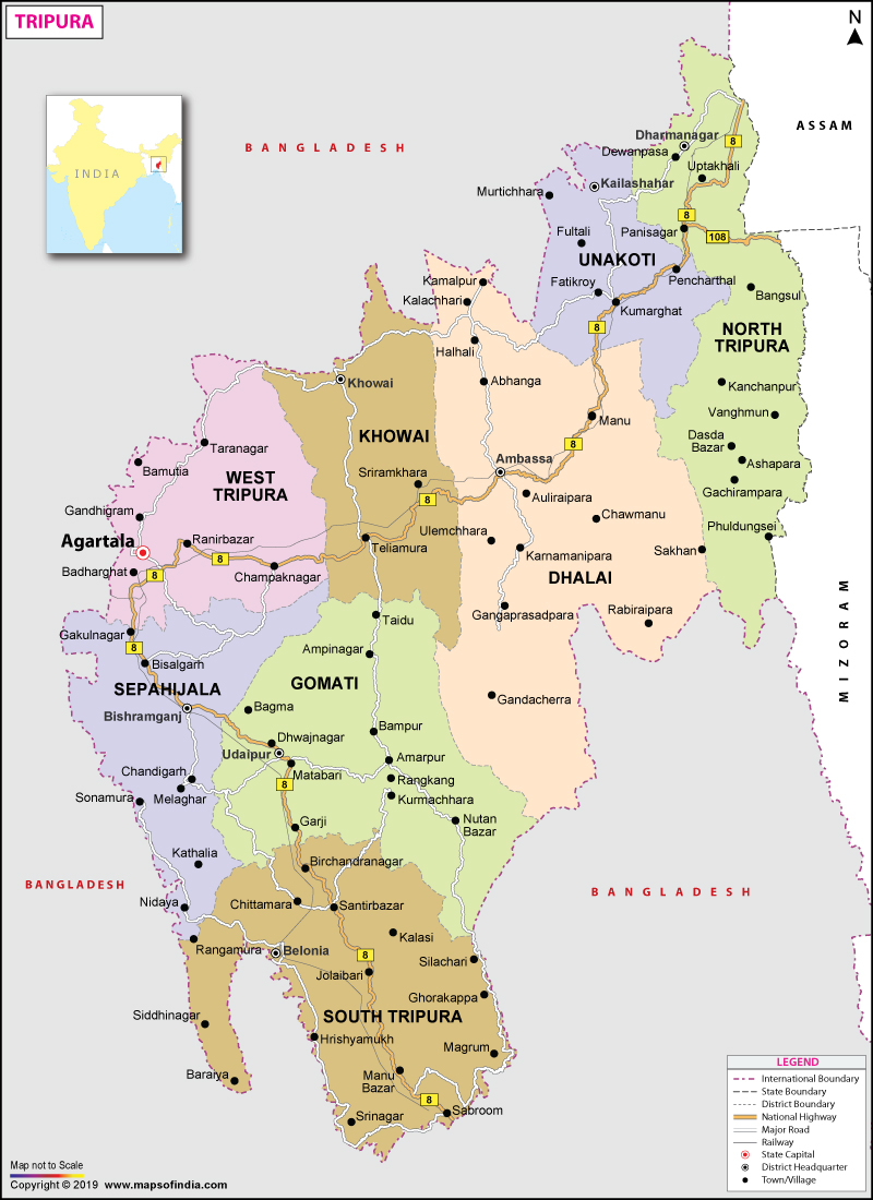
Tripura lies in a geographically isolated location in India, as only one major highway, the National Highway 8, connects it with the rest of the country. Five mountain ranges — Boromura, Atharamura, Longtharai, Shakhan and Jampui Hills — run north to south, with intervening valleys. Agartala, the capital, is located on a plain to the west. The state has a tropical savanna climate and receives seasonal heavy rains from the southwest monsoon.

Forests cover more than half of Tripura, in which bamboo and cane tracts are common. Tripura has the highest number of primate species found in any Indian state. Due to its geographical isolation, economic progress in the state is hindered with poverty and unemployment continuing to plague the state, which has a limited infrastructure. Most residents are involved in agriculture and allied activities, although the service sector is the largest contributor to the state’s gross domestic product. According to the 2011 census, Tripura is one of the most literate states in India, with a literacy rate of 87.75%.
The origin of Tripura’s name is still a matter of controversy among historians and researchers. According to the Rajmala, Tripura’s celebrated court chronicle, an ancient king named Tripur ruled over the territorial domain known as Tripura and the name of the kingdom was derived from his name. Many researchers explain the name Tripura from its etymological origin: the word is a compound of two separate words, tui which means water and pra which means near which in totality means near water. The geographical location of the state with its proximity to the vast water resources of eastern Bengal coupled with the generic identity of the state’s original inhabitants as Tipra or Twipra justify this explanation of the state’s name.

The early history of the kingdom of Tripura is a complex blend of history and mythology. According to the Rajmala, Tripura’s royal house trace their origin to the lunar dynasty, following in the footsteps of their counterparts in the Hindu royal houses of the rest of India who claim to have originated from the lunar or solar dynasties. The name Tripura is linked to the Hindu goddess Tripura Sundari, the presiding deity of the Tripura Sundari Temple at Udaipur, one of the 51 shakti peethas and to the legendary tyrant king Tripur, who reigned in the region. Tripur was the 39th descendant of Druhyu, who belonged to the lineage of Yayati, a king of the Lunar Dynasty.
The Indian epic, the Mahabharata; ancient religious texts, the Puranas; and the Edicts of Ashoka which are stone pillar inscriptions of the emperor Ashoka dating from the third century BCE, all mention Tripura. The Rajmala, a chronicle of Tripuri kings which was first written in the 15th century, provides a list of 179 kings, from antiquity up to Krishna Kishore Manikya who ruled between 1830 and 1850.
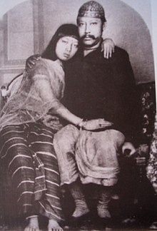
Tripura became a princely state during British rule in India. The Tripura kings had an estate in British India, known as the Tippera district or Chakla Roshnabad, now the Comilla district of Bangladesh, in addition to the independent area known as Hill Tippera, roughly corresponding to the present-day Tripura state. Udaipur, in south Tripura, was the capital of the kingdom, until King Krishna Manikya moved the capital to Old Agartala in the 18th century. It was moved to the new city of Agartala in the 19th century. Bir Chandra Manikya who ruled between 1862 and 1896 modelled his administration on the pattern of British India, and enacted reforms including the formation of the Agartala Municipal Corporation. Following India’s independence in 1947, Tippera district, the estate in the plains of British India, became the Comilla district of East Pakistan, and Hill Tippera remained under a regency council until 1949. The Maharani Regent of Tripura signed the Tripura Merger Agreement on 9 September 1949, making Tripura a Part C state of India. It became a Union Territory, without a legislature, in November 1956 and an elected ministry was installed in July 1963. It was conferred full statehood in 1971 by the North-Eastern Areas (Reorganisation) Act, 1971. The geographic partition that coincided with the independence of India resulted in major economic and infrastructural setbacks for the state, as road transport between the state and the major cities of the newly-independent India had to follow a more circuitous route, around East Pakistan. The road distance between Kolkata and Agartala before the partition was less than 350 km or 220 miles, and increased to 1,700 km or 1,100 miles, as the route now avoided East Pakistan. The geopolitical isolation was aggravated by an absence of rail transport.
After the partition, many Bengali Hindus migrated to Tripura as refugees fleeing religious persecution in Muslim-majority East Pakistan, especially after 1949. Parts of the state were shelled by the Pakistan Army during the Indo-Pakistani War of 1971. Following the war, the Indian government reorganised the North East region to ensure effective control of the international borders with three new states coming into existence on 21 January 1972 – Meghalaya, Manipur, and Tripura. Pre-independence, most of Tripura’s population was indigenous, but the migrations by Bengali Hindus led to scattered violence, and an insurgency spanning decades, including occasional massacres such as the 1980 Mandai massacre. This gradually abated following the establishment of a tribal autonomous district council and the use of strategic counter-insurgency operations.

Tripura is characterised by hill ranges, valleys and plains. The state has five anticlinal ranges of hills running north to south, from Boromura in the west, through Atharamura, Longtharai and Shakhan, to the Jampui Hills in the east. At an altitude of 939 m, Betling Shib in the Jampui range is the state’s highest point. The small isolated hillocks interspersed throughout the state are known as tillas, and the narrow fertile alluvial valleys, mostly present in the west, are called Doóng or lungas. Several rivers originate in the hills of Tripura and flow into Bangladesh with the Khowai, Dhalai, Manu, Juri and Longai flowing towards the north; the Gumti to the west; and the Muhuri and Feni to the south-west. Tripura is predominantly rural with the highest densities of the rural population found in the state’s most fertile agricultural lands, located in the western plain and the Gumti, Dharmanagar, and Khowai valleys. Rice is the major crop in Tripura and accounts for 91 percent of the land under cultivation. Towns are concentrated on the western plain and the state capital of Agartala is the largest city. Most of the population, adhering to Hinduism and speaking Bengali, shares the broader cultural traditions of India, while the Muslim minority is closer in culture to Bangladesh. The traditions of the tribal peoples also are important elements of Tripura’s cultural life, with each community possessing its festivals, folklore, music, and dance. Pisciculture has made significant advances in the state and Rubber and tea are important cash crops. Tripura ranks second to Kerala in the production of natural rubber in the country. The state is known for its handicraft, particularly hand-woven cotton fabric, wood carvings, and bamboo products.
The Tripura Hills, by way of the Mizo Hills of Mizoram state on the east, form a low western extension of the Purvachal, a strategically located highland region fronting the border with Myanmar. The region belongs to the Assam-Burma geologic province, an unstable seismic zone crisscrossed by several faults and extending into Myanmar. The hills are a series of parallel north-south folds, decreasing in elevation to the south until they merge into the greater Ganges-Brahmaputra lowlands, also called the Eastern Plains. Each successive ridge of hills to the east rises higher than the one before; the low Deotamura Range is followed by the Artharamura, Langtarai, and Sakhan Tlang ranges. The Jamrai Tlang Mountains, 46 miles (74 km) in length, have the highest peak, Betling Sib (3,280 feet [1,000 metres]).

Two of Tripura’s largest festivals are the Kharchi Puja and the Garia. The Kharchi Puja, also known as the Festival of the 14 Gods, has its origins in tribal tradition but is now a major temple festival celebrated within a predominantly Hindu framework by both tribal and nontribal peoples. It takes place in Agartala every July and honours the deities and the Earth. The Garia celebration is a prominent festival of the indigenous population and is associated particularly with the Tripuri people. Garia is held each April following the planting of the fields to pray for a successful agricultural year.
