Festivals of India: Hariyali Teej

Also known as Chhoti Teej, Madhusrava Teej and Shravana Teej, today is the festival of Hariyali Teej aka Green Teej, a festival celebrated on the third day after the full moon in the month of Shraavan, the fifth month of the Hindu calendar which begins in mid to late July and ends in August. As this is the monsoon season when the surroundings become green, the Shraavana Teej is also called Hariyali Teej. The month of Shravan is very important for the sub-continent as it is connected to the arrival of the south-west monsoons. The festival usually falls a couple of days before the festival of Nag Panchami, when snakes are worshipped. The festival of Hariyali Teej holds the same significance as Karwa Chauth observed by the married Hindu women in certain parts of India.

Teej is the generic name for a number of Hindu festivals that are celebrated by women in many parts of India, mainly in north and central India and Nepal. The monsoon festivals of Teej are primarily dedicated to Goddess Parvati and her union with Lord Shiva with women often fasting in celebrations. Teej refers to the third day that falls every month after the new moon or amavasya, and the third day after the full moon night of every month. The festival celebrates the bounty of nature, the arrival of clouds and rain, greenery and birds with social activity, rituals and customs. These festivals for women, include dancing, singing, getting together with friends and telling stories, dressing up with henna-coloured hands and feet, wearing red, green or orange clothes, sharing festive foodsand playing under trees on swings.

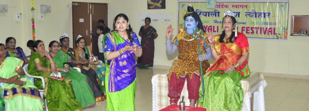
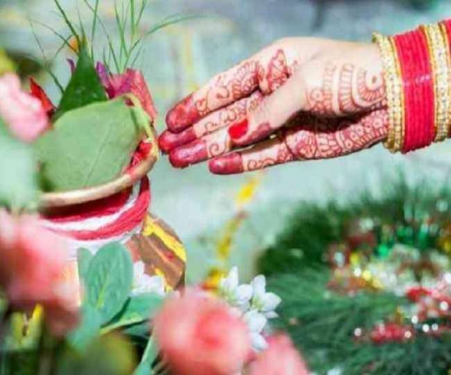
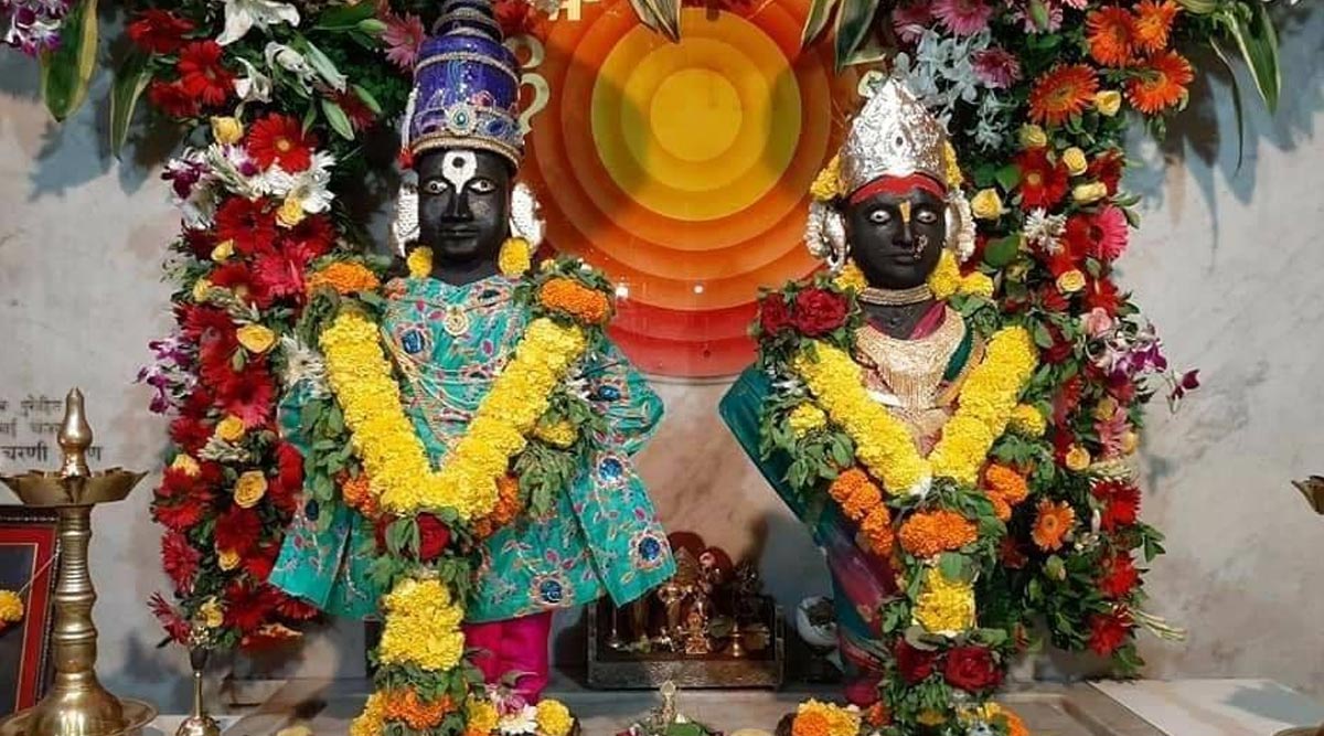
Hariyali Teej is also celebrated to remember the reunion of Lord Shiva and Goddess Parvati, the day they married. As per Hindu mythology, on this day, an incarnation of Goddess Parvati was abducted by her friends to stop her marriage with Lord Vishnu. Goddess Parvati’s friends knew that she secretly loved Lord Shiva and yearned to marry him, so her friends kidnapped and hid her in the forest. Goddess Parvati used this time to pray Lord Shiva who was so moved by the prayers that he agreed and they were married with the blessings of her father. Goddess Parvati fasted and was austere for many years and was accepted by Lord Shiva as his wife in her 108th birth and is also known as Teej Mata. Devotes observe fast and do a special puja (prayer) to worship the moon with milk, flowers, and curd. On Sindhara Teej married daughters receive the gifts by her mother such clothes, bangles, bindi, mehandi, etc. Ghevar, a special sweet, are given to them on this day. These gifts are known as Sindhara.

On Teej, just as on Karva Chauth, the mother sends a baya or gift. The baya, which consists of a variety of foodstuffs, is placed on a thaali or a plate at a place of worship where a chowk or square has been decorated, and an idol or picture of Goddess Parvati has been installed. The puja is performed in the morning while the evenings are set aside for folk singing and dancing, including women’s prayers for their husbands’ longevity and their families.

The traditional areas of celebration of Hariyali Teej are Punjab, Haryan Uttar Pradesh, Bihar, Jharkhand, Madhya Pradesh and Rajasthan.

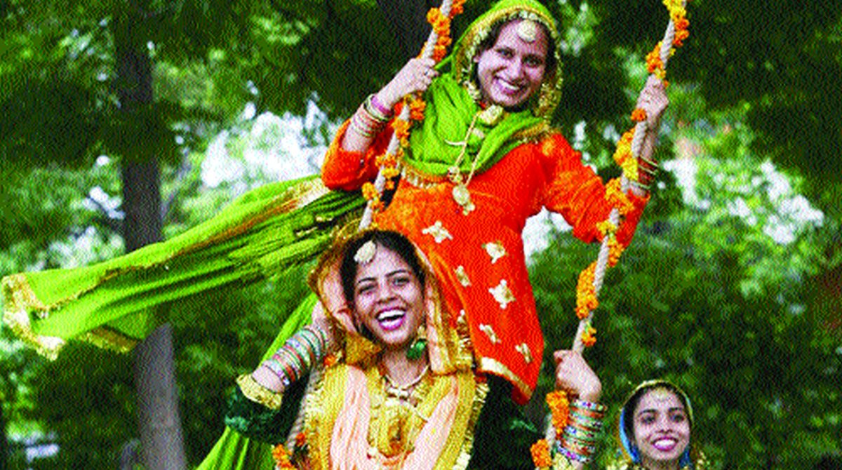
In Punjab, Teej is known as Teeyan and is seen as a seasonal festival which is dedicated to the onset of the monsoon. During Hariyali Teej, girls play on swings that are set up under trees or open courtyards and during Teej, in-laws, husbands and other family members give gifts, typically new clothes and accessories, to girls and women. Boys fly kites and make sweets. The festival is celebrated by women of all faiths, and lasts from the third day of the bright half of the lunar month of Sawan as per the Punjabi calendar to the full moon of Sawan for about 13 days. Teeyan involves women getting together and performing Gidda, married women visiting their families and receiving gifts. It is also traditional for women to ride on swings. Fairs are organised in schools and colleges where dance competitions are held.

In Haryana, the festival is celebrated as an official holiday. Many functions are organised by the government to celebrate this festival, which welcomes the rainy season. Boys traditionally flew kites from morning to evening. Swings are set up in open courtyards, under trees for the season. Girls apply henna to their hands and feet and are excused from household chores on this day. On Teej, girls often receive new clothes from their parents.

In Rajasthan, Teej welcomes the monsoon and is observed in the month of Shravan which comes in July or August. The monsoon rains fall on the parched land and the pleasing scent of the wet soil rises into the air. Swings are hung from trees and women dressed in green clothes sing songs in celebration of the advent of the monsoon. This festival is dedicated to Goddess Parvati, commemorating her union with Lord Shiva. Goddess Parvati is worshipped by seekers of conjugal bliss and happiness. An elaborate procession is taken out in Jaipur for two consecutive days during the festival watched by people in large numbers. The Teej idol is covered with a canopy whereas the Gangaur idol is open. The traditional ghevar sweet is also associated with the festival. The day before Haryali Teej, is celebrated as Sinjara, wherein women put henna on their hands and eat.

The celebrations of Hariyali Teej are very elaborate in all the Krishna temples in Vridavan in Uttar Pradesh. Swings are laid for the deity and this ceremony is known as Jhullan Leela. Religious hymes and songs are chanted in all the temples and idols of Lord Krishna and Goddess Radha are beautifully adorned with ornaments and after the celebrations; water is showered over the devotees to mark the arrival of monsoons.

The tradition of Vat Vriksha also forms an important part of the Shravani Teej. In many places, swings are hung on the branches of a banyan tree or Vat Vriksha and even in houses. Women spend the day swinging along and dancing and singing with other women. On the day of Hariyali Teej women are given all the liberty for enjoyment and merry making. In Hindu mythology the banyan tree is sacred and its hanging branches are said to reflect knowledge. So, worshipping the Vat Vriksha on the occasion of Hariyali Teej is also considered auspicious.

On the day of Hariyali Teej, women also observe strict fast known as Nirjala Vrat, where they are not allowed to even drink water for the whole day. The Hariyali Teej vrat can be kept both by married and unmarried women and the fast is broken at night after worshipping the moon. On this day women worship Teej Mata or Goddess Parvati for the prosperity and well-being of their husbands. The idols of Lord Shiva and Goddess Parvati are worshipped and songs are sung in their honour.

Festivals of India: Ashadi Ekadashi

Tomorrow is Ashadi Ekadashi which is also known variously as Shayani Ekadashi which literally means sleeping eleventh or the Maha Ekadashi or the great eleventh or Prathama Ekadashi or the first eleventh. It is the eleventh lunar day or ekadashi of the bright fortnight or shukla paksha of the Hindu month of Ashadha which happens sometime in June or July and so is also known as Ashadhi Ekadashi or Ashadhi. This holy day is of special significance to Vaishnavas, followers of the Hindu protector God, Lord Vishnu.

On this day images of Vishnu and Lakshmi are worshipped and the entire night is spent chanting prayers and devotees keep fast and take vows on this day, to be observed during the entire chaturmas, the holy four-month period of rainy season. These may include, giving up a food item or fasting on every Ekadashi day. It is believed that Lord Vishnu falls asleep in Ksheersagar or the cosmic ocean of milk on Shesha naga, the cosmic serpent. Thus the day is also called Dev Shayani Ekadashi or the god sleeping eleventh or Hari Shayani Ekadashi or Vishnu sleeping eleventh. Vishnu finally awakens from his slumber four months later on Prabodhini Ekadashi or the eleventh day of the bright fortnight in the Hindu month of Kartik which comes sometime in October or November. A fast is observed on Shayani Ekadashi. The fast demands abstainance from all grains, beans, cereals, certain vegetables like onions and certain spices.

In the scripture Bhavishyottara Purana, Lord Krishna narrates the significance of Shayani Ekadashi to Yudhishthira, as the creator god Lord Brahma narrated the significance to his son, the sage Narada once. The story of king Mandata is narrated in this context. The pious king’s country had faced drought for three years, but the king was unable to find a solution to please the rain gods. Finally, sage Angiras advised the king to observe the vrata or vow of Dev Shayani Ekadashi and when the king sis so, by the grace of Lord Vishnu, there was rain in the kingdom.

In my home state of Maharashtra, on this day, a huge yatra or religious procession of pilgrims known as Pandharpur Ashadi Ekadasi Waari Yatra culminates at Pandharpur in Solapur district in south Maharashtra, situated on the banks of the Chandrabhaga River. Pandharpur is main center of worship of the deity Vitthal, a local form of Lord Vishnu. Hundreds of thousands of pilgrims come to Pandharpur on this day from different parts of the state with some of them carrying Palkhis or palanquins with the footwear and images of the saints of Maharashtra, each from a different part of the state. As per tradition, saint Dnyaneshwar’s palki leaves from Alandi, while saint Tukaram’s begins at Dehu, both near Pune. The pilgrims are referred to as Warkaris and they sing Abhangas or hymns written by Saint Tukaram and Saint Dnyaneshwar, dedicated to Lord Vitthal. This 700-800 year old tradition takes 21-days of walking from various parts of the state, reaching Pandharpur on Ashadi Ekadashi where they take a holy dip in the sacred Chandrabhaga or Bhima River before proceeding to visit the Vitthal Temple. The road next to our building in Mumbai is part of one of the routes the warkaris take and in the beginning of their trek, one night, we hear them pretty much the whole night, as various groups of warkaris start their journey, singing abhangs and hymns and we just know that Ashadi Ekadashi is just around the corner.

Ashadi Ekadashi is also the beginning of the holy four month period known as Chaturmas from June/July to October/November which will end on Prabodhini Ekadashi, the eleventh day of the bright half of the month of Kartik which is the eighth month of the Hindu lunar calendar. It is believed that the devas of demigods start their four month long sleep on the Ashadi Ekadashi and sjould not be disturbed which is why the Chaturmas period is considered inauspicious for weddings and other celebrations and is considered a suitable time for householders to have an annual renewal of faith by listening to discourses on dharma, and by meditation and vrata or self-control. Penance, austerities, religious observances, recital of mantras, bathing in holy rivers, performing sacrifices, and charity are prescribed. Fasts and purity during this period help maintain health, for which there is likely a scientific rationale, disease spreading more readily with the onset of monsoon. A number of Hindus, particularly those following the Vaishnav tradition, refrain from eating onions and garlic during this period. In Maharashtra, a number of Hindu families also do not eat any preparations made from egg plant, brinjal or aubergene. Asetics or Sanyasis are supposed to halt during this period at one selected place called the monsoon retreat, and give discourses to the public. Major celebrations within this holy period include Guru Purnima, Krishna Janmashtami, Raksha Bandhan, Ganesh Chaturthi, Navratri, Diwali and Champa Sashthi, which as per tradition in Maharashtra, is the day Chaturmas ends.

Source

In Jainism this practice is collectively known as Varshayog and is prescribed for Jain monasticism when wandering monks believe that during the rainy season, countless bugs, insects and tiny creatures that cannot be seen in the naked eye take birth massively. Therefore, these monks reduce the amount of harm they do to other creatures so they opt to stay in a single place for the four months to incur minimal harm to other lives. These monks, who generally do not stay in one place for long, observe their annual rains retreat during this period, by living in one place during the entire period amidst lay people, observing a vow of silence, meditation, fasting and other austerities, and also giving religious discourses to the local public. One of the most important Jain festivals, Paryushana, falls during the beginning of this period, which concludes with Kshamavani Diwas or Forgiveness Day, when lay people and disciples say Micchami Dukkadam and ask forgiveness from each other. Amongst Jain merchants, there is a tradition of inviting monks to their respective cities during Chaturmas to give religious instruction.

In Buddhism, it is believed that Gautama Buddha stayed at the royal garden of King Bimbisara of Rajgir, whom he had recently converted, for the period of Chaturmas and gave sermons. This practice is followed by monks to this day. Another reason for ascetics to stay in one place during the rainy season is that the tropical climate produces a large number of insects, which would be trampled by travelling monks.

Travel Bucket List: India – Lakshwadweep Islands Part 3

The Laccadive subgroup had been known earlier as the Cannanore Islands after the coastal town of Cannanore or Kannur are one of the three island subgroups in the archipelago. The name originated in the fact that while the northern group of Amindivi had in 1784 stopped being a vassal state of the Cannanore or the Arakkal kingdom in exchange to fealty to Tippu Sultan’s kingdom of Mysore, the southern group remained loyal to Cannanore. The Laccadive subgroup includes the island of Agatti, with the Agatti airport, the only airport in Lakshadweep, as well as Bangaram Atoll which has a tourist resort in Bangaram, its largest island. The islands of Agatti, Androth, Kavaratti and Kalpeni are inhabited and Islam is the main religion of the islanders. The Laccadive Islands subgroup is the central subgroup of the Lakswadweep consists mostly of atolls with islands, as well as part of one submerged bank. The Amindivi and the Laccadive subgroups have a submarine connection between them through Pitti Bank, a largely sunken atoll. The Laccadive subgroup is separated from the Amindivi Islands subgroup roughly by the 11th parallel north and from the atoll of Minicoy far to the south by the 9 Degree or Mamala Channel.

Source

In the same manner as the Amindivi Islands further north, the islands of the Laccadive subgroup were settled from ancient times by people of nearby Kerala to which were added later people of Arab descent. Vasco da Gama visited these islands around 1498 and in the mid 16th century, all the inhabited islands of the Lakshadweep put themselves under the rule of the Arakkal kingdom in order to obtain protection from the Portuguese. In 1697, the notorious pirate Captain Kidd and his crew brought their ship, the Adventure Galley, to the Laccadive Islands, chopped up local boats for firewood and raped local women. When the locals retaliated by killing the ship’s cooper, the pirates attacked the village and beat up the people who lived there. Almost 100 years later, in 1784, the Amindivi group of islands rejected the protection of Cannanore and became a vassal state of the Kingdom of Mysore while the southern group remained loyal to the rule of Cannanore. Following the defeat of Tippu Sultan and the 1792 treaty of Srirangapatam, the southern subgroup was permitted by the East India Company to remain under the rule of the Cannanore Kingdom in exchange for a yearly tribute of INR 15,000. Since the tributary payments were often in arrears, the islands were put under direct rule of the British Government, first between 1855 and 1860, and then finally annexed in 1877 by virtue of the doctrine of lapse and became attached to the Malabar district.

One of the most habited islands of Lakshadweep; Amindivi is a group of islands lying in North Lakshadweep and is famous for its coir products, but due to government regulations, foreign tourists are not allowed to visit this island.

Agatti Island is situated on a coral atoll called Agatti atoll with another island, Kalpatti located at the southern end on the same reef. Agatti is one of the Lakshadweep islands open to tourism with visitors only allowed on the Island under certain restrictions, including an Entry Permit from the Lakshadweep Administration for entering or visiting the island. Entry Permits are issued based on the visitor having a confirmed place to stay as there are only two hotels or resorts in Agatti, Agatti Island Beach Resort and Sea Shells Beach Resort. A road runs through the island, which can be best enjoyed by hiring a bicycle available at many places. Stretching over an area of 8 km, the island is sparsely populated with around 8000 inhabitants. The Agatti airport, the only one in the archipeglo, is located in the southwestern part of the island. The locals mostly speak English and Malayalam, and Islam is the main religion with the primary occupation of the people being fishing.

The island has splendid beaches with the tropical climate apt for sunbathing. One can also go on long strolls on the beach which are fringed with tall coconut trees. Adventure enthusiasts can indulge in water sports such as snorkelling, scuba diving, swimming, kayaking, and water skiing and one can even give deep sea fishing a go. Scuba diving and glass bottom boat rides are very popular and are a must-try while on the island. The best time to visit Agatti Island between October and March as the weather stays pleasant throughout the months and the sea stays calm making it safe to explore the island. During summers, between April and May, the temperature goes as high as 35 degrees celcius and the island receives intermittent to heavy rainfall during the monsoons. Alcoholic beverages are prohibited on the islands and only Indian nationals are allowed to visit and stay on Agatti Island with foreigners permitted to stay on Bangaram, Minicoy and Thinnikara Islands.

Bangaram is an atoll which is roughly rectangular shape northeast of Agatti island connected to the reef of Agatti through a shallow submarine ridge. Bangaram Island is the largest island in the atoll with a long brackish pond in the center of the island fringed by screwpine and coconut palms. South Bangaram Cay is a small sand cay and Thinnakara is another large island in the atoll. Parali 1, Parali 2 and Parali 3 are three small islets at the eastern fringe of the reef, but Parali 1 was washed away in 2017. The Bangaram Island Beach Resort was opened to tourists in 1974, but lack of commercial flights made access difficult. Tourism took off after the Agatti airport on the nearby Agatti island was commissioned and regular commercial flights from Kochi were established. Current alcohol regulations in Lakshadweep allow consumption of alcoholic drinks only on Bangaram Atoll. Thinnakara offers numerous adventure activities, including scuba diving, snorkelling, deep sea fishing beside white sand beaches, a calm lagoon and a sparkling, clear coral reef. The Atoll has numerous species of tropical birds found on the island. Bangaram Island forms a part of the terrestrial ecoregion of the Lakshadweep archipelago with many species of marine, terrestrial and aerial living beings including fishes, crabs, lobsters, gastropods, bivalves, turtles, seaweed and birds . It is also a region of ecological importance due to the presence of the coral reef around the island. The best time to visit Bangaram Island is between October and March as the weather is pleasant and the sea is calm most of the times. Tourists need a special permit to enter the island. If one cannot get space at the only resort at Bangaram Island, the best way to explore this island is by arranging a stay at one the hotels on Agatti island and visiting Bangaram as a day trip.

Pakshipitti where pakshi means bird in Malayalam, Telugu and Tamil, is an uninhabited coral islet, devoid of vegetation, about 24 km north of Kavaratti. The island is low and arid and lacks adequate anchorage points and is difficult to access. There is another island with the same name part of the Kalpeni Atoll. There is a dark rock on the eastern side and several stone cairns. Pakshipitti is an important nesting place for birds such as the sooty tern, the greater crested tern and the brown noddy. The birds nest side by side, but not intermixed, on the dry coral rubble. Since it has no protecting reef surrounding it, the islet is periodically rinsed by wave action and there is no accumulation of guano on it.

Paksipitti Bank is located at the southern end of Pakshipitti Bank and is a largely submerged atoll on the same bank as Amini Island. It may be considered a largely submerged and sunken atoll with just the two islands Amini and Paksipitti remaining at its opposite ends.

Source

Also known as Androth, Andrott Island is a small inhabited island known as Divanduru in the past, a name that is found in some old French maps. Unlike other islands, Andretti islands are orientated in the east-west direction. Today, it is a protected territory and not a tourist destination. Andrott Island is the nearest to the mainland among all the islands in the group as well as the longest and the biggest. Most of the inhabitants are Muslims with a Hindu minority. The saint Ubaidullah who is believed to have preached Islam in Lakshadweep Islands, died here and his remains are entombed in the Jumah mosque. The island also houses several Buddhist archaeological remains.

Kavaratti is the capital of Lakshadweep and also the name of the atoll upon which the town stands. Well known for its pristine white sand beaches and calm lagoons, it is a popular tourist destination with the calm lagoons on the island ideal for water sports and swimming. The waters around the coral atoll are rich in diverse marine life and the Kavaratti Aquarium has a rich collection of corals and a vast collection of tropical fish specimens. The other major industries on the island are fisheries and agriculture with coconut the dominant crop. The island is home to 12 atolls, five submerged banks, and three coral reefs. On the island, one can also visit the Urja mosque, the only sacred place on the island of a sculptor of the 17th century.

Also known as Koefaini, Kalpeni is an inhabited atoll 71 km south of Andrott and 201 km north-northeast of Minicoy, with the broad Nine Degree Channel between them. The islands are a group of three islands and is one of the most picturesque areas of Lakshadweep. It forms a single coral atoll along with the uninhabited islands of Cheriyam, Tilakkam, Kodithala and Pitti islet with the eastern and southern shorelines of the island having accumulations of coral debris, the result of a violent storm that hit the area in 1847. Kalpeni is the main island, with Kodithala immediately to the north and Cheriyam the northernmost island, the largest of Kalpeni’s satellite islands. The Tilakkam group are a group of islands off the west of Kalpeni and Koomel is a small islet off the west tip of Kalpeni. Kalpeni was the first island in the Union Territory where women were allowed to go to school and get an education. There is a beach at the northern tip of the island called Tip Beach where one snorkel, sea bathw and kayak. Because of the coral reefs present in the sea near the beach, the water is shallow and calm, making it an excellent spot for beach activities. There is a 37-metre-high lighthouse in Kalpeni from which top one can see a bird’s eye view of the island, the lagoon with the smaller islands, the reef and the surrounding ocean.

Suheli Par is a coral atoll in an oval shape surrounded by a zone of rich marine fauna. There are three islands on the reef encircling the lagoon. Valiyakara is located at the northern end of the lagoon and has retained most of its original vegetation. It has also has some largely stunted, unkempt coconut trees and is visited occasionally by workers who collect the coconuts. Hermit crabs are found in abundance and there is a lighthouse on this island. Cheriyakara is located on the southeastern side of the lagoon and slightly smaller than Valiyakara. It has a large coconut plantation. Between mid-October and mid-April, fishermen of Agatti and Kavaratti stay in temporary settlements on this island when they catch tuna in the surrounding waters of the atoll and process it on the island. Indira-Shastri Dweep is a long sandbank located between the two islands and was used as a breeding ground by terns. The grey heron and the black-capped kingfisher have been observed in this atoll and owing to the rich marine life there was a proposal to declare Suheli Par a marine national park. In 2006 a ship from Seychelles ran aground on this atoll, but there was no oil spill reported.

In the next part, our last part for this series, we’ll explore the Minicoy Atoll.

Travel Bucket List: India – Lakshwadweep Islands Part 2

The Aminidivi group of islands, consisting of Androth, Amini, Kadmat, Kiltan, Chetlath, and Bitra came under the rule of Tipu Sultan in 1787 and passed to British control after the Third Anglo-Mysore War and were attached to South Canara. The rest of the islands came under the suzerainty of the Arakkal family of Cannanore in return for a payment of annual tribute which the British took over for nonpayment of arrears and were attached to the Malabar district of the Madras Presidency during the British Raj. On 1 November 1956, during the reorganization of Indian states, the Lakshadweep islands were separated from Malabar district and organised into a separate union territory for administrative purposes with the new territory called Laccadive, Minicoy, and Amindivi Islands before adopting the name Lakshadweep Islands on 1 November 1973.

The Aminidivi subgroup of islands consisting of Amini, Keltan, Chetlat, Kadamat, Bitra, and Perumal Par and the Laccadive subgroup of islands which comprises mainly of Androth, Kalpeni, Kavaratti, Pitti, and Suheli Par, have a submarine connection between them through Pitti Bank. Together with Minicoy Island, a lonely atoll located at the southern end of the 200-km-broad Nine Degree Channel, they form the Coral Islands of India in the Arabian Sea. All these islands have been built up by corals and have fringing coral reefs very close to their shores. Two banks further north, Angria Bank and Adas Bank are not considered part of the group. The Aminidivi Islands, are one of the three island subgroups in Lakshadweep and is the northern group of the Lakshadweep, separated from the Laccadive Islands subgroup roughly by the 11th parallel north. The islands of Amini, Kiltan, Chetlat, Kadmat and Bitra are inhabited with Islam being the main religion of the islanders. The islands were inhabited from ancient times by people of nearby Kerala to which were added later people of Arab descent. In the mid 16th century all the inhabited islands of the Lakshadweep were conferred as the jagir or estate of the ruling family of the Cannanore or Arakkal Kingdom by the Chirakkal or Kolattiri Raja in order to grant them protection from the Portuguese. In the latter quarter of the 18th century, the islands of the Amindivi group revolted owing to the rigours of the enforcement of the monopoly of the coir rope trade and following the uprising, the northern islands put themselves under the rule of the Kingdom of Mysore in 1784, then ruled by Tippu Sultan. The southern group of the Cannanore Islands, however, remained loyal to the Arakkal Kingdom. In 1792, as a consequence of the Third Anglo-Mysore War and the defeat of Tippu Sultan, the Amindivi Islands came under the East India Company rule following the treaty of Srirangapatna.

Cora Divh, also called Coradeeve or Little Bassas de Pedro Bank, is a submerged bank or sunken atoll and is the third largest feature of Lakshadweep, after Bassas de Pedro and Sesostris Bank. It is also the northernmost feature. Cora Divh has no emergent cays or islands and is covered by sand, coral rubble and broken shells.

Sesostris Bank is a submerged bank or sunken atoll and is the second largest feature of Lakshadweep and one of the northernmost features, after Cora Divh and Bassas de Pedro and is named after the steam frigate INS Sesostris of the Indian Navy.

Bassas de Pedro, also known as Manjappar or Pedro Bank, is a submerged bank or sunken atoll which is the largest feature of Lakshadweep. It is also one of the northernmost features, second only to Cora Divh and is in the shape of an arch open to the east with widths ranging from 15 km in the north to 33 km in the south. Its southern end is 63 km east of North Cay of Cherbaniani Reef, the closest land feature. There are no emergent cays or islands and the bank is steep-to, smooth with minor undulations in topography, and composed of sand, shells, and decayed coral. The water on the bank is not discolored.

Cherbaniani Reef, also known as Beleapani Reef and Valiyapanniyam in Malayalam, is a coral atoll and is the northwesternmost feature of Lakshadweep with a roughly oval shape. The 14 km long coral reef that encloses the lagoon has three small uninhabited islands on it composed of accumulated coral sand, shingle, cuttle-bones and sea shells. There are many land hermit crabs under the boulders and among the detritus and the atoll used to be a breeding ground for pelagic birds, including the sooty tern and brown noddy, formerly found in great numbers.

Source

North Islet has a small mosque built and maintained by local fishermen from Bitra, Chetlat, Kiltan and Agatti islands. The fishermen came here and camp for fishing during the period between both monsoons. Lakshadweep islanders from Chetlat and Bitra sometimes visit the islands to collect guano for the gardens of the inhabited islands, gathering eggs, dumping garbage and disturbing the nestlings of pelagic birds in the process. The beaches are strewn with marine litter.

Byramgore Reef, also known as Chereapani Reef is a coral atoll whose northern part is submerged. There are a few sandbanks on the reefs, but little land is above the surface at high tide. The atoll is visited by birds, including the lesser crested tern and greater crested tern.

Chetlat Island is a coral island whose local history says that islanders were cruelly treated by Portuguese seafarers in the past. Coir twisting was the traditional occupation of the islanders and average Chetlat coir used to be equal to first-class coir of the other islands in Lakshadweep. One of the populated islands of the archipelago, Chetlat is located 37 km to the northwest of Kiltan Island and the reef and lagoon are located to the west of the island with a small scale yearly growing sand spit on the northern point of the island. Chetlat is the sole inhabited island of the township of Chetlat Island and the inhabitants are engaged in very small scale farming and fishing which are mainly for the island consumption. There is a small jetty on the west coast and a helipad on southpoint.

Bitra, also known as Bitra Par, is a coral atoll where prior to the 20th century, islanders from Kiltan and Chetlat visited to collect the eggs of birds breeding there. Until 1945, when a woman from Chetlat made this island her home, there were no attempts to settle this island permanently. There is a small shrine dedicated to an old Arab saint by the name of Malik Mulla who was buried on the island which has become a pilgrimage site. The atoll of Bitra encompasses two islands, the main Bitra Island is located at the northern end of the coral reef and the small south cay is located on the southern part. Bitra is the smallest of the populated islands of Lakshadweep with the main island having a small jetty on the south shore and a helipad on the westpoint. The inhabitants on the island are engaged in very small scale farming and fishing which are mainly for the island consumption.

Source

Kiltan or Kilthan Island is a coral island which was settled during the early periods of immigration to the Lakshadweep islands, part of an international trade route between the Persian Gulf and Ceylon. It is also home of the Sufi saint Shaikh Ahmed Naqshabanthi. Kiltan is one of the populated islands of Lakshadweep with the reef and lagoon located to the west of the island and is also crossed by the 73rd meridian east through its landmark known as Kulikkara which is a tomb of a Lady venerated by the natives.

Kadmat Island, also known as Cardamom Island, is a coral island with seagrass and marine turtles which nest here. The island has been notified as a marine protected area for ensuring the conservation of the island’s animals, plants, organism and other resources. The only inhabited village on the island is Kadmat, which has fishing as the main economic activity with agriculture limited to 5% of the land area. Tourism is allowed even for non-Indians and the attractions are kayaking, snorkeling and leisure trips by a glass-bottomed boat for scuba diving. Kadmat Island is the central most island of the archipelago and is in the shape of a tear drop and is the longest island in the Amindivi group. There is an airport on nearby Agatti Island, in which flights operate from Cochin. From Agatti, it is a two and half hours boat ride to Kadmat. Ferry services also operate from Cochin on the coast of Kerala but involves a journey of 16 hours.

In 1960, a hoard of coins were unearthed and examined, revealing that the island has been inhabited since at least the year 200 and the island is known to have traded with the Romans, as in 1948 a Roman coin was found in a quarry on the island. Kadmat Island offers a host of activities to its guests which is why it is thronged by thousands of tourists every year. Some of the most popular activities and things to do on the island are scuba diving, kayaking, snorkelling and paragliding. One can also just sit and sun soak and admire the beautiful surroundings and use some of the many amazing spa and massage services available here.

Spread over 100 metres and surrounded by beautiful blue lagoon and shimmery white sand, Kadmat Beach is not only one of the most gorgeous beaches in the region but also, one of the most visited. One can relax on a hammock, sunbathe on the shores, stroll along the seashare and watch some of its many mesmerising sunrises and sunsets. Kayaking is another popular activity here due to the pristine nature, mostly untouched and uncommercialised with crystal clear waters. There are glass bottom boats available which can be hired for the views.

The best time to visit Kadmat Island is during the winters and early summers, between the months of October and May when there are cool sea breezes blowing, and the climate is pleasant. It is better to avoid summers and monsoons due to the high heat and humidity.

Elikalpeni Bank is a submerged bank or sunken atoll and is the easternmost geographic feature of the archipelago.

Perumal Par, also known as Peremul Par, is an uninhabited coral atoll very similar in appearance to the Cherbaniani Reef further north. It has a large lagoon devoid of islands in the encircling reef, except for 3 small sandy islets located at the eastern area. Terns of different species visit this atoll. There is some damage to the corals caused by Acanthaster planci crown-of-thorns starfish that was observed in the 1990s. Its surrounding waters are a good fishing area for baitfish and is often visited by fishermen from the inhabited islands nearby as well as tourists from the nearby Bangaram Island resort who often make excursions to this lonely atoll.

Amini Island was one of the first islands in the archipelago to be inhabited. The artisans on this island are known for making walking sticks out of coconut shells and tortoise shells as well as carved stone and coral motifs. The channel between Amini Island and Cardamom Island is safe and deep. The Amini Island Light is shown on the south point of the island. The island is oval with the long axis oriented northeast-southwest. It lies at the northeastern extremity of Pitti Bank, 42 km from the small, uninhabited Pitti Island which is not to be confused with the Pitti Islet of Kalpeni Atoll, which is located at the opposite southwestern extremity of the bank. Pitti Bank, also oriented along a northeast-southwest axis, is 49 km long and may be considered a largely submerged and sunken atoll with just the two islands Amini and Pitti remaining at its opposite ends. Kadmat island, although just 5 km northeast of Amini Island, is separated from it by a deep channel and thus forms a separate geographical unit.

In the next part, we will explore the Laccadive subgroup of the Lakshwadweep archipelago.

Travel Bucket List: India – Lakshwadweep Islands Part 1

Lakshadweep is a group of islands in the Arabian sea, 200 to 440 km off the southwestern coast of India with the archipelago administered as a Union Territory of India. They were also known as the Laccadive Islands, although geographically this is only the name of the central subgroup of the group. Lakshadweep means one lakh island” in Sanskrit, and Malayalam is the most spoken language in the territory. The islands form the smallest Indian Union Territory and their total surface area is just 32 sq km and the lagoon area covering about 4,200 sq km. Kavaratti serves as the capital of the Union Territory and the region comes under the jurisdiction of Kerala High Court. The islands are the northernmost of the Lakshadweep–Maldives–Chagos group of islands, which are the tops of a vast undersea mountain range, the Chagos-Lakshadweep Ridge. The Lakshadweep consisted of 36 islands, but currently there are 35 islands, as the Parali 1 island submerged in water due to sea erosion.

As the islands have no aboriginal inhabitants, scholars have suggested different histories for the settlement of these islands. Archaeological evidence supports the existence of human settlement in the region around 1500 BC and the islands have long been known to sailors, as indicated by an anonymous reference from the first century to the region in Periplus of the Erythraean Sea. The islands were also mentioned in the Buddhist Jataka stories of the sixth century while Islam was established when Muslims arrived around the seventh century. During the medieval period, the region was ruled by the Chola dynasty and the Kingdom of Cannanore. The Catholic Portuguese arrived around 1498 but were expelled by 1545. The region was then ruled by the Muslim house of Arakkal, followed by Tipu Sultan. On his death in 1799, most of the region passed on to the British and with their departure, the Union Territory was formed in 1956.

Lakshwadweep is made up of 12 atolls, 3 reefs and 5 submerged banks, with a total of about 39 islanfs and islets of which 10 islands are inhabited. The reefs are in fact also atolls, although mostly submerged, with only small unvegetated sand cays above the high-water mark. The submerged banks are sunken atolls. Almost all the atolls have a northeast–southwest orientation with the islands lying on the eastern rim, and a mostly submerged reef on the western rim, enclosing a lagoon. Other than the 10 inhabited islands, 17 islands are uninhabited or are attached islets, four are newly formed islets and five are submerged reefs. The main islands are Kavaratti, Agatti, Minicoy, and Amini with Agatti having an airport with direct flights from Kochi.

The majority of the indigenous population is Muslim and most of them belong to the Shafi school of the Sunni sect. The islanders are ethnically similar to the Malayali people of the nearest Indian state of Kerala with most of the population speaking Malayalam with Mahl being the most spoken language in Minicoy island. The islands are served by an airport on Agatti Island. The main occupation of the people is fishing and coconut cultivation, with tuna being the main item of export. Everyone intending to visit Lakshadweep, including Indian nationals need a permit and once the permit is issued, Indians can visit all islands, while foreigners can only visit Agatti, Bangaram and Kadmat Islands. The archipelago is typically accessed from Kochi from where one can also get the permits.

Local traditions and legends attribute the first settlement on these islands to the period of Cheraman Perumal, the last Chera king of Kerala and the oldest inhabited islands in the group are Amini, Kalpeni Andrott, Kavaratti, and Agatti. Archaeological evidence suggests that Buddhism prevailed in the region during the 5th and 6th centuries and according to popular tradition, Islam was brought here by Ubaidullah whose grave is located on the island of Andrott, in 661. During the 11th century, the islands came under the rule of the Late Cholas and subsequently the Kingdom of Cannanore. In the 16th century, the Portuguese ruled the seas between Ormuz and the Malabar Coast and south to Ceylon. As early as 1498, they took control of the archipelago which was called Laquedivas by the Portuguese, to exploit coir production, until the islanders expelled them in 1545. In the 17th century, the islands came under the rule of the Ali Rajahs and the Arakkal Bheevi of Kannur, who received them as a gift from the Kolathiris with the islands also mentioned in great detail in the stories of the Arab traveller Ibn Batuta.

Let’s check out all the islands, islets and banks in the Lakshwadweeo starting from the northernmost and going all the way to the southernmost island.