February 28, 1947: Trapped inside the family home amid an uprising that has rocked Taipei, Dr. Tsai delivers his youngest daughter, the unnamed narrator of Green Island, just after midnight as the city is plunged into martial law. In the following weeks, as the Chinese Nationalists act to crush the opposition, Dr. Tsai becomes one of the many thousands of people dragged away from their families and thrown into prison. His return, after more than a decade, is marked by alienation from his loved ones and paranoia among his community — conflicts that loom over the growing bond he forms with his youngest daughter. Years later, this troubled past follows her to the United States, where, as a mother and a wife, she too is forced to decide between what is right and what might save her family — the same choice she witnessed her father make many years before.
As the novel sweeps across six decades and two continents, the life of the narrator shadows the course of Taiwan’s history from the end of Japanese colonial rule to the decades under martial law and, finally, to Taiwan’s transformation into a democracy. But, above all, Green Island is a lush and lyrical story of a family and a nation grappling with the nuances of complicity and survival, raising the question: how far would you be willing to go for the ones you love?
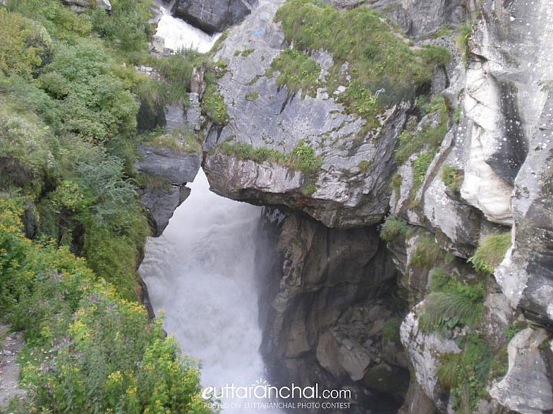
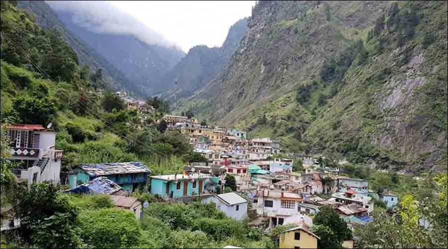
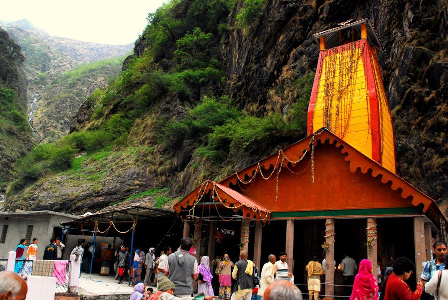
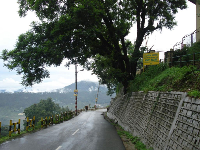
Known as Uttarakhand’s Kashi, Bageshwar is a small town situated on the confluence of the Saryu and Gomati rivers and surrounded by the mountains of Bhileshwar and Nileshwar to its east and west and by the Suraj Kund in the north and Agni Kund in the south. The Baghnath temple Baghnath dedicated to Lord Shiva finds a mention in the Puranas and the Shivratri and Uttrayani fairs are celebrated in a big way here. Bageshwar was a major trade mart between Tibet and Kumaun, and was frequented by the Bhotia traders, who bartered Tibetan wares, wool, salt and Borax in exchange for carpets and other local products in Bageshwar. The trade routes were, however, closed after the Indo-China War of 1962.
The Bagnath Temple in the middle of the town of Bageshwar derives its name from the incident of the celebrated sage Markandeya being visited Lord Shiva in the form of a tiger. Bagnath, literally translates to the Tiger Lord, Constructed in 1450 by the then ruler of Kumaon, Laxmi Chand, the temple stands at the breathtaking point where the river Gomati and Sarayu converge. Every year in the memory of the sage being visited by the god, a fair is held thronged by thousands of people who come to take a dip in the holy waters. The entrance is head lined by huge bells, which reverberate throughout the day, owing to the wish granting ability of the tiger-god. About 8 km from the town, one can pay homage to one of the few holy shrines in the city, that are located inside a natural cave, which is the Gauri Udiyar. About 2 km away from the town, the Chandika Temple is known to attract hoards of followers during the nine day long festival of the Hindu female deity, Goddess Durga. Vijaypur, located about 30 km away from Bageshwar, is a place where people come to enjoy the view. Vijaypur is surrounded by many peaks and has nice plain areas around. A tiny hamlet near Bageshwar, Bigul offers amazing views of the Himalayas including the Nanda Devi and Panchachuli peaks. This place is also important historically as Britishers used Biguls which is a form of instrument used for announcements here to call nearby villagers in order to collect taxes from them. The Dholinaag Temple is an important temple for the locals and is located at the highest point of the village.
Our next destination is Chamoli which is about 230 km from Bageshwar.
Also referred to as the Abode of Gods, Chamoli sits in the lap of nature and has a strong bond with spirituality, as seen from local legends. Home to temples across the entire village, this beautiful place is also renowned as the birth place of the Chipko Movement. Due to its surroundings, Chamoli attracts explorers and nature-lovers. Chamoli’s natural trails and laid-back lifestyle make it a perfect destination for all those who want to take a break. Mana, the neighbouring village, is power packed with a similar atmospehere, promising nature, Hindu shrines and some amazing trek trails.
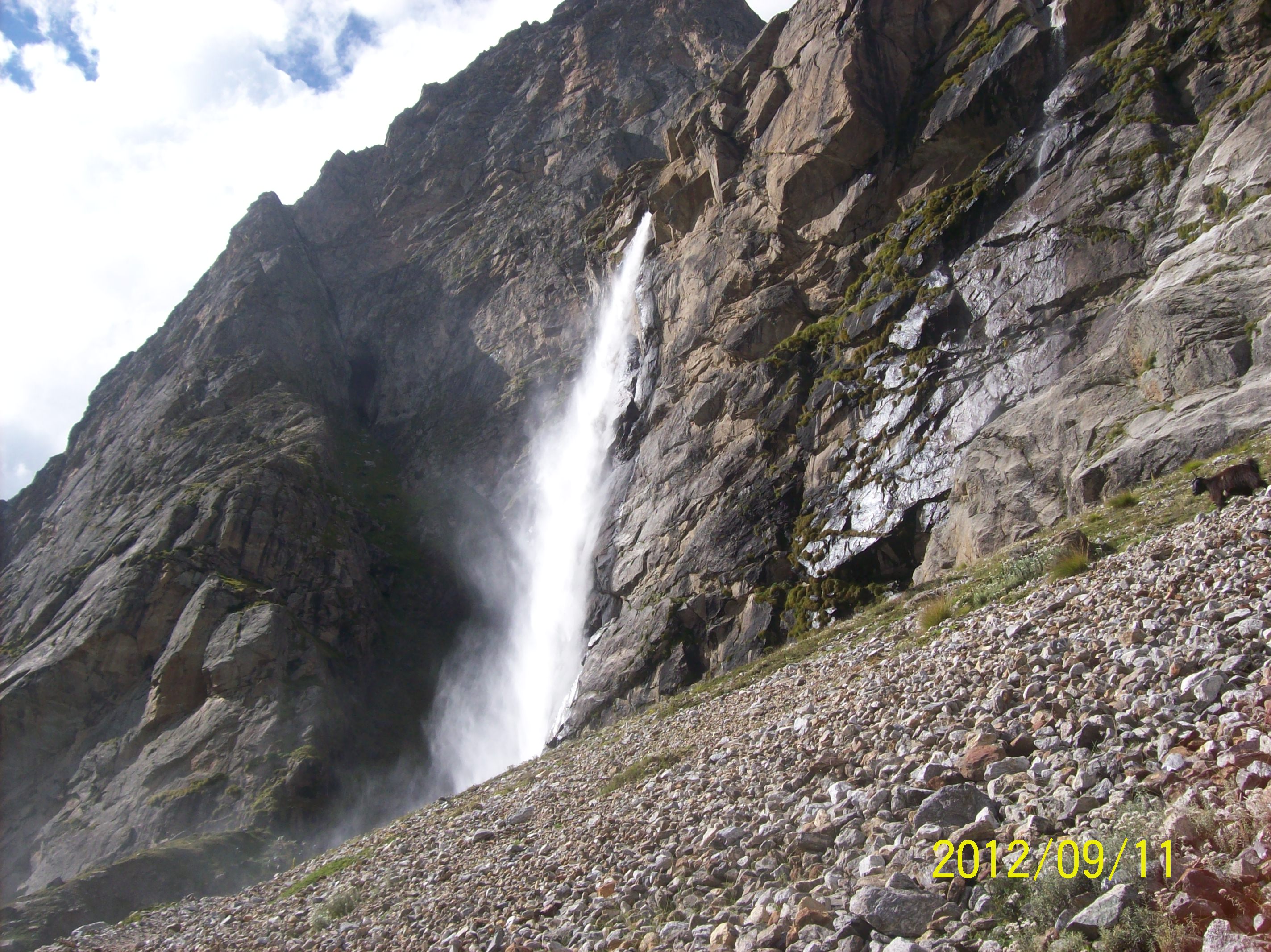
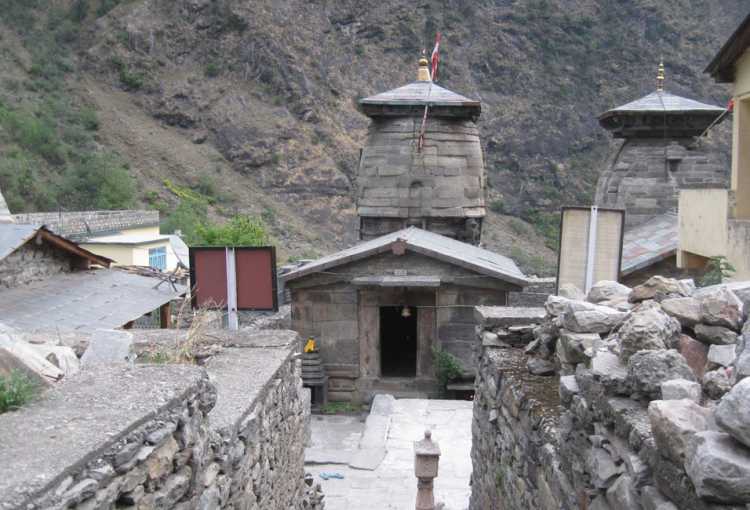
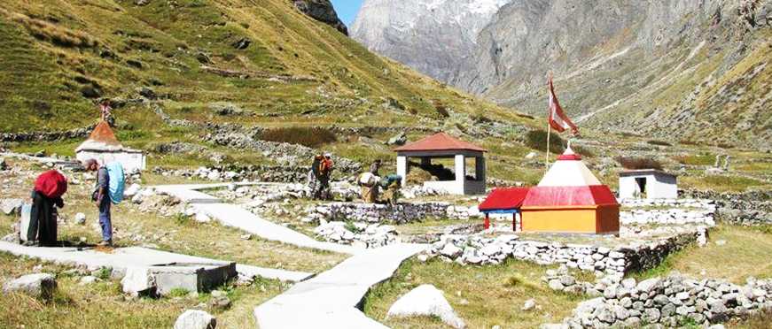
The Vasundhara Waterfall is a captivating sight and offers bewitching views of the mountain peaks and glaciers. Situated 5km from Mana, it is said that is you have committed a sin, the fall will divert that away from you. Gopeshwar is a small scenic town known for its scenic beauty and ancient Hindu temples. Perched at an elevation of 1,400 m above the sea level, here visitors can enjoy the splendid views of the Garhwal Himalayas laden with the dense vegetation of the deodar and pine trees that surround this small town. According to the local beliefs, Gopeshwar is named after Lord Krishna. Gopeshwar is famous for its Shiva temple, Anusuya Devi temple, Chandika Devi temple and the Gopinath temple. The small town holds a great mythological and religious value for local Garhwalis. The hamlet is surrounded by four famous temples dedicated to the Hindu gods – Tungnath, Anasuya Devi, Rudranath, and Badrinath. The Tungnath Temple is the highest temple of Lord Shiva in the world. The Anusuya Devi Temple is dedicated to Goddess Sati and is considered to be one of the avatars of Mata Parvati. Rudranath is another temple dedicated to Lord Shiva surrounded by the holy kund with the backdrop of mighty Himalayas. Badrinath is the holy shrine dedicated to Lord Vishnu and is also one of the temples of the famous Char Dham Yatra. Due to the number of holy shrines, many devotees visit Chamoli and offer their prayers to these religious places. The Gopinath temple, built by Raja Saggar is dedicated to Lord Shiva. As per legend, the king saw a cow squirting milk on the Shiva Lingam daily and he constructed a temple there. One of the famous Panch Kedars, Kalpeshwar is famous for the Kalpeshwar Temple which, is dedicated to Lord Shiva in one of his five forms or Kedars. Perched at an altitude of 2400 meters, Kalpeshwar is a breathtaking place with amazing views of the Himalayan peaks and is quite an experience. The last Indian settlement on the road to Tibet, Mana stands at an elevation of 10,500 feet. Winters in Mana go as low as -17 degrees celsius at Mana. Also famous from the Indian epic of Mahabharata, Mana in Uttarakhand is believed to be the same spot the Pandavas walked through the village before Bheem built a bridge on River Saraswati for Draupadi to cross the river. The Mana Pass was the ancient trade route between Tibet and India which from Badrinath to Guge town in Tibet. The trade route was fully functional till 1951 when it was shut down by the Chinese, though in 1954, via an agreement pilgrims and other travellers were allowed to travel this path. Deo Tal is the sacred lake situated atop the Mana Pass. The lake is considered holy and of great religious importance by the Hindus since it is believed that the mythical Saraswati river originated from here. You can also see Rajas Tal and Nag Tal in the vicinity. Known as the Lake of the Gods in Sanskrit, the lake remains frozen for most part of the year and is surrounded by icy peaks.
A short drive from Mana lies the holy town of Badrinath which is less than 5 km south of Mana.
Getting its name from the Badrinath temple, dedicated to Lord Vishnu, the town is a major pilgrimage site re-established by Adi Shankara in the 8th century. A sacred site for followers of the Vaishnav tradition, the temple is open for six months every year, between the end of April and the beginning of November, because of the extreme weather conditions in the region. It is one of the four Char Dham and Chota Char Dham pilgrimage yatras and is one of the most visited pilgrimages in India. Placed between Nar and Narayan mountain ranges, Badrinath Temple is situated in the backdrop of the mighty Neelkanth mountain and is known for stunning natural beauty. The temple has been repeatedly destroyed by earthquakes and avalanches. As late as WWI, the town consisted only of 20-odd huts used by the temple’s staff, but the site drew thousands each year and up to 50,000 on its duodecennial festivals which occurs every twelve years. Situated at the height of 10,279 feet, there is no historical record about the temple, but there is a mention of the presiding deity Badrinath in Vedic scriptures and according to some accounts, the temple was a Buddhist shrine till the 8th century when Adi Shankara converted it to a Hindu temple. The temple houses a black stone idol of Lord Vishnu which is 1m tall and is considered to be one of the 8 swayam vyakta kshetras or self-manifested statues of Vishnu. It also finds its mention in the 108 Divya Desams devoted to Lord Vishnu in India. The temple is closed for worship on the auspicious day of bhatridwityia in October. On the day of the closure, an Akhanda Jyoti lamp is lit to last for six months and the image of Badrinath is transferred to Narasimha temple at Jyotirmath. Badrinath reopens on Akshaya Tritiya, an auspicious day in April every year. Badri refers to a berry that was apparently said to grow abundantly in the area, and nath means Lordor Lord of as per context in which it is referred. Badri is also the Sanskrit name for the Indian Jujube tree, which has an edible berry. Some scriptural references refer to Jujube trees being abundant in Badrinath. The Badrinath Temple has a Tapt Kund, a hot sulphur spring which is considered to have medicinal values. The river Alaknanda is known to originate from here and the vibrant festivals of Mata Murti Ka Mela and the Badri Kedar festivals give you another reason to visit the temple. Badrinath is accessible by road and therefore driving up to this pilgrim spot is not difficult.
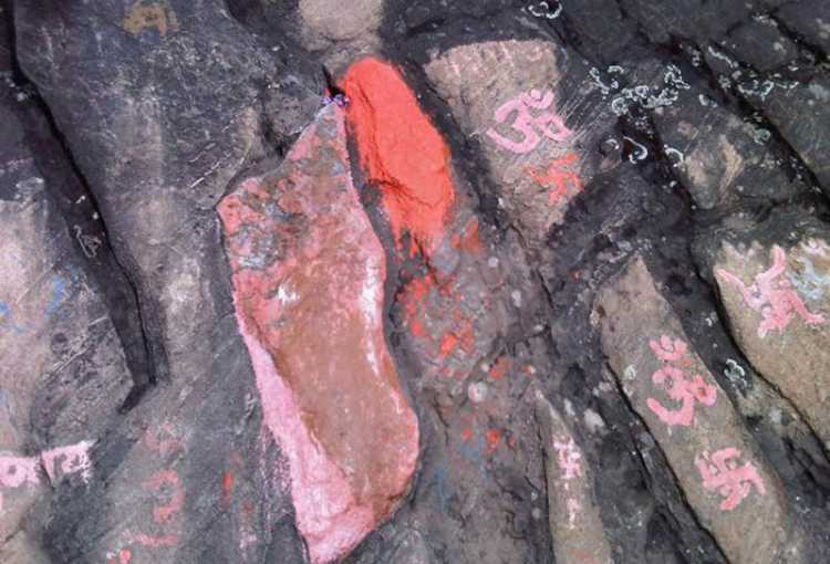
Charanpaduka: With imprints of what is believed to be Lord Vishnu’s footprints, Charanpaduka is a rock at a height of 3,380 ft, located 3 km from Badrinath on Narayan Parvat, reached after an arduous trek. This boulder is deemed as a religious site visited by hundreds each year as it is believed that Lord Vishnu set his foot first on earth here. It is believed that Lord Vishnu descended on earth from his celestial abode, also known as Vaikuntha and his steps were on the hill called Narayan Parvat, near Badrinath and left an everlasting imprint of his feet. There is also a legend traced to the Bhagwat Puran, where Uddhav, a nobleman in Lord Krishna’s court meditates for a benediction from Lord Vishnu so that he can get rid of his wrongdoings, Vishnu eventually comes down to bless him with his footprint.
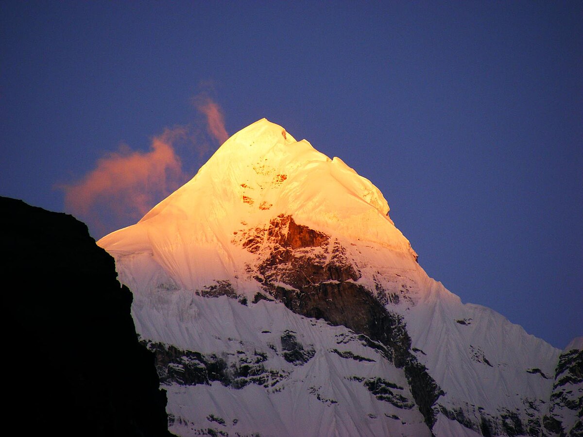
Neelkanth: Also known as Nilkantha, Neelakant, Nilkanth or Nilkanta, the Neelkanth is a major peak in Garhwal. At a height of 6507 ml, it is one of the most important and religiously revered peaks of the region due to its close proximity to Badrinath. It overlooks the lovely valley of the Alaknanda River. The snow-covered peak rises dramatically against the background of the crisp blue sky and presents one of the most beautiful sights that the region had to offer. Neelkanth lies in the midst of a medley of glaciers. The Satopanth Glacier lies on the northwest side of Nilkantha, while the Panpatia Glacier lies to the southwest, and feeds the Khirao Ganga, a stream running under the south of the peak. To the west of the peak, lies the Gangotri Glacier and its adjacent peaks while the Nanda Devi groups and Kamet lie across the Alaknanda Valley. Nilakantha’s origin may be seen as Nila means blue, Kantha means throat which is Hindu deity Shiva’s many epithets. As per Hindu mythology, there were initially no mountains on the spot where Nilkantha stands today. There was an old route between Kedarnath and Badrinath and the worshiper of the two temples worshipped them in one day. This continued for a long time until due to some sins of the worshiper, Lord Shiva became displeased with him and stood blocking the way as a huge sky-kissing mountain, which is said to be modern Nilkantha.
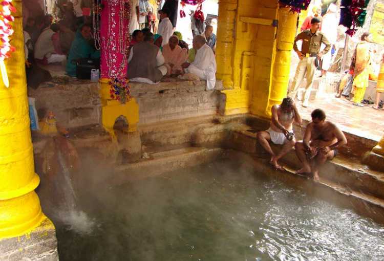
Tapt Kund: Believed to be the home of Lord Agni, the God of Fire,Tapt Kund is a natural hot water spring near the Badrinath Temple, heating to 45 degrees celsius. Located by the Alaknanda riverbank, visitors can take therapeutic baths here. The water of the kund is believed to have medicinal properties, curing various skin diseases. Devotees take a dip in the Tapt Kund before visiting Badrinath Temple. Known to purify the soul, pilgrims flock to this Kund to relieve themselves of their sins, known as the Agni Teerth. Mythologically believed to have originated from Lord Shiva’s Kapala or head, the Kund’s thermal energy is said to be much greater than most water bodies and the kund bathing area has separate arrangements for men and women.
Bheem Pul: A natural stone bridge on the river Saraswati, Bheem Pul is believed to be discovered by Bheem, one of the Pandav brothers while they were passing by. Some say the bridge was created by a stone Bheem threw between the mountains to create a path to cross the river. Nevertheless, the stunning natural bridge and the fierce river Saraswati gushing through it is a breathtaking sight.
Narad Kund: A hot water spring and holy site near Badrinath on the recess of the Alaknanda river, Narad Kund is believed to be the place from where Adi Sankaracharya recovered the idol of Lord Vishnu. An important point in the Badrinath Yatra, the devotees take a dip in Narad Kund before visiting the Badrinath Temple. Narad Kund is situated close to the Tapt Kund and gets its hot water from the Gauri Shila. Named after the sage Narad Muni who wrote the Narada Bhakti Sutra here, the beautiful surroundings attract visitors all year round.
Saraswati River: An important part of Hinduism, the Saraswati river has been mentioned in several Vedic scriptures as the milky way that leads to afterlife or immortality. It is named after Saraswati, the Goddess of Wisdom and is a tributary of the Alaknanda river which further merges with river Ganga amidst the breathtaking natural surroundings.
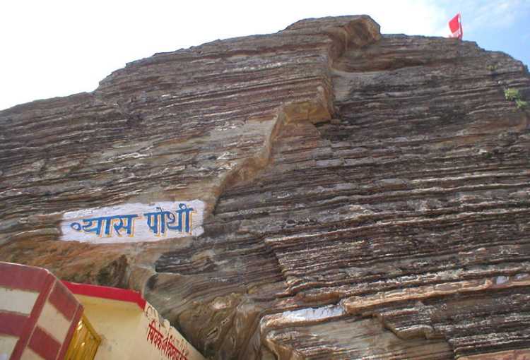
Vyas Gufa: A sacred place in Mana, Vyas Gufa is where Maharishi Ved Vyas documented Mahabharata with the help of Lord Ganesha. Many other Puranas, Sutras and Veda were also composed by Maharishi Ved Vyas in this cave. A unique feature of the cave is the roof that resembles the pages of a script.
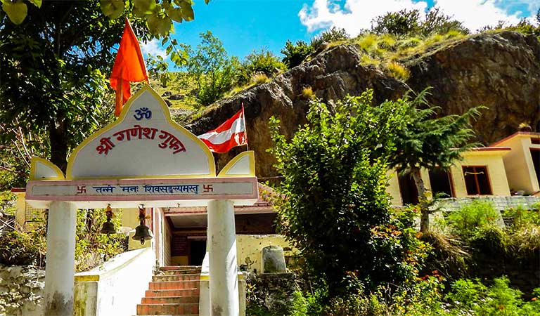
Ganesh Gufa: A naturally formed cave located at Mana, Ganesh Gufa is believed to be where Maharishi Ved Vyasa dictated and Lord Ganesha wrote the Mahabharata. The cave and the mesmerising meadows that surround it also attract nature lovers and photographers.
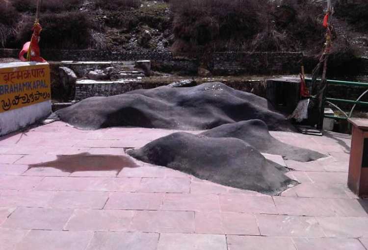
Brahma Kapal: The place where Lord Brahma is said to live even today, Brahma Kapal is the place where it is said that those who perform funeral rituals for the deceased in their family themselves attain nirvana here. Many visit the sacred site to immerse the ashes of their deceased family member in river Alaknanda, on the banks of which Brahma Kapal is located.
Yogadhyan Badri Temple: Considered the abode of Lord Kubera, the God of wealth and Lord Udhava, the Yogadhyan Badri temple is one of the seven badris. The idol of the presiding deity, Lord Vishnu is seen in a meditative pose and is believed to be installed by the Emperor Pandu, the father of the Pandavas.
Alka Puri: The source of the river Alaknanda, the majestic Alka Puri glacier with the breathtaking mountain peaks surrounding it is a treat to the eyes. Alka Puri also has a great religious significance in India as it is believed to be the holy abode of Lord Kuber, the Gandharvas and the Yakshas.
Mata Murti Temple: Dedicated to the mother of twin brothers, Lord Badrinath and Nara, the Mata Murti Temple is a sacred Hindu temple. Lord Badrinath is also known as Narayan. It is believed that Mata Murti prayed with utmost dedication to Lord Vishnu and requested him to take birth from her womb as his next incarnation. Lord Vishnu, pleased with her devotion, took birth in the form of the twins. Therefore, praying to the Goddess is believed to free one from the sufferings of the materialistic life. A fair is held every year in September at the temple on the day of Shravan Dwadashi in the honour of the Goddess.
Pandukeshwar: Located at an elevation of 6000 feet, Pandukeshwar is a sacred site for the Hindus as it is believed that this is where the father of the Pandavas worshipped Lord Shiva. The Vasudev Temple in Pandukeshwar is believed to be built by the Pandavas.
Sheshnetra: It is believed that Lord Vishnu took retreat here on Ananta Shesha. A boulder marked with the eye of Ananta Shesha is believed to have the genuine imprint. Sheshanetra is also believed to protect the region and the shrine of Lord Badrinath.
Satopanth Lake: An enchanting water body surrounded by beautiful snow peaked mountains, the Satopanth Lake is located at an altitude of 15,000 feet above sea level and is considered to be religiously important to the locals. They believe, on a particularly auspicious day, Lord Brahma, Vishnu and Lord Maheshwar bathe in the sacred waters. The natural terrain also serves as a perfect location for adventure activities, especially trekking and hiking.
After the holy temple town of Badrinath, let’s make our way to yet another holy place, this time of those who adhere to the Sikh faith, the Hemkund Sahib.
At a distance of 12 km as the crow flies, Hemkund Sahib, formally known as Gurudwara Shri Hemkund Sahib Ji, is a Sikh place of worship and pilgrimage site devoted to Guru Gobind Singh, the tenth Sikh Guru, and finds mention in Dasam Granth, a work presumed dictated by Guruji himself, but insufficiently verified, where mythological components exist in the work. With its setting of a glacial lake surrounded by seven mountain peaks, each adorned by a Nishan Sahib on its cliff, it is located in the Himalayas at an elevation of 4,160 meters. Hemkund is a Sanskrit name derived from Hem meaning snow and Kund meaning bowl. The Dasam Granth says this is the place where Pandu Raja practiced Yoga and that in a former life, Guru Gobind Singh meditated intensely at Hemkund on Mahakal Kalika. Hemkund is inaccessible from October through April because of snowbound paths and glaciers. Sikh pilgrims arrive in May and set to work to repair the damage to the path over the winter, which tradition is called kar seva or selfless service, a concept which forms an important tenet of the Sikh faith.
Travelling another 53 km west brings us to another holy temple town, the town of Kedarnath.
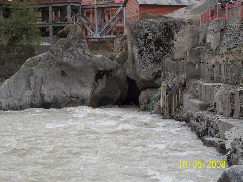
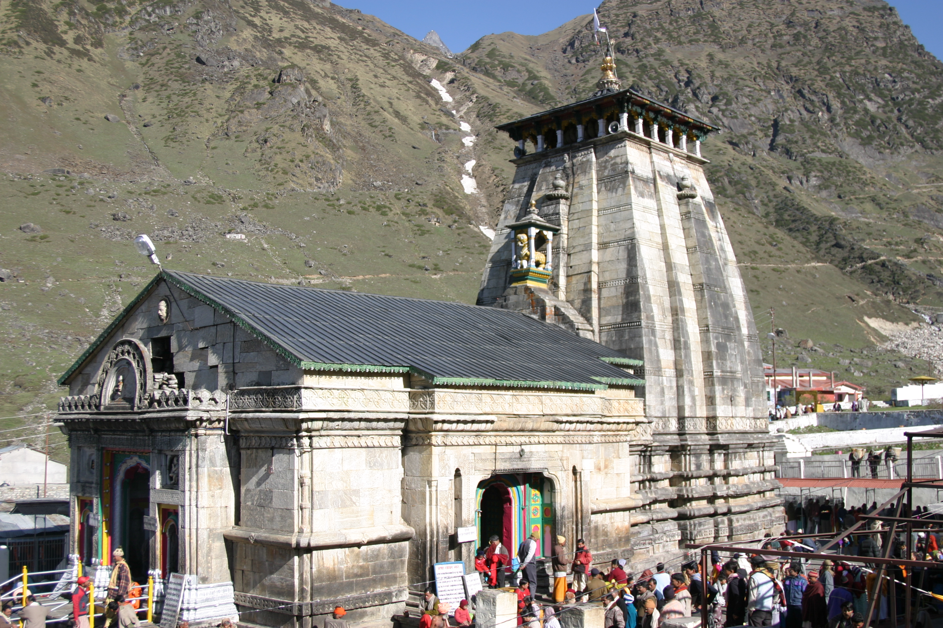
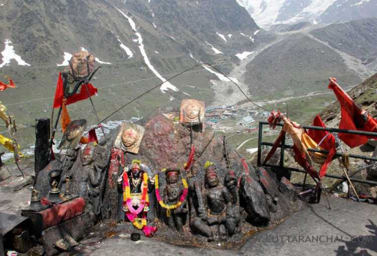
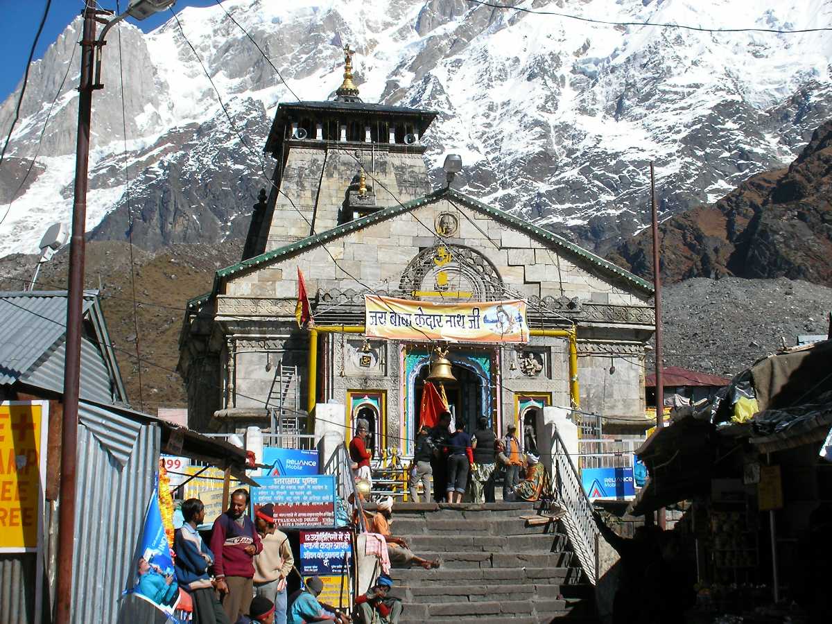
The most remote of the four Chota Char Dham sites, Kedarnath is located in the Himalayas, about 3,583 m above sea level near the Chorabari Glacier, the source of the river Mandakini, and is flanked by snow-capped peaks, most prominently the Kedarnath mountain. Kedarnath is the most important among the 12 Jyotirlingas in India dedicated to Lord Shiva. The Kedarnath Temple can only be reached from Gaurikund through a trek and remains open only for six months from April to November, due to heavy snowfall in the region the rest of the months. During the winters from November to May, the diety is shifted from the Kedarnath Temple to Ukhitmath and is worshipped there. Kedar is another name of Lord Shiva, the protector, and the destroyer, and it’s believed that a journey to Kedarnath provides one moksha or salvation. The present Kedarnath Temple is believed to be re-constructed by Adi Shankaracharya, and was initially built by the Pandavas thousand years ago from enormous stone slabs over a large rectangular dais. The name Kedarnath means the lord of the field and is derived from the Sanskrit words kedara for field and natha for lord. Kedarnath has been a pilgrimage centre since ancient times. One of the earliest references to Kedarnath occurs in the Skanda Purana, which names Kedara or Kedarnath as the place where Shiva released the holy waters of Ganga from his matted hair, resulting in the formation of the Ganges river. It is believed by some that Adi Shankaracharya died near Kedarnath, though others believe he died at Kanchi and there are ruins of a monument marking the purported resting place of Adi Shankaracharya here at Kedarnath. The town suffered extensive destruction during June 2013 from flash floods caused by torrential rains in the state.
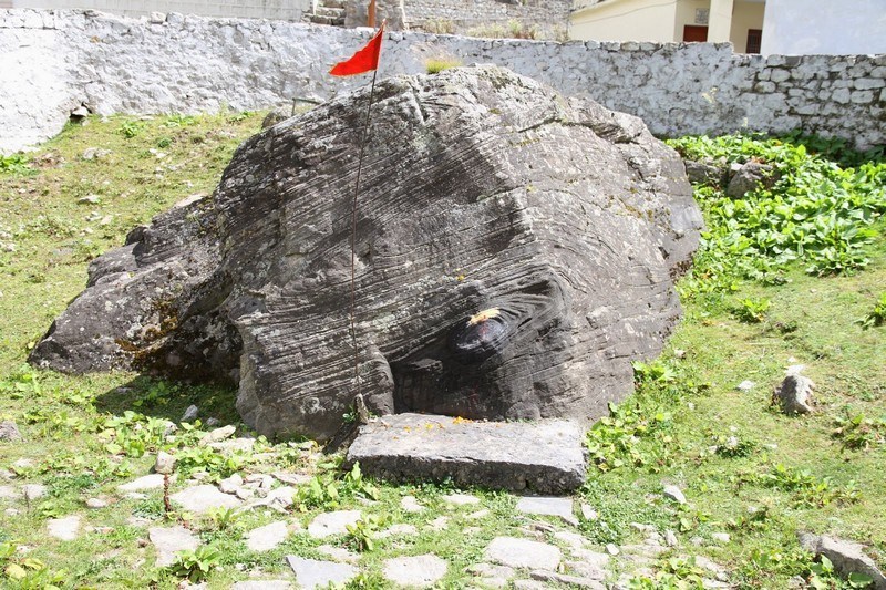
Kedarnath Temple: The Kedarnath Temple was built around a thousand years ago with massive stone slabs and stands on a raised rectangular platform. It covers an area of approximately 3 sq. km. Before the main temple, there is a low roofed hall which has images of Parvati and the five Pandavas. The walls are adorned with figures of other deities from Mahabharat. Outside the temple door, there is also a huge statue of Nandi bull which is also worshipped by the tourists and in the main temple, a conical rock is worshipped as Lord Shiva. It is believed that Kedarnath temple had been revived by Adi Shankaracharya many centuries ago. It is believed that Pandavas, after the battle of Kurukshetra, felt guilty for killing their Kaurava cousins. So, they wanted Lord Shiva to absolve their sins but Lord Shiva was annoyed with them. The Pandavas first went to Kashi to meet Shiva where they learnt that he was in the Himalayas. They proceeded for the Himalayas too but miffed Shiva did not want to absolve their sins easily. Therefore, he disguised himself as a bull and went to Guptakashi. The Pandavas reached Guptakashi too and spotted a unique looking bull. Bheema, one of the Pandavas, grabbed its tail and the bull was disintegrated in different directions. It is believed that its hump fell in Kedarnath and hence, the Kedarnath Temple was created. Another legend was when Shiva appeared before the worshippers Nara-Narayan, they requested him to stay there in his pure form for human welfare. Therefore, Shiva decided to reside as a Jyoti in the snow-clad Himalayas in a place known as Kedar. That is why he is also called Kedarnath or Kedareshwara. The temple did not suffer any major damage during the disastourus flood of 2013. In what can only be called a miraculous act, a huge rock got stuck behind the temple and protected it from the destructive floods. The temple unbelievably withstood the calamity, suffering only a small crack in one of its four walls. But the entire valley suffered a huge loss of life and property.
Bhairavnath Temple: Situated at a distance of 500 m from the Kedarnath Temple on the southern side, the Bhairavnath Temple is enshrined by the revered Hindu God, Lord Bhairava. It is perched on top of a hillock and offers magnificent views of the surrounding Himalayas and the entire Kedarnath valley below. Lord Bhairav is believed to be the main gana or devotee or of Lord Shiva and hence the temple is all the more important. The enshrining deity of the temple is also known as Kshetrapal or the guardian of the region, has a Trishul for a weapon and a dog as his vehicle.
Agastyamuni: Dedicated to Saint Agastya, the temple commemorates his one year mediation here. This ancient temple stands as an example of grand architecture and interiors with wall art adorning its walls.
Shankaracharya Samadhi: It is believed that Sri Sankaracharya who propounded the Adwaita Philosophy established this holy shrine and one of his four Mathas in the 8th century and attained Nirvana at age 32 here.
Triyuginarayan Temple: Situated at the height of 1,980 metres above the sea level, the Triyuginarayan temple is dedicated to Lord Vishnu. The temple is said to the the place where Lord Shiva got married to Goddess Parvati witnessed by Lord Vishnu. A special feature of this temple is a perpetual fire, that burns in front of the temple. The flame is believed to burn from the times of the divine marriage and so the the temple is also known as Akhand Dhuni temple. The name of the temple Triyugi Narayan is made up of three different words with Tri meaning three; Yugi means period of time and Narayan refers to Vishnu. Pilgrims have been offering wood to the fire in the havana-kund or fireplace for the past three yugs, hence the name of the temple. The uniqueness of the temple lies in the fact that devotees can worship Lord Vishnu, Lord Shiva and Goddess Parvathi at a single place. Since Lord Brahma also witnessed the marriage, the temple completes the trinity of the Hindu Gods, that is Brahma, Vishnu and Shiva. The temple also has the idols of Lord Hanuman, Lord Vinayaka, Garuda and Annapurna Devi in it. One can also find four sacred ponds or Kunds which are filled with fresh water in the temple. As per Hindu mythology, goddess Parvati was the daughter of Himavat, who was the personification of the Himalayas. She was also the rebirth of Sati. She initially tried to lure Shiva by her beauty but failed in her attempts. Later on, she practised severe penance at the Gauri Kund, which is 5 kilometres away from Triyuginarayan. Pleased, Shiva proposed to Parvati at Guptakashi and the two married in the village of Triyuginarayan. Vishnu acted as Parvati’s brother during the marriage ceremonies, while Brahma served as the priest of the wedding. The holy fire that witnessed the matrimony continues to burn in front of the temple in a fireplace till date. Before the marriage ceremony had begun, the three gods had taken a bath in the three kunds of the temple, which are the Rudra-kund, Vishnu-kund and Brahma-kund. The Saraswati-kund, which is believed to have originated from Vishnu’s navel, is the source of water supply to these three kunds. According to scriptures, devotees who visit the Triyuginarayan Temple consider the ashes from the burning fire in the Havan Kunda to be holy. Thus they add samidha, or sacrificial offerings of wood to the flame, collect the ashes as blessings and carry it back with them. It is also believed that these ashes promote conjugal bliss. The water from the three kunds is also considered to cure infertility in women, and devotees are often found taking a dip in these holy waters. The temple resembles the temple of Kedarnath and the present shrine is believed to have been built by Adi Shankaracharya. The shrine also consists of a 2 feet high silver image of god Vishnu, accompanied by an idol of his consort, goddess Lakshmi and goddess Saraswati. The exact location of the marriage is marked by a stone which is known as the Brahma Shila in front of the temple.
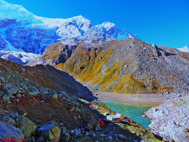
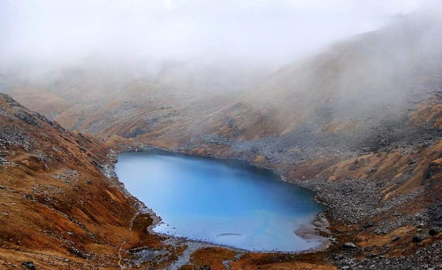
Vasuki Tal: A lake at an altitude of 4135 meters, Vasuki Tal offers a view of the neighbouring Chaukhamba peaks. Trekkers would find this an ideal range o climb up. The Chaturangi and Vasuki glaciers can be found en-route to the lake.
Chorabari Lake: Located at a distance of around 3 kms from the Kedarnath Temple, Chorabari Lake is a quaint lake which also goes by the name of Gandhi Tal. Tucked cosily in the backdrop of the mighty Himalayas, the lake is perched at a towering altitude of 3900 m above the sea level. Chorabari Tal originates from the Chorabari Bamak Glacier and can be reached through a short trek from the Kedarnath Temple. As per historical records, in 1948, the ashes of Mahatma Gandhi were also immersed in the lake. In addition to that, it is also believed that Lord Shiva used to impart sermons of yoga to the Saptarishis at the spot.
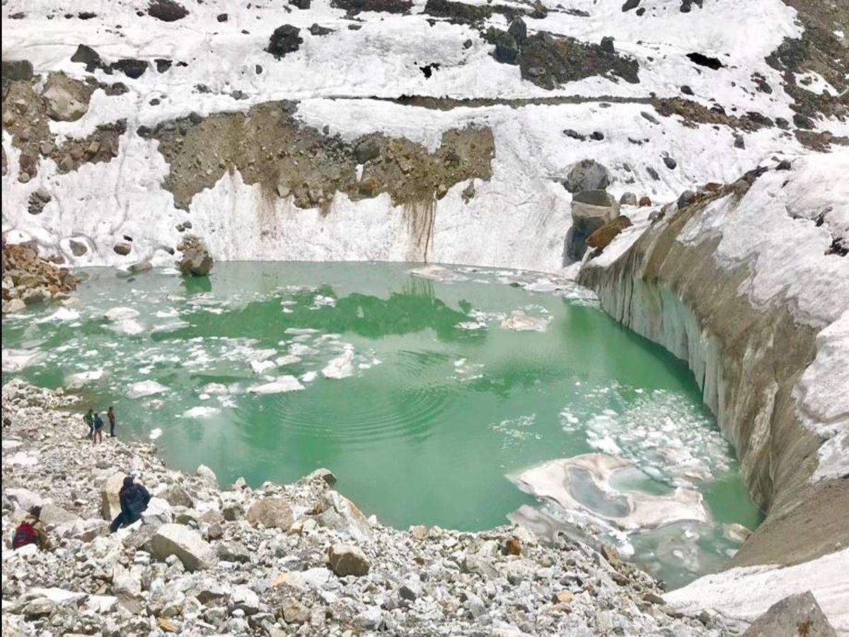
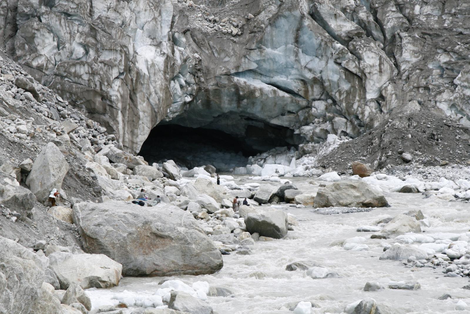
Located 21 km north of Kedarnath, our next destination is Gomukh
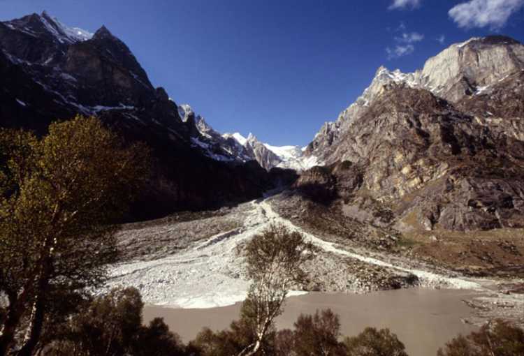
Also known as Gaumukh or Gomukh, and literally meaning the mouth of the cow, Gomukh is is the terminus or pout of the Gangotri Glacier and the source of the Bhagirathi River, one of the primary headstreams of the Ganges River. Located at a height of 13,200 ft it is one of the largest in the Himalayas with an estimated volume of over 27 cubic kilometers. On 26 July 2016, following heavy rains in Uttarakhand, it was reported that the front end of Gomukh was no more, as a large chunk of the glacier had collapsed and was washed away as huge cracks had emerged on the glacier due to the cloud burst and flash floods in the state in 2013. Prior to 2016, the opening of the cave looked exactly like the mouth of a cow. It is often considered the cradle of North Indian Hindu mythology, primarily the one centered around the river Ganges, who reincarnated on Earth upon sage Bhagirath’s insistence to purge his ancestors if their sins, so they could ascend to heaven.
Our next destination is Madhyamaheshwar, which is about 19 km southeast of Kedarnath.
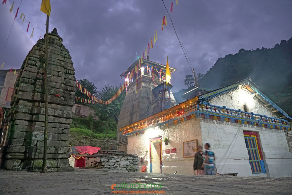
A small sacred town, Madhyamaheshwar is a place of mysteries and blessed with the bounty of nature. Dotted with small huts and villages with their own culture and unique traditions, this quaint little town has an old world charm with the snow covered Himalayas as a backdrop and sprawling alpine meadows and a thick cover of forests adding more charm to its beauty. The town is renowned for its Madhyamaheshwar Temple dedicated to Lord Shiva. Perched over an elevation of 3490 m above the sea level, visitors need to trek to this temple which is dedicated to Lord Shiva and is considered to be one of the oldest religious places in India. It is said that in order to avoid meeting with Pandavas, who came here to seek his blessing after the war of Mahabharata, Lord Shiva transformed into a bull here. Despite the uphill trek to get here, once devotees get inside the temple, they can see an idol of Shiva lingam in the shape of a naval which is placed along with the idol of Goddess Parvati and Ardhanarishwara, the form of Shiva in a half man and half woman. The temple is closed during the months of November to April during which prayers are shifted to Ukhimath. The Madhyamaheshwar Omkareshwar Temple is part of the Panch Kedar and is also dedicated to Lord Shiva. It is simply known as Ukhimath Omkareshwar Temple. During the winters, the idols from Kedarnath temple and Madhyamaheshwar are brought to Ukhimath and worshipped here for six months. Situated 2km from Madhyamaheshwar, the holy shrine of Budha Madhyamaheshwar is a cluster of rocks. The journey to this place quite captivating with picturesque views of various peaks that can be seen like Kedarnath, Neelkanth, Trishul, Kamet and Panchachuli over a small lake. Kanchani tal is 16 km away from Madhyamaheshwar, but the trek to this lake is deemed to be quite difficult, so keep that in mind.
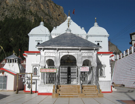
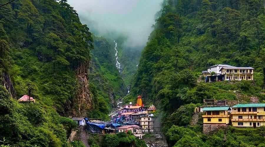
Set in the dense forests of the Greater Himalayan Range, with a mystic view that one is bound to gasp at in awe, Gangotri, at a height of 3100 m, is the origin of the River Ganga. The ancient and fascinating legend of Gangotri is that, for many centuries, King Bhagirath undertook a series of severe self-mortifying rituals as a way to show repentance of the sins carried out by his ancestors. He performed a very harsh penance, in order to bring nirvana to his ancestors who were said to have been burned to ashes due to a sage’s curse. The River Ganga, who only flowed in the heavens before this, then decided to descend into the Earth, after Bhagirath’s prolonged meditation. However, it was said that once the Ganga starts flowing, no one on the face of the Earth could stop the Goddess’s mighty tides and flow which had the power to sweep the entire planet away. It was then that Lord Shiva, on the day of Gangavataran or Ganga Dussehra, decided to rise and channelise the waters and took the Ganga in the locks of his hair and released one of the strands of his hair in Gangotri. Ganga then flowed down, in the form of 12 streams of water from here, later called its tributaries. Since then the Himalayan glacier from which Ganga emerges has also been called Bhagirathi. Ganga derives its name after the river passes Devprayag and merges into the river Alaknanda. An interesting belief around this area is that after a pilgrim comes back from Ganga darshan in Gangotri, they have to give up one piece of food forever, be it a fruit, vegetable or anything else.
The Gangotri Temple is dedicated to Goddess Ganga and is the highest and the most important shrine dedicated to the deity, perched at an elevation of over 3000 metres above sea level. It was built about 3000 years bck by a Nepalese general, Amar Singh Thapa. The architecture of the temple is traditional 18th-century architecture. Its simplicity reflects in the white granite stone that composes the entire structure. The temple stands 20 feet tall and has a Sabha Mandap that leads to the shrine where the Goddess Ganga’s Idol has been placed. The top of the temple has three main and some smaller domes or cupolas with golden Shikharas. The Gangotri temple is a simple and humble structure that withstands the extreme climatic conditions in the region. The temple is open daily from 6:15 am to 2 pm and then again between 3 to 9:30 pm. At 4238 m above sea level, the Bhagirathi glacier begins at Chaukhamba to merge into the Gaumukh. Owing to its mineral content and the terrain of medicinal plants through which it flows, it is believed that the Ganges water is extremely pure and therapeutic. It is believed that even when it is kept for years, the water doesn’t become contaminated and pretty much every Hindu home has a pot of the waters of the Ganges. Auden’s Col is a high altitude mountain pass, which connects the Rudragaira valley and Bhilangana valley and forms a bridge between north west ridge of Gangotri III and the ridge coming from Jogin I on the east. It also binds two glaciers on opposite sides, the Khatling and the glacier belonging to Jogin I. Home to the famous Himalayan trouts, this sparkling Dodi Tal lake at 3204 m. has little log cabins scattered around the lake for camping and resting. Located at an altitude of 4425 m above sea level, the Kedar lake is known for its cool waters and beautiful trek up the rolling hills spanning 18 km.
Our next destination is Gauri Kund which about 39 km south of Gangotri.
Gaurikund in Guptakashi, is famous for being the starting point to and the last road head before the Kedarnath Yatra begins. Located on the banks of the river Mandakini at an altitude of about 2,000 m, Gaurikund is a place of infinite beauty, breathtaking landscapes and immense devotion. After the disastrous floods in Kedarnath in 2013, the original trekking route from Gaurikund to Kedarnath, via Rambara, a total walking distance of 14 km, was completely washed away. However, today the trek route has improved considerably and is now absolutely safe, complete with all facilities. Gaurikund is named after the Goddess Parvati, the wife of Lord Shiva. According to popular myth and legend, Gaurikund is where Goddess Parvati did penance, which involved ascetic and yoga practices, to win over Lord Shiva. Gaurikund is also related to Lord Ganesha and the story of how he acquired his elephant head. It is believed that while taking a bath, Parvati fashioned Ganesha from the soap lather on her body and placed him at the entrance as her guard. When Lord Shiva arrived and was stopped by Ganesha, he became furious and chopped off the boy’s head. Upon Parvati’s insistence that the child be brought back to life, Shiva took the head of a wandering elephant and placed it on Ganesha’s body. The Gaurikund temple has the idol of Goddess Parvati and devotees on their way to Kedarnath make it a point to stop here. Also known as Gauri Lake, Parvati Sarovar or the Lake of Compassion, the Gauri Kund is the lake where Goddess Parvati had breathed life into Lord Ganesha. Hindus consider this lake to be a sacred spot and take a ritual bath here. Sadly, after the 2013 floods, there is only a small stream of water flowing in place of the Kund.
Our next destination is Yamunotri, which lies about 67 km northwest of Gangotri.
The source of the Yamuna River and the seat of the Goddess Yamuna in Hinduism, Yamunotri is situated at an altitude of 3,293 metres in the Garhwal Himalayas. It is one of the four sites in India’s Chhota Char Dham pilgrimage with the sacred shrine of Yamunotri, the source of the river Yamuna, being the westernmost shrine in the Garhwal Himalayas, perched atop a flank of Bandar Poonch Parvat. The actual source, a frozen lake of ice and glacier, known as Champasar Glacier is located on the Kalind Mountain at a height of 4,421 m above sea level, about 1 km further up, and is not frequented as it is not accessible; hence the shrine has been located to the foot of the hill. The mountain adjacent to the river source is dedicated to Yamuna’s father, Surya and is called Kalind Parvat, Kalind being another name for the sun deity, Surya. Yamuna is known for her frivolousness, a trait that she developed because, according to legend, Yamuna’s mother could never make eye contact with her dazzling husband. The approach to the glacier is extremely difficult and pilgrims therefore offer puja at the temple itself. Hindu mythology hail Yamuna as the sister of Yama, the God of Death, and it is believed that a bath in Yamuna can make death painless. According to another legend, sage Asit Muni had his hermitage here. All his life, he bathed daily both in the Ganges and the Yamuna. Unable to go to Gangotri during his old age, a stream of the Ganges appeared opposite Yamunotri for him.
The temple of Yamuna, on the left bank of the Yamuna, was constructed by Maharaja Pratap Shah of Tehri Garhwal. The temple is made of granite stones, topped by a conical minaret, painted in the vibrant combination of pale yellow and bright vermillion. The deity is made of black marble. Close to the temple are two hot water springs gushing out from the mountain cavities known as Gowri Kund and Surya Kund, dedicated to the Sun God, believed to be the father of Yamuna. Near the Surya Kund there is a rock pillar called Divya Shila, which is 3000 meters high, which is worshipped before puja is offered to the deity. Devotees prepare rice and potatoes, tied in muslin cloth, to offer at the shrine by dipping them in these hot water springs. Rice so cooked is taken back home as prasadam or offerings. A stone walkway leads to the temple, with a large rock formation at the entrance known as the Divya Shila, where devotees pay their respects prior to entering the temple. Influences of the 19th century Nagar style of architecture can be seen as a result of renovations undertaken by the queen of Jaipur during this period. The pujaris or priests of Yamunotri come from the village of Kharsali near Janki Chatti and are the administrators who are well-versed in the sacred texts. The temple opens every year on the auspicious day of the Akshaya Tritiya, which generally falls during the last week of April, or the first week of May. The temple always closes on the sacred day of Diwali which comes around mid-October or the first week of November, with a brief ceremony. The temple staff return to their villages and for the rest of the time the valley is gripped in silence and covered with a white sheet of snow. A base camp for some of the most exciting and major trekking trails, including the char dham yatra, Hanuman Chatti is a beautiful place situated at an altitude of about 2400 meters at the confluence of Hanuman Ganga and Yamuna River. A hot bed of hot springs and trekking, Janki Chatti is close to Hanuman Chatti and acts as an alternative base for treks to Yamunotri. Just off Janki Chatti is Kharsali, a lovely picnic spot sprinkled with a number of thermal springs, water falls and rolling meadows covered by Oaks and conifers. Lord Shiva in the Someshwar form inhabits an ancient 3-storied temple with beautiful wood work and stone carvings. A popular natural lake at 4421 metres, the Saptarishi Kund is considered to be where Yamuna originates.
Moving on, our next destination is Rudranath which is about 100 km south of Yamunotri.
To All the Boys I’ve Loved Before is the story of Lara Jean, who has never openly admitted her crushes, but instead wrote each boy a letter about how she felt, sealed it, and hid it in a box under her bed.
But one day Lara Jean discovers that somehow her secret box of letters has been mailed, causing all her crushes from her past to confront her about the letters: her first kiss, the boy from summer camp, even her sister’s ex-boyfriend, Josh.
As she learns to deal with her past loves face to face, Lara Jean discovers that something good may come out of these letters after all.
A cluster of seven fresh water lakes set against the captivating surroundings of dense oak and pine woods, Sattal offers visitors the rustic beauty of the lower Himalayas. Situated in Kumaon Region at an elevation of 1370 m above the sea level, the area boasts of its cluster of seven interconnected lakes namely: Panna, Naldaymanti Tal, Ram, Sita, Lakshman, Bharat and Sukha Tal whose sources are underground spring and which are flanked by lush green cover of oaks and pines. One of the few unspoiled and unpolluted freshwater biomes in India, the Sattal lakes are a paradise for migratory birds. With pleasant weather throughout the year, a visit to this destination away from the noise of cities is an experience not to be missed. During the British Raj, the area had a tea plantation, one of four in the Kumaon area at that time. Subhash Dhara is a fresh water natural spring that lies bundled in the dense forest of oaks. It offers its visitors a sight to behold with its pristine clear water attracting tourists in large number. The Butterfly Farm at Sattal is a museum at the John Estate that houses nearly 110 species of insect and over 2500 varied species of butterflies and was created by Federic Smetacek known as the butterfly man.
We next move on to Bhimtal, which is just about 14 km east of Sattal.
Bhimtal is an idyllic and less-crowded version of Nainital, whose charm lies in its off-beat, tranquil atmosphere. The picturesque Bhimtal Lake is a popular attraction for paddle boating, birding and nature walk. Bounded by a dense forest of oaks, pine and shrubs, it is also known for a few ancient temples. The 17th-century Bhimeshwar Temple is a must-visit spot in the hilltown. The Bhimtal Lake, with an island at the centre of the lake which houses an aquarium and a temple is a must-visit place here. A ‘C’ shaped lake over 47 hectares, the surroundings are well maintained and clean offering a pleasant experience to everyone visiting it. The lake is open from 9 am to 6 pm every day. Located on the bank of the lake is the 40-feet high Victoria Dam with its flower gardens on either side making it look quite entrancing. The Hidimba Parvat is a beautiful hill, located 5 km from Bhimtal which gets its name from Hidimba, the wife of Prince Bhima from the epic the Mahabharata. This hill also houses a wildlife asylum called Vankhandi Ashram, a habitat developed by Vankhnadi Maharaj, an environmentalist and monk who lives there. Situated on the banks of the Bhimtal Lake, the Bhimeshwar Mahadev Temple is an ancient temple dedicated to Lord Shiva. Believed to be already in existence during the visit of Pandavas while on exile, today it is often flooded with visitors. A small natural lake located about 2 km from Bhimtal, the Nal Damyanti lake contains shallow waters and is a perfect spot for enjoying some me-time. Though the trek route for reaching the lake is not very good, the amazing scenery around will make up for it. There are several old houses showcasing traditional Kumaoni architecture present here. The Karkotaka temple which is located on the top of the hill by the same name is dedicated to the serpent god, Nag Karkotaka Maharaja and this temple is especially crowded on the occasion of Rishi Panchami. Locals believe that the serpent god protects the villagers from snakes. The Folk Culture Museum at Bhimtal is an amazing place to explore traditions, culture and past of the state. Also referred to as the Lok Sanskriti Sangrahalaya, this place displays interesting artifacts, information on traditional customs and rituals and stone implements and other items of archeological importance including a fascinating collection of rock art and photographs.
Moving on, let’s make our way to Naukuchiatal, which lies less than 10 km from Bhimtal.
Naukuchiatal or the lake of nine corners is a small hill station near Nainital. The lake is 175 feet deep and is situated at 1,220 metres above sea level. It is covered in trees and shrubs also is said to have a hidden route under the lake to China. It is the deepest of all the lakes in the Nainital region with a length of the lake being 983 metres, breadth being 693 metres and a depth of 40.3 metres. Within the valley are opportunities for angling and bird watching. Other activities include parasailing, paragliding, fishing, rowing, paddling or yachting. The lake is fed by an underground perennial spring. Naukuchiatal is also known for the ‘escape festival’ which happens once every year in the month of May. It is believed that this lake was created after the hard worship of Lord Brahma and a small temple dedicated to him exists nearby. According to locals anyone performing a parikarma or circumulation of the lake will be blessed by Lord Brahma. A legend says that one glimpse of all nine corners of lake with both feet on the earth can make the viewer disappear into smoke and achieve nirvana. Lake Naukuchiatal is located at an altitude of 3996 ft above sea level and is regularly filled by the underwater stream. The lake is a magnet for numerous exotic bird species. Activities like paragliding, boating, biking, swimming, fishing and parasailing attracts tourists. Jungliagaon is a photographer’s paradise located 8kms from Naukuchiatal and is an ideal spot for angling, bird watching and wildlife photography. The Hanuman temple, also known as the Vaishno Devi temple has a 52 feet statue of Lord Hanuman at its entrance. The artificially made caves further lead to the famous Vaishno Devi Shrine which surrounds the temple and gives way to different parts. The temple complex consists of many sections like three temples in main complex, the meditation room, Shani Temple, Ram Darbar Temple and the resting area for pilgrims.
Also known as the Switzerland of India because of a similar landscape, Kausani is a hill station famous for its scenic splendour and its spectacular 300 km-wide panoramic view of Himalayan peaks like Trisul, Nanda Devi and Panchchuli. After India’s Independence, Kausani was part of the Almora district until 1997 when the Bageshwar district was carved out of Almora. Situated at an altitude of 1890m with Pine tree forests, meandering creek, Kausani is ideal for honeymooners, nature lovers and travellers. Previously known as Valna, Kausani receives snowfall during the winter months. Some of the common trek routes from Kausani are the Adi Kailash trek, the base Kausani trek and the Bageshwar- Sunderdhunda trek. The Rudradhari Falls and Caves which lie at a distance of 12 km is bounded by paddy fields and green pine forests. Located on the trekking way to Adi Kailash region, one can also explore the mysteries of the ancient caves lying near the falls. According to the legend, this place holds connection with Lord Shiva and Lord Vishnu. The Shiva Temple of Someshwar lies in the proximity to the waterfalls. The presiding deity here is Lord Shiva and it is a highly revered temple among locals. The rock-cut shrine of Someshwar is rustic and humble in construction, with the hills that surround the temple offering a unique experience. The temple has a wishing well nearby which is believed to grant all the wishes of devotees. A beautiful, quaint and sleepy village sandwiched between Garhwal and Kumaon, Gwaldam is full of forests and small lakes providing the setting for a peaceful retreat. Nestled amongst the pine forests and apple orchards at an altitude of 1700 meters, the village is tucked in the middle of Kumaon and Garhwal and offers some wide and enchanting views of peaks such as Nanda Devi, Trishul and Nanda Ghuti. There are dazzling hills covered by tall pine trees, terraced farms on the enchanting hill slopes and little wooden houses scattered in the middle of it as far as the eyes can see. The entire area is full of orchids rendering the whole scenery charming. The most famous trekking expedition here is the Roopkund Lake trek. Another beautiful ancient town tucked in the eastern half of the Garhwal Himalayas, Baijnath is popular for the Baijnath Temple and other ancient temples, a lot of which are now in ruins. Situated in the easternmost corner of Uttarakhand on the banks of River Gomti Baijnath was the capital of the erstwhile Katyuri Kingdom. The temple which is the heartbeat of the town is dedicated to Lord Shiva and was built around the 12th century and is remarkably well preserved. The Kausani Tea Estate located 5 km away from the main town is spread across the area of 208 hectares arranges short tours to show their process guided by their staff. One can also taste and buy different flavored tea. Note that it is closed from November to March. The Sumitranandan Pant Museum in Kausani is the place dedicated to the famous Hindi poet who was born in Kausani. It offers a wide range of his creative work on display from manuscripts of poems and draft work of her literary work to his awards and letters written by and to him. There is also a large collection of his books in English and Hindi showcased in a glass shelves. To celebrate his birth anniversary, every year a poetry discussion is organised in the museum. High up in the majestic Himalayas at Kausani, lies the Stargate Observatory, dedicated to the observation of celestial objects. Located at an altitude of about 1800 meters, visitors can get spectacular views of the Himalayas from here and engage in stargazing and learn the nuances of astrophotography. The observatory is open from 5:30 am to 11:30 pm and has an entry fee of INR 100 per pax.
Our next destination is Ranikhet, about 60 km south of Kausani.
Ranikhet, meaning the Queen’s Farm is a hill station developed by the British around ancient temples, undulating Himalayan hills and forests. Maintained by the Indian Army, it is the home for the Military Hospital, Kumaon Regiment and Naga Regiment and lies at an altitude of 1,869 m above sea level and within sight of the western peaks of the Himalayas. Ranikhet is popular for its views of the Nanda Devi Peak, trekking ranges, mountainous climbs, golf courses, orchards and temples. Giving a glimpse of the majestic Sonya peak, Majhkhali en-route to Almora is endowed with scenic beauty and lovely weather. About 6 km from Ranikhet is the small town of Kalika which is surrounded by thick, lush green forests and snow-capped mountains and is famous for the Kalika Temple and golf course. The backyard of the erstwhile Katyuri kings, Manila today is home to the popular Maa Manila devi Temple and this small town is a mesmerising place with wide and panoramic views of the Himalayas. Dwarahat is an ancient town full of beautiful temples which is just 35 km from Ranikhet. Home to some 55 odd ancient temples built in the medieval ages by the Katyuri Kings, Dwarahat is not only historically significant, but these temples house some of the most revered deities in Hindu mythology.
Ranikhet is home to numerous sunset points that offer wonderful views of the snow covered Himalayas. The best ones among them are Machkhali, located near woodvilla point between the Transit Camp and Ganiadeoli and the one on the road from Jhoola Devi Temple to Bhargaon. The place is best visited between February and November to witness these breathtaking mountains and sunsets in all their glory. An artificial lake surrounded by idyllic forests, the Bhalu dam is the perfect spot for a picnic complete with birds, breeze and snow-capped valleys. However, the water is typically low or negligible except during monsoon season and one needs to trek for 3 km to reach this reservoir. Originally built for rainwater harvesting, the Rani Jheel is a vast artificial lake that is located amidst natural ridges and woods and is located at an altitude of 7,500 feet above sea level. Dedicated to Haidakhan, who is believed to be an incarnation of Lord Shiva, the Haidakhan Bababji Temple was constructed by Haidakhan himself. Other than the main temple, the complex also has five guest houses, along with an Italian temple, Sri Babaji’s Kutir and the Sri Baba Research Hospital. The temple is a must visit during Navratris and in the evenings on all days. Situated near the Chaubatia Gardens, the Ram Mandir is perched on the top of a hill and can be reached by using a flight of stairs. The temple also has a monastery where students learn ancient Vedas and Vedic and modern mathematics under the tutelage of Sant Sri Mouni Maharaj. The Binsar Mahadev Mandir is an ancient temple in Bisaona built by King Pithu in the 10th century, and is dedicated to Lord Shiva, who is worshipped as Bindeshwar in the temple. One can also find the idols of Lord Ganesha, Goddess Gauri and Goddess Mahisasuramardini in the temple, along with the idol of Mahisasuramardini. Also known as Katarmal, the Sun Temple in Ranikhet dates back to over 800 years, and can be reached by a small yet exciting trekking route. The temple is surrounded by a total of 44 small shrines with ancient architectural patterns and exquisite stone carvings. The Dunagiri Temple is a famous shrine dedicated to Maa Dunagiri or Maa Durga and is located 8000 feet above sea level and is known as a Shakti Temple. People often visit this temple during the Chaitra and Ashwin months of Navratri. It is believed that when Lord Hanuman was carrying the mountain with the Sanjeevani herb for Lord Laxman, a piece of it fell on this location and since then, it has been called Doonagiri. Visitors need to climb a total of 365 steps to reach the temple. Dunagiri is one of the two Vaishnavi Shakti Peeths, the other one being Vaishno Devi temple in Jammu and Kashmir. The Kumaon Regimental Centre was built in the 1970s to showcase the rich legacy of the Kumaon region. Established by Kumaon Regiment of the Indian Army, the museum houses war artefacts of historical importance that exhibit the glory and achievements of the Garhwal and Kumaon regiments including displays of photographs of wars, weapons used by the armed forces, medals and uniforms as well as flags, stone tablets and other objects. It also houses valuables such as silver sceptres of Rani Jhansi and documents and pictures associated with Kargil War, a wireless field telephone used in World War II by the Japanese and Chinese rifles captured in the 1962 war. The KRC golf course is another major attraction.
Considered the cultural heart of the Kumaon region, Almora is located on a ridge at the southern edge of the Kumaon Hills of the Himalaya range. Founded in 1568 by King Kalyan Chand, Almora got its name from Bhilmora, a kind of sorrel, a short plant commonly found there. Prior to that the region was under the control of Katyuri King Bhaichaldeo who donated a part of Almora to Sri Chand Tiwari. There are also accounts of human settlements in the hills and surrounding region in the Hindu epic Mahabharata. According to local tradition, the earliest inhabitants in Almora were Tewaris who were required to supply Sorrel daily for cleansing the vessels of sun temple at Katarmal. The Chand dynasty from their inception in 953 A.D. to their ouster in the late 18th century present a saga of strife, with horrifying series of wars with rulers of Garhwal culminating in the destruction of this prosperous land and establishment of inglorious Gurkha rule. In 1791, the Gorkhas of Nepal while expanding their kingdom westwards across Kali River, invaded and overran Almora. The Gorkha rule lasted for twenty-four years. The Anglo-Gorkha war of 1814 resulted in the defeat of the Gorkhas and subsequently led to the signing of the Treaty of Sugauli in 1816, according to which, Nepal had to cede all those territories which the Gorkhas had annexed to the British East India Company. This agrarian town has two major rivers, Koshi also known as Kaushaki and Suyal or Salmali flowing through it.
Binsar: Located at a distance of 33 km from Almora, Binsar is a small town known for the beauty of the snow-laden Himalayan peaks. Set amid forests covered with oak, pine, rhododendrons and deodar trees, Binsar is home to beautiful green meadows, temples and the famous Binsar wildlife sanctuary. You can also visit Zero Point which is the highest point at an elevation of 2412 m which has beautiful views during both sunrise and sunset. One can see a 360-degree panoramic view of the Himalayas including peaks like the Kedarnath Peak, Shivling, and Nanda Devi. To reach Zero Point, one has to walk inside the sanctuary for 1.5 kilometres. A guided trek up to Zero Point is the recommended way to explore the green beauty of the Binsar Wildlife Sanctuary. It is also a great location for bird-watching. Situated at the height of 2420 metres, the weather of Binsar remains pleasant throughout the year. Besides the Binsar wildlife sanctuary, one can also visit the Kasar Devi temple and the Bineshwar Mahadev temple.
Jalna: A small and sleepy village, Jalna is the place for some trekking and exploring. A small scenic village, a few kilometers from Almora, Jalna is situated at an altitude of 1700 meters amidst the wild of the Himalayas. The sleepy hamlet is a wonderful place for trekking and exploring the natural forest cover of the area. Entry to Jalna has to be before sunset.
Kasar Devi: Splendid views of the of Himalayas, from Nanda Devi to the five snow-capped peaks of Panchachuli surround the town of Kasar Devi. The place is famous for its namesake temple, the Kasar Devi Temple. The area is home to pine and deodar trees, offering a panoramic view of the Himalayas along with an eye-pleasing view of Hawabagh Valley. A single road runs up high with 200 houses on each side. The village derives its name from the namesake deity Kasar Devi, with the Kasar Devi Temple dating back to the 2nd century. In the 1890s, Swami Vivekananda visited the place and meditated here for days and this place became a powerhouse for the counter culture that erupted in the ’60s. The region around Kasar Devi has an enormous geomagnetic field as the region comes under the Van Allen belt. The Kasar Devi fair is a large fair organised every year on Kartik Poornima as per the Hindu calendar. People often trek up to the temple from the town of Kalimath, through cosy little alleys carved in the hills.
Jageshwar: A small town with equisitely carved temples, Jageshwar has about 124 exceptionally well preserved temples. Mostly built in the 9th century, the temples will leave you feeling enchanted, with an unquenchable thirst of exploring beyond. The most visited one is the Jageshwar Mahadev Temple, situated in the Jataganga Valley, dedicated to the incarnation of Shiva in the form of a child. The story goes as Shiva being an attractive alpha male was attractive to all the women folk of the village, where he used to meditate. To not offend the men of the village, Shiva incarnated himself as a child. The temple itself is divided into two parts, with one dedicated to Shiva, and the other to his consort, Goddess Parvati. The entrance is flanked by the idols of the keepers of the sanctum sanctorum, Nandi and Skandi, complete with all the armaments, adding to the majestic bearing of the temple as well. The Mahamrityunjaya Temple is is made from three words. Maha, meaning great, mrityun, meaning death, and jaya, meaning victory. Hence the word itself literally translates to the great victory over death. The idol itself, is one of a kind carving, with no similar representation anywhere in the country. An epitome of Nagar style architecture, the Dandeshwar Temple is as tall as you can crane your neck, quite literally. It is believed to house the shrine of Lord Shiva as the staff bearer, hence the name Dandeshwar, or the bearer of the ‘dand’, the staff. The idol of the deity is in the form of a large uncut natural rock, following the prevalent custom of worshipping the Gods in their unaltered natural form. The Archaeological Museum at Jageshwar, maintained by the Archaeological Survey of India, houses an exquisite collection of the ancient carved idols and old world representations of the deities. With galleries containing pieces dating back to the 9th and 13th centuries, the most prominent figures are those of Uma and Maheshwar or Parvati and Shiva and the Sun god as well as the Nav Graha, or the nine planets. The museum is worth a visit, The most noteworthy figure is of one of the rulers of the area, Pona Raja, who is still well respected and remembered in the region.
Bright End Corner: Situated about 3 km from Almora, Bright End Corner offers breathtaking views of sunset and sunrise. This place is dedicated to Swami Vivekanand, who spent few days during his stay in the Himalayas and the viewpoint has a Vivekanand library situated very close to it.
Chitai Temple: Locally known as the Golu Devata Chitai Temple, the Chitai Temple is located 9 km from Almora City. This Temple is dedicated to Gollu or Goljyu Devta, an avatar or incarnation of Lord Shiva in the form of Gaur Bhairav, built during the Chand regime. The temple is known as the abode of the God of Justice and there are various beliefs that cause people to come and pray here. There are many bells hung by devotees as an act of offerings, wishing or thanksgiving which can be heard far and wide and this is why the temple is also called the temple of a million bells.
Katarmal Sun Temple: Located at an altitude of 2,116 m, the Sun Temple in Katarmal village is considered the second most beautiful shrine dedicated to the Sun God or Lord Surya in India. Around 19 kilometres away from Almora, this temple complex where the main temple is dedicated to the the incarnation of Lord Surya, Vraddhaditya. This shrine is lightened at dawn as it receives the first rays of the sun. Its very location amidst the Kumaon hills interrupted by the Kosi river, makes this site extremely photogenic and an absolute delight. This 9th century temple complex dates back to when Katarmalla, a Katyuri ruler used to rule the region. This 800-year-old temple has one main temple and 45 smaller shrines. Other smaller shrines have idols of Shiva, his consort Parvati, Lakshmana and Narayana, enshrined in them.
Gobind Vallabh Pant Museum: Holding some of the legacies of the Katyuri and Chand dynasties, the museum on Mall Road also has beautiful collections of folk style painting known as Aspen and Kumaoni antiquities.
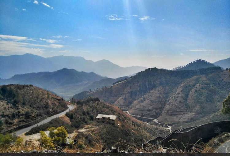
Moving on, let’s head to Champawat, which lies about 130 km east of Almora.
Champawat is an intrepid town perched 5,299 feet above the sea level and was the former capital of the Kumaon Kingdom. The place holds historical and religious significance because It is believed to be the place where the Kurmavtar or the turtle incarnation of Lord Vishnu took place. Today, there is a temple called Kranteshwar Mandir, which is dedicated to lord Shiva. It is also believed that the head of Ghatotkacha, the son of Bhima and the demon Hidimba fell here after he died in the battle of Kurukshetra in the Mahabharata with the Gahtku Mandir the temple dedicated to Ghatotkacha. There is a famous temple called the Shaani Mandir or Manokamna Purn Mandir Kaula in the village of Maurari. The only structure in the area said to have been constructed in the medieval time, Banasur ka Kila is about 20 km from Champawat. It is believed to be the capital of demon Vanasur who faced his defeat at the hands of Lord Krishna. Banasur ka Kila was constructed in the memory of Banasur, the eldest son of the mythologically famous King Bali because he was assassinated here by Lord Krishna when Banasur had tried to kill Krishna’s grandson Aniruddha. The fort is based on the name of a boon-bestowed Banasur, the man with the thousand arms; whereas the fort gives an air of disintegration and dilapidation.
The Lohawati River also originates from this site and is located alongside the Bhowali Road. Ek Hathiya ka Naula is one of those structures, that is known not only because of its uniqueness, but also for its creators. A single handedly carved architectural marvel, situated about 5 km away from Champawat, Ek Hathiya ka Naula is named so, because it was literally carved by an artisan who had only one hand, over the span of a single night. One of the oldest temples in Champawat, the Baleshwar temple, dedicated to Lord Shiva was built around 10th century by the rulers of Chand Dynasty. Among the two temples in the campus, one is dedicated to Ratneshwar while the other is dedicated to Goddess Durga. An amazing example of architecture, the temple complex is mostly built of stone. The Kranteshwar Mahadev Temple which lies at a distance of about 6 kms from Champawat is a small complex of stone made structures and is locally known as the Kandev or Kurmapad. It is atop a hill at a height of 6000 meters and there is the ever blooming red blossoms in the temple complex which provide a one of its kind visual treat. The panoramic view of the temple is simply majestic and worth the trip. The Nagnath temple is a wooden carved double storey structure that is also the oldest and the most well preserved shrine of Lord Shiva. According to locals, they worships Lord Shiva in his perpetual form of the wielder of the serpentine creatures, signifying his detachment to the world, but also his love for the outcast creatures, the nag or the India cobra. The Nagnath Temple was built by Guru Gorakhnath, a noted sage of the hills. Despite the destruction caused by the Rohilla and Gorkha tribes, the temple has been restored and sports a very intricately carved wooden doorway of the 18th century Kumaoni style architecture. Gwal Devta, more popularly known as Goll Devta or Goril Devta, is a deity of enormous significance in the area, and is known to deliver justice and instill faith in his populace as their ruler prince. However, he became a victim of his cruel stepmother’s plans and was drowned in a river nearby, locked in an iron cage. His faithful people bullt the temple in his memory, and believe he still presides over the town and metts out justice to the helpless and the needy. The temple at Golchaurh receives quite a lot of pilgrims throughout the year and is held in high esteem by all devotees. Lohaghat is a beautiful hill station located near Champawat and this ancient town is an important place for temples with historical and mythological significance. Situated on the banks of Lohawati River and at an altitude of 1800 meters, Lohaghat is blessed with natural beauty in abundance. Situated at an altitude of 1500 meters in the foothills of Garhwal Himalayas, Shyamla Tal is a beautiful lake town with umpteen amounts of greenery and freshness to it. Alongside the lake there is a Swami Vivekanand Ashram which is one of the highlights of the place and is a great for some meditation and self-exploration. The lake has been named so as it looks like a mirror to the sky reflecting its blue tint all over itself.
Lets now drive 200 km north from Champawat to Munsiyari.
Often referred to as Little Kashmir, Munsiyari is a cosy hamlet located in Pithoragarh. Situated at an altitude of 2298 metres, the pretty little hill town is known for its panorama of snow-capped Himalayan Range and some adventurous trekking trails. Perched between the borders of India, Tibet and Nepal, Munsiyari is a base for three glaciers namely Namik, Milam and Ralam glaciers. The scenic village with the stunning backdrop of the Panchachuli or the five peaks, Nanda Devi and Nanda Kot is also dubbed the Gateway to Johar Valley’ as Munsiyari is the starting point of Johar Valley which was the ancient trade route between Tibet and India. In local parlance, the name Munsiyari refers to a place with snow. Situated on the banks of Goriganga river, it is commonly used as a trekking hub or base camp. Munsiyari also falls on the ancient salt route from Tibet and is at the entrance of the Johar Valley, which extends along the path of the Gori Ganga river to its source at the Milam Glacier. The upper part of Munsiyari is called Malla Johar, which comprises 14 trans-humant alpine villages, that are seasonally occupied during the months of May to early November.
Falling from the height of 126m, Birthi Falls which is located about 35 km from Munsiyari offers an extremely refreshing experience. With lush green surroundings blooming in various colors, it makes for an ideal place to sit and enjoy some time alone. A beautiful place with a very fascinating legend attached to it, Maheshwari Kund is just a few km walk from Munsiyari. Once cursed by a Yakshi who use to live in a small lake there, the place faced drought for several years. After the villagers apologized to the Yakshi for not letting him marry the sarpanch daughter and emptying the lake in form of revenge, the ritual is practiced even today and there is a pond there now offering nature in its absolutely raw form and a incredible view of Panchachuli Peak which is a prominent peak which looks majestic from Munsiyari. The Thamari Kund is an enrapturing natural lake bound by alpine and paper trees as well as many Musk Deer and enriched in variety of flora. Located at a distance of 15 km from Munsiyari on the way from Birthi, Kalamuni Top is 9,500 feet tall and famous for its Kali Temple dedicated to the Naga God. The fantastic view of Panchachuli peak from there flanked by the sprawling pine forest makes this place a must visit. Situated at a height of 9,000 ft, Betulidhar is covered with red rhododendrons in full bloom. However, the best feature of this place is absolutely gorgeous sunsets and sunrises with an entrancing view of snow covered Himalayas and the Balati and Ralam Glaciers. A small quaint village just 6km from Munisyari, Darkot is a paradise for shoppers offering a varied range of articles to buy, the most famous being pashmina shawls and sheep wool blankets. The Nanda Devi temple at Munisyari is a structure of typical Kumaoni architecture dating back to 1000 years, and naturally well preserved. The Nanda Devi Fair, that started in the 16th century, continues here, and falls every August, much to the delight to all the lovers of lesser known mythologies.
Situated in a beautiful Soar valley and flanked by Nepal in the east and Tibet in the north, Pithoragarh is a small urban town which is a prime example of raw beauty of nature. A gateway to Himalayan range, this town also serves as the stop over for pilgrims on their way to Kailash Mansarover. With the river Kali flowing through the town which is prettily adorned with tranquil temples, villages, fort, lush green forests and natural resources, this place is a blessing in disguise for travel enthusiasts. Pithoragarh and its surrounding areas were part of the Manaskhand region, which extended from the Kailash Mountain in the north to Bhabar & Terai in the south, as mentioned in the Skanda Purana. The Asuras and Nagas appear to be the earliest inhabitants of the region, who were later superseded by the Kiratas, Khasas and the Kunindas. The Kushana Kings held their sway over the region in the last quarter of the 1st century after which the region came under the Kurmanchal kingdom, which had its capital first at Jyotirmath and then at Karikeyapura which is today Baijnath in the Katyur Valley.
Upon the disintegration of the Katyuris and the fall of kingdom in the 13th century, Pithoragarh came under the rule of Bam kings of Saur. In the 15th century, King Bharti Chand of Champawat amassed a huge army, and started plundering and killing in the regions ruled by the Doti Kings. The resultant war, lasting 12 years, ended with a victory for the Chands. The kingdom of Saur came under direct control of the kingdom of Kumaon in the 16th century during the rule of King Balo Kalyan Chand, when it was gifted to him by the Raika king of Doti as dowry for marrying his daughter. Legend has it that during the reign of the Chand Rajas of Kumaon, one Piru, also called Prithvi Gosain, built a fort here and named it Prithvigarh which, in the course of time, got changed to Pithoragarh.
Chandak is a hill with an opportunity for a small trek situated on the north side of the Soar Valley. Located at a distance of 8 km from Pithoragarh, this beautiful place also offers hang gliding adventures. The Mostamanu Temple is about 2 kms away on foot. This temple attracts a lot of visitors during August and September when a fair is organized. Tucked away in the eastern corner of Uttarakhand, Didihat is a wondrous and pristine hillock full of natural beauty. The place is known for its ruins of forts and temples belonging to a bygone era as well for being a halting point on the Kailash Mansoravar Yatra. Situated at an altitude of 1800 meters, Didihat is blessed with infinite natural beauty and some great viewpoints of the mighty Himalayas. Didihat also has some remnants of its glorious past in the ruins of the forts and temples belonging to the Doti and Chand rulers and is known to provide some amazing views of mighty Himalayan peaks such as the Panchachuli and Trishul peaks. Gangolihat is famous for hosting the Shakti Peethas of Goddess Kali. A very small town located near important tourist spots such as Patal Bhuveneshwar, Binsar and Abott Mount, it is located at an altitude of 1800 meters. Nestled at an elevation of 1106 metres, the small town of Askot borders Nepal and China, and is known for its rhododendron carpeted hills, enchanting valleys, meandering streams and picture perfect settings. Enveloped by the Chhiplakot and the Panchchuli ranges, the offbeat hilly hamlet is popular for its Askot Musk Deer Sanctuary. The rocky mountains offer perfect trekking opportunities for both amateurs and professionals. Patal Bhuvaneshwar is known for its deep caves underground and is 82 km away from Pithoragarh. The Kapilaswar cave is a cave temple dedicated to Lord Shiva and offers breathtaking views of the Soar Valley and the equally bewitching sight of snow covered peaks of the great Himalayas. Situated 3 km from Pithoragarh, the cave houses many tunnels to the temple which are now closed. To worship the deity placed in the complex, one has to travel 10 m into the cave. Another temple dedicated to Lord Shiva is also situated about half a km away. Pithoragarh Fort affords spectacular views of the Kali Kumaon and was established in year 1789 by the Gorkhas after the invasion of town. Surrounded by views of the majestic Himalayas, the Dhwaj temple is dedicated to Lord Shiva and Maa Jayanti and is 10 km from Pithoragarh. Visitors can also hike to the temple which is 4 km across the terrain. A heaven for wildlife lovers and botany enthusiasts, the Askot Sanctuary has a wide range of flora and fauna. Located at the height of 5412 m and at a distance of 54 km from Pithoragarh, one can witness vivid kinds of animals like chirs, pheasants, koklas, bharals, Himalayan black bear, chukors, snow leopards and musk deers here. Apart from the wildlife, Askot is also dotted with many temples.
From Pithoragarh, our next destination is Bageshwar
In 1935, Dottie Krasinsky is the epitome of the modern girl. A bookkeeper in Midtown Manhattan, Dottie steals kisses from her steady beau, meets her girlfriends for drinks, and eyes the latest fashions. Yet at heart, she is a dutiful daughter, living with her Yiddish-speaking parents on the Lower East Side. So when, after a single careless night, she finds herself in a family way by a charismatic but unsuitable man, she is desperate: unwed, unsure, and running out of options.
After the birth of five children—and twenty years as a housewife—Dottie’s immigrant mother, Rose, is itching to return to the social activism she embraced as a young woman. With strikes and breadlines at home and National Socialism rising in Europe, there is much more important work to do than cooking and cleaning. So when she realizes that she, too, is pregnant, she struggles to reconcile her longings with her faith.
As mother and daughter wrestle with unthinkable choices, they are forced to confront their beliefs, the changing world, and the fact that their lives will never again be the same….