

Known as the Songbird of India and one of India’s easternmost states, Mizoram is the southernmost of the seven sister states, sharing borders with the Indian states of Tripura, Manipur and Assam and also international borders with Bangladesh and Myanmar.
The name of the state is derived from Mizo, the self-described name of the native inhabitants, and Ram, which in the Mizo language means land. Thus Mizoram means the land of the Mizos. A landlocked state, Mizoram is India’s fifth smallest state with the Tropic of Cancer running through the state nearly to its middle.
Like several other northeastern states of India, Mizoram was previously part of Assam until 1972, when it was carved out as a Union Territory. In 1986 the Indian Parliament adopted the 53rd amendment of the Indian Constitution, which allowed for the creation of the State of Mizoram on 20 February 1987, as India’s 23rd state. Mizoram is the 2nd least populous state in the country and covers an area of approximately 21,087 sq km, of which approximately 91% is forested.
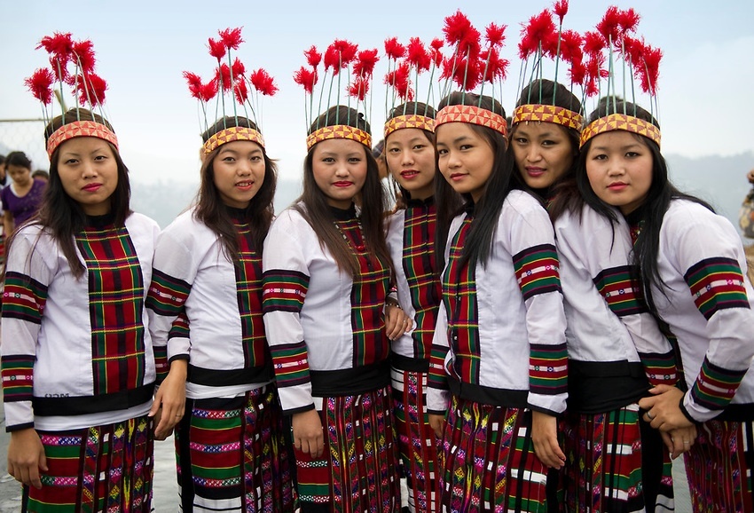
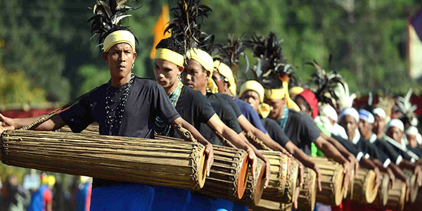
About 95% of Mizoram’s population descends from a diverse tribal origin. Mizos first began to settle in the area in the 16th century, coming in waves of immigration from Southeast Asia. This immigration lasted through the 18th century. Mizoram has the highest concentration of tribal people in India and the people of Mizoram are protected under the Indian constitution as a Scheduled Tribe. Mizoram is one of three states in India with a Christian majority with about 87% of the population following Christianity with people belonging to various denominations, mostly Presbyterians in the north and Baptists in the south. Mizoram is a highly literate agrarian economy with about 20% of the state’s population living below the poverty line.
Because of the sensitive nature of the state, so close to international borders, Indians need an Inner Line Permit or ILP to enter the state which cost INR 170 for a 15-day permit. The process to get an extension is slightly difficult. One can also get ILP documentation done at the Lengpui Airport in Aizwal.

Mizoram is derived from two Mizo words, Mizo and Ram where Mizo refers to native inhabitants and Ram means land. There is a dispute on the term zo. According to one view, zo means a highland or hill and Mizoram means the land of the Mizo people. There is also a view that says zo may also mean a cold region and therefore, Mizo may also signify people of the cold region. As with other tribes of northeastern India, the origin of the Mizos is shrouded in mystery. The people living in the Mizo Hills were generally referred to as the Cucis or Kukis by their neighbouring ethnic groups which was also a term adopted by the British. The majority of the tribes classified as Mizo today most likely migrated to their present territories from the neighbouring countries in several waves, starting around 1500. Before the British colonial rule, the various Mizo clans lived in autonomous villages with the tribal chiefs enjoying an eminent position in the gerontocratic Mizo society. The chiefs were the absolute rulers of their respective clans’ territories, although they remained under the nominal political jurisdictions of the Rajas of Manipur, Tripura and Burma.
The Mizo Hills formally became part of British India in 1895, and practices such as head-hunting were banned in Mizoram as well as neighbouring regions. The northern and southern Mizo Hills became the Lushai Hills, with Aizawl as their headquarters by declaring the whole area as an excluded area till Indian independence. After Christian missionaries arrived, the majority of the population became Christians in the first half of the 20th century.
Post-Indian independence, the number of tribal chiefs had increased to over 200 with the educated elites campaigning against the tribal chiefdoms under the banner of the Mizo Union. As a result, the hereditary rights of the 259 chiefs were abolished under the Assam-Lushai District Act, 1954. Village courts were re-implemented in the Mizo region along with other parts of Assam.
A period of protests and armed insurgency followed in the 1960s, which resulted in the Mizo National Front or MNF seeking independence from India which failed to garner public support or participation. In an attempt to counter these insurgency threats, the Indian government bombed state areas affected by insurgency, which is the only known bombing of India on its soil on 5 March 1966. In 1971, the government agreed to convert the Mizo Hills into a Union Territory, which became Mizoram in 1972. Following the Mizoram Peace Accord of 1986 between the Government and the MNF, Mizoram became a full-fledged state of India in 1987.
Geographically, Mizoram is a land of rolling hills, valleys, rivers and lakes. As many as 21 major hill ranges or peaks of different heights run through the length and breadth of the state, with plains scattered here and there. Phawngpui Tlang also known as the Blue Mountain, situated in the southeastern part of the state, is the highest peak in Mizoram at 2,210 m or 7,250 ft. About 76% of the state is covered by forests, 8% is fallow land, 3% is barren and considered uncultivable area, while cultivable and sown area constitutes the rest. Slash-and-burn or jhum cultivation, though discouraged, remains in practice in Mizoram and affects its topography. According to the Ministry of Environment, Forest and Climate Change, as of 2021, Mizoram has the highest forest cover as a percentage of its geographical area of any Indian state, at 84.53% forest.

Aizwal
Mizoram’s capital, Aizawl was officially established on 25 February 1890 and is the largest city in the state as well as the centre of administration, the state assembly house and the civil secretariat. Located north of the Tropic of Cancer in the northern part of Mizoram, Aizwal is situated on a ridge 1,132 m above sea level, with the Tlawng river valley to its west and the Tuirial river valley to its east.
In 1871–72, the disorderly conduct of Khalkom, a Mizo chief, compelled the British to establish an outpost that later became Aizawl village about 14 km from Sairang from where one could travel by flat-bottomed boat. In 1892-95 Aizawl became accessible from Silchar by a fair-weather road. The Indian Air Force carried out air strikes on the town during the March 1966 Mizo National Front uprising, following which the MNF withdrew to Lunglei. Until 1966, Aizawl was a large village but the regrouping of Mizo villages after the uprising made it become a larger town and then a city. Aizawl has become the centre of the Mizoram road network connecting the north and south, east and west of the state. More than 25% of the state’s population resides in Aizawl.
Primarily dominated by the Mizo Tribe, Aizawl and its surrounding areas are lush with rolling hills and abundant greenery. An Inner Line Pass or ILP is required for entry into Mizoram which is available in Guwahati, Silchar, Shillong, New Delhi, and Kolkata.

The Durtlang Hills is located in the northern part of Aizawl and is a popular attraction with viewpoints offering panoramic views of the capital city. One can drive to the destination and once there engage in a bit of light hiking and trekking. The best time to visit the Durtlang Hills would be in the morning when the sun is not as harsh as it would be during the afternoon.

Located in Kidron Valley, the Solomon Temple is a grand church constructed by the religious group Kohhran Thianghlim, as The Holy Church. The church was founded in 1984 and is one of the largest in the state. The Temple is a square site measuring 180 ft on each side with the interior measuring 120 ft. A verandah 30 ft wide is attached to the exterior of the main hall on all four sides and is called the porch of Solomon’s Temple. The main building has twelve main doors and above the porch are four pillars, each carrying seven stars of David, meant to represent the seven churches of the Book of Revelation. On each of the pillars is a picture of the Cross of Jesus Christ and the emblem of the Holy Church is embedded. Atop the porch is an idol of two Angels blowing trumpets which face the top of the pillar and flank the northern side of the pillar, which is now used as the main entrance. The temple has four towers, one on each corner with each tower topped with a crown, representing the Crown of Salvation, the Crown of Righteousness, the Crown of Life and the Crown of the Overcomer. Two intersecting horizontal ridges cross in the middle of the pitched roof such that when viewed from the air they form a cross, representing the new covenant. There is a park with the complex as well as a restaurant, an educational institute and a social service centre. The Salvation Army Temple has wonderful bell chimes and these can be heard throughout the city on quiet mornings.

A popular picnic spot, the Berawtlang Tourist Complex is located around 7 km from Aizwal and hosts multiple ceremonial functions and houses cottages as well as restaurants. Fairs are frequently conducted here, with various cultural activities, serving as a recreational centre. This place is

Located right in the centre of the city, the Mizoram State Museum displays the rich heritage of Mizoram. Along with the numerous archaeological artefacts, photographs and natural history specimens, an entire gallery here is dedicated to the Mizo tribes. An ethnographic museum with multipurpose collections on display, the museum has five galleries, namely the Textile Gallery, Ethnology, History, Anthropology, Natural History, and an Archaeology Terrace occupying four floors. The museum was established in April 1977 by the Tribal Research Institute under the Education Department. In 1989, it came under the Art and Culture department. The museum was earlier housed in a rented building but on 14 July 1990, it was moved to a new building.
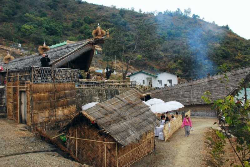
Falkawn Village
Located just 18 km south of Aizwal, Falkawn Village is a model village depicting the lifestyle of the Mizo people and is frequented by tourists. A unique cultural extravaganza for first-time visitors to Mizoram. Falkawn village depicts the livelihood and culture of the Mizo people, who form the biggest tribe in the state. The Art & Culture Department of the state government has set up a Cultural Centre or Zokhua at Falkawn in 1992 which is a mini live museum where the Zawlbuk or the dormitory, the Lal In or the Chief’s House, the Pum or the Blacksmith and other typical Mizo houses are erected. There are freedom fighter memorial stones and a Taitesena commemoration stone. Entry fees are INR 20 for adults and INR 10 for children.
