In this last part about Karnataka, let’s turn inwards towards spirituality. Today we will have a look at some of the smaller towns which are well known for their temples and other spiritual locations.
Udipi
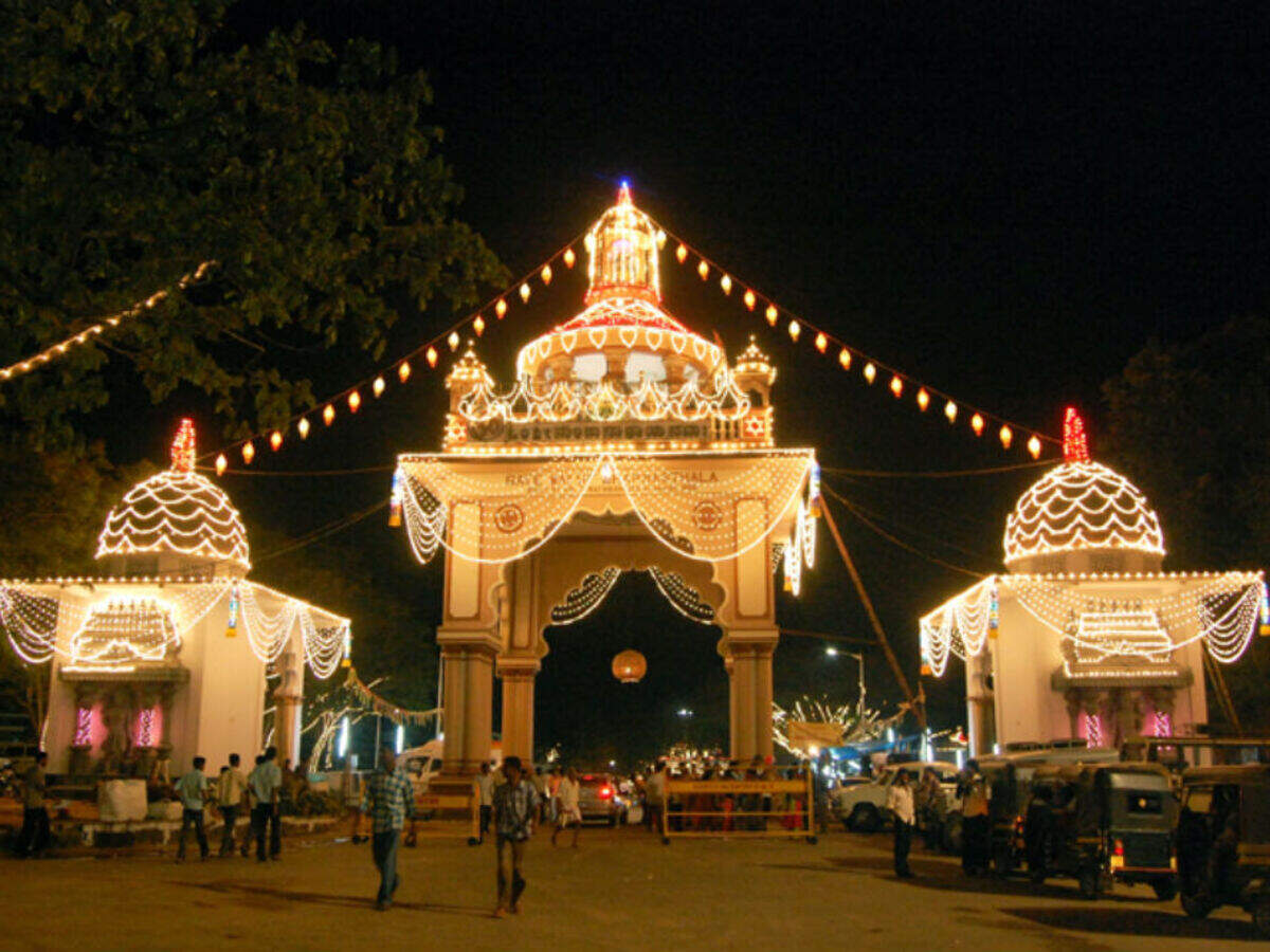
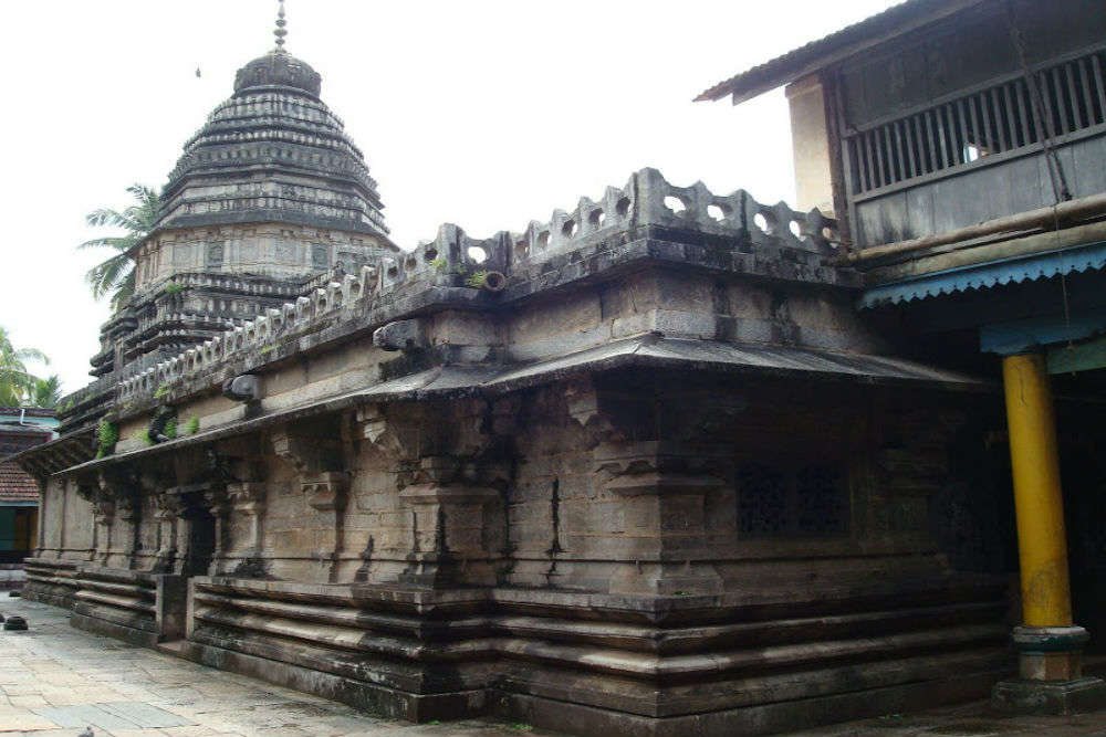
When we hear the name Udupi, the first thing that comes to mind is the string of restaurants all over India and the world that bear the name of this town. But this is also a temple town on the coast which has beautifully carved ancient temples, laidback beaches and unexplored forests. Surrounded by the Arabian Sea on one side and the Western ghats on the other, this pilgrim centre and holy town is also known as Lord Parashurama Kshetra and is famous for its Krishna Temple. Udupi is also known as Rajata Peetha and Shivalli locally.
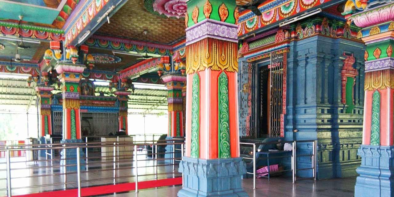
Udupi has many interesting legends intertwined with its history. It is believed that Chandra, the moon god, received redemption for his sins from Lord Shiva after doing penance here, which led to the naming of the city as Udupi. Udu essentially means star, and pa means leader – hence referring to the god of the stars or God Chandra. There are also many lores surrounding the city’s most popular attraction, the Krishna Temple. According to the most famous legend, the great saint Sri Madhvacharya was meditating on the coast when he saw a ship about to capsize. He guided the ship to safety away from the waters, and in return, the grateful sailors offered him anything he wished from the ship as a gift. The sage asked for gopichandana, or clay, which unbeknownst to the sailors, covered a majestic statue of Lord Krishna that they had been transporting from Dwaraka, which is Lord Krishna’s birthplace. Sri Madhvacharya unearthed the statue and placed it in its current place of worship in the temple. Udupi is extremely famous for its religious architecture devoted to the Gods and saints of the Hindu religion. The Krishna temple includes, in addition to its majestic statue of Lord Krishna, beautiful chariot structures or rathas. All deities in the temple face the west, and a unique feature associated with them is that they are worshipped through windows. These windows are plated with silver and have nine holes – also known as Navagraha kindi. Next to the Krishna Temple lies the Udupi Anantheshwara temple, which is believed to be over 1000 years old. It is dedicated to Lord Shiva. The city also has the Tulu Ashta Mathas, which are Hindu monasteries set up by the saint Sri Madhvacharya. These group of 8 monasteries preach the Dvaita school of Hindu philosophy.
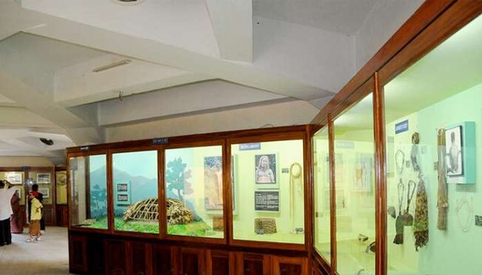
You should begin ideally with the Udupi Krishna Temple. Then, you can proceed to the famous Coin Museum, which houses an exquisite collection in the coins, from ancient to modern history. Don’t forget to visit the Shri Ananteshwar & Shri Kundeshwar Temples. Finally end your trip to Udipi with a visit to its many beaches, be it Malpe beache, Kodi beach or Kapu beach with a trip to St. Mary’s Island and it’s famous black rocks as a must see place when in Udipi.
Kollur
Kolluru or Kollur is a small temple-town near Udupi and is about 74 km north of Udipi at the foot of the Western Ghats on the banks of Souparnika river and is famous for the Mookambika temple. , a Hindu pilgrim center. Kollur also called Kolapura which is the name of a sage called Kola Maharshi . The goddess Durga is called Mookambika is said to have slain the demon Mookasura here. The goddess is described as in the form of a jyotirlinga incorporating both Shiva and Shakti. The panchaloha image of the goddess on Shri Chakra is stated to have been consecrated by Shri Adi Shankaracharya. The Divine Mother is said to be a manifestation of trigunas or triple forms such as Mahakali, Mahalakshmi & Mahasaraswati. The shikhara of the temple which is well gilded with gold is said to have been donated by Sankanna Savantha. Around the chief shrine of Mookambika, there are many other shrines. The idol of Chandramaulishvara is said to have been installed by Shri Adi Shankara and the temple has been renovated by Keladi rulers.
Legend goes that a sage, Maharishi Kola was enchanted with nature’s beauty and decided to perform a penance on a rock near the Agnitheertha. Lord Shiva, delighted with Kola rishi, appeared before him and blessed him. The Maharishi wished for the welfare of mankind and nothing else. The Lord, happy with Kola, granted him his wish. He assured that a swayambhu or autogenetic Linga would appear for his daily worship. However, Kola wanted to worship Devi also. So, a swarna rekha or a gold line appeared on the Lingam, signifying Shakti. Thus, Shiva and Shakti are worshipped together in the Lingam. Besides this, a unique feature is that the other Gods and Goddess of the Hindu pantheon also believed to reside in aroopa (non-form) in the Linga. It is thus believed to be an abode of the entire celestial congregation. It is believed that Adi Shankaracharya had a vision of Sri Mookambika Devi and installed the deity here. The legend says that Adi Shankara meditated at Kodachadri hills and Devi incarnated before him asking for his wish. He revealed his wish to install the Devi idol in a place in Kerala to worship where he wanted. Devi agreed but put forward a challenge that she will follow Shankara and he should not look back till he reaches his destination. But to test Shankara, Devi deliberately stopped the voice of her anklets when they reached Kollur whereupon Shankara turned and looked back because of doubt. Devi then asked Shankara to install her vigraha, just as he sees her, at that very location in Kollur. The original temple where Shankara meditated and Devi appeared before him is at Kodachadri peak, which is at a distance of about 20 km from Kollur and also visible as a large mountain peak in front of the temple. There also a small temple dedicated to Mookambika near Kodachadri peak
Sringeri
Commonly known as Sri Kshetra Shringeri, Sringeri is a famed pilgrimage centre nestled in the Chikkamagaluru district, mainly known for the Sharada Peetham which was built by the great Adi Shankara in the 9th century. I have written extensively about Sringeri which is the seat of the spiritual guru we follow, so do read that post for more information about this spiritual seat.
According to experts, Adi Shankaracharya stayed here for 12 years and preached to his disciples. Packed with numerous temples and ancient relics, Sringeri is a hub for Vedic learning and it attracts students from different parts of India. With a historical significance dating back to the 8th century, Sringeri rests on the banks of River Tunga. The town comes alive during the Navaratri festival and it is sheer bliss to take part in the rituals in the holy presence of the Shankaracharya.
According to popular folk tales, Adi Shankaracharya is said to have selected Sringeri to settle and preach because when he was walking by the Tunga river, he saw a cobra with a raised hood, providing shelter from the hot sun to a frog about to spawn. Impressed with the place where natural enemies had gone beyond their instincts, he stayed here for twelve years.
The name ‘Sringeri’ is derived from the name ‘Rishyashringa griri’, a small hill nearby that is said to have contained the heritage of Rishyashringa and his father Rishi Vibhandaka. As per an episode in the Bala-Kanda Ramayana, Guru Vashishtha had narrated as to how Rishyashringa had brought rains to the drought-stricken kingdom of Romapada.
Adi Shankara had created four guardian temples on all four sides of the Sringeri village-
Kala Bhairava temple in the East- dedicated to Lord Kala Bhairava, a fiercer form of Lord Shiva- representing the march of time, Kere Anjaneya temple in the West-dedicated to Sri Anjaneya, carved on a rock inside a cave, Kalikamba temple in the North – dedicated to Devi Kalikamba, a beautiful form of the Goddess and Durgamba temple in the South- dedicated to Devi Durgamba, also known as ‘Vana (forest) Durga’, owing to its remote location in the woods.
Dharmasthala
Popularly known as the Land of Charity, Dharmasthala is a beautiful temple town with a blend of heritage, culture and religion. Situated on the banks of Nethravathi river in Karnataka, it’s popularly known as a pilgrim site for the Shaiva, Vaishnava and Jaina communities.
The Dharmasthala or Manhunatheshwara Temple is an 800-year-old major pilgrimage site which houses a Shiva Linga and hosts a ‘Lakshadeepa’ – a festival of lights that takes place around November/December. The temple is a beautiful example of religious tolerance and it is maintained by Jain people and the rituals being carried on by Hindu Priests.
Another prime attraction here is the Bahubali statue, carved out of a single stone and 39 ft high. Dharmasthala has natural beauty gifted by its location, and the same is ornamented by the abundant and widespread scents of culture and spirituality in its air. Ancient archaeological artifacts like manuscripts, are stored in Manjusha Museum and are visual treat.
800 years ago, Dharmasthala was known as Kudum which was a village in South Kanara at that time. Here a Jain Chieftain named Birmanna Pergade live with his wife Ammu Ballalthi in a house named Nelliadi Beedu who were known for their generosity and hospitality. The legend has it that the guardian angels of Dharma in came down to earth in human form in search of a place where Dharma is practised and can be propagated. Impressed by their warm welcome, they told Pergade about themselves and asked him to vacate the house. Pergade and his wife moved to another home and began worshipping the Daivas. After some time, Dharma Daivas again appeared before Pergade and asked him to build four shrines dedicated to the four Daivas – Kalarkai, Kalarahu, Kumaraswami and Kanyakumari. In return, he was promised an abundance of charity and family welfare. A Brahmin priest was invited to perform the rituals who requested Pergade to install a Shiva Linga, subsequently around which the Shree Manjunath Swami temple is built.
Horanadu
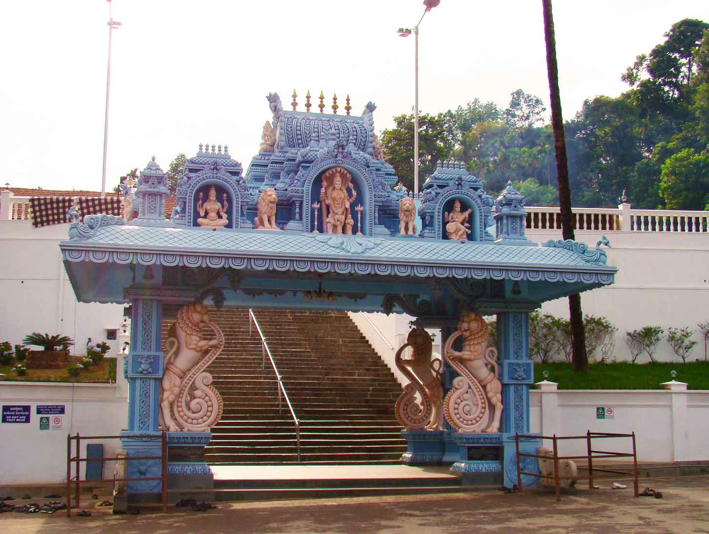
Known for the revered Annapoorneeshwari Temple, Horanadu is a holy town located in Malnad. Carpeted with green paddy fields and accompanied by a hilly backdrop, this region lies at an altitude of 2726 feet and is also famous for its extensive collection of dry fruits, cashew nuts and almonds along with tea, coffee and spice markets. According to legends, this temple was established in the 8th century by Maharishi Agasthya. Dedicated to Devi Durga, the nnine-day festival of Navratri is celebrated with fervour at the Annapoorna Temple. Also make sure you visit the Kaleseeshwara temple to payyour respects to another aspect of Lord Shiva.
Talakadu
Known as the Kashi of the South, Talakadu nestles on the banks of the River Kaveri and is a mystical place steeped with a rich past and cultural heritage. It is famous for the Vaidyanatheshwara Temple dedicated to Lord Shiva. The place derives its name from two local chieftains Tala and Kada and so is called Talakadu. There are a number of temples that are buried under the sand and are excavated once in every 12 years for special worship called ‘Panchalinga Darshana’. The Panchalinga Darshana includes five major temples namely Vaidyeshwara temple, Arkeshwara temple, Vasukishwara or Pataleshwara temple Saikateshwara or Maraleshwara temple and Mallikarjuna temple. It is said that the Pataleshwara Shivalinga change colours according to the time of the day- red in the morning, black in the afternoon and white in the evening.
Talakadu was once renowned for its more than 30 beautiful temples which were buried under the sand in the 16th century. According to the text, the burial was caused by natural disaster during the rule of Wodeyars. However, according to local folklore and myths, the town was buried under sand owing to a curse given by the queen of the region, Alamelu who drowned herself along with her jewels when the king of Mysore attacked her for her jewels.
Another legend dictates that an ascetic by the name of Somadatta was killed by elephants as he was on his way to Siddharanya Kshetra Talakadu to worship Shiva. It is believed that his disciples reincarnated themselves as elephants and went on to worship Lord Shiva at a tree in Talakadu. Two hunters Tala and Kadass truck the holy tree only to find blood gushing out of its body. Upon the instructions of a heavenly voice, the two of them dressed the wounds of the tree after which the tree healed, and Tala and Kada were granted immortality. Since Shiva is believed to have cured himself through this incident, he is referred to as Vaidyeshwara. The Panchalingas here is all associated with this legend.
The town has been a witness to the rise and falls of several great kingdoms including Cholas, Pallavas, Gangas, Vijayanagar and Hoysalas. Talakadu finds its very first mention in relation to the Ganga line of kings. The city of Talakadu, once known to house five famous Shiva temples, was the seat of power of Gangas and the Cholas. The beginning of the 11th century saw the overthrowing of the Gangas by the Cholas after which Talakadu was renamed as Rajarajapura. It was later captured by King Vishnuvardhana who established Hoysala dominance over the land for quite a few centuries. Under the rule of Vishnuvardhana, the Talakadu comprised of seven towns and five mathas. The Hoysalas were in charge of the town until the 14th century after which the town changed many hands such as the king of Vijayanagara and Wodeyars of Mysore.
Belur
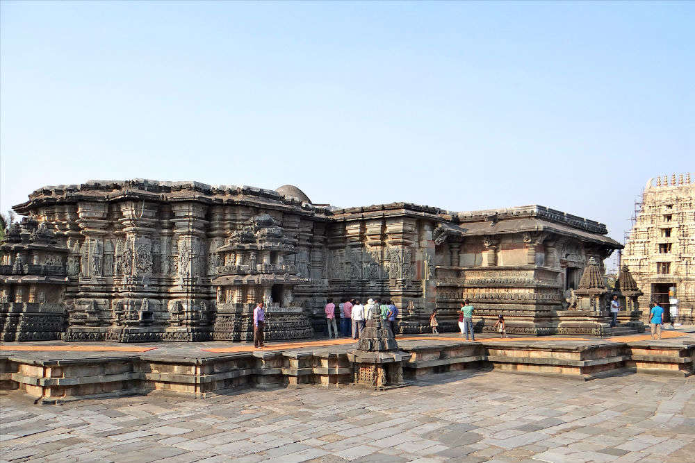
Nestled on the banks of River Yagachi in the Hassan district, the town of Belur along with its twin town of Halebid located 16 km away, houses exquisite temples reflecting the exemplary artistic taste and technique of builders of the yore. This small town was the capital of the mighty Hoysala empire and their engineering genius can still be witnessed in the structures that stand here today. Some of the important shrines that are housed here include Chennakesava Temple and Kappe Chennigaray, both of which are exemplary Dravidian pieces of architecture. Non-Hindus are allowed in the temples of Belur.
Known as the ‘Jewels of the Indian Cultural Heritage’ Belur and Halebid are adorned with the legacy of rich past and culture. Belur is mainly known for its prime attraction, the Chennakesava Temple dedicated to Chennakesava or Lord Vishnu. Legend has it that it took 103 years to complete the construction of this magnificent edifice. Standing right next to it is another temple Kappe Chennigaraya, a temple built by the wife of Hoysala king Vishnuvardhana, Shantaladevi. Apart from these, there are two other temples in the complex. Both temples exhibit the intricate detail work on the walls made up of light green soapstone. Visit this destination for a glorious look into the Hoysala engineering genius. The temple is open from 7:30 am to 5:30 pm, but the inner sanctum of the main deity remains closed between 10 to 11 am, 1 to 3 pm and then again 5 to 5:30 pm. While entrance is free, government approved guides cost between INR 125 to INR 250.
Shravanbelagola
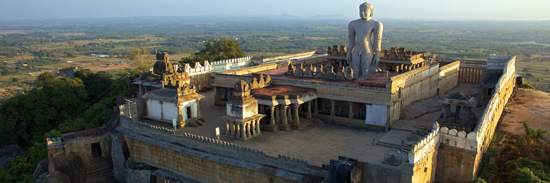
An important Jain pilgrimage centre, Shravanbelagola main attraction is the 57-m tall monolithic sculpture of Lord Gomateswara called the Bahubali statue. Located 144 km from Bengaluru in the Hassan district, this collection of Jain Temples in Shravanbelagola attracts a number of pilgrims every year. Wedged between Chandigiri and Vindyagiri hills on the side of the tank of town called ‘Belagola’. ‘Bela’ means white and ‘kola’ means the pond in Kannada. It takes a full day to visit all the monuments. For those who find it difficult to climb the hill, Dolis or Palanquin are available of INR 800 to and fro. Every 12 years, the Mahamasthabhisheka of Lord Bahubali is performed as a part of Jain culture and this a very auspicious event. The last festival happened in 2018 and it was 88th festival with the next festival scheduled to happen in 2030. The first Mahamasthabisheka was in 981 AD.
Two hills, Chandragiri and Vindhyagiri are considered to be the places where Acharya Bhadrabahu, the spiritual teacher of Chandragupta Maurya and Chandragupta, meditated. The Chandragupta Basadi, dedicated to Chandragupta Maurya, on the Chandragiri hills, was built by Ashoka, in the 3rd century BC. Chandragiri also houses many memorials of the Sravkas or monks who are said to have meditated since 5th century AD.
The 58-feet tall monolithic statue of Gomateshwara, the world’s largest monolithic statue, on the Vindhyagiri Hills, is a revered figure among the Jains. Gomateshwara, or Bhagwan Bahubali as the Jains refer it, was the first Tirthankara of Jainism. Legends say that he meditated motionless, for a year, in the standing posture and during this time, plans grew around his legs. After devoting one whole year to meditation, it is said that he attained omniscience. The statue was built by Chanvundaraya, a minister of the Ganga Dynasty in 981 AD. The Mahamastakabhisheka refers to the anointment of the Jain statues across the country and is carried out on a large scale in Shravanabelagola. Held once every 12 years, the Mahamastakabhisheka is a huge part of Jain culture and heritage. The event that takes place for weeks witnesses the veneration of the Siddha Bahubali; purified water and sandalwood paste are poured on the statue after which sanctified holy water is sprinkled on the participants by devotees who carry 1,008 specially prepared vessels or kalashas. The statue is then bathed in milk, sugarcane juice, saffron paste, and sprinkled with sandalwood, turmeric and vermilion. Offerings to the deity are made in gold, silver and other precious stones. The finale ceremony witnesses a huge shower of flowers from a helicopter.
There are numerous basadis in and around Sharavanabelagola, each dedicated to different Tirthankaras of the Jain culture. The Akkana Basadi built in the year 1181 AD, is dedicated to the 23rd Tirthankara, Parshwanath as the main deity. The Chandragupta Basadi, one of the smaller basadis, was established during the 9th century. While the middle chamber is dedicated to Parshwanath, the one to the right is dedicated to Padmavathi and the left one, to Kushmandini in the seated position. The Shanthinatha Basadi is dedicated to the 16th Tirthankara, Shantinatha, and was built by Ganga Raja, a commander during the Hoysala king, Vishnuvardhana in the year 1200 AD and is located in Jainanathapura, near Shravabelagola. The Suparshwanatha Basadi is dedicated to the 7th Thirtankar, Suparshwantha and a seven-headed snake is carved over his statue. The Chavundaraya Basadi is dedicated to Neminatha, the 22nd Tirthankara and dates back to 982. The Chandraprabha Basadi’s main deity is the 8th Tirthankara, Chandraprabha and it also depicts images of Shyama, Jwalamalini, the Yakshini of Chandraprabha, Yaksha and Yakshi who are Hindu and Jain mythical figures. Built in the 800 AD, it is constructed by the Ganga King, Shivamara II and is considered to be one of the oldest temples on the hill. The Kattale Basadi is the biggest of all the basadis on the hill and is located to the left of the Parshwanatha Basadi and is dedicated to the first Tirthankara, Rishabhanatha. Parshwanatha Basadi which was built by Puttaiya, a Jain merchant, between 1672 to 1704, depicts the tallest image of Parshwanatha, which is 18 feet in height. It is located on the Chandragiri Hill and has a manasthamba or pillar which is carved on all four sides with Padmavathi on the south, Yaksha on the east, Kushmandini on the north and a galloping horseman on the west.
Gokarna
With its pristine beaches and breathtaking landscapes, Gokarna is a coatal pilgrimage town on the coast of Karwar. Meaning cow’s ear in Sanskrit, Gokarna is said to be place where Lord Shiva emerged from the ear of a cow. It is at the ear-shaped union of two rivers Gangavali and Aghanashini. In the Shrimada Bhagavata Purana, Gokarna is mentioned as being the home of the brothers Gokarna and Dhundhakari. As per another legend, Ravana was given Atmalinga, a very powerful weapon by Lord Shiva and instructed him that it would stay permanently where it was placed first on land. While Ravana was performing a ritual, Lord Ganesha came disguised as a little boy and placed it in Gokarna. Ravana discovered that he had been deceived by the Gods to keep Ravana from getting a weapon as intense as the Atmalinga. Ravana tried to remove it, bringing about tossing the covers of the Linga to Surathkal, Dhareshwar, Gunavanteshwar, Murudeshwar and Shejjeshwar temples. Gokarna is known as one of the seven important Hindu pilgrimage centres.
Brimming with the rich history and culture Gokarna houses a number of temples dedicated to Lord Shiva and its beaches like Kudle Beach, Half-moon Beach and Paradise beach are famous. While these beaches are famous amongst the tourists, the main Gokarna Beach is only preferred by the pilgrims. According to religious customs, pilgrims must take a dip in the waters of Gokarna Beach before entering the Mahabaleshwara Temple.
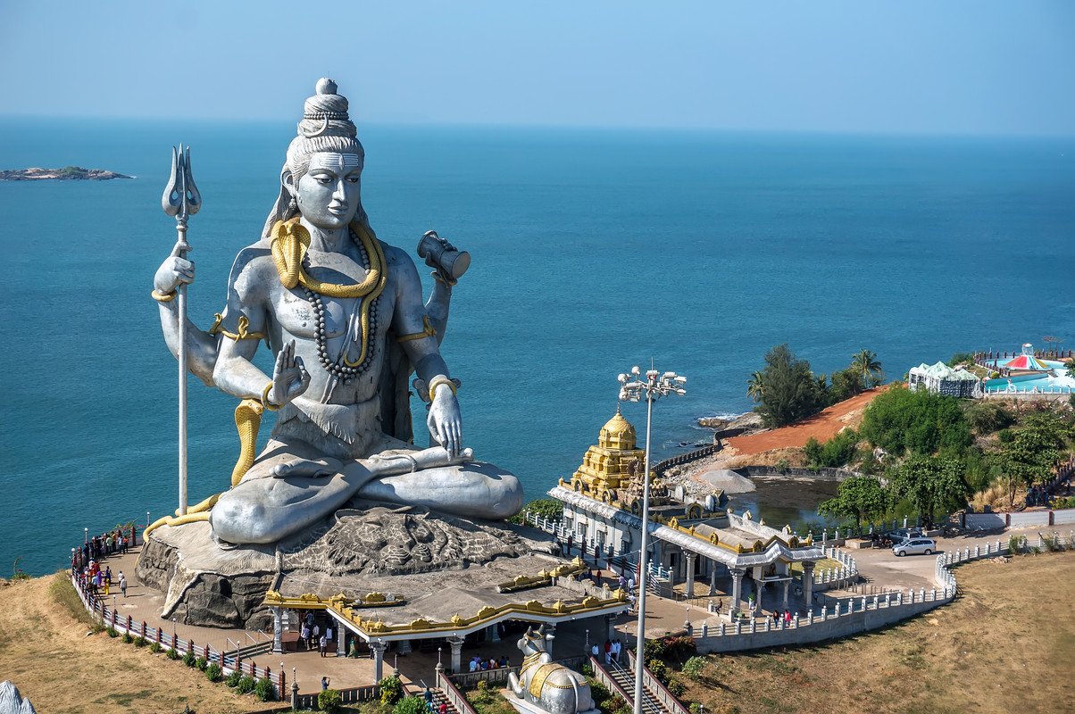
Murudeshwar
Murudeshwar is home to the second tallest statue of Lord Shiva in the world at 123 ft. Named after Lord Shiva, this town, with the shimmering Arabian Sea on three sides and the magnificent Western Ghats imposing their presence on this town. Murudeshwar temple and the fort are also the most visited spots, captivating one with their rustic charm and beauty. The Netrani Island nearby is a favourite spot for tourists as it offers excellent snorkelling and scuba diving opportunities. The Murudeshwar beach, however, has become a little overcrowded and dirty due to human intervention and could be avoided.
Dating back to Ramayana, Murudeshwara occupies a tremendous symbolic reference to the Hindu God, Lord Shiva and the ruler of Lanka, Ravana. Atma-Linga or the soul of Lord Shiva is believed to bless an individual with the power of invincibility and immortality. With the greedy idea of achieving the potential of invincibility and immortality, Ravana prayed fervently to Lord Shiva, and Lord Shiva grants him the Atma-Linga with the condition that it shouldn’t touch the ground. Later, Lord Ganesha disguises himself as a brahmin to misguide Ravana in placing the Atma-Linga as the Gods believe that this could create chaos on Earth. Finally, Lord Ganesha succeeds in his act which kindles the temper of Ravana. In the process of uprooting, parts of the Atma-Linga lands to five different spots developing a chain of temples or Panch-kshetras devoted to Lord Shiva. The Aghora or Mridesha, the covering cloth of the Atma-Linga landed on the top of Kanduka hill. This led to naming the place as Mrideshwara, which is presently known as Murudeshwara.
Koodli
The Varanasi of South, Koodli, is amongst the holiest places of southern India and the site of the confluence of two holy rivers Tunga & Bhadra. Located at a distance of 16 km from Shimoga, Koodli has been an important place of worship, meditation and peace from ancient times. The small village is home to some really important and old temples whose origin goes back to the beginning of the last millennium. The place is known as the ‘Varanasi of South’ due to the presence of temples like Rameshvara, Narasimha, Brahmeshvara, and Rushyashrama. It is also home two great philosophical schools of Hindu philosophy in the form Shankaracharya Mutt and Koodli Arya Akshobhya Teertha Mutt. The best time to visit the village of Koodli is from October till May as the temperatures during the period hover around the pleasant range of 20 to 30 degree celsius.
Srirangapatna
Srirangapatna is a small island town in the Cauvery river and located 18 kms from Mysore. The town is an architectural masterpiece of the Hoysala and Vijayanagar styles as is evident in its monuments. One of the most important Vaishnavite centres of pilgrimage, the Ranganathaswamy temple, is the major attraction of the town which draws thousands of tourists every year. The temple is dedicated to Lord Vishnu and is one of the largest of its kind. It is one of the five important pilgrimage sites of Sri Vaishnavism along the river Kaveri for devotees of Ranganatha. These five sacred sites are together known as Pancharanga Kshetrams in southern India and since Srirangapatna is the first temple starting from upstream, the deity is known as Adi Ranga or “the first Ranga”.
The temple is one of considerable antiquity. An inscription at the temple reveals it was first consecrated in 984 A.D. by a local chief called Tirumalaiah, a vassal of the Western Ganga dynasty. In the early 12th century, Hoysala King Vishnuvardhana granted the village of Srirangapatna to the Vaishnava saint Ramanujacharya as an agraharam or a place of learning. The temple is protected by the Archaeological Survey of India as a monument of national importance.
Once the capital of Hyder Ali and Tipu Sultan, Srirangapatna is home to multiple sites of historical relevance. The monuments on the island town have been nominated as a UNESCO world heritage site. This town is also notorious for being the site of the Fourth Anglo-Mysore War, which consolidated the British Empire in India and is home to the Ranaganthittu Bird Sanctuary, which houses some of the exquisite bird species.
Srirangapatna was founded in the 9th century by the Ganga dynasty, but became famous during the Vijaynagar Empire when the rulers used it as a seat to oversee the neighbouring kingdoms. Later, when the Wodeyar kings rose to power, it became the capital of Mysore state from 1610. When Hyder Ali defeated the Wodeyar kings and claimed the throne, it continued to remain the capital under Hyder Ali and Tipu Sultan. In the Battle of Srirangapatna in 1799, Tipu Sultan was killed inside the fort and that place is marked as a memorial.
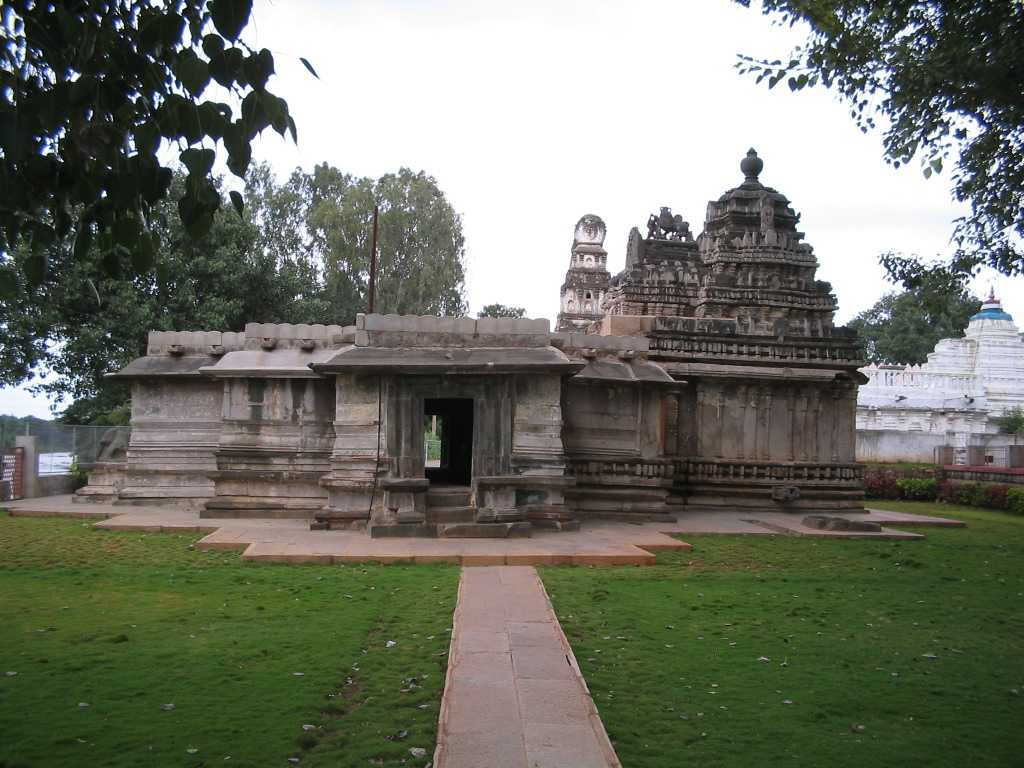
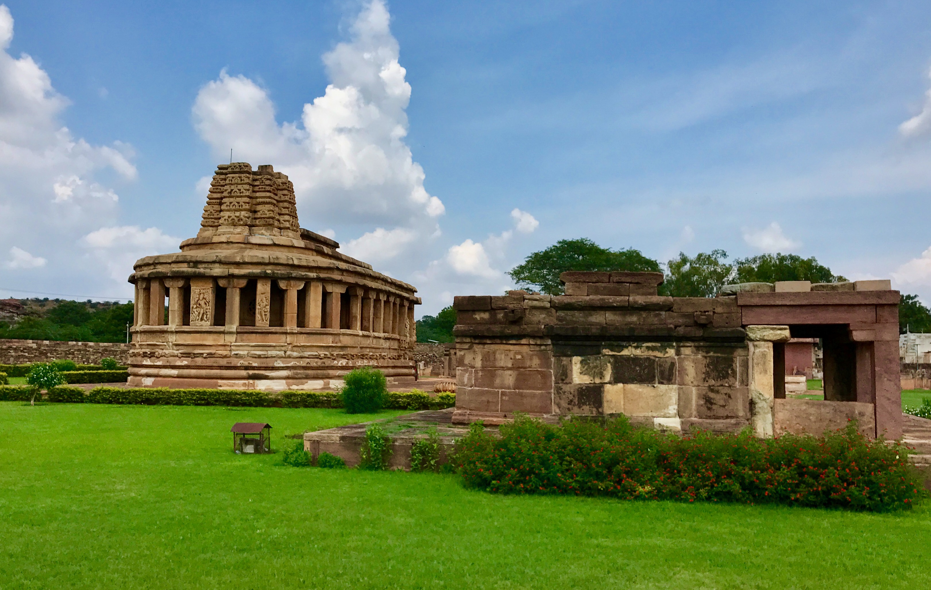
Pattadakal
A treasure trove of Hindu and Jain temples, Pattadakal is part of the Aihole-Badami-Pattadakal complex that is a UNESCO World Heritage Site and it is the best representation of Chalukyan Architecture. Resting on the banks of River Malaprabha, it boasts of a rich legacy that dates back to the 4th century. Excavations have revealed that the region was originally called Raktapura and was under the control of the Badami Chalukyas.
Dedicated to Lord Shiva, the Hindu temples at Pattadakal are an effortless blend of North and South Indian architecture. Built-in the 9th century by the Rashtrakuta Dynasty, the Jain Temple is the newest addition of this region. Built by Queen Lokamahadevi, wife of Vikramaditya II, Virupaksha Temple is one of the finest examples of South Indian architecture. The various temples that one must visit are Jain temple, Papanatha temple, Galaganath temple, and Sangameshwara temple. The classical dance festival held in January sheds light into the authentic culture and traditions of Pattadakal.
Art historians hold this site in importance because it depicts Hindu and Jain social, political, and religious practices in 8th century Deccan India. The name Pattadakal means place of coronation and this place was used by the Chalukya kings for the very same purpose. It was considered particularly sacred because this is where river Malprabha turned North towards the Kailasha mountain in the Himalayas. This ancient site has been witness to rule and regimen of various kings and dynasties, including the Sangama dynasty and the Mughal empire. All ten temples carry with them, unique stories of their own.
The Virupaksha temple is the grandest and most sophisticated. Built in the year 745 by Queen Lokamahadevi to immortalize her husband’s victory over the Southern Kings, it even served as the inspiration behind Kailasha temple at Ellora Caves. The Mallikarjuna temple commemorates the victory of Chalukya kings over the Pallavas. The Galaganatha temple depicts an eight-handed Lord Shiva, killing the demon Andhaka and wearing a Yajnopavita made entirely of skulls. The Jambulingeshwara, Chandrashekhara, Kadasiddheshwara, and Kashi Vishwanatha temples are small structures, all dedicated to different forms of Lord Shiva and his family. The Papanatha temple lies half a kilometre away from the cluster of other eight Hindu temples. It’s the only structure with an amalgamation of both Dravidian and Nagara styles of construction. The Sangameshwara temple is the oldest temple here but remains incomplete despite being built in several phases. The Jain Narayana temple is almost similar in structure to the nine Hindu temples. The only difference is that instead of carvings and idols of Hindu deities, it houses an idol of a Jina who is a soul who conquers all passions and overcomes all imperfections.
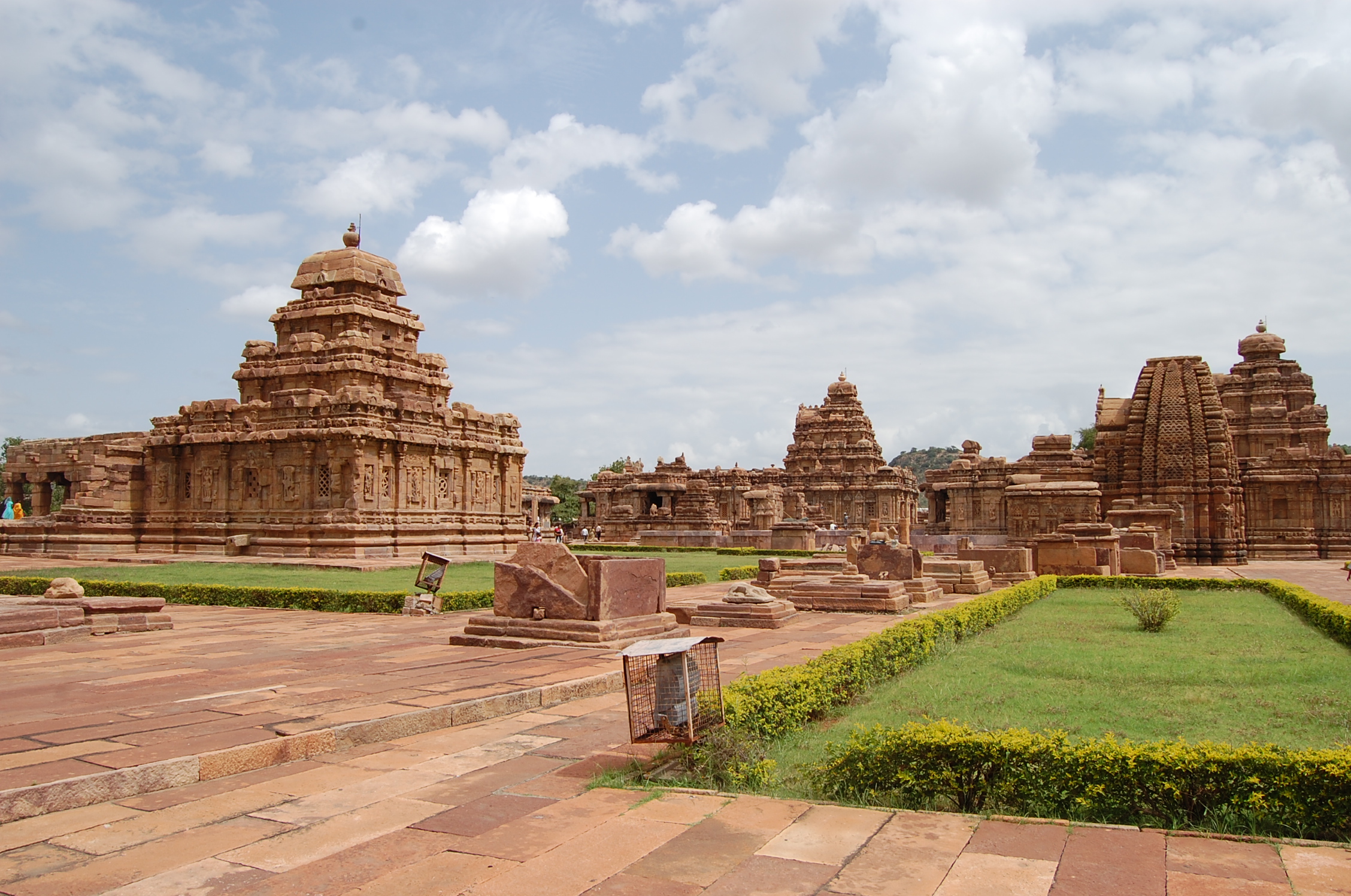
Aihole
Home to over 125 beautiful Chalukyan temples and monuments, Aihole is a historical site which is a UNESCO World Heritage site and is surrounded by marvellous sandstone hills and villages on the banks of the Malaprabha River. It was formerly the capital of the Chalukya Dynasty with over 100 Hindu and Jain temples dating back to around 6th to 12th century. Today, Aihole is a prominent centre for temple architecture and intricate stonework.
Aihole, known initially as Ayyavole or Aryapura, played a significant role in Hindu mythology. Besides Hindu and Jain Temples, Aihole boasts of a rock-cut Buddhist monument and a monastery dedicated to Lord Buddha. The towns of Pattadakkal and Badami are located nearby and together, they form a vast circuit to experience the marvel and grandeur of Chalukyan architecture. A few important monuments in Aihole include the Durga Temple, Lad Khan Temple, Ravanaphadi Cave Temples, Huchimalli Temple, Meganagudi group, Gowda Temple and the Huchappayyagudi Temple amongst numerous others.
There’s an interesting story about how the town got the name. Legend has it that Lord Parashurama, after avenging the death of his father, Sage Jamadagni came to the river Malaprabha to wash his battle axe and bloodstained hands. While doing so, the blood turned the colour of the river water to red. Seeing this horrifying sight, a woman screamed ‘Ayyo Hole!’ in Kannada, which translates to ‘Oh no! Blood!’. Thus, this town got the name Aihole. However, this place is also called ‘Ayyavole’ and ‘Aryapura’. Aihole has great significance to the Ramayana in the Rishi Gautama and the Ahilya part in the epic. In the town, there exists an axe-shaped rock with a foot imprint on it. These prints are said to have belonged to Parashurama.
Aihole is considered as ‘The cradle of Hindu rock architecture’ as legend has it that more than 125 temples were built during Badami Chalukyas rule, between the 5th and 8th centuries. These temples represent different architectural styles like that of Dravidian, Phamsana, Gajaprastha and Nagara. The exquisite sculpture from this period has a classical quality. Richly carved ceilings, intricate rock-cut pillars, isolated figures and flat roofs, are some of the standard features of the temples. The grandeur of the Chalukyan architecture is beyond excellence.
The Chalukya Utsava is a 3-day festival held in early February every year. In addition to cultural activities, this festival also houses several competitions and adventure activities. One of the main attractions of this grand event is the helicopter ride, priced at INR 1,000 per person and hot air balloon ride at INR 2,000 per person, for an aerial view of the ancient city.
During the Pattadakal Dance Festival which takes place on 01 January each year, the
temple car or chariot is pulled from the temple gate to another sculpture called Padhkatte. Devotees from various places come to be a part of this event which is marked by religious as well as cultural celebrations, including prayers, dance and songs.
Kalasa
Kalasa in Kudremukh is a temple town home to Sri Kalaseshwara Temple which is dedicated to Lord Shiva and lies on the banks of the Bhadra river. Kalasa is also renowned for a shrine of Goddess Bhagavathi and a Varaha within a cave.
The locals state the reason behind the origin of Kalasa to be a part of Lord Shiva and Goddess Parvati’s marriage. During their wedding, there was a shift in the rotation of the earth. To maintain the balance, Lord Shiva asked Sage Agasthya to travel to the Southern part. He wasn’t willing as he wanted to attend the marriage. As a solution, Lord Shiva promised him the view of his marriage simultaneously with his stay at Kalasa. He granted an Arcadian vision to the sage which made him possible to witness the holy ritual. Sage Agasthya then travelled towards the South and dwelled in Kalasa from where he watched the wedding of Lord Shiva and Goddess Parvati. Local legends state that a pilgrimage to Kalasa brings great religious merit or punya. Kalasa in Sanskrit means Kalsha, or a pot holding water. According to Hindu temple architecture, every temple should have a round pinnacle placed at the top. This round pinnacle is known as Kalsha. Also, geographically Kalasa is surrounded by River Bhadra from 3 sides and the Duggappana Katte hill at the South. When viewed from above it resembles the pot full of water giving it the name Kalasa.
The Kalaseshwara Temple is situated on a hillock near the Bhadra River built in the Hoysala sculpture style. The temple dome resembles a pot or utensil when viewed from a distance. The Girijamba Temple is dedicated to Girija and the main festival celebrated at this temple two days after Diwali is in honour of the marriage between Lord Shiva and Goddess Girija. The Venkataramana Temple was established in the 15th century and is dedicated to Sri Venkataramana.
So with this we come to the end of a lovely semi series visiting Karnataka. I hope you enjoyed reading about everything this state has as much I as enjoyed researching and writing it. This state has a special place in my life and I have always thought of Bangalore as my second home.