
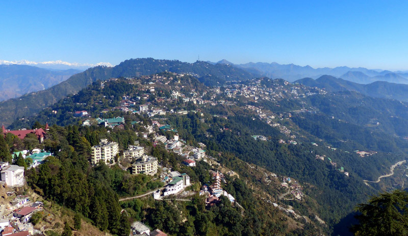
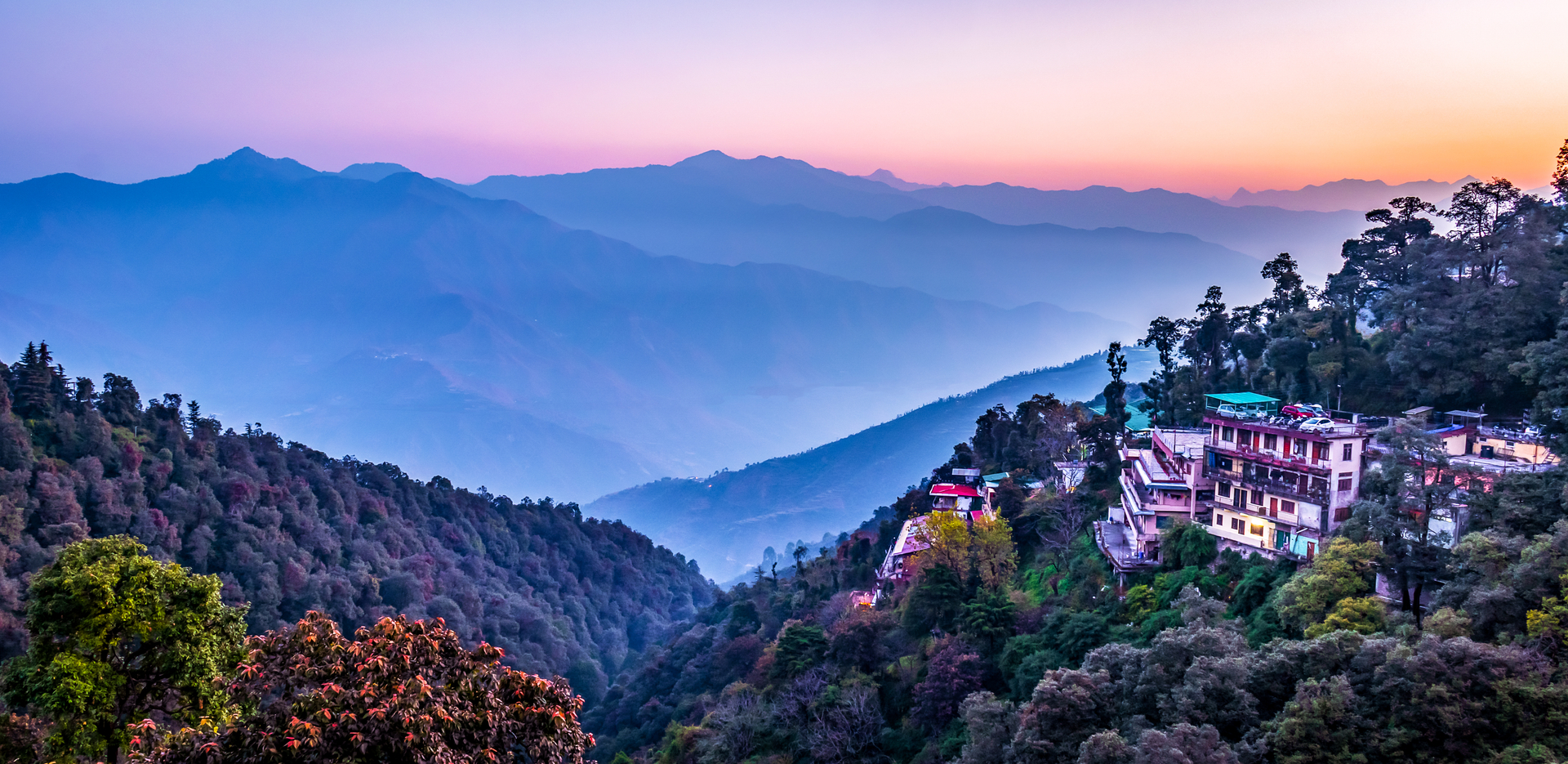
Located in the foothills of the Garhwal Himalayan range and popularly known as the Queen of the Hills, Mussoorie is a hill station and with the adjoining town of Landour, which includes a military cantonment, as well as Barlowganj and Jharipani are all considered part of greater Mussoorie. The town sits at an average altitude of 2,005 meters and has the Himalayan snow ranges to its north and the the Doon valley and the Shiwalik ranges to its south.
The name Mussoorie is often attributed to a derivation of mansur, a shrub which is indigenous to the area and the town is often referred to as Mansuri by locals. In 1803 the Gorkhas under Umer Singh Thapa conquered the Garhwal and the Dehra, during which time Mussoorie was established. On 1 November 1814, a war broke out between the Gorkhas and the British and Dehradun and Mussoorie were evacuated by the Gorkhas by the year 1815 and were annexed to the district of Saharanpur by 1819.
Mussoorie as a resort was established in 1825 by Captain Young, a British military officer. With Mr Shore, the resident Superintendent of Revenues at Dehradun, he explored the present site and jointly constructed a shooting lodge and also raised the first Gurkha Regiment and planted the first potatoes in the valley. Though there are no memorials to commemorate Young in Mussoorie, there is a Young Road in Dehradun. In 1832, Mussoorie was the intended terminus of the Great Trigonometric Survey of India that began at the southern tip of the country. Although unsuccessful, the Surveyor General of India at the time, George Everest, wanted the new office of the Survey of India to be based in Mussoorie; however, a compromise location was Dehradun, where it remains. The same year the first beer brewery at Mussoorie was established by Sir Henry Bohle as The Old Brewery and the brewery opened and closed twice before it was re-established by Sir John Mackinnon as Mackinnon & Co. in 1850. By 1901 Mussoorie’s population had grown, rising in the summer. Accessibility became easier in 1900 with the railway coming to Dehradun, thus shortening the road trip from Saharanpur. The Nehru family, were frequent visitors to Mussoorie in the 1920s, 1930s and 1940s, and stayed at the Savoy Hotel. On 20 April 1959 during the 1959 Tibetan Rebellion the 14th Dalai Lama took up residence at Mussoorie, until April 1960 when he relocated to Dharamsala in Himachal Pradesh, where the Central Tibetan Administration is today headquartered. The first Tibetan school was established in Mussoorie in 1960 and today about 5000 Tibetans live there, mainly in Happy Valley.
Camel’s Back Road: Incorporating a nature walk, Camel’s Back Road is a road, which takes its name from a rocky outcrop in the shape of a camel’s hump overlooking the Doon Valley and contains hotels, motels, and a cemetery with the oldest Christian church in the Himalayas, St Mary’s, above the Mall Road. This road offers stunning views of the Himalayas and is a popular place for viewing the sunrise and the sunset. Taking a long walk along this road or coming here for an early morning jog is the best way to explore what this beautiful road has to offer. You can also see a 180-year-old British cemetery, the first of its kind in Mussoorie, en route the Camel’s Back Road.
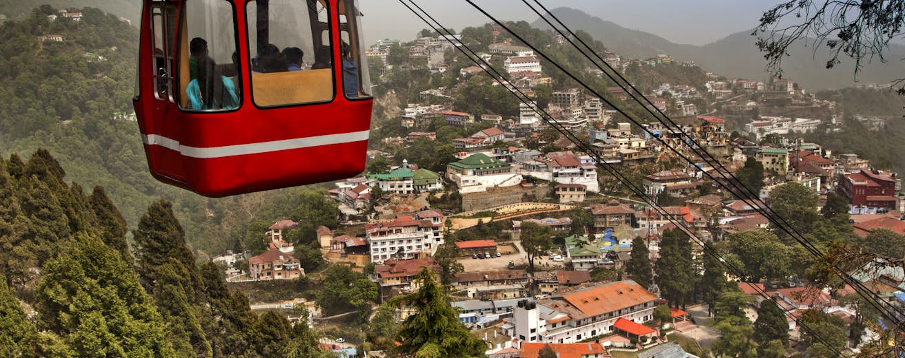
Gun Hill: The second highest point in Mussoorie, Gun Hill is at an altitude of 2,024 m and is accessed by cable car from the Mall road. At Gun Hill is a cannon previously used to sound midday. Said to be an extinct volcano, the view from Gun Hill is a panoramic view of the snow-clad Himalayan ranges right beside the widespread Doon Valley and a full view of Mussoorie. During the British colonial period freedom fighters brought a canon to the top of the hill and fired at the British. After this, the hill which is now part of Woodlawn Cemetery, started to be known as Gun Hill. The road that leads to the hill, previously known as Kingsbridge Road, is now called Gun Hill Road. Another story associated with Gun Hill says that the British brought up a large canon on the hill in 1857 during the Sepoy Mutiny, and the canon was shot every day at noon to set the time. Even though the gun was removed in the 70s, the name stuck. Gun Hill’s highlight of Gun Hill is the ropeway which provides a scenic view of the Himalayan ranges. The ropeway cable car round trip costs INR 75 per head and undoubtedly offers a picturesque view during the climb of the distant hills and green landscapes. The ropeway is open from 10 am to 6 pm daily and during the peak period months of May to July and October, it is open from 8 am to 10 pm and during the months of August, September and from late November to April, it is open from 10 am to 7 pm.
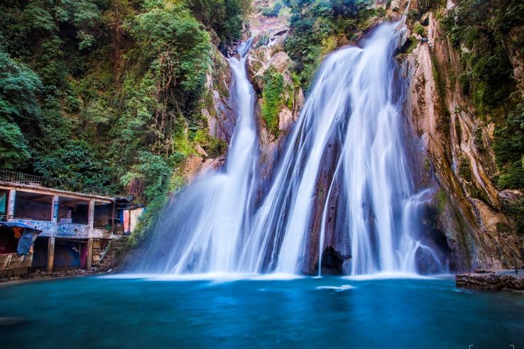
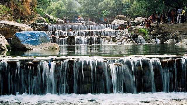
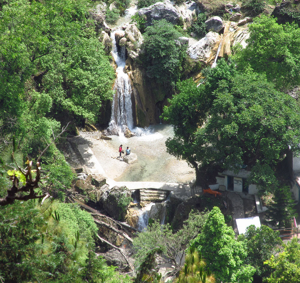
Kempty Falls: Located on the way between Dehradun-Mussoorie roads, in the Ram Gaon area of Tehri Garhwal, Kempty Falls is accessed by track from Kempty Fall Road. Surrounded by high mountain cliffs, Kempty Falls is nestled at an altitude of around 4500 ft above the sea level. The pond formed at the bottom of the falls makes an excellent spot for swimming and bathing. The name of Kempty Falls is taken from the terms camp and tea implying the elaborate tea parties that were once organized here in evenings eventually leading to a localized name Kempty. It was developed as a picnic destination by John Mekinan owing to its captivating surroundings and scenic beauty. Offering a stunning view of water stream cascading down from a great height, it divides into two main falls. The perennial Kempty waterfall is crowded almost throughout the year. One of the best ways to explore the terrain of Kempty Falls is by the means of its ropeway. Precarious and thrilling at the same time, the ropeway takes you over lush green mountains and even overlooks waterbodies and has a cost of INR 80 per person. You can also enjoy boating in the nearby man-made pond and climb from the first main Kempty Falls to the second. The first waterfall is located 5-10 minutes walk from the main road. The second falls has to be reached by walking further inside. The falls are open from 8 am to 5 pm and does not have any entry fees.

Lake Mist: About 5 km before the Kempty Falls is Lake Mist, through which flows the Kempty river with its numerous small waterfalls. The pristine Lake Mist is one of the most beautiful places in Mussoorie with its emerald waters that are covered by green forest terrains from the sides. The lake is not as crowded as Kempty Falls, so it becomes easier to enjoy it. The lake is open from 8 amto 6:30 pm.
Bhatta Falls: Located in the village of Bhatta, the Bhatta Falls in Mussoorie is a popular tourist attraction. Reaching the exact spot of the waterfall requires a little hike of 500 metres. This natural waterfall cascades down from an altitude it 30 feet into a circular pool where people enjoy swimming and bathing. There is a children’s park there as well with slopes and swings provided for them to play. The place has some small eateries as well. The falls are open from 8 am to 5 pm
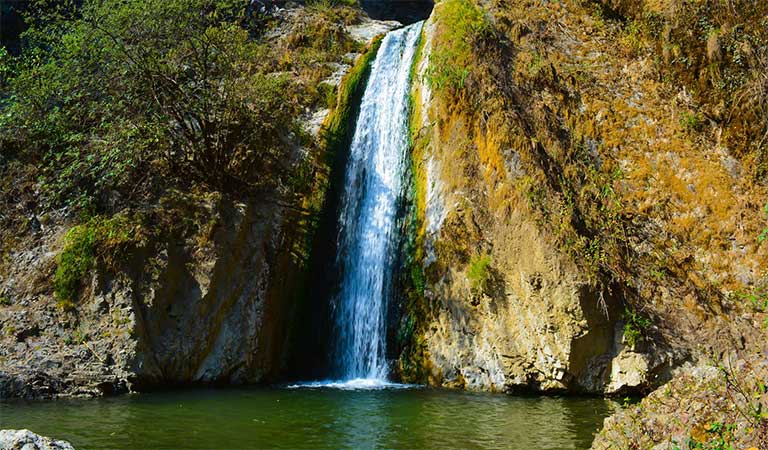
Jharipani Fall: Located 6 km downhill of Mussoorie in the Jharipani village, the Jharipani Falls is a small waterfall which gushes with water just after the monsoons and remains like a thin strip of flowing water during other time of the year. The highlight of Jharipani Falls is the 1.5 km trek to reach the base. On clear days, there is a mesmerising view of the nearby peaks and the amazing valley, especially when the sky is painted a rosy red during the sunset.

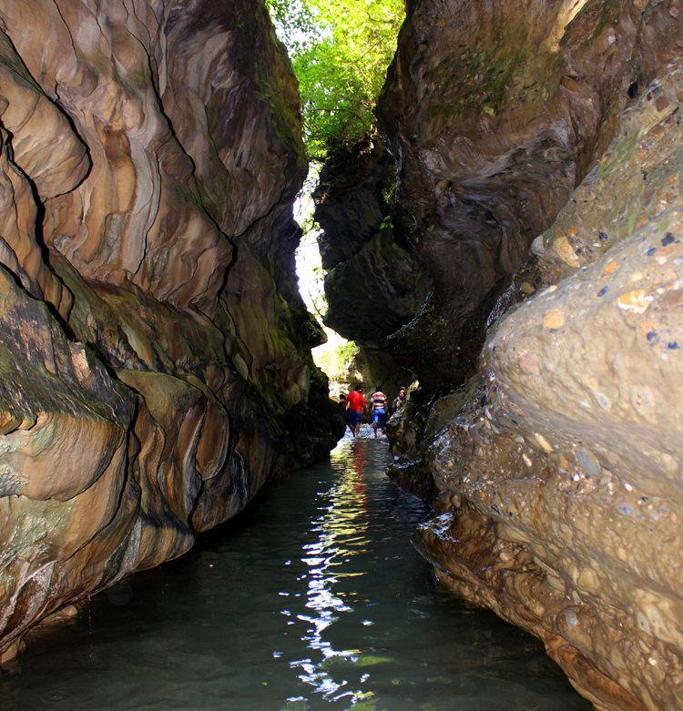
Mossy Fall: Cosily tucked amidst the tantalizing mountains and the exuberant woods, Mossy Fall is surrounded by a dense forest and is accessed via Barlowganj or Balahisar. The falls are a well-kept secret of Mussoorie and are named after the moss-laden rocks surrounding the gushing waterfalls. Literally veiled from view, with a cleft in the hillside, the charming Mossy Waterfalls can be reached with a little bushwhack following slightly rough terrain. The highlight is a Shivalinga hidden near the fall, which is drenched by the continously flowing water, creating a surreal site. The scenic Lake Mossy is a hotspot for trekkers as the trail offers moderate to difficult hikes for the tourists to choose from. In addition to that, it is the go-to place for the photography enthusiasts owing to its rich scenery and minimal human interactions. The falls are open from sunrise to sunset.
Happy Valley: Lying on the western side of Library Point and famous for some magnificent Tibetan monasteries, Happy Valley is more popularly known as Mini Tibet and is one of the most detailed and largest rendition of a typical Tibetan society and home to around 5000 Tibetan refugees. The valley boasts of gorgeous views in the 360 – degree panorama. The story goes that back in 1959, the 14th Dalai Lama escaped from his home in Lhasa, Tibet and was given refuge in Mussoorie by the then Prime Minister of India, Pandit Jawaharlal Nehru. The Dalai Lama stayed in the valley for about a year before he moved to Dharamshala. During this period, a Tibetan school and a beautiful Buddhist temple was established and the valley started flourishing with the Tibetan culture and eventually came to be known as the Happy Valley, owing to its vibrancy, zeal and exuberance. When the Dalai Lama moved to Dharamshala, a large part of the population stayed back and made this valley their permanent home. The Tibetan culture continued to thrive with more temples and monasteries built and in no time the valley came to give the look and feel of a Mini Tibet as it is colloquially called. The Dalai Lama was honoured with the Nobel Peace Prize for which he delivered his acceptance speech on December 10t 1989 and since then the entire valley gets together every year to celebrate the event. Its recommended that visitors time their visit at this time to be a part of the celebrations. The places in the valley are open from 10 am to 6 pm.
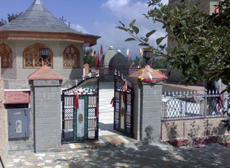
Nag Devta Temple: The ancient Nag Devta Temple on Cart Mackenzie road is dedicated to Snake God Lord Shiva, about 6 km from Mussoorie on the road to Dehradun. There is vehicular access to the temple, which provides a view of Mussoorie and the Doon Valley.
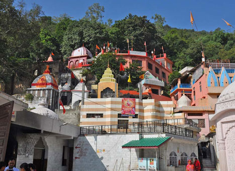
Jwalaji Temple on Benog Hill: At an altitude of 2,240 m the Jwalaji Temple is 9 km west from Mussoorie, and cannot be accessed by vehicle although a motor road goes most of the way from Mussoorie. To get to the temple one has to trek for about 2 kilometers uphill to reach the temple. The path starts from Cloud’s End and passes through thick vegetation of line and deodar trees. The trek offers some panoramic views of the Shivalik ranges, Doon Valley as well as Yamuna River. Atop Benog Hill, it contains an idol of the Goddess Durga and has a view of the valley of the Aglar River. Also known as the Jwala Devi Temple, it is believed that anyone who visits this temple is resurrected from the sufferings of life and is bestowed with sacredness. Apart from pilgrims, nature lovers also visit the place to admire the thick green forest around the temple as well as the Yamuna River and Shivalik range. The temple is open from 5 to 12 noon and then again between 4 to 8 pm.
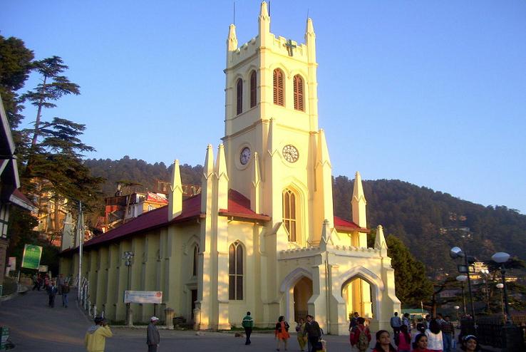
Mussoorie Christ Church: Situated on little hill-lock slightly above the Kasmanda Palace, the Mussoorie Christ Church boasts of being the very first Catholic church in all of the Himalayan region. Built in 1836, the exquisite church is an exemplary example of Gothic architecture which evolved from Romanesque architecture. The prominent style being followed, the church exhibits the pointed arches, ribbed vaults and flying buttresses ideal to the gothic style. Furnished with gorgeous pre-Raphaelite glass windows, this fetching piece of art was a gift to India from the British. The tinted glass window panes tell the tale of life events of Jesus Christ. The high altar is adorned with caricatures about the life and times of Christ from his birth to his sufferings and certification with beautifully done interior walls and a striking century-old William Hill organ. The courtyard of the church still holds the deodar tree planted by the Princess of Wales in 1906 and offers enticing views of the Doon valley on the side. The church is open from 7 am to 6:30 pm, Mondays to Saturdays and from 8 am to 6:30 pm on Sundays.
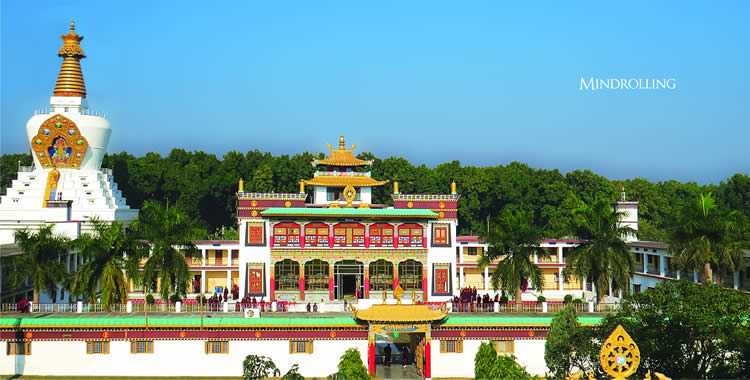
Tibetan Buddhist Temple: Nestled amidst the hustle bustle of Happy Valley is the Shedup Choepelling Temple. The huge idol of Buddha on top of the temple gives a unique charm to the tiny Buddhist temple. Located on the highest cliff of the valley, the Shedup Choepelling Temple is adorned with murals, prayer wheels and meditation chambers. Situated in between the snow-capped mountains, the temple is colloquially known as Tibetan Buddhist Temple and the first Tibetan shrine to be built in India and consecrated by the Dalai Lama. Besides the numerous idols and statues of Lord Buddha, seated in the main hall of the temple are two huge life-like idols of Buddha and the Dalai Lama, as a mark of respect to both. The vibrantly painted walls, tiny clay lamps and prayer flags add to the appeal of the place. The temple also has a rich collection of books on Buddhism and Tibetan literature and offers lovely mesmerising views of the valley, blooming flowers and snow-clad mountains. The temple is open from 7 am to 5 pm.

Cloud’s End: Surrounded by a thich deodar forest, Cloud End is a bungalow, built-in 1838 by a British major and was one of the first four buildings in Mussoorie which has been converted to a hotel today. The Cloud’s End viewpoint marks the geographical end of Mussoorie and is surrounded by thick oak and deodar forests. It tracks 2 km up to the Benog Wildlife Sanctuary offering a lovely walking track, taking in the soothing mountain air and a breathtaking view of the Aglar River Valley. Another major attraction at Cloud’s End is a heritage building set up by a Britisher in 1838, which is one of the oldest buildings in Mussoorie. Retaining the original architecture and other relics, it has now been converted into a heritage hotel, the Clouds End Forest Resort. Tourists spend some tranquil time during their stay, along with partaking in activities like hiking, hill climbing and nature walks arranged by the hotel on request. People often club the visit to Cloud’s End with the famous attractions nearby, the Jwala Devi Temple and Benong Wildlife Sanctuary.
Lal Tibba: Also called Depot Hill because of its former use as a military depot, Lal Tibba, also is the highest point in Mussoorie, with views over the town and its surroundings. A Japanese telescope, with breathtaking views of Himalayan ranges including Badrinath, Kedarnath, Banderpunch, was installed at Lal Tibba in 1967. A popular viewpoint, Lal Tibba is approximately 6 kilometres from Mussoorie and rises to a height of 2,275 meters and is a popular sunrise and sunset point. The Lal Tibba region has long been occupied, serving as a summer getaway during the British-Raj and a recovering station for the military, hence gaining popularity as a cantonment cum hill station. It is now occupied by the Indian Military Services. The main thing at Lal Tibba would be the undisturbed sight of the Himalayan ranges and a snowy white line of ranges can be easily viewed from near Char Dukan, a famous sightseeing café in Landour. There are few spectacular hikes you can undertake in the region, some of which include Pepperpot Mountain and Deo Tibba, a short hike from Tehri road. Lal Tibba is open from sunrise to sunset, so between 6 am to 6 pm and has an entry fee of INR 50 per person.

Van Chetna Kendra: A 339 hectare sanctuary, about 11 km from Mussoori, the Van Chetna Kendra was established in 1993. It is significant for the extinct bird species Mountain Quail or Pahari Bater, which was last spotted here in 1876.
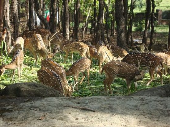
Benog Wildlife Sanctuary: The sanctuary, about 6.3 km from Mussoori and open to the public, provides a woodland habitat for indigenous birds, and animals. A part of the Rajaji National Park, the Benog Wildlife Sanctuary is famous for its almost-extinct mountain quails, deer, leopards and red-billed blue magpie. The wildlife sanctuary is well known to house rare species of birds and offers an excellent trail of pine-clad slopes surrounded by Himalayan peaks for a refreshing walk. It is an ideal site for bird watching and capturing gorgeous views of the surrounding Chaukhamba and Bandarpunch Peaks. Apart from housing the fir and pine trees, the Benog Wildlife Sanctuary also hides some medicinal plants. Also known as Vinog Mountain Quail Sanctuary, it is spread across 339 hectares. The abundant wildlife paired with stunning views of the enveloping scenic vistas makes Benog Wildlife Sanctuary a must visit, especially for the nature lovers and adventure enthusiasts. Open all days of the week, the sanctuary is open from 7 am to 5 pm.
Jabarkhet Wildlife Reserve: The first privately owned and operated wildlife sanctuary in Uttarakhand, the Jabarkhet Nature Reserve is located on the Mussoorie- Dhanaulti road, around 15 kms from the heart of the city and spread over 100 acres of land. At an elevation of approximately 2000 metres above the sea level, Jabarkhet Nature Reserve is set around different altitudinal zones with an extensive variety of rare plants, insects, reptiles, animals, trees, birds and mammals. The wildlife reserve is a hidden gem and an ideal getaway in the bliss of nature. The park houses eight well-demarcated trails for a walk amidst stunning natural serenity. Guided tours are available for birdwatching and wildlife spotting. If you are seeking yet more adventure, you are free to venture off on your own with the help of tour maps which are colour coded and super easy to follow. Open from sunrise to sunset, a non-guided walk costs INR 350 while a guided walk which includes a guide, binoculars, umbrellas and leech socks costs INR 500. The reserve also organises special walks every month, with expert historians, naturalists and photographers. If you are interested, get in touch with them to get on their mailing list. Charges for this vary from INR 600 to INR 1000 depending on the duration of the walk, guide and area covered. They can also organise customised walks for you depending on the difficulty level of treks and the like. The charges for this vary between INR 1200 for day hikes to INR 3000 for overnight hikes. It is recommended to book your hikes well in advance, online or in person.
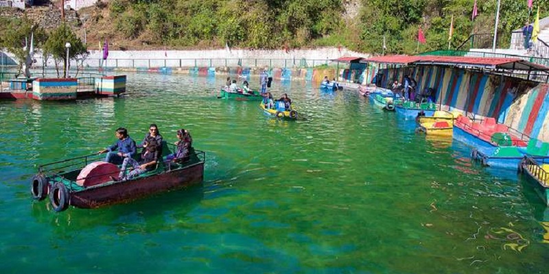
Mussoorie Lake: Located at a distance of 6 kms on the Mussoorie – Dehradun highway, the Mussoorie Lake is an artificial lake developed and maintained by the City Board and the Mussoorie Dehradun Development Authority. Surrounded by a mesmerising natural charm and some surreal views of the charming Doon Valley, this lake offers a rejuvenating retreat in nature’s lap. It’s a newly developed picnic spot originating from a natural waterfall and other than the umpteen outdoor activities available at the site, paddle boating is the most popular one. For a nominal fee, you can paddle your way across the lake to enjoy scenic views of the valley and a serene boating experience. The lake is open from 8 am to 7 pm and there is an entry fee of INR 15 per person.
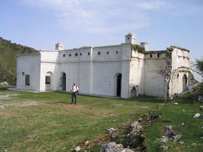
Sir George Everest’s House: At Park Estate are the remains of the building and laboratory of Sir George Everest, the Surveyor-General of India from 1830 to 1843. It is after George Everest that the world’s highest peak Mt. Everest is named. A scenic walk from Library Bazar and 6 km from Gandhi Chowk, the place provides a view of Doon Valley on one side and a panoramic view of the Aglar River valley and the peaks of the Himalayan ranges on the other. Built in 1832, the house is also popularly known as Park House. Sir George Everest owned this house spent 11 years living here and using it as his observatory and laboratory. Although, very derelict and in a precarious state, the house still holds its walls and has a roof; and is likely to be converted into a museum soon. The interiors have been stripped of any belongings but the doors, fireplace and windows still remain in place. The walls have been covered in graffiti though it is whitewashed often. Today the house now comes under the jurisdiction of the Tourism Department. It is open from 10 am to 6 pm and there is no entrance fee to visit.
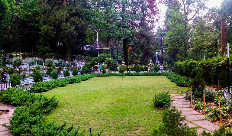
Company Garden: Located arund 3 km from Maill Road, the Company Garden is a popular tourist attraction nestled amidst the high Himalayas. Also known as Municipal Garden, it is maintained by the Garden Welfare Association of Mussoorie and was laid down by Dr H. Fackner in the early years of this millennium. The main attraction of the Company Garden is its vast variety of flora. The lush green carpeted lawn of the Company Gardens is covered with more than 800 types of flowering plants, and during the late spring till the end of monsoon, most of these flowers are in bloom – making the place look like the heaven’s garden. The lawn with a fountain in the middle offers a perfect place to have a little picnic with your friends and families. The heart of the garden is the gigantic China tree which offers a lovely shade during the days the sun shines real bright. The flower shrubs also work as brilliant background for photographs. There is a greenhouse nursery from where you can purchase smaller versions of the flowers you saw out in the garden in little tubs and pots to bring home. There is also an amusement park inside the Company Garden to keep tiny tots busy with safe and exciting rides. There is a man-made lake inside with an artificial waterfall where one can do paddle boating. It costs INR 75 per person for 15 minutes of boating. There is also a shop where you can get yourself photographed by a professional photographer in authentic and traditional Himachali dress. The telescopic view of the surrounding Himalayan mountains, which are otherwise far away and hidden in grey mist, costs INR 10 only. The garden is open between 9 am to 8 pm and has an entry fee of INR 18 per person.
Mussoorie Heritage Centre: Located at a distance of 3 kms from the main market, the Mussoorie Heritage Centre is a social enterprise showcasing the rich culture and heritage of the Mussoorie. Established in November 2013, the Mussoorie Heritage Centre basically displays the archives of the historical heritage of Mussoorie back from 1814 when the National Survey compiled the first map of the region; to 1959, when the 14th Dalai Lama took refuge here in Mussoorie. Started by the father-daughter duo of Vinod Kumar and Surbhi Agarwal, the heritage centre has the objective to preserve and showcase the rich cultural heritage of the town and its adjoining areas. In addition to the numerous exhibits, paintings, artefacts and historic evidence records, the Heritage Centre conducts regular research programmes, curated walks, city tours; to give an elaborate perception on what actual Mussoorie was before commercialisation took over. The Centre has two kinds of exhibitions – Exhibition 1 is the permanent display and representation of ancient pictures, factual paintings, murals and antiques, which define the look and feel of the cultural centre. With a general idea of the evolution of Mussoorie from 1814 to 1949, this exhibition targets to reinstitute the legacy of the hill town. Exhibition 2 is an annual affair with varying topics of interest every year, which runs for a year at a stretch. The topics covered include early modes of transport in the hilly terrain, commercialisation and growth of the tourism industry etc. The centre is open from 10 am to 6 pm daily and has no entry fee.

Soham Heritage Centre: Located on the Chamunda Peeth Temple Road, the Soham Heritage Centre is a private enterprise preserving the rich Himalayan heritage by showcasing the cultural diversity of the Himalayas through paintings, murals, scrap art, frescoes and artefacts. An admirable initiative by Mr Sameer Shukla and his wife Dr Kavita Shukla, the art centre is an effort to display the diversity of the Himalayas through varied art forms. Established in January 2014, the Soham Heritage & Art Centre is the result of around 18 years of tireless planning, inspiration, dedication and collecting of data. Through diverse art forms, paintings, sketches, the Soham Heritage centre aims to educate and inspire the localites and the tourist about the bounteous heritage. Mostly visited by media and architecture students, the centre also conducts occasional workshops and heritage walks to promote the same idea. The centre also has a tiny souvenir corner to help you pick quality antique products including jewellery, musical instruments, utensils, agricultural equipment among other things. The heritage centre is open from 10 am to 5 pm with an hour long lunch break from 2 to 3 pm. It is open on all days except Wednesdays and has an entry fee of INR 100 per person above 5 years of age.
Mall Road: With its architectural evidence of its colonial past, Mall Road contains shops, cafes, video game establishments, skating rinks, a nearby Tibetan market place, and a Methodist church. Located in the heart of Mussoorie, the Mall is a colonial relic with benches and lampposts and visitors can often find the author Ruskin Bond browsing the Cambridge Bookstore. Do try out a photograph in local traditional attire here. Mall Road is open daily between 9 am to 9 pm.
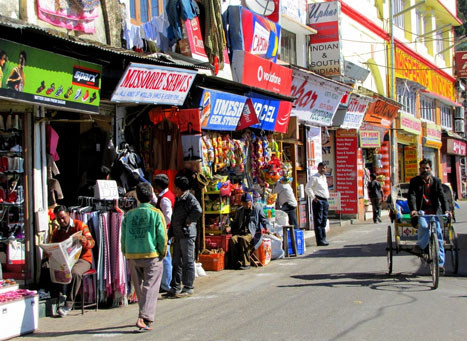
Library Bazaar: Snuggled amidst the eventful Mall Road of Mussoorie is the vibrant Library Bazaar, bustling with energy and vivacity and a stroll in the bazaar can take you back to the vintage times. Arranged along a small circular path, the market oozes with gusto and radiates a colonial feel. The tiny shops dotting the arena perfectly fit into the settlement and present a compressed pretty picture of the entire place. Other than finger-licking street food, local trinkets, handcrafted jewellery, you can find every bric-o-brac at the Library Bazaar. Dribbling with every possible gewgaw knick-knack, this market introduces you to the desi side of Mussoorie. The Library Bazaar gets its name from the 19th-century Victorian style library that was built in the vicinity. Another feature of the popular market is the Band Stand, where you can go to enjoy some good old colonial music. The market also houses a large statue of Mahatma Gandhi in one corner, hence it’s also popularly called as Gandhi Chawk. A haven for compulsive shoppers, the Library Bazaar has something for everyone. The bazaar is open from 10 am to 8 pm daily.
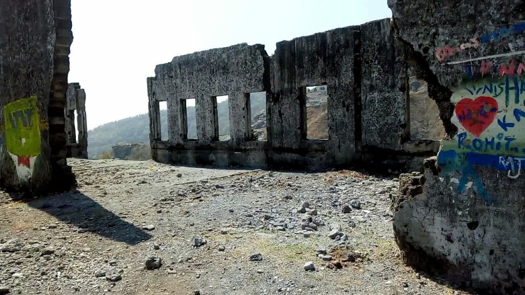
Lambi Dehar Mines: A couple of kilometres from Mussoorie, the Lambi Dehar Mines is an infamous yet popular tourist attraction. Also known as the Mine of Death, it is locally believed that the mines are haunted by a witch. The area in and around the mine is enveloped in lush greenery and surreal landscape but with an eerie and spooky silence. The mine was functional till the early 1990s, after which it was shut down due to the death of around 50000 people working here. While experts say that the death was caused due to inappropriate mining practices causing lung disorders and the eventual death of the people, locals believe that the accident was caused by some spirit who haunts the place still. There have also been reportings of sinister behaviour, blood curdling wails, strange accidents and paranormal activity near the mines, by locals. There have been several road accidents near the spot and a helicopter crash, which perpetuated the belief of witches and hauntings.
Moving on, our next destination is Dhanaulti, a town which is about 60 km east of Mussoori.
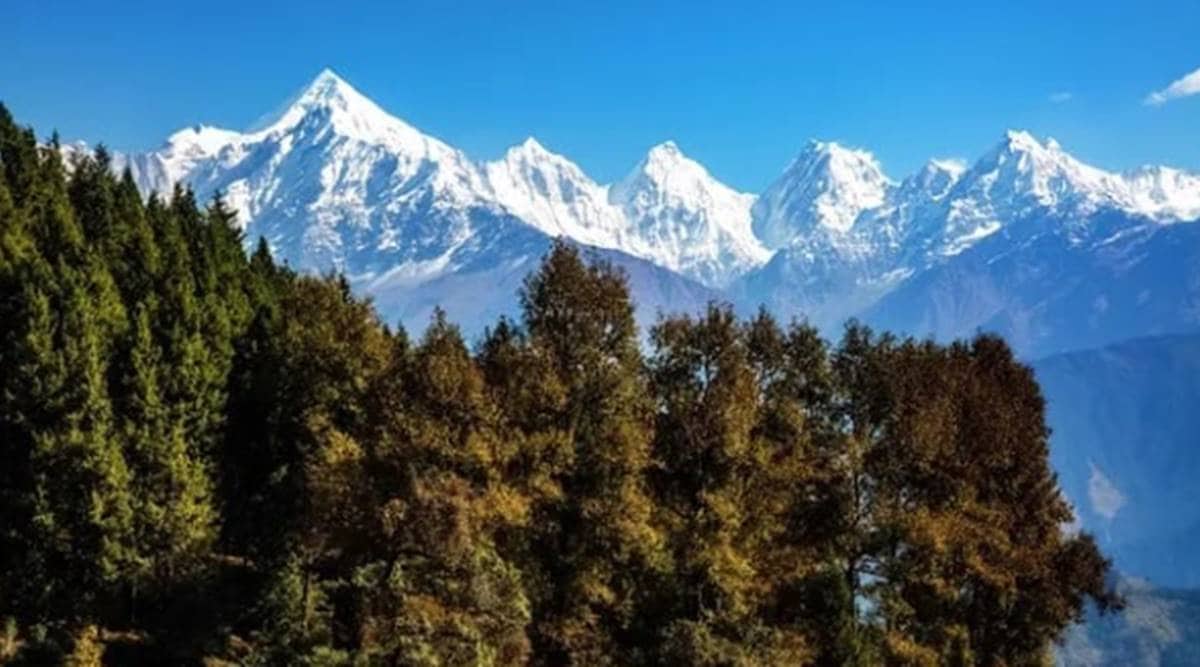
Located at a distance of 62 km from Mussoorie, this little town is an offbeat destination located at a height of about 2200 meters above sea level. A hill station from where the Doon Valley and snow-covered Garhwal Himalayas can be viewed, the town does not have much human presence. A popular attraction built in the 16th century, the Deogarh Fort has many beautiful palaces and has several murals. The place also has a number of Jain temples in and around the area. Another attraction, the Tehri Dam boasts of ultra scenic views of the hills in the backdrop and clear waters in the front. People usually come here to enjoy a day out or a picnic amidst beautiful setting. Originally known as Panchayatan temple, the Dashavatar Temple is located 10 kms away from Dhaulti in Deogarh. The temple dates back to the Gupta Empire and is enshrined by Lord Vishnu. Besides a wonderful architecture, the walls of the temple have beautifully carved panels. The walls also have inscriptions of the Vaishnava mythology. At a distance of about 8 km from Dhanaulti on the road towards Chamba, and a 2 km trek from the village of Kaddu Khal is the Surkanda Temple. While the climb is tough, it’s worth the view and serenity. This temple is based on the popular mythology of Sati jumping in to the sacrificial fire to go against her father Daksha’s act of not inviting Lord Shiva to a ceremony, this temple is one of the most popular Shaktipeeths in India. A Shaktipeeth, going by the literal translation, is a holy site with the female goddess residing for her followers. The temple is famous for its Ganga Dussehra fair in autumn and is part of the Devi Darshan triangle, which offers trekking opportunities around Dhanaulti which include Surkanda Devi, Chandrabadni and Kunjapuri.
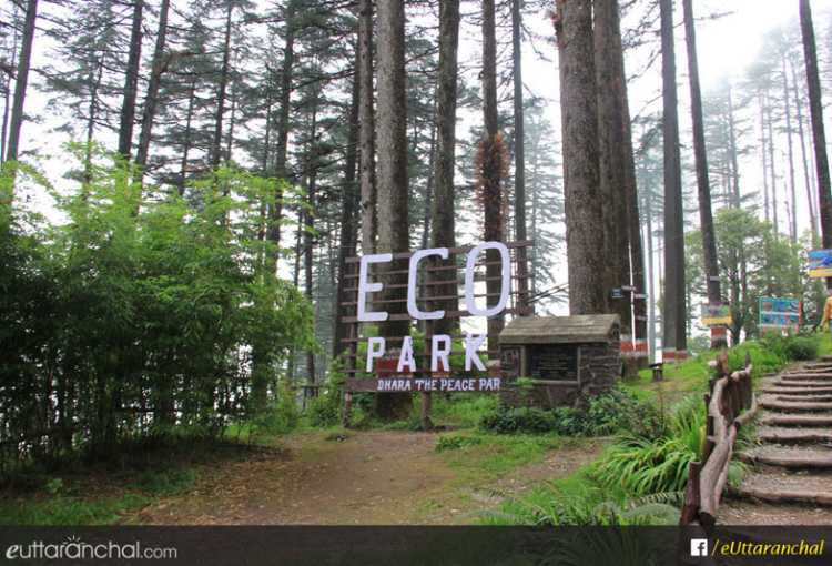
Spread over an area of 13 hectares and covered in deodar and oak trees, the Eco Park at Dhanaulti is a very popular attraction. It was developed by the DFO and the citizens of Dhanaulti to create employment opportunities for the poor as a measure to reduce poverty, the Eco Park is located at the height of 7800 m and enjoys a pleasant weather throughout the year. The park is very well-maintained and is an amazing place for the kids to hang out with a separate playground for them. A tradition known as memory sapling plantation is followed in the park as a part of which one can plant a sapling in memory of their loved ones. The Eco Park is divided into two forests namely Amber and Dhara which are situated at a distance of 200m from each other. One gets a superb view of the Himalayas from this point with the best time to visit the park during sunrise and sunset. The best time to pay a visit to the park is between September and June. The temperature here remains pleasant throughout the year, but monsoons and winters should be avoided. Summers are a perfect time to unwind with the maximum temperature being 31 degrees celcius. The park is open from 9 am to 5 pm and entry fee is INR 15 for an adult and INR 10 for a child. Pretty much every adventure activity you can think of including sky walking, sky bridge, valley crossing, zip swinging, zip lining, trekking, rock climbing, rappelling, paragliding, cave exploration and so much more is available at the Dhanaulti Adventure Park. Located amidst towering hill, snow capped mountains and a magnificent view, it has a perfect mix of leisure and adventure. Another adventure camp, approximately 14 km away from the main market, the Thangdhar Camp is situated at a height of about 8300 feet and surrounded by pine and deodar trees. The camp organises activities like rock climbing, snow camping, trekking or mountain biking as well as sightseeing tours to the nearby Jain temples, which are the structural marvels of a bygone era, intricately carved with the Jain deities. The temples are located in the Kanali Fort, overlooking the Betwa river, and make up for a well deserved break in the journey. The Burma Bridge is a popular camp spot for a perfect campfire experience and the glaciers of Bandarpoonch and Gangotri can be seen far away.
After Dhanaulti, we travel about 325 km east to the town of Auli.


