Bako National Park
Malaysia’s oldest national park, Bako National Park has beaches, cliffs and rock formations. Covering an area of 27 sq km, it envelops the peninsula of Muara Tebas. The wildlife of the park is exceptional with long-tailed macaque monkeys, proboscis monkeys, squirrels and monitor lizards. Proboscis monkeys, unique to Borneo, are a major highlight of this park. It is said that one can witness all the Borneo’s vegetation at Bako.
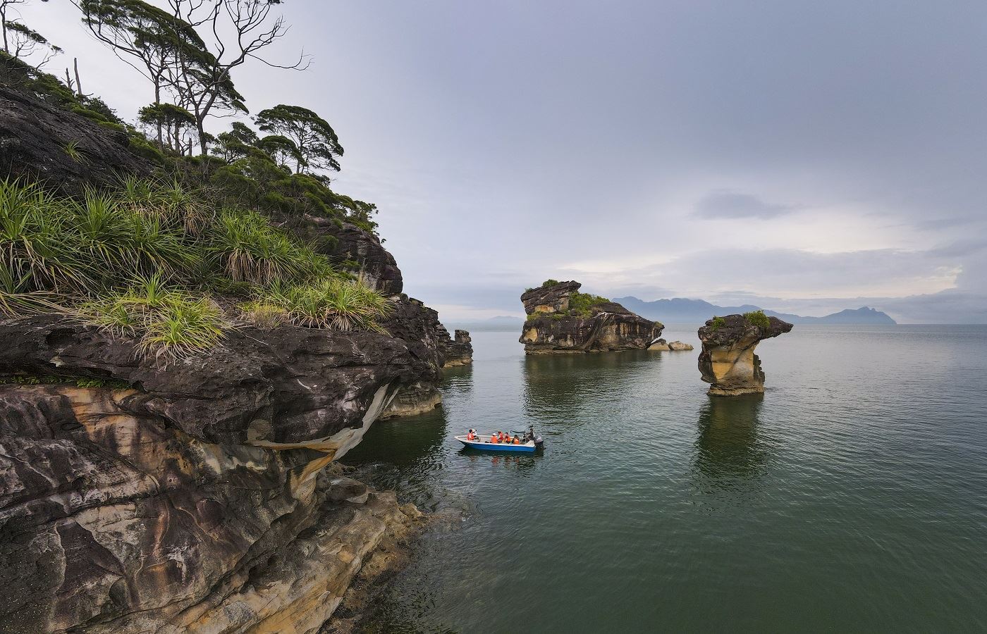
Bako is one of the smallest national parks in Sarawak. However, it features multiple biomes (including rainforest), abundant wildlife, jungle streams and waterfalls, secluded beaches, and trekking trails. A network of 16 marked walking trails of different lengths allows visitors access. In addition, various beaches are accessible by boat from Kampung Bako or Teluk Assam, as well as a geologically interesting sea stack rock formation. The range of attractions and activities in a compact area has made Bako one of the most popular parks in Sarawak.
A distinctive feature of Bako National Park is its picturesque coastlines and bays offering a unique combination of forest by the beach. The sea stack rock formations at the beaches are also among the most visited and renowned places in Bako. Trek by the well-marked trails, wildlife sighting, birding and overnight camping expeditions are some of the most popular activities here, though if one is attempting the longer trails, they have to inform the Park Headquarters before setting out.
Early mornings and just before dusk are the best times for bird sightings at Bako. Guided night walks cost RM 10 per person and let the visitors witness the incredible nocturnal wildlife of the park. Pulau Lakei is a small beautiful island located at the northern tip of the park on the Muara Tebas Peninsula and can be reached by a short boat ride from Kampung Bako.
Bako is famous for the rarely found, but endangered Proboscis monkeys which can be spotted along a few trails like Telok Paku and Telok Delima. It has an incredible variety of birds, with about 150 recorded species. Bako consists of mainly dipterocarp trees and mangrove forests. Carnivores pitcher plants along the Lintang trail are also a major component of the forest.
The Telok Pandan Kecil Trail is a one-hour trail to the Telok Pandan Kecil beach. The beach has several limestone and sandstone cliffs including the geologically famous Sea Stack. Most tourists spend their time in the cool waters at the beach after a tiring walk. However, saltwater crocodiles have been spotted in the waters lately, and swimming on the beach is not recommended. Located near the park headquarters, Telok Assam Beach is very famous among its visitors for its tranquillity and the sight of the swifts that it offers at sunset. These two beaches are also accessible by the boat service provided at the Bako village market.
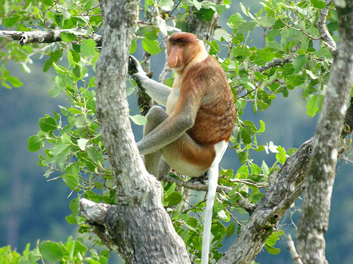
Proboscis monkeys can be sighted on the Telok Paku and Telok Delima Trails. Several tourists visit the park to spot the rare and indigenous Proboscis monkey. The mangroves of Teluk Assam and the trails of Telok Paku and Telok Delima are the famous trails where these are spotted. The best time to go to these places is early morning or late afternoon. Telok Paku is an 800-meter trail that takes about 45 minutes while Telok Delima is a 250-meter trail taking about 30 minutes. The Tanjung Sapi Trail is a 30-minute 800-meter steep trek through the cliff vegetation which gives a mesmerising view of Teluk Assam and the South China Sea. The Ulu Assam Trail is about 1.4 km long from the headquarters which takes about 90 to 120 minutes to trek. The trail passes through the swamp forests and gets steep towards the end. At the end, witness a picturesque view of Bako’s Coastline. Serait is a secluded trail that is 1.2 km long and takes more than an hour to reach the end of the park’s boundary. Bukit Gondol is a 2 km long semi-circular trail that passes through the highest point of Bako, Bukit Gondol hill at 2660 meters. The Ulu Serait Trail connects the Serait Trail and the Bukit Gondol Trail and covers the area consisting of swamp forests and scrub vegetation. To take a shortcut and not climb the Bukit Gondol, switch to Paya Jelutong which consists of several softwood Jelutong trees that are used to make pencils. Lintang is one of the most famous and longest trails covering a distance of 5.5 km in about 3 to 4 hours. The trail passes through the forest, letting the visitors witness all the vegetation in one trail itself. Tajor Trail is a 2.75 km that can be covered in 2 to 3 hours. It covers the Tajor Waterfall and ends at a steep climb to a small beach. Telok Pandan Besar is a 750-meter trail that can be covered in 45 minutes, that ends at a cliff top with a hypnotising view of the beaches. Tanjung Rhu is a 1.8 km trail that diverges from the Tajor Trail towards the Rocky Formations of the Rhu peninsula. Bukit Keruing is a 2.25 km long trail that connects Bukit Gondol to Tajor Waterfalls passing through the slope of the second-highest peak in Bako, Bukit Keruing. Telok Sibur is a 5.3 km trail from the park headquarters, this trail ends at the longest beach of Bako. It passes through the Tajor Waterfall and is very steep at the end. Telok Limau is the longest trail of Bako covering around 6 km one way and 10 km from the headquarters. This trail has incredible vegetation passing through the scrubland, swamp vegetation, small hills and rainforest. Camping is allowed at Telok Limau Beach with prior permission. The Telok Keruin trail is 1.5 km but from the headquarters, it is 10 km. It is one of the rarely taken trails as it is further away from other trails. It is known for scrub vegetation and pitcher plants that come through its way. It also leads to a deserted beach which is secluded and peaceful.
After reaching Bako, tickets to the park and the boat ride have to be purchased. The boat ride from Bako Village to Bako National Park takes about 20 minutes. The Boat Service is open from 9 am to 3 pm and return from the Park has to be planned accordingly. The boat ride costs RM 40 for a return fare for foreigners and RM 30 for Malaysians. It’s RM 200 for a chartered boat return fare. The park is open daily from 8 am to 5 pm and non-Malaysian adults pay RM 20 while children pay RM 7 and Malaysian adults pay RM 10 and children pay RM 3. A permit is required for professional photography or filming.
Batang Ai National Park
A national park that can be accessed by the largest man-made lake, Batang Ai, the Batang Ai National Park is where the Iban made their first settlements. The park covers an area of 24 sq km of extensive tropical rainforest with many rare and protected animals surrounding the 24 sq km artificial lake created by the Batang Ai hydroelectric reservoir. The park was proclaimed in 1991 and has become increasingly popular with locals and tourists despite the lack of facilities with the Iban longhouses a big draw here that gives an insight into the life and history of Iban.
Access is possible by chartering a boat, a traditional boat called a Longboat, as water is the main method of transportation in the area. The ride takes approximately about 40 minutes to the Batang Ai National Park headquarters. The lush dipterocarp forests are home to the orangutan, gibbons, and hornbills. The lake creates a beautiful environment and gives a sense of peace and tranquillity. The local inhabitants are mostly Iban, and tours to nearby Iban longhouses are also a tourist diversion. This national park takes strong steps in having the local communities involved in its management. The communities have formed a cooperative called Kooperasi Serbaguna Ulu Batang Ai and are helping to conserve the park.
The Padlai Trail starts at the Nanga Lubang Baya Longhouse. It follows a 30-m climb to an old burial ground which is referred to as Pendam Sepetang. Then, it passes through the ridge between Nanga Lubang Baya, a crocodile pool, and pig wallows to reach the highest point of the Batang Ai River. Then the trail descends to the Wong Padalai Rapids reaching the picnic spot. The Bilitong Trail is a difficult trail that goes through the Tuchong Bilitong Iban burial site where six tribal leaders are buried. Then it follows the Ulu Sengai Serekong, a 320 m elevated platform. From there, Tuchong Inggai at an elevation of 420 m is an optional climb said to be protected by the spirit of Tugang. It ends at Batang Ai and Lelayang stream where boats pick up trekkers. The Sium Trail is the most difficult in Batang Ai National Park. It is a steady trek for 2.5 km followed by a ridge climb of 415 m. It crosses the Iban burial ground to reach Bukit Sium Ukap, with an elevation of 704 m. On a clear day, the Indonesian lake of Sentarum can be seen. On the way back, one can follow the Berikut River to reach the Tapang tree which is respected among the Iban for its height, white wood and broad branches. The Iban do not cut it as it is believed that cutting Tapan brings bad luck and death. A must-do is the boating in the lake to longhouses. When visiting Batang Ai National Park, one can stay at the Iban longhouse.

Though Batang Ai National Park is famous for Orangutan sightings, there are many more species of wildlife to be found. Several trails pass through the Orangutan habitation area and ensure an Orangutan sighting. Other than orangutans, one gets to witness Gibbons, Bearded Pigs, Langurs and Hornbills.
A permit is required for professional photography and filmmaking. It is to be arranged in advance from the National Park’s Booking Office. The park is open from 8 am to 5 pm on all days, including Sundays and public holidays.

Similajau National Park
Similajau National Park or Samalaju National Park is located about 30 km from Bintulu. The national park, facing the South China Sea, contains rainforests, beaches, and rocky shores. Initially, the park covered an area of 70.64 sq km, extending from Sungai Likau in the south to Sungai Similajau in the north over a distance of 30 km. On February 17, 2000, an additional 19.32 sq km was incorporated into the park, expanding its total size to 89.96 sq km along a narrow coastal stretch.
The park’s flora consists of three main types: beach, kerangas, and mixed dipterocarpaceae forest. The park has 24 recorded species of mammals, including primates such as gibbons, banded langurs, and long-tailed macaques. A total of 185 species have been identified in the park including hornbills and migratory water birds like the Storm’s stork. There are 8 species of hornbill recorded in Sarawak including the rhinoceros hornbill and the black hornbill, which can be found in the park. Occasionally, green sea turtles come ashore to lay their eggs.
12 out of the 20 marine mammals recorded in Malaysia can be found in Sarawak. These include whales, dugongs, and dolphins. Five species of dolphin have been recorded in Bintulu waters: the Irrawaddy dolphin, bottlenose dolphin, Indo-Pacific humpback dolphin, finless porpoise, and pantropical spotted dolphin. Dolphins can be seen in the park from March to September every year. They are often spotted in groups of four or more during the early morning.
The crocodiles in the Likau River consist of two species of riverine crocodiles in the park: the false gharial and saltwater crocodile. The saltwater crocodile is very dangerous and has been responsible for many fatal attacks in Sarawak. The false gharial is generally shy and passive, but on rare occasions, fatal attacks have been confirmed in Central Kalimantan and Sumatra.
The horseshoe crab often appears during the dry season from early May to October. They usually appear in pairs. The males are smaller in size compared to the females, who come to the shore to lay eggs. During the breeding season, Sagor catfishesSagor Catfishes can be seen feeding on the eggs.
Batu Mandi lies about 4 km off the shore of Kuala Sungai Likau and can be reached only by boat. It is noticeable from the park only during low tide. Batu Anchau is a black rock surface situated at the end of the Batu Anchau trail about 2 km from the park office. The Selunsur Rapids can be found at the end of the Selunsur Rapid trail, about 6.8 km from the park office. They can be seen clearly after a heavy downpour. There are two units of Turtle Beach, Turtle Beach I and II. They are located about 6 and 7 km from the park office. They are where turtles go to lay eggs from March to September annually. Sebubong Pool is a natural pool at the Sebubong River that can only be reached by boat.
The Main Trail which is marked in red covers 9.8 km and is towards Golden Beach, and can be reached by hiking or boat. The Education Trail, marked in green consists of two parts: one is a 450 m plank along the mangrove forest and another is a 600 m jungle trail. Here, park office staff teach about the various tree species. The white/red trail, the Circular Trail starts from the end of the mangrove plank walk and meets the main trail at 0.5 km with a total distance of 1.7 km. The Batu Anchau Trail marked in white has a total distance of 2.1 km and ends up at the Batu Anchau rock surface.
Miri-Sibuti Coral Reef National Park
The Miri-Sibuti Coral Reefs National Park is a protected area of coral reefs, off the island of Borneo and a popular dive destination. The Miri-Sibuti Coral Reefs National Park, lying at depths ranging from 7 to 50 metres at the seaward edge, has an average visibility of 10 to 30 metres. The best time to dive is from late March through November each year. Popular diving sites include Anemone Garden, Grouper Patch Reef, Atago Maru Wreck and Seafan Garden. There are also some wreck dives. It is one of Malaysia’s most recently discovered diving locations and the largest offshore national park created in the state.
The reefs house a wide diversity of marine creatures including soft corals like leather corals, sea whips, Bubble corals, staghorn corals, Dendronephthya and Gorgonia sea fans, as well as sponges including elephant ear sponges. Fish species include clownfish, yellow and blueback fusiliers, angelfish, butterflyfish, sea perch, lizardfish, batfish, jackfish, barracudas, Napoleon wrasse and sharks. Other creatures include feather stars, giant clams, nudibranchs, sea anemones and sea horses.

Usun Apau National Park
Usun Apau National Park was designated in 2005 and covers the Usun Apau Plateau in the highlands of central Borneo. Usun Apau is a volcanic plateau covering an area of approximately 1,550 sq km, and averaging 1000 meters in elevation. There are three extinct volcanoes in the centre of the plateau – Selidang at 1,370 m, Kenawang at 1,280 m, and Mabun at 1,280 m. The northern, eastern, and western edges of the plateau end in steep escarpments nearly 300 meters high. Three rivers drop from the northern edge of the escarpment, including the Julan River, which forms the Julan waterfall almost 245 meters high. Streams from the plateau form the headwaters of the Rajang and Baram rivers.
The plateau is covered by montane rain forests, including kerapa, a stunted forest of small trees with gnarled trunks which forms on poor soil with bad drainage, and kerangas forest, made up of tall trees with thin trunks growing on infertile volcanic soil.[2] Hill dipterocarp forest covers the lower slopes of the plateau. The plateau is home to several vulnerable and near-threatened bird species and is designated an Important Bird Area. The gracile slender toad or Ansonia teneritas is known only from the plateau and one other locality. The plateau is relatively inaccessible, with access to the base of the plateau on logging roads, and only trails and no roads on the plateau itself.

In August 2022, Sarawak’s premier announced that the Government of Sarawak would improve road access to the national park, and Julan Waterfall in particular, to open it to tourism, as part of the state’s Post-COVID-19 Development Strategy through 2030.

Bukit Tiban National Park
Bukit Tiban National Park is a national park near Bintulu that encloses the headwaters of the Sungai Nyalau and Sungai Timong Rivers in Miri and Sungai Sigrok, a tributary of Sungai Similajau in the Bintulu. While the forest in the park was logged before 1985, most of the surrounding land has been converted to palm oil plantations, making the area an important refuge for remaining wildlife. Much of the eastern half of the park has however been converted to palm oil in the years since the park was established.
Loagan Bunut National Park
Loagan Bunut National Park is located in Miri. The park was named after the Loagan Bunut Lake nearby, which is connected to the Sungai Bunut, the Sungai Baram and the Sungai Tinjar. This park occupies a space of 100 sq km and is well known for its rich biodiversity and unique aquatic ecosystem. The national park was gazetted on January 1, 1990, and was opened to the public on August 29, 1991
Santubong National Park
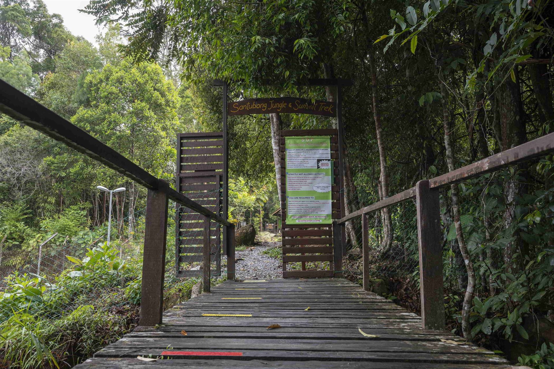
Santubong National Park is located 35 km north of Kuching. It contains the 810 m peak of Mount Santubong and the surrounding rainforested slopes. There are several jungle treks in the park, including to the peak. Wildlife in the park include proboscis monkeys and rhinoceros hornbills. This is one of the best places in Sarawak where one can observe the rare Irrawaddy dolphin, which chooses rivers, estuaries and shallow coastal areas as its habitat.

Rajang Mangroves National Park
Located in Sarikei, Rajang Mangroves National Park is home to species such as proboscis monkeys, silvered langurs, lesser adjutant storks, Irrawaddy dolphins and hornbills. It has a very important role in preserving the coast, from the occurrence of erosion, tidal floods and salt intrusions.