Prisoners of Geography: Ten Maps That Tell You Everything You Need to Know About Global Politics – Tim Marshall
All leaders of nations are constrained by geography. Their choices are limited by mountains, rivers, seas, and concrete. To understand world events, news organizations and other authorities often focus on people, ideas, and political movements, but without geography, we never have the full picture.
Now, seasoned journalist Tim Marshall examines Russia, China, the USA, Latin America, the Middle East, Africa, Europe, Japan and Korea, and Greenland and the Arctic — their weather, seas, mountains, rivers, deserts, and borders — to provide a context often missing from our political reportage: how the physical characteristics of these countries affect their strengths and vulnerabilities and the decisions made by their leaders.
In ten, up-to-date maps of each region, Marshall explains in clear and engaging prose the complex geo-political strategies of these key parts of the globe. What does it mean that Russia must have a navy, but also has frozen ports six months a year? How does this affect Putin’s treatment of Ukraine? How is China’s future constrained by its geography? Why will Europe never be united? Why will America never be invaded? Shining a light on the unavoidable physical realities that shape all of our aspirations and endeavors, Prisoners of Geography is the critical guide to one of the major (and most often overlooked) determining factors in world history.
A couple of months back, there was a video from TED Talks in my inbox which intrigued me. This video, about plastic waste, made me want to read more about this very pervasive issue that will overwhelm us if we do not do something now.
Something that we touch and use hundreds or thousands of times in a day in myriad ways, plastics are a wide range of synthetic or semi-synthetic materials that use polymers as the main ingredient. Their plasticity makes it possible for plastics to be moulded, extruded, or pressed into solid objects of various shapes. This adaptability, plus a wide range of other properties, such as being lightweight, durable, flexible, and inexpensive to produce, has led to its widespread use. Most modern plastics are derived from fossil fuel-based chemicals like natural gas or petroleum; however, recent industrial methods use variants made from renewable materials, such as corn or cotton derivatives.
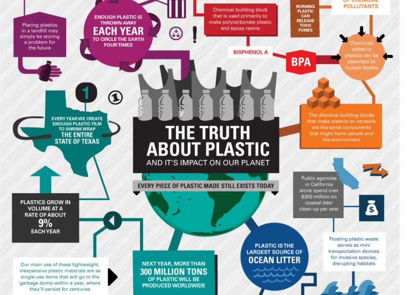
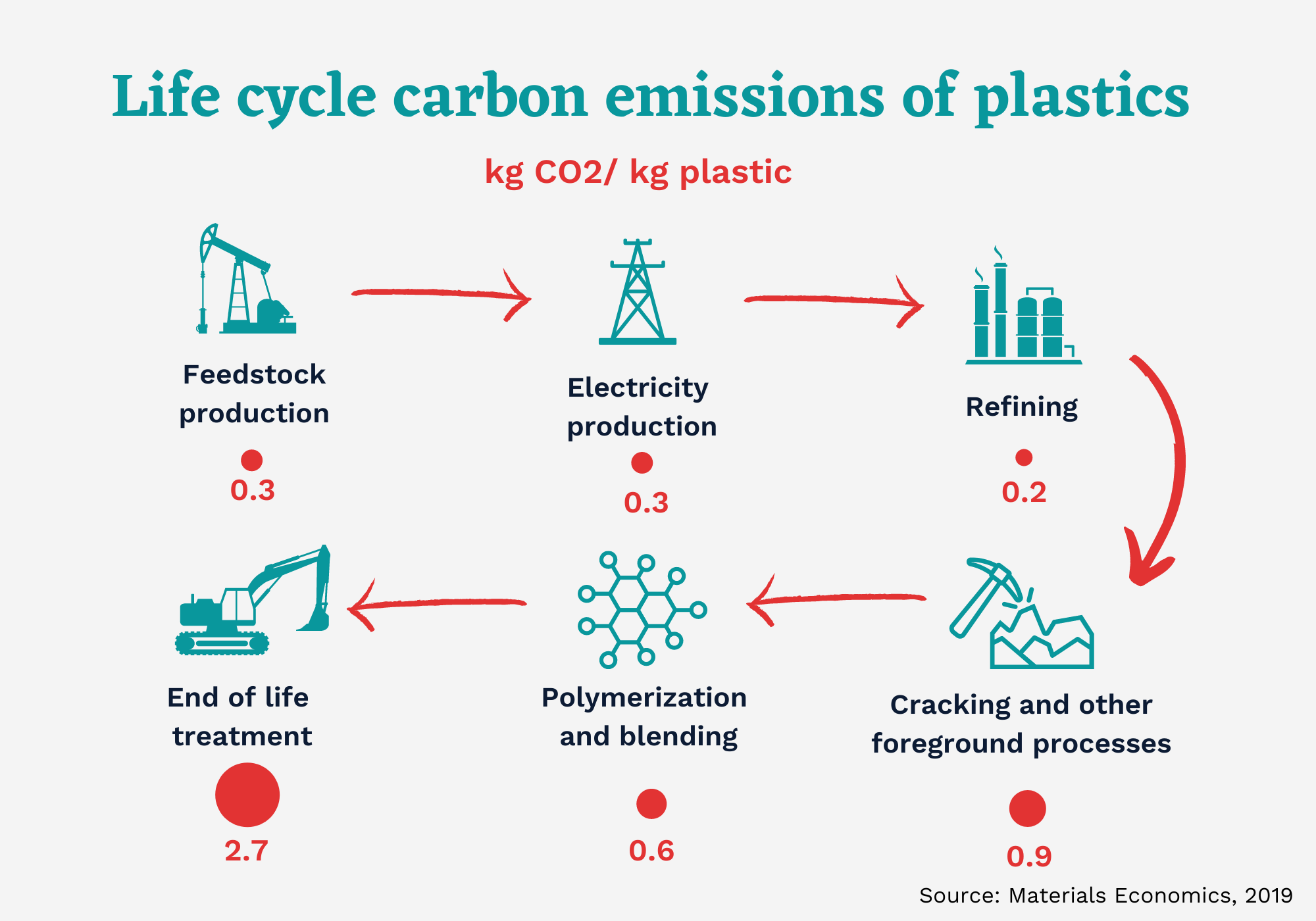
It is estimated that 9.2 billion tonnes of plastic have been made between 1950 and 2017 and more than half of this has been produced since 2004. In 2020, 400 million tonnes of plastic were produced. If global trends in plastic demand continue, it is estimated that by 2050, the annual global plastic production will reach over 1,100 million tonnes. Plastic’s carbon footprint has doubled in less than 30 years, now accounting for nearly 5% of total annual greenhouse gas emissions, accounting for nearly 5% of total annual greenhouse gas emissions. If plastics were a country, titwould be the fifth largest emitter in the world.
Plastic is virtually irreplaceable because it is cheap, strong, lightweight, and resistant to corrosion. Plastic is incredibly useful in modern life, but its widespread use may impair human sustainability. The production and disposal of plastic generate greenhouse gases and hazardous waste. Plastic and the chemicals it emits are building up on land and in oceans, lakes, rivers, ice, and air, and the resulting damage to human and ecological health is currently poorly understood. Most plastic is not recyclable and the vast majority does not biodegrade. Further, plastic products often break down into very small fragments called microplastics that can pollute ecosystems and are harmful to organisms.
While the excessive use of plastic packaging is concerning, some form of packaging is often necessary to maintain the hygiene or freshness of food, or maintain the integrity of a product during freight. Small or travel-size toiletries and personal hygiene products are sometimes seen as wasteful but are vital in providing affordable sanitation options for some of our most vulnerable communities, such as the homeless or low-income families. With an estimated 70% of the world’s population living on less than US$10 a day, toiletries in single-serve sachets provide an affordable sanitation option in developing markets. Plastics are also the cleanest, most efficient way to keep medical supplies sterile.
Replacing plastic with other materials is neither simple nor straightforward, mainly due to the challenge of finding an alternative that combines all the most desirable plastic properties. Biodegradable alternatives—such as special plastics, paper, or cardboard—may well have a higher greenhouse footprint because of the amount of water or natural resources consumed in their production. A study conducted last year by the Nanyang Technological University in Singapore found that reusable plastic bags are more eco-friendly than paper and cotton alternatives, but only in cities and countries with a well-structured waste management system that prevents leakage.
Why is plastic pollution a problem? Plastic is everywhere, from bags and single-use bottles and packages to car parts, pipes, and siding and so plastic waste is ubiquitous. It has been found, for example, in Arctic sea ice, beer, farm soil, trout and other wild freshwater fish, shrimp and other shellfish, songbirds and seabirds, human placentas, the Great Pacific Garbage Patch, midoceanic atolls, sea caves, the air and rain, and national parks and wilderness areas. While the impact of plastic pollution on sea life is well documented, scientists are just beginning to measure plastic’s effects on humans and human fertility, land ecosystems, crops and other plants.
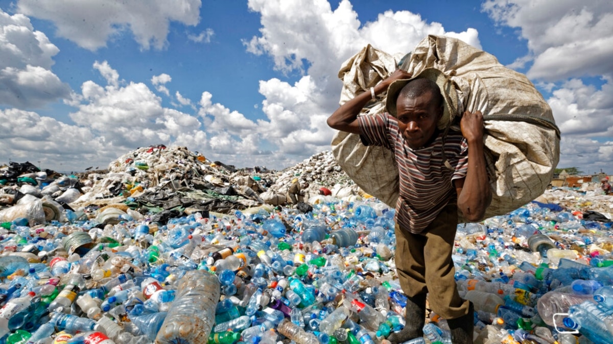
Plastic pollution is most visible in developing Asian and African nations, where garbage collection systems are often inefficient or nonexistent. But the developed world, especially in countries with low recycling rates, also has trouble properly collecting discarded plastics. Plastic trash has become so ubiquitous it has prompted efforts to write a global treaty negotiated by the United Nations.
Researchers estimate that nearly 7,000 million tons of virgin plastic have been manufactured around the world as of 2015. Of that, 9% may have been recycled, 12% has been incinerated, and the rest is in landfills, still in use, or in our environment. Globally, about one-fourth of plastic waste is never collected. In less wealthy countries, waste plastic is sometimes burned in the open, releasing toxic chemicals into the air.
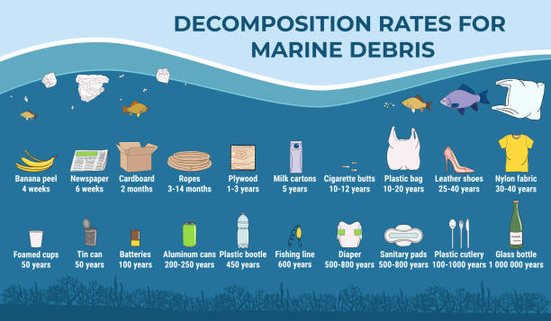
Half of all plastics ever manufactured have been made in the last 15 years. Production increased exponentially, from 2.3 million tons in 1950 to 448 million tons by 2015. Production is expected to double by 2050. Every year, about 8 million tons of plastic waste escapes into the oceans from coastal nations. That’s the equivalent of setting five garbage bags full of trash on every foot of coastline around the world. Plastics often contain additives making them stronger, more flexible, and durable. But many of these additives can extend the life of products if they become litter, with some estimates ranging to at least 400 years to break down. Most of the plastic trash in the oceans, Earth’s last sink, flows from land. Trash is also carried to sea by major rivers, which act as conveyor belts, picking up more and more trash as they move downstream. Once at sea, much of the plastic trash remains in coastal waters. But once caught up in ocean currents, it can be transported around the world. On Henderson Island, an uninhabited atoll in the Pitcairn Group isolated halfway between Chile and New Zealand, scientists found plastic items from Russia, the United States, Europe, South America, Japan, and China. They were carried to the South Pacific by the South Pacific gyre, a circular ocean current. Once at sea, sunlight, wind, and wave action break down plastic waste into small particles, often less than one-fifth of an inch across. These so-called microplastics are spread throughout the water column and have been found in every corner of the globe, from Mount Everest, the highest peak, to the Mariana Trench, the deepest trough.
Microplastics are breaking down further into smaller and smaller pieces. Plastic microfibers, meanwhile, have been found in municipal drinking water systems and drifting through the air. While plastic is durable, this also means plastic waste can be trapped in our environment for centuries, if not managed well. While plastics deteriorate into fragments easily through wear and tear, their polymer chains only break down into other smaller components at very high temperatures, such as during some chemical recycling processes. However, today only 15% of plastic waste is recycled.
Millions of animals are killed by plastics every year, from birds to fish to other marine organisms. Nearly 700 species, including endangered ones, are known to have been affected by plastics. Nearly every species of seabird eats plastics. Most of the deaths to animals are caused by entanglement or starvation. Seals, whales, turtles, and other animals are strangled by abandoned fishing gear or discarded six-pack rings. Microplastics have been found in more than 100 aquatic species, including fish, shrimp, and mussels destined for our dinner plates. In many cases, these tiny bits pass through the digestive system and are expelled without consequence. But plastics have also been found to have blocked digestive tracts or pierced organs, causing death. Stomachs so packed with plastics reduce the urge to eat, causing starvation. Plastics have been consumed by land-based animals, including elephants, hyenas, zebras, tigers, camels, cattle, and other large mammals, in some cases causing death. Tests have also confirmed liver and cell damage and disruptions to reproductive systems, prompting some species, such as oysters, to produce fewer eggs. New research shows that larval fish are eating nanofibers in the first days of life, raising new questions about the effects of plastics on fish populations. Once in the ocean, it is difficult—if not impossible—to retrieve plastic waste. Mechanical systems can be effective at picking up large pieces of plastic, such as foam cups and food containers, from inland waters. But once plastics break down into microplastics and drift throughout the water column in the open ocean, they are virtually impossible to recover.
The world still largely operates on the linear economy model, sometimes known as the take-make-discard model, where raw materials are used to manufacture products, only to be disposed of at the end of their short lifetimes.
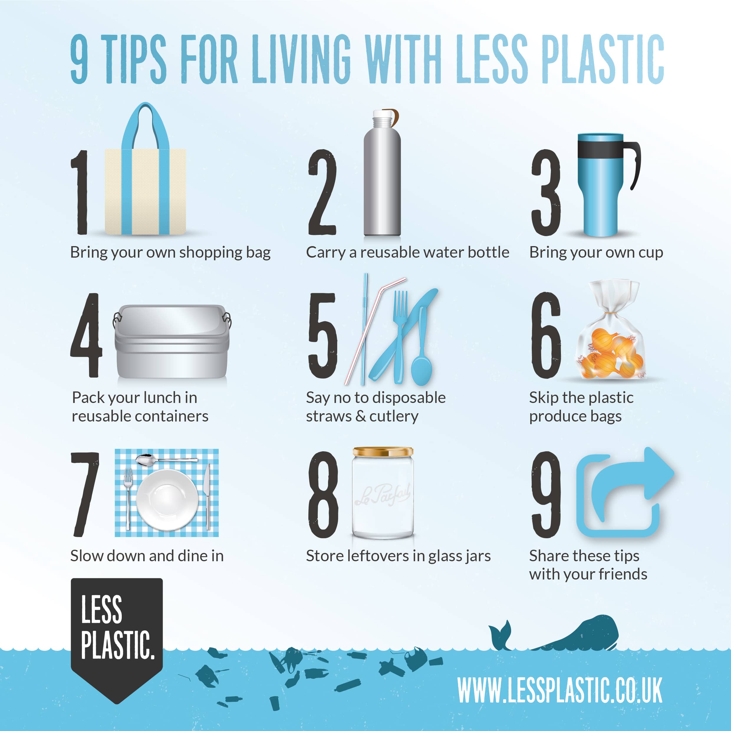
Transitioning to a more sustainable model is not rocket science if one can remember the 3 Rs: Reduce, Reuse, Recycle—in that specific order of priority. Reducing our overall consumption is about respecting our natural resources, only using what we need, and refusing unnecessary excess. Reuse is key to increasing the lifespan of the things we use which includes repairing or upcycling our items to give them a new lease on life. And finally recycling the waste we eventually generate is key to closing the loop in a circular economic model.
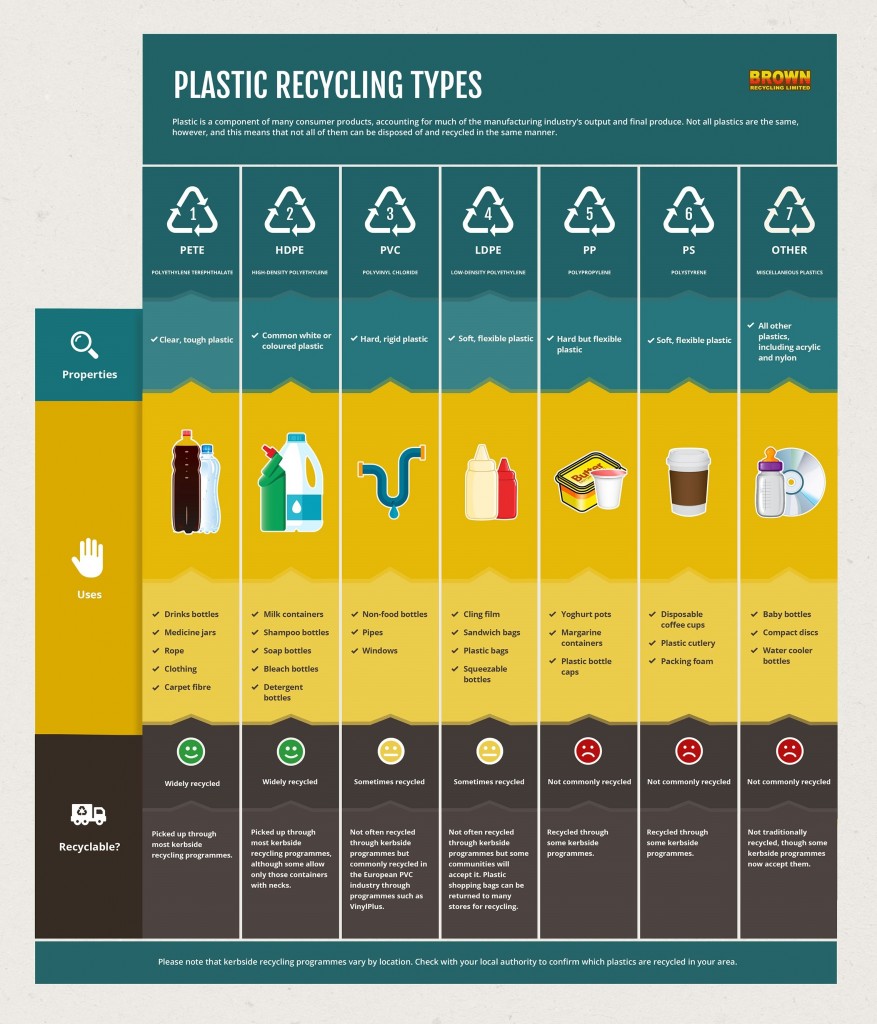
Many consumer plastic products are imprinted with triangular recyclable symbols. But only two kinds of plastic commonly end up recycled: The first is PET or polyethylene terephthalate, and the other is HDPE or high-density polyethylene, and within those, usually only bottles, tubs, and jugs and not salad containers, berry boxes, or clamshell packages. Together, these account for a small fraction of all plastic waste. Recyclable plastics are typically downcycled rather than fully recycled. This means that they are washed, ground into a powder, melted, and then extruded into pellets ready for reheating and remoulding and turned into products of lesser value that often cannot be recycled again. This process is known as mechanical recycling. When plastic waste is turned into a more valuable product, such as clothing or shoes, that is called upcycling. Recycling results in a product of equivalent value that can be recycled multiple times. However, the number of times plastic can be effectively recycled is currently limited. Other hard-to-recycle plastics such as LDPE, polyethylene film, or contaminated plastics like unwashed food containers can sometimes be recycled by using chemical recycling. This is a process where the polymer structure of the plastic is changed and converted into a feedstock that can replace virgin materials used in the production of plastics.
Southeast Asia has emerged as a hot spot for plastic pollution because of rapid urbanization and a rising middle class, whose consumption of plastic products and packaging is growing due to their convenience and versatility. But local waste management infrastructure has not kept pace, resulting in large quantities of mismanaged waste. COVID-19 has exacerbated the situation due to increased consumption of masks, sanitiser bottles, and online delivery packaging.
In Thailand, the Philippines, and Malaysia, more than 75% of the material value of recyclable plastic is lost, – the equivalent of $6 billion a year when single-use plastic is discarded rather than recovered and recycled, according to a series of landmark studies by the World Bank Group. With only 18 to 28% of recyclable plastic recovered and recycled in these countries, most plastic packaging waste is not only left to pollute the environment, littering beaches and roadsides but its value to these economies is also lost.
The world is beginning to accept that it is time to tackle the plastic waste problem. Currently, more than 30% of the world does not have access to proper collection and disposal of waste. There is no silver bullet solution. It’s not about swapping from one single-use lifestyle to another, but instead about changing our behaviour to balance convenience and sustainability, and asking industry and governments to work together to drive the best environmental solutions.
Calling Bullshit: The Art of Skepticism in a Data-Driven World – Carl T. Bergstrom and Jevin West
Bullshit isn’t what it used to be. Now, two science professors give us the tools to dismantle misinformation and think clearly in a world of fake news and bad data.
It’s increasingly difficult to know what’s true. Misinformation, disinformation, and fake news abound. Our media environment has become hyperpartisan. Science is conducted by press release. Startup culture elevates bullshit to high art. We are fairly well equipped to spot the sort of old-school bullshit that is based in fancy rhetoric and weasel words, but most of us don’t feel qualified to challenge the avalanche of new-school bullshit presented in the language of math, science, or statistics. In Calling Bullshit, Professors Carl Bergstrom and Jevin West give us a set of powerful tools to cut through the most intimidating data.
You don’t need a lot of technical expertise to call out problems with data. Are the numbers or results too good or too dramatic to be true? Is the claim comparing like with like? Is it confirming your personal bias? Drawing on a deep well of expertise in statistics and computational biology, Bergstrom and West exuberantly unpack examples of selection bias and muddled data visualization, distinguish between correlation and causation, and examine the susceptibility of science to modern bullshit.
We have always needed people who call bullshit when necessary, whether within a circle of friends, a community of scholars, or the citizenry of a nation. Now that bullshit has evolved, we need to relearn the art of skepticism.
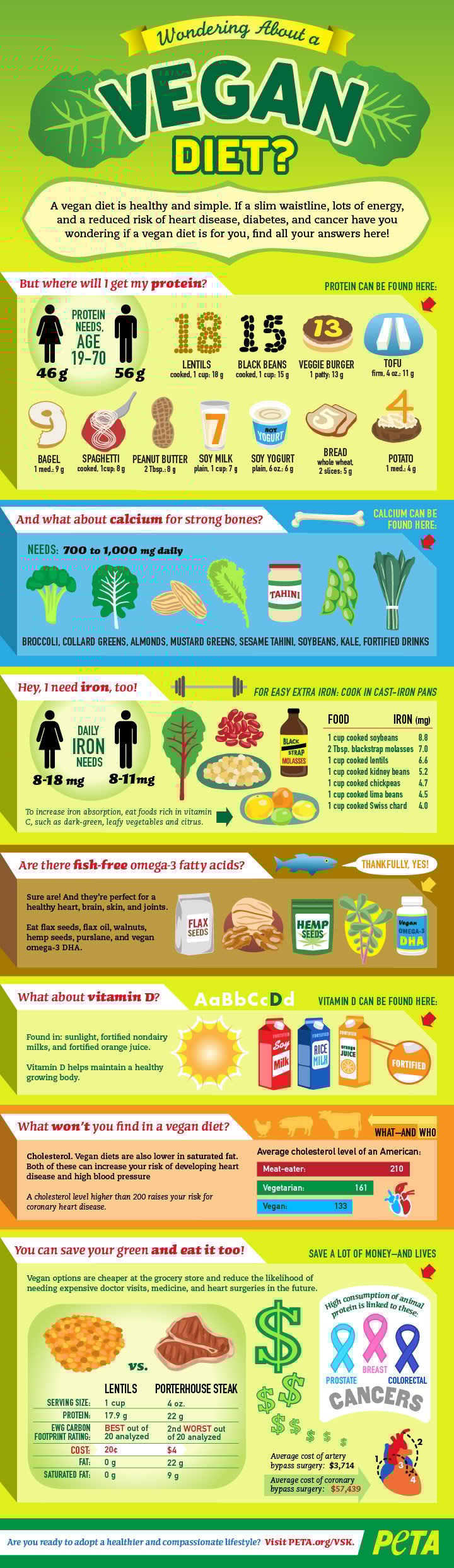
Veganism is the practice of abstaining from the use of animal products, particularly in diet, and is an associated philosophy that rejects the commodity status of animals. An individual who follows this diet or philosophy is known as a vegan. Distinctions may be made between several categories of veganism. Dietary vegans, also known as strict vegetarians, refrain from consuming meat, eggs, dairy products, and any other animal-derived substances. An ethical vegan is someone who not only follows a plant-based diet but extends the philosophy into other areas of their lives, opposes the use of animals for any purpose, and tries to avoid any cruelty and exploitation of all animals including humans. Another term is environmental veganism, which refers to the avoidance of animal products on the premise that the industrial farming of animals is environmentally damaging and unsustainable.
Well-planned vegan diets are regarded as appropriate for all stages of life, including infancy and pregnancy. There is inconsistent evidence for vegan diets provide a protective effect against metabolic syndrome; with some evidence suggesting that a vegan diet can help with weight loss, especially in the short term. Vegan diets tend to be higher in dietary fibre, magnesium, folic acid, vitamin C, vitamin E, iron, and phytochemicals, and lower in dietary energy, saturated fat, cholesterol, omega-3 fatty acid, vitamin D, calcium, zinc, and vitamin B12. A poorly-planned vegan diet may lead to nutritional deficiencies that nullify any beneficial effects and may cause serious health issues, some of which can only be prevented with fortified foods or dietary supplements. Vitamin B12 supplementation is important because its deficiency can cause blood disorders and potentially irreversible neurological damage; this danger is also one of the most common in poorly-planned non-vegan diets. The word vegan was coined by Donald Watson and his then-future wife Dorothy Morgan in 1944. Interest in veganism increased significantly in the 2010s.
World Vegan Day, or International Vegan Day, is celebrated in continuity with Vegetarian Awareness Month which takes place the entire month of October, which begins with World Vegetarian Day on October 1 and includes other commemorative dates involving food security, reverence for life in all species, faith-based vegetarianism and animal advocacy, and more. World Vegan Day follows Vegetarian Awareness Month in October and initiates World Vegan Month which takes place all of November.
World Vegan Day is an annual event celebrated by vegans around the world every 1 November. The event was established in 1994 by Louise Wallis, then Chair of The Vegan Society in the United Kingdom, to commemorate the 50th anniversary of the founding of the organisation and the coining of the terms vegan and veganism. Wallis decided on 01 November because while the Vegan Society was established in November, the exact date was unknown, so she decided on 01 November because it falls exactly between October 31, which is Halloween, and the Mexican Day of the Dead, which falls on November 2. Since November 1, 1994, World Vegan Day has thus provided a welcome occasion for vegans in all parts of the world to celebrate and further promote veganism with all its positive aspects.
If you are vegan, share your thoughts, and your vegan journey which is a great way to encourage more people to be vegan or treat vegan food. You can showcase the benefits and hardships of being vegan and also share delicious vegan recipes or food with others. If you are not a vegan, you can still celebrate World Vegan Day by finding out why some people choose to be vegan is a great way to start. You could also try vegan or vegetarian food options and I can assure you that they are delicious!
The Art of Rest: How to Find Respite in the Modern Age – Claudia Hammond
Today busyness has become a badge of honour. We want to say we’re busy, yet at the same time, we feel exhausted. Instead, we should start taking rest seriously as a method of self-care and this book can help us to work out how.
The Art of Rest draws on ground-breaking research Claudia Hammond collaborated on – ‘The Rest Test’ – the largest global survey into rest ever undertaken, which was completed by 18,000 people across 135 different countries. Much of value has been written about sleep, but rest is different; it is how we unwind, calm our minds and recharge our bodies. And, as the survey revealed, how much rest you get is directly linked to your sense of well-being.
Counting down through the top ten activities which people find most restful, Hammond explains why rest matters, examines the science behind the results to establish what really works and offers a roadmap for a new, more restful and balanced life.


