The Federal Territory of Labuan or Wilayah Persekutuan Labuan in Malay, is an island federal territory that includes Labuan Island and six smaller islands, off the coast of the state of Sabah in East Malaysia. Labuan’s capital is Victoria and is best known as an offshore financial centre offering international financial and business services via Labuan IBFC since 1990 as well as being an offshore support hub for deepwater oil and gas activities in the region. It is also a tourist destination for people travelling through Sabah, nearby Bruneians and scuba divers. The name Labuan derives from the Malay word labuhan which means harbour. Also known as the Pearl of Borneo, Labuan is one of the lesser-explored areas of Malaysia.
For three centuries from the 15th century, the north and west coast of Borneo including the island of Labuan was part of the Sultanate of Brunei. In 1775, Labuan was temporarily occupied by the British East India Company after the failure of the company’s station at Balambangan Island. The Sultan of Brunei, Omar Ali Saifuddin I tried to secure the British East India Company’s support against the Sulu raiders by offering Labuan as an alternative to Balambangan but, instead the company made a second but failed attempt to set up a station on Balambangan. The Sultan’s subsequent reoffering of Labuan to the company did not result in the establishment of a permanent British settlement on the island either.
British policy changed in the 19th century when Labuan started to attract British interest again. Captain Rodney Mundy acquired the island for Britain through the Treaty of Labuan with the Sultan of Brunei, Omar Ali Saifuddin II on 18 December 1846. According to some sources, during the signing of the treaty, the Sultan had been threatened by a British navy warship ready to fire on the Sultan’s palace if he refused to sign the treaty while another source says the island was ceded to Britain as a reward for assistance in combating pirates.
The British acquired the island to establish a naval station to protect their commercial interest in the region and to suppress piracy in the South China Sea. They also believed the island could be the next Singapore. The island became a Crown Colony in 1848 with James Brooke appointed as the first governor and commander-in-chief, with William Napier as his lieutenant-governor. In 1849, the Eastern Archipelago Company became the first of several British companies to try to exploit Labuan coal deposits. The company was formed to exploit coal deposits on the island and adjacent coast of Borneo but soon became involved in a dispute with James Brooke. Not proving itself a great commercial or strategic asset, the administration of Labuan was handed to the British North Borneo Company in 1890. In 1894, a submarine communications cable was built by the British to link the island’s communications with North Borneo, Singapore and Hong Kong for the first time. By 30 October 1906, the British Government proposed to extend the boundaries of the Straits Settlements to include Labuan. The proposal took effect from 1 January 1907.
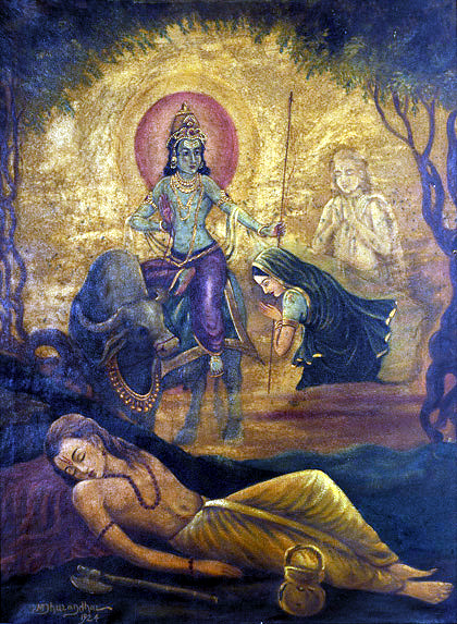
In World War II, Labuan was occupied by Japan from 3 January 1942 until June 1945. The island served as the administrative centre for the Japanese forces. During the occupation, the Japanese Government changed the island’s name to Maida Island or Maeda-shima) on 9 December 1942 after Marquis Toshinari Maeda, the first Japanese commander in northern Borneo. As the Allied counter-attack came closer, the Japanese also developed Labuan and Brunei Bay as a naval base. After the liberation of Borneo, most of the Labuan island area including the main town of Victoria was under the control of Allied forces within four days of the landing on 10 June. On 9 September 1945, the Japanese Lieutenant General Masao Baba officially surrendered at a place now known as Surrender Point near the Layang-layang beach.
The name of Labuan was later restored by the British and the island was administered under the British Military Administration together with the rest of the Straits Settlements. Labuan joined the North Borneo Crown Colony on 15 July 1946, which in turn became the state of Sabah and part of Malaysia in 1963. In 1984, the Government of Sabah ceded Labuan to the federal government and later was admitted as a federal territory. It was declared an international offshore financial centre and free trade zone in 1990.
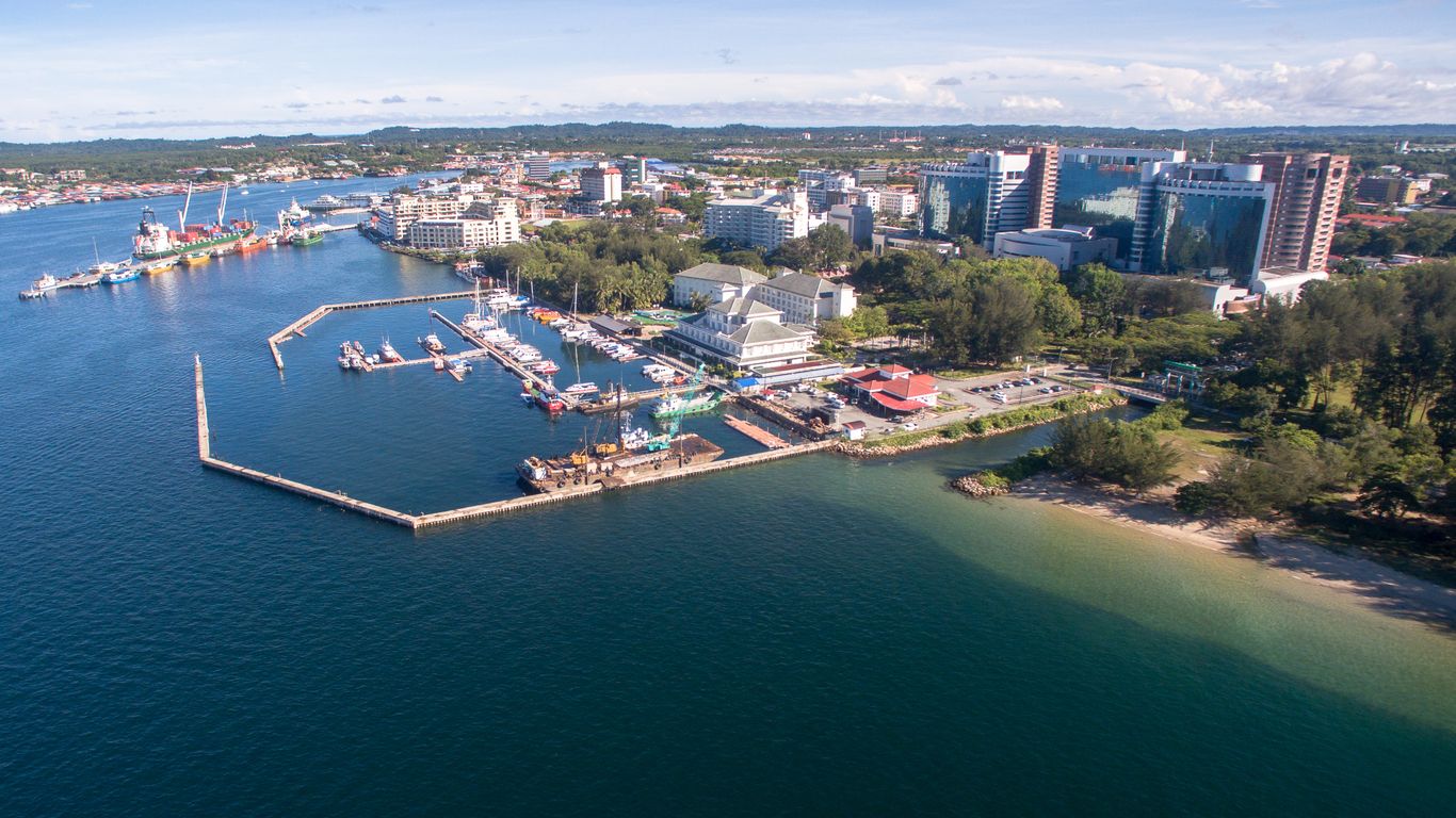
Labuan’s area comprises the main island, Labuan Island and six other smaller islands: Burung, Daat, Kuraman, Big Rusukan, Small Rusukan and Papan Island with a total area of 91.64 square km. The islands lie 8 km off the coast of Borneo, adjacent to Sabah and to the north of Brunei Darussalam, on the northern edge of Brunei Bay facing the South China Sea. Labuan Island is mainly flat and undulating; its highest point is Bukit Kubong at 148 m above sea level. Over 70% of the island is still covered with vegetation. The main town area of Victoria is located in a position facing Brunei Bay.
The economy of Labuan thrives on its vast oil and gas resources and international investment and banking services. Labuan is very much an import-export-oriented economy. The Labuan International Business and Financial Centre, Labuan IBFC was created as Malaysia’s only offshore financial hub in October 1990. In 2010 the notion offshore was excluded from all the statutes of Labuan due to world pressure on tax havens and offshores. Since its inception, the jurisdiction has expanded to become a base for more than 4,800 offshore companies and 68 licensed banks.
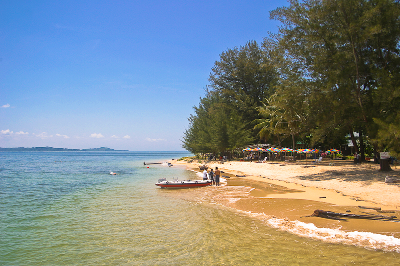
Located on the outskirts of Labuan town, the main Tanjung Batu Beach is a popular attraction amongst the locals in the Southern part of the island. The other beaches on the western coast or other areas are lesser known and an ideal getaway from crowded areas. None of the places are overcrowded and have crystal clear waters with spotless sandy beaches. The beautiful beaches offer breathtaking views of the North Borneo shoreline and calm sunsets. There are also a few food stalls dotted around the beach, serving local food.
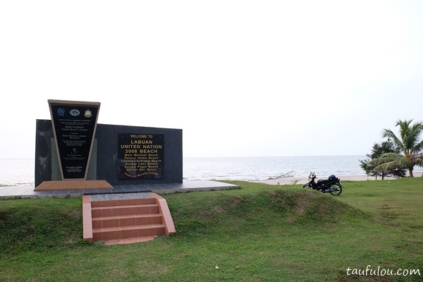
Labuan’s United Nations Beach or UN ’08 Beach is so named for being the recipient of the COBSEA (Coordinating Body on the Seas of East Asia) Clean Beach Award by the United Nations Environment Programme in 2008. Fringed with casuarinas and coconut trees, the UN Beach is a fabulously long stretch of coastline stretching from Pantai Batu Manikar up north to Pantai Sungai Pagar down south. Pantai Batu Manikar, in the far north of the island, is home to the Palm Beach Resort & Spa, one of several beach resorts in Labuan. Batu Manikar Beach is just under 2 km from Labuan Bird Park and Labuan Chimney. Further along, is the gorgeous Pantai Pohon Batu, where one may bask in the sun and enjoy snacks and fresh seafood from stalls that line the coast. There is a small natural path here where one can hike up Bukit Kubong for great views of the South China Sea.
Next up is Pantai Pancur Hitam, where more casuarina trees sway in orderly rows. Home to Labuan’s biggest and most luxurious private homes, the roads surrounding Pantai Pancur Hitam have well-landscaped and decorated pathways. As much a landscaped park as a beach, Pancur Hitam Beach is always packed, and popular with both locals and tourists. Here one can find rows of market stalls offering treats such as fresh coconuts, chicken wings, popcorn and other mouth-watering local delicacies and snacks. Nearby is a sandy park with man-made obstacles called Sudut Cabaran or Challenge Corner, suitable for exercising and team-building activities. There also is a path leading from the beach to the highest point on the island of Labuan, Bukit Phon Batu. Hikers can enjoy beautiful views of the island of Labuan from the peak.
Further south is Pantai Layang-Layangan, a white sandy beach great for relaxing with the calming resonance of waves continuously lapping the shore. Pantai Layang-Layangan is especially popular during weekends. Cycling paths and picnic tables are shaded by leafy trees. Food stalls can also be found here with live musical bands often performing on the weekends. Horse riding and cycling are popular leisure activities in this area. The Peace Park and Surrender Point are also situated just around the corner from here. A nearby atoll called Pulau Layang-Layangan or Pulau Batu Ular, accessible from Pantai Layang-Layangan, is known for the many sea snakes sheltering there. The beach is a 20-minute taxi ride away from the town of Labuan.
The southernmost beach on Labuan’s west coast is Pantai Sungai Pagar. Located near Kampung Sungai Pagar and Universiti Malaysia Sabah Kampus Labuan (UMSKAL), this beach is where the UN COBSEA Clean Beach Award monument can be found. Situated on the east coast of Labuan, Pantai Tanjung Aru is a beautiful stretch of beach that is home to popular seafood restaurants and eateries such as Anjung Ketam Tanjung Aru and Anjung Selera Ikan Bakar Labuan. Also found on Labuan’s east coast, Pantai Tanjung Purun or Labuan Beach is located right by the town centre, next to Ramsey Point and the International Sea Sports Complex.
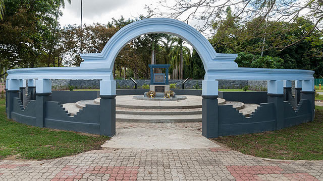
Peace Park is located on the western coast at the Layang Layangan beach, about 8 km from the town. Built as a World War II memorial in 1972, the park has a magnificent mound with an inscription about peace, surrounded by high arched walls. The park has immaculately maintained gardens and trees along with some lakes, ponds and bridges. The place offers some clean toilet amenities if required.
Located on the west coast of the island next to the Peace Park, Surrender Point has a historical significance as the Japanese army completely surrendered themselves to the Allied forces in 1945. It was constructed by the government to acknowledge the importance of World peace and to honour the lives lost in World War II.
The Labuan Chimney was built in the early 1900s and is a remnant of the island’s coal mining era. The 32-metre-tall chimney is made from unplastered red bricks imported from Great Britain, and there is also a museum on site. The adjoining Chimney Museum showcases Labuan’s history of coal mining and also has exhibits on the chimney itself. The museum also houses over 600 exhibits excavated from around the site of the chimney. The Labuan Chimney is popular among photographers.
Located at the northernmost tip of Labuan Island, the Chimney Museum is dedicated to the coal mining history and its practices under the British Empire. Built in the 19th century, this brick building has an extensive display of coal mining artifacts and samples along with a detailed explanation of the coal mining procedures. The place also has an information centre and discovery room to learn about the coal mining pursuits in the country.
The currently existing Labuan Clock Tower is a faithfully recreated replica of the original clock tower constructed by Chee Swee Cheng in 1906. The original clocktower survived the Second World War but was demolished by the British in 1948. The new clock tower was built in 2002. It chimes every hour and is lit up decoratively at night.
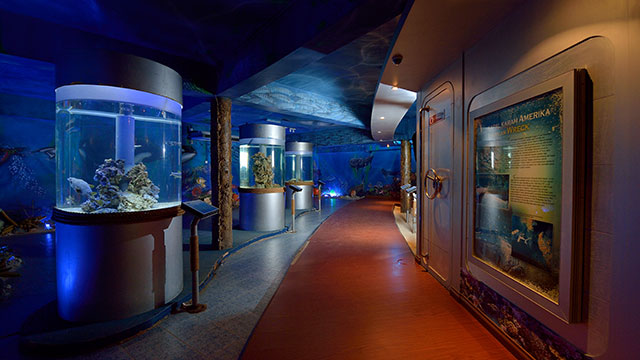
Primarily emphasising marine life, the interesting Labuan Marine Museum is located next to Ramsey Point in town and it aims to educate visitors about life underwater. It showcases a variety of marine exhibits describing the historical importance of the natural heritage. The beautiful aquarium has several tropical fishes and corals along with an enormous whale skeleton outside to study the structure of whales.
The small intriguing Labuan Museum located in central Labuan, was established to display the rich cultural background and heritage of Labuan from the 15th century. A very informative place with details presented concisely, this interesting museum describes the struggle of people to uphold their virtues under Brunei, Japanese and British rule. It exhibits a collection of artefacts from the WWII era, possessions, ornaments, firearms, musical instruments, etc. from over the centuries. It is a few minutes walk from the island’s ferry terminal.
The Patau-Patau Water Village is situated on the outskirts of the town. The village is a well-designed network of beautifully structured houses along with some inter-connected paths bordered with pot plants, built on stilts over shallow blue waters at the Labuan Harbour. The locals are friendly and the houses are pristine and decorated finely with green plants and shrubs providing a lovely insight into Malaysian culture and tradition.
The original wooden structure of the Gurdwara Sahib at Labuan was destroyed in a fire in 1967. The new, two-storeyed Gurdwara Sahib was reopened in 2000. The building has a tiled roof, with a large dome at the centre of the building and two smaller domes on the sides, and is inspired by the Golden Temple in Amritsar, India. The gurdwara is operational, hosting bi-weekly prayers on Saturday evening and Sunday morning, as well as Satsang programmes every Wednesday afternoon.
Located at the Jalan Tanjung Batu, the Labuan War Cemetery is about 10 minutes away from the main town. It is a World War II Memorial that serves as a remembrance of the many unknown Australian, Indian, Malaysian and British soldiers who lost their lives defending the island against Japanese invasion. With a total of 3,908 graves of fallen soldiers, this is Malaysia’s largest war cemetery. A memorial service is held on Remembrance Day once every four years. The territory also has a memorial celebrating the surrender of the Japanese to the Australian Forces in 1945.
Labuan’s Botanical Garden or Taman Botani Labuan is located close to the old airport of the island and was formerly known as the Government House. The recreational park has some fantastic lush green landscapes and scenic old trees. The botanical garden maintains a herbal garden with a variety of herbs and spices along with a beautiful hibiscus garden displaying a large collection of species. These gardens have an artificial lake with an overhead bridge and pathways along with historical remains like storage tanks and graveyards from the WWII era.
Sir Hugh Low, the ex-Colonial Secretary of Labuan known for making the first documented ascent of Mount Kinabalu, is credited with the creation of the gardens. It is beautifully landscaped with a huge variety of tropical plants and flowers, majestic trees and an arched bridge straddling a large man-made lake. The gardens are situated on the grounds of an old Government House built in 1852, shortly after the Brunei Sultanate handed over Labuan to the British on 24th December 1846. Many interesting tales of its past residents, especially during Borneo’s headhunting era, are associated with the house and gardens that once stood there.
Also known as Taman Burung Labuan, the Labuan Bird Park is a well-maintained bird sanctuary occupying an area of 6.9 hectares, located at the extreme north of the island. The park is a scenic area with green tropical rainforests and diverse flora and fauna. It boasts three magnificent geodesic domes that are inter-connected by tunnels allowing birds like peacocks, hornbills, etc. to move about freely in their natural habitat and for visitors to admire. The bird park houses a building within its premises which is a museum. The bird park with over 600 birds is located near the northernmost tip of the island, just opposite The Chimney and about 400 meters from Gedung Ubat. The park is situated about 16 km from the town centre.
Wild and untouched, Labuan Marine Park or Taman Marin Labuan islands offer thrilling adventures for avid nature lovers. The marine park is known for its four wreck diving sites; namely the American, Australian, Blue Water and Cement wrecks. It is formed by 3 beautiful islands affectionately known as the Jewels of Labuan – Pulau Kuraman, Pulau Rusukan Besar and Pulau Rusukan Kecil.
The Kina Benuwa Wetland and Mangrove Forest Reserve is home to some 16 mangrove species from seven different families. The Kinabenuwa Wetland is a pristine mangrove forest occupying the southern end of Labuan. It is located on the lower Kinta Benua River, the longest and widest river network on the island, comprising Sungai Bangat up north and Sungai Bedaun towards the west. The Kina Benuwa Wetland is a conservation area dedicated to the protection of its rich yet fragile biodiversity and ecosystem. It is easily accessible by road from the town centre. Within the area is the Kinabenuwa Mangrove Forest Reserve, home to some 16 mangrove species from seven different families. One can take a stroll along the interconnected boardwalks shaded by mangrove trees and say hello to the mangrove residents, such as mudskippers, giant mud crabs, horseshoe crabs, archerfish, smooth-coated otters, and Asian water monitors, all of whom make occasional appearances. Mangrove forest birds who roam the area include gulls, storks, Chinese egrets, Brahminy kites, and milky storks. There are numerous rest platforms along the way and a restaurant where you can indulge in seafood and exchange tales of adventure after a fun day of exploring.
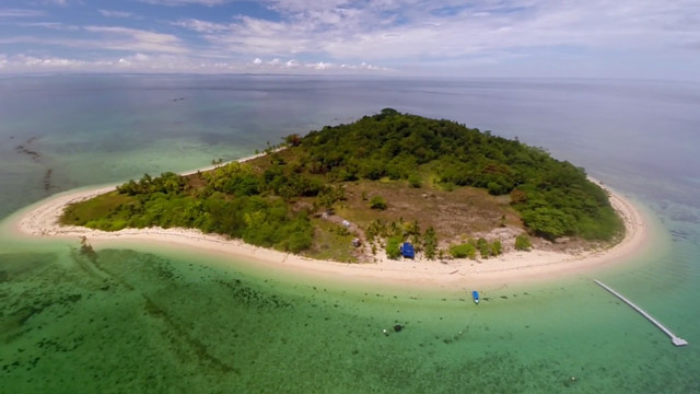
A 5-minute boat ride from Labuan Jetty, the islet of Papan or Pulau Papan is a great place to unwind, whether one is with friends or with family. The clear waters of the island make it an excellent spot for snorkelling and exploring the diverse reef life, while tourists often fly kites and build sandcastles on the sandy shores. Tropical evergreen forests cover most of the island, and hikers can try trekking through the lush green forests. There are numerous campsites across the islet, as well as a few chalets. The small islet, which has a breathtaking landscape and tranquil island atmosphere, is watched over by an old colonial lighthouse. Due to its proximity to Labuan, Papan Island attracts both locals and tourists looking for a short break. It is an especially popular weekend getaway for Bruneians. Much of the island’s surface is taken up by tropical plants and evergreen forests, and visitors may opt to traverse the forest trails to spot small animals and enjoy the natural greenery. In 1994, Malaysia’s Ministry of Agriculture Malaysia developed a mini agriculture park with an interesting collection of regional plant life on the island. Chalets and campsites are available for overnight stays on Pulau Papan.
Out of Taman Marin Labuan’s 3 islands, Kuraman Island is somewhat more desolate in comparison, but not any less beautiful. So inspired was Italian author Emilio Salgari by Kuraman, then known as Mompracem, that the island became the backdrop for the swashbuckling adventures of his most popular character, Sandokan the pirate captain, in the 1900 novel The Tigers of Mompracem. Located about 3 km off the southwestern tip of Labuan Island, permitted activities include scuba diving, camping, snorkelling, sailing, canoeing and jungle trekking. Visitors must follow the marine park regulations at all times and are prohibited from fishing, littering, anchoring and carrying out other activities that may damage the corals and reefs. At 1.47 sq km, Kuraman Island is the biggest in Labuan Marine Park. Pulau Kuraman has two main beaches and is noted for its beautiful, long sand spit leading out to the ocean and pleasant tropical island atmosphere. The island’s interior is forested with a range of timbers and contains cleared paths for jungle walks that lead to a fishing village.
In the surrounding waters off Kuraman, there are several known shipwrecks including the Dutch steamer SS De Klerk and a minesweeper, the USS Salute, both sunk during World War II. Kuraman, like the rest of North Borneo, was captured by the Japanese during this period and was liberated by the Australian Army in 1945, although no fighting ever occurred on the island. Two other major shipwrecks can be found in the area: the MV Tung Hwuang, a freighter that sank in the 1980s while transporting cement to Brunei for the Sultan’s new palace, and the MV Mabini Padre, a trawler from the Philippines which caught fire and sank in 1981. A lighthouse, built by the British in 1897 and similar to the one in Pulau Papan, is situated on the highest point of the island.
A hidden gem located just southwest of Labuan, Pulau Rusukan Besar is famed for its untouched beauty and stunning scenery. Spanning 0.12 sq km, Rusukan Besar Island is the second largest of three islands located within the boundaries of Labuan Marine Park. Also known as Pulau Rugokan Besar, the island is famous for its snorkelling and scuba trails that introduce visitors to an underwater world filled with fascinating marine life. The island can be circled on foot in about half an hour. Rustic and away from the crowds, the Pulau Rusukan Besar offers privacy and the promise of relaxation – it is not uncommon to find the whole island to your group. Other activities include canoeing or visiting the island’s Marine Park Information Centre which is open daily from 9 am to 4:30 pm, which contains fascinating exhibits, photos and information on our oceans and coastal ecosystems. There is also a turtle hatchery on Rusukan Besar Island that is open to visitors and volunteers. At night, there are opportunities near the jetty to spot blue tears, an amazing natural phenomenon consisting of bioluminescent planktons that wash ashore in a bright blue colour. Pulau Rusukan Besar is one of the more developed of Labuan Marine Park’s three islands. The Rusukan Besar Resort, the only one on the island, is a no-frills, full-board resort perfect for those who wish to spend the night here. Accommodation is in the form of striking pink A-frame chalets, and the cabins are equipped with all necessities including air-conditioning, hot water and electricity. The resort comes with a tiki bar and tree house, where meals such as crab porridge are served.
Pulau Rusukan Besar is dotted with coconut palms that thrive on the long stretches of its sandy beaches, and the shade the trees cast makes for perfect picnic spots. Visitors may also enjoy a bout of snorkelling or go swimming in the clear waters. A thick forest covers much of the island, and it is one of the island’s greatest assets. As one approaches this lovely little island cluster, one must be sure to pull up to a stop somewhere in between the islands of Rusukan Kecil and Rusukan Besar to take in the spectacular views of majestic rock formations that adorn Pulau Rusukan Kecil, the smaller of the two islands.
Pulau Rusukan Kecil, also known as Little Rusukan Island, is located between Pulau Rusukan Besar and Pulau Kuraman. At 0.03 sq km in size, it is the smallest of the three secluded islets located within Labuan Marine Park. Beautiful and wild, the island’s surroundings are made up of lush forests and pristine waters. The many secluded beach spots offer unusual privacy and a natural ambience. Visitors can get to Rusukan Kecil Island via a half-hour speedboat ride from Labuan Marina Jetty. Things to do in Pulau Rusukan Kecil include snorkelling, diving, camping, kayaking or just wading in the coral reef atoll. Visitors are also able to explore the island’s quiet tidal pools and forest trails. The island faces the vast South China Sea, thus experiencing a monsoon season with big waves at the end of the year due to northeasterly winds. This situation may prevent fishermen from going out to sea and make bathing activities less suitable due to the strong waves that hit the coastal area. The best time to visit Pulau Pulau Rusukan Kecil is between February and October. Water temperatures hover around 29 to 30°C throughout the year, although it can drop a few degrees during the monsoon season at the end of the year.
Labuan Island has become a popular attraction for divers and snorkelers due to its crystal clear waters that provide great range and visibility along with some beautiful coral reefs, tropical fishes and extensive marine life. The island widely boasts four diving hotspots that are Blue Water Wreck, American Wreck, Cement Wreck and Australian Wreck. On rent diving gear is available at any of the common places close to the diving areas.
There are several hiking trails on the island. By far the most popular trail on the island, there are many interesting stops along the approximately 3.8 km Labuan Chimney Walking Trail, including the Tanjong Kubong Tunnel. Also called Lubang Gantang or Terowong Tanjong Kubong, this is a vertical coal mine shaft reaching depths of up to 40 meters below the ground’s surface. It functions as a gateway for a network of coal mining tunnels located underground. The British graveyard are five tombstones dating back to 1866 and is believed to commemorate workers from the Labuan Eastern Archipelago Company.
Another of Labuan’s popular hiking trails, the Bukit Kubong Walking Trail leads from the beach at Pantai Pohon Batu up the peak of Bukit Kubong Hill, where scenic views of the island and South China Sea await. Bukit Kubong is the tallest hill in Labuan, with a height of 91 meters above sea level. The hill is also a campsite, and it is climbed daily so it is a well-trodden but still clean and wild trail. The area is often visited by large groups consisting of students of all ages and participants in teambuilding events organised by private and governmental establishments. An alternative entry/exit point for the Bukit Kubong Walking Trail is from Kompleks TUDM Bukit Kubong or the Bukit Kubong Royal Air Force Complex. This route is shorter but the track is slightly more challenging.
The Bukit Minyak Gas Trail, or Oil & Gas Hill Trail, is a 2.8 to 3.3 km hiking trail suitable for beginners. The most popular starting point for this route is located near the T-junction or intersection of Jalan Tanjong Kubong and Jalan Pohon Batu, near Pantai Pancur Hitam. The other starting point is located near Labuan Chimney and Labuan Bird Park. The entire trail takes around 2 hours to complete, and hikers may exit the route at the pump station near Kompleks TUDM Bukit Kubong.
The Merinding Trail is frequently used by mountain bikers with entry/exit points at Simpang 19 or Simpang Bukit Aru, Kampung Pohon Batu.
After this short, but very interesting visit, let’s go on to see what Sabah, Malaysia’s easternmost state, has in store for us.