The Lost River: On The Trail of the Sarasvati – Michel Danino
The Lost River explores the geography, history, and mythology, of the Sarasvati river, drawing from various sources like folklore, the Vedas, archaeology, local practices, history, geology, and meteorology. The book explains that the river, its very existence, and its course have been discussed and speculated over for years. The magnificence of the Sarasvati has been detailed in scriptures like the Rig Veda. Historians and archaeologists could not understand how it mysteriously ceased to exist. Some of the even deem the river a myth.
This book attempts the deduce facts from fable and makes a strong case for the existence of the river. It goes over the upheavals that the Indian subcontinent went through thousands of years ago, explaining the dry weather, erosion, and tectonic events that changed the terrain, altered river courses, and may have made the Sarasvati disappear. The book then chronicles explorations into the river started, which began around the early nineteenth century, when it was rediscovered by British officials doing topographic explorations.
The book also explains the culture around that time, shedding light on the Indus valley civilisation and the rich and flourishing culture of Harappa. The book goes on the show the results of explorations into the river’s origins and course using modern technology like satellite imagery and isotope analysis. The author has also used his proof of the existence of the river to bolster his theory that Aryans were indigenous to India and not foreign invaders.
After doing a similar post for Singapore, on the occasion of India’s 75th Independence Day, I had to do one for the city of my birth, my beloved Mumbai.
A Mumbai resident is known as a Mumbaikar, though when it used to be Bombay, we called ourselves Bombayites. I guess the change from Bombay to Mumbai meant that the word also changed and became the Marathi Mumbaikar where kar is the Marathi word for a resident.
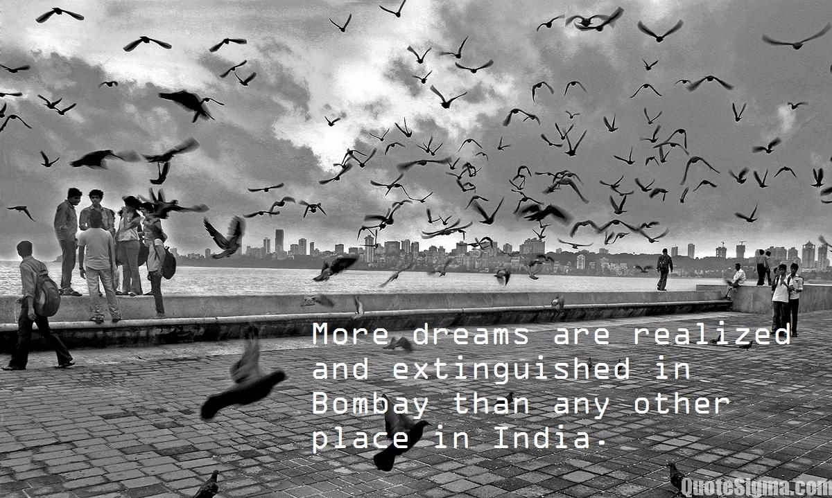
It is said, Mumbai is a city while Bombay is an emotion. Mumbai is full of dreamers and the place where people’s dreams are realised and extinguished. It is said that if one has lived in Bombay and has travelled in the local trains then one can survive in any other city. Officially Mumbai, Bombay is still used interchangeably by many locals.
Mumbaikars live a very fast-paced life and why not, given that the bulk of the population spends a few hours daily just on their commute, whether for school, college or work. I know of friends and colleagues who would spend a minimum of two hours each way on the trains to get to their destination. And speaking of trains, the Mumbai local is the lifeline of the city and if for some reason, trains shut down, the city comes to a standstill. The life of a Mumbaikar, especially one who needs the train to get to work or school revolves around train timings. So their conversations are peppered with train timings and what time to reach the station. And within the train is something that is uniquely Mumbai – the train friends. So what are these train friends? Train friends are those who invariably take the same train as you do daily. Over time, these people become friends. And this is a category of friends who may move outside the train or remain within the train itself.
A Mumbaikar is a perfect amalgamation of pan India. A blend of the North and South and to this is added the Eastern and the Western parts of India which it is already a part of. If you ask a Mumbaikar for directions, you will not be told of the direction in kilometres, but rather the time it will take you to get there. It’s very common to travel long distances to get from one place to the other because unlike other cities, Mumbai is set up in a north-south alignment so this means that long distances are inevitable and this does not faze a Mumbaikar.
Mumbai has one of the highest literacy rates in India, 94.7% which is significantly higher than the country’s average. Though the official state language is Marathi; 16 other major languages are spoken in the city including English. The city is the commercial and entertainment capital of India as well as its most populous city. With a high number of migrants and diverse religious groups, Mumbai is truly a melting pot of cultures. Mumbai can be called the true and first cosmopolitan city of India because this is a city that brings together people of different communities, religions and customs and the city is known for its diversity which can be hard to find elsewhere in India. In any building society, it’s quite easy to see people from many Indian states who live together and celebrate all festivals. The inhabitants of the city can be called a microcosm of India’s population.
The Bambaiya Hindi which is maligned in Bollywood films is a blend of Hindi, Marathi and English. While this brand of Hindi. While the Hindi may not be as pure as what is spoken in Delhi and the northern parts of India, it’s not too bad. What is shown in television and films is an exaggerated version spoken. Neither I nor my family, friends or acquaintances have spoken like this daily.
But at the end of the day, Mumbai has a heart of gold. I have written previously about how the city comes together to help during a calamity or crisis and that is what is important.
A Mumbaikar loves Mumbai, plain and simple and once they identify themselves as a Mumbaikar, they remain one till the end of their lives. I may not travel to Mumbai now as often as I want to, but you can take Mumbai out of my life, but you can’t take the Mumbaikar out of me.
To end this post, an old song which beautifully captures the spirit of Mumbai, though it was Bombay then. This song is from the old classic C.I.D which was released in 1956 and starred Dev Anand and Waheeda Rehman in the leading roles. And this shows you how Bombay was in the fifties, with trams running and wide, uncrowded roads.
The American writer, publisher, artist, and philosopher Elbert Hubbard is the author of today’s quote. Hubbard says positive anything is better than negative nothing. This is a variation of seeing the glass as half full instead of half empty and seeing the positive side of everything in life. What this means is that a positive outlook is what will keep us going when times get tough. Every setback and battle in life makes us stronger to deal with what life throws at us.
This week was the same as previous weeks and nothing happened that I can write about. Singapore celebrated its 57th National Day this week and India will celebrate its 75th Independence Day next week. For the first time since I started to live in Singapore, I did not watch the parade on television. I did not realise the parade has begun and by the time S switched on the tv, I had lost interest in it, so missed watching it for the first time in more than two decades.
From the beginning till now, Singapore has reported about 1.7 million COVID cases with about 1,500 deaths and about 1.6 million who have recovered. Worldwide, 585 million people have been infected with COVID and about 6.5 million lives have been lost to the virus. On the bright side, 12.3 billion vaccine doses have been administered. In Singapore, the elderly, vulnerable and those above 50 have been invited to take their second booster shot. S has already taken his but will get his mum and aunt to get their booster shot done soon.
That’s all I have for today. Stay safe and get vaccinated if you still haven’t and don’t forget your mask, especially when you are around the public, especially in crowded situations.
Daughters of the Sun: Empresses, Queens and Begums of the Mughal Empire – Ira Mukhoty
In 1526 a Timurid warrior-scholar rides into Delhi to build an empire. With him ride his wives, his sisters, his daughters, his aunts and his distant female relatives.
Unhindered by a relatively recent conversion to Islam, these women will help found a culture of such magnificence and beauty that it will become a by-word for opulence in the world. These Mughal women of Hindustan — unmarried daughters, eccentric sisters, fiery milk-mothers and beautiful wives, will contribute to the great syncretic culture of the Mughals by writing biographies, building monuments, engaging in diplomacy, and patronizing the arts.
And even as the zenana changes from the earlier nomadic, tented spaces to the later more sequestered grandeur within the high stone walls of mighty qilas, the influence of the women remains visible and unquestioned. This book looks at the lives of these Mughal women, and the enigma of their disappearance, except as objects of curiosity, from our collective memory.
I have always loved have been fascinated by elephants and when I heard there is a day dedicated to them, I knew this was a post I had to write since today is World Elephant Day.
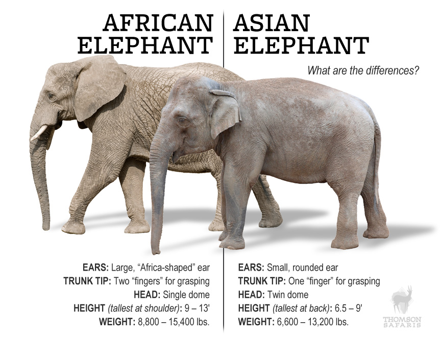
The largest existing land animal, three living species of elephants are currently recognised: the African bush elephant, the African forest elephant, and the Asian elephant. African elephants have larger ears and concave backs, whereas Asian elephants have smaller ears and convex or level backs. The distinctive features of all elephants include a long proboscis called a trunk, tusks, large ear flaps, massive legs, and tough but sensitive skin. The trunk is used for breathing, bringing food and water to the mouth, and grasping objects. Tusks, which are derived from the incisor teeth, serve both as weapons and as tools for moving objects and digging. The large ear flaps assist in maintaining a constant body temperature as well as in communication. The pillar-like legs carry their great weight.
Elephants are scattered throughout sub-Saharan Africa, South Asia, and Southeast Asia and are found in different habitats, including savannahs, forests, deserts, and marshes. They are herbivorous, and they stay near water when it is accessible. They are considered to be keystone species, due to their impact on their environments. Elephants have a fission-fusion society, in which multiple family groups come together to socialise. Females or cows tend to live in family groups, which can consist of one female with her calves or several related females with offspring. The groups, which do not include bulls, are usually led by the oldest cow, known as the matriarch. Males or bulls leave their family groups when they reach puberty and may live alone or with other males. Adult bulls mostly interact with family groups when looking for a mate. Calves are the centre of attention in their family groups and rely on their mothers for as long as three years. Elephants can live up to 70 years in the wild and communicate by touch, sight, smell, and sound, using infrasound and seismic communication over long distances. Elephant intelligence has been compared with that of primates and cetaceans and they appear to have self-awareness and appear to show empathy for dying and dead family members.
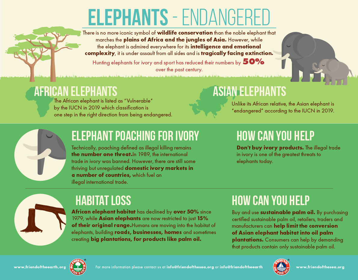
African bush elephants and Asian elephants are listed as endangered and African forest elephants as critically endangered by the International Union for Conservation of Nature or IUCN. One conservationist has stated that both African and Asian elephants face extinction within twelve years. The current population estimates are about 400,000 for African elephants and 40,000 for Asian elephants, although it has been argued that these numbers are much too high. The WWF reports that Asian elephant numbers have dropped by at least 50% over the past three generations. An estimated 35,000 African elephants are still killed every year for their tusks, according to the African Wildlife Foundation.
World Elephant Day is an annual event on August 12, dedicated to the preservation and protection of the world’s elephants. Conceived in 2011 by Canadian filmmakers Patricia Sims and Michael Clark of Canazwest Pictures, and Sivaporn Dardarananda, Secretary-General of the Elephant Reintroduction Foundation in Thailand, an initiative of HM Queen Siriki. Since then, World Elephant Day is recognised and celebrated by over 100 wildlife organizations and many individuals across the globe. This provides citizens, policy-makers, politicians, and governments a way to create and support conservation solutions that will make the world a safe place for elephants, wildlife, and habitat for future generations to cherish. The foundation uses a neutral approach that allows and facilitates everyone to conduct campaigns that demand cooperation across borders and political lines. The day is a rallying call for people to support organisations working to stop the illegal poaching and trade of elephant ivory and other wildlife products, protect wild elephant habitat, and provide sanctuaries and alternative habitats for domestic elephants to live freely.
The goal of World Elephant Day is to create awareness of the urgent plight of African and Asian elephants and to share knowledge and positive solutions for the better care and management of captive and wild elephants.
The demand for ivory, which is highest in China leads to the illegal poaching of both African and Asian elephants. With the street value for ivory now exceeding that of gold, African elephants face a poaching epidemic. Elephants are also poached for meat, leather, and body parts, with the illegal wildlife trade putting elephants increasingly in danger because it is perceived to be a low-risk and high-profit endeavour. The loss of habitat due to deforestation increases in mining, and agricultural activities has become problematic, especially for Asian elephants. The fragmentation of habitat also creates isolation which makes breeding more difficult and allows poachers to find the elephants and set traps more easily. Asian elephants have lost nearly 30-40% of their habitat, making it incredibly difficult to maintain their offspring and themselves. Human-elephant conflict is a significant concern, as human populations increase and forest cover decreases, forcing elephants into proximity to human settlements. Incidents include crop damage and economic losses, as well as both elephant and human casualties. A lack of legislation regarding the care and treatment of elephants in zoos, circuses, and tourism often leads to their mistreatment and captivity can be a serious threat with Asian elephants often illegally captured in the wild and trafficked into the lucrative tourism industry. A lack of legislation regarding the care and treatment of elephants in zoos, circuses, and tourism often leads to their mistreatment.
Elephants have a vital role to play in shaping ecosystems and are considered a keystone species for the role they play. They trample forests and dense grasslands, supporting the growth of smaller species. They also travel vast distances, dispersing seeds in their dung, and supporting vegetation growth. Some research suggests that elephants could disperse seeds up to 65km, which helps to maintain the genetic diversity of many tree species and prevent local inbreeding. Therefore, elephants are critical to the integrity of the African savanna ecosystems.
So on this day, use your voice to spread the word about these gentle giants and support organisations and solutions to better care for them so they can move away from the critical and endangered lists. And before I go, here are some videos of the cutest baby elepants. Watch and smile!


